
the Creative Commons Attribution 4.0 License.
the Creative Commons Attribution 4.0 License.
 | 06 Oct 2026
Field or virtual? Perceived impact of academic excursions through the eyes of (future) hydrologists
Roel Dijksma

Adriaan J. Teuling
Lieke A. Melsen
Victor F. Bense
Martine J. van der Ploeg
Field training such as excursions has always been an integral part of the education of geoscientists. The value of these excursions is frequently debated, related to the efforts and costs involved with their organization. Professionally prepared virtual excursions are sometimes presented as a possible alternative for field activities. This debate has been accelerated by the COVID-19 pandemic: the lockdown forced teachers to come up with virtual and online educational material, also for fieldwork and excursions.
One of the courses at Wageningen University (the Netherlands) that was heavily affected by COVID-19 restrictions was the Master course Catchment and Climate Hydrology. An important and integral component of that course is an 8 d excursion to Iceland where relatively undisturbed catchments are studied in a country heavily affected by climate change. All students from the 2020 and 2021 cohort took the alternative professionally prepared virtual excursion. After the pandemic, in 2022, these students were offered to join an extra added excursion. About 50 % of that population was able to join. This configuration, involving student cohorts that participated only in the field excursion, only in the virtual excursion, or in both, provided an unique opportunity to assess student evaluations of field-based education and the potential of virtual alternatives.
A questionnaire was sent to excursion participants to critically evaluate the impact of the excursion on their scientific development and their view on real versus virtual excursions for geoscientists. The time frame for the questionnaire ran from 2011 to 2025, including COVID-19 years 2020 and 2021.
The response on the statement “Planning and/or fieldwork are an important part of my current job or study” is moderately agree, with > 50 % of the responses even with a response strongly to fully agree. This indicates that field training is very important for the majority of the junior and senior geoscientists. The study also showed that a multiple day excursion to Iceland strongly contributed to the understanding of undisturbed hydrologic systems and to the general scientific development of the participants.
The survey clearly indicated that they appreciated the effort of making a virtual excursion, but that the impact of that virtual excursion on their scientific development was considerably lower than for the equivalent real excursion. The reasons indicated are manifold: they missed the active location-based learning in a country with undisturbed catchments, the inspirational and direct interaction with the teaching staff and linking up with their peers to create a professional network. Therefor the main conclusion of this inventory is that preparing virtual excursions for Master students can be worth the investment, but just as an extra tool in the course tool box, and certainly not as a replacement for real excursions.
- Article
(4168 KB) - Full-text XML
-
Supplement
(387 KB) - BibTeX
- EndNote


In the Geosciences domain, field experiences in the broadest sense are well appreciated as teaching tools by the teaching staff and by the students (Fedesco et al., 2020; Hoyer and Hastie, 2022). State of the art academic education in geosciences often offers a mixture of education methods like classroom lectures, lab practicals and outdoor exercises and excursions. However, opportunities for field training in the curricular part of the educational trajectory seem to have become significantly reduced (Chitty and Hesp, 2024; Jones and Washko, 2022). Multiple day outdoor activities – especially with large groups of students – ask for big budgets and intense planning. Over time, field based education has faced increasing pressure from multiple factors: budget cuts, legal liability, accessibility of field locations, group size, strained or too full academic schedules, education and administrative burden of the teaching staff, and the emergence of technological alternatives (Boyle et al., 2007). On top of that the COVID-19 pandemic required a rapid development of alternative teaching methods, like virtual excursions (Li et al., 2022). Jones and Washko (2021) concluded already in the final stages of the COVID-19 pandemic that the strength of field activities lies in (1) the integration of active learning, (2) the co-creation of knowledge, location-based learning that provides a real-world context and (3) rapid and intense feedback between peers and teachers. The COVID-19 field restrictions have similarities with the foot and mouth disease outbreak in 2001, where also fieldwork of any kind was not allowed in large regions (Fuller et al., 2003; Scott et al., 2006; Scott et al., 2012).
The value of field studies is frequently debated, not in the least by managers and administrators (Chitty and Hesp, 2024). It looks like an easy gain to shift from expensive and time consuming field classes to virtual alternatives. These alternatives are not sensitive to increasing class group numbers, students and staff do not have to leave campus and the costs are lower on the long run and there are no liability issues for the students. The quality of virtual material that can be offered to students has also gained considerably in quality over the years (Pugsley et al., 2022). This all might suggest that it is no longer sacrosanct that field education is crucial for Geoscience education. However, earlier studies (Dickerson et al., 2007; Dunphy and Spellman, 2009; Kern and Carpenter, 1986; Pyle, 2009) showed that lecturers believe field-based education to be an effective and enjoyable teaching method. But are these reasons solid enough for the continuation of field classes? One might ask the question what the status or the role of fieldwork is within the ranks of professional geographers these days (Zelensky, 2001; Bond et al., 2022). More geographers seem to spend their valuable time in meeting rooms and/or by looking at a computer screen (Coucledis, 2009; Seibert et al., 2013). So what is then the point of training field methods? And what is the added value of showing students the complexity of the real world, when it is much easier and cheaper to show a virtual world?
Since 2009, Wageningen University (the Netherlands) offers an 8 d excursion for Master students to Iceland as final part of the course Catchment and Climate Hydrology. These students typically come from the MSc programmes Earth and Environment (now Earth System Sciences), Climate Studies, and International Land and Water Management. The course deals with topics such as precipitation-runoff relationships using physical-mathematical, conceptual, and data-driven models, examples of flood forecasting and hydrological drought analysis techniques (incl. drought propagation), determination of flow generation processes (quick flow, base flow, influence of groundwater system properties on discharge), determination of the effects of global change (including land and forest restoration) on evapotranspiration and streamflow generation and drought development. Special attention is paid to conceptualizing this process understanding into hydrologic models. After course completion, students are expected to be able to analyse systems of multiple hydrologic catchments in various climatologic and hydrogeologic settings at various temporal and spatial scales.
At the final stages of the course, the students are introduced to the hydrogeology of Iceland. This is an intense excursion with long field days and nights spent at camp sites. The main aim of the field excursion is that the students learn to observe and conceptualise hydro(geo)logically and climatologically complex and contrasting catchments – and contrast this with the simplified representation in computer models. At its peak in 2017 in total 64 students and 7 staff were participating in the Iceland excursion.
In 2020 and 2021, all outdoor education came to a halt because of the COVID-19 pandemic (Barton, 2020; Arthurs, 2021; Fischer and Tatomir, 2022; Peace et al., 2021). Alternatives had to be developed rapidly to stay on par with the student schedules. This also holds for the Iceland excursion and in 2020 a professional video team prepared on location materials with the teachers. This virtual excursion was used by the students cohorts of the COVID-19 years 2020 and 2021 to be able to finish the Catchment and Climate Hydrology Course. Even though the virtual excursion was developed with professional recording material and under professional supervision, in April 2022 an additional voluntary Post-COVID-19 excursion was organised for those from the 2020–2021 cohort who (1) were still registered as student and (2) could make time in their schedule for a non-regular excursion. From the 105 students over these 2 years 54 students did join this non-regular excursion (23 from the 2020 and 31 from the 2021 cohort). This configuration provided us with the opportunity to investigate the perceived value of the excursion with a student population that only participated in the real excursion, a population that only had the virtual excursion as study material and a population that first studied the virtual materials and at a later stage participated in the real excursion. This unique combination was used for a thorough evaluation of the added value of international field excursions in Geosciences Master education. The questions/statements fall into three categories: (A) How do concepts for field exploration and model as used during the excursion echo into your current work?, (B) Did the excursion contribute to your cognitive scientific development and (C) Future excursion development: is a virtual excursion a proper alternative and if not, is a more managed area than Iceland a good alternative? Is flying with a large group for course education acceptable?
Iceland, with its steep climate gradients, volcanic and glacial processes, and active tectonic setting, has an unique attraction to future hydrologists and geoscientists in general. The combination of its position on the Mid-Atlantic Ridge and a mantle plume gives it an unique zonation of mostly extrusive rocks in an age range of 20 million years. Add to this that the Gulf Stream (AMOC) flows along the southwestern coast of Iceland, bringing relatively high temperatures and relatively high precipitation amounts. This in contrast to the cold waters of the Arctic Ocean, bringing significantly less precipitation in the northern part of the country. The volcanoes and glaciers create a profound topography up to > 2100 m a.s.l. The mountains and glaciers constitute about 40 % increase in precipitation and cause a drying in the highlands north of the Vatnajökull ice cap and north of the two large Ice caps in central Iceland (Rögnvaldsson et al., 2007; Whitney, 2025). Average annual precipitation ranges from < 400 mm yr−1 in the dry northeast to > 4000 mm yr−1 on some of the ice caps. Because of the relatively mild temperatures in the southwest due to AMOC the country can be seen as rather green (vegetation present), but the highlands and northeast are predominantly just barren rock and unvegetated coarse sediments, see Fig. 1A. The young mafic rocks and the related weathering materials at and close to the Mid-Atlantic Ridge bring conductive subsurface layers, and therefore produce the base flow in the (larger) rivers. The older mafic rocks are less permeable due to pore filling and the development of dikes. In these regions, aquifers have limited capacity, resulting in a (relatively) large amount of overland flow.
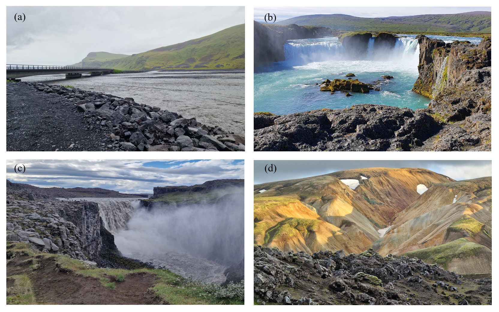
Figure 1Impressions of Iceland rivers and landscapes during the excursion. (a) Braided river Múlakvísl discharging water from the east flanks of the Mýrdalsjökull ice cap, (b) View of the Gođafoss waterfall in the Skjálfandafljót river, (c) View of Dettifoss waterfall in the Jökulsá á Fjöllum glacial river and (d) Rhyolites and obsidian at Landmannalaugar.
The glaciers currently occupy about 11 % of the county area. All Icelandic glaciers and ice caps face a strong net ablation due to climate change. The relative proportion of melt water from the glaciers on river discharge is therefore increasing. In the future, when the glaciers and ice caps are reduced to vague images of what they once were, this share of glacier discharge will continue to decrease strongly. Figure 2 shows a hydrological classification of Iceland (Jóhannesson et al., 2007), in combination with the major rivers (SDI Iceland, 2026). There are not many areas worldwide where there are so many contrasting conditions with groundwater fed, direct runoff and/or glacier fed rivers with a precipitation distribution that varies one order of magnitude. And, on top of that, compared to many other regions the Icelandic catchments can be seen as relatively undisturbed (not heavily managed) systems.
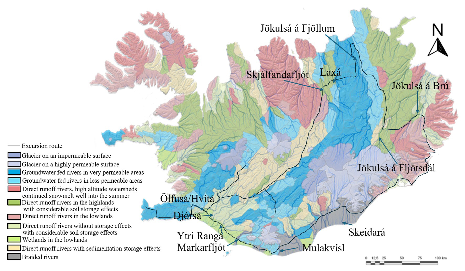
Figure 2Hydrological classification and major rivers (modified from Jóhannesson et al., 2007 and SDI Iceland, 2026). Names indicate major rivers in Iceland which are visited and discussed during the excursion.
3.1 Selection of years of interest and selection procedure
The Iceland excursion was developed in 2008. The years 2009 and 2010 were used to test and improve the excursion with a limited number of students (42 in total). To test the impact of the excursion on scientific development of students and the usefulness in their current work, a questionnaire was sent to a selection of students that participated in the excursion in all years from 2011–2025.
With a total population of 676 participants from 2011–2025, it was decided to send the questionnaire to a limited number of participants. This selection followed 4 steps:
-
Step 1. Random selection of > 10 % of the population of a specific year
-
Step 2. Check on Master program of participant to check representativeness
-
Step 3. Check on available contact information (LinkedIn or other sources)
-
Step 4. When the number of participants to contact is less than 4 participants or < 10 % of the population of that year, select new names
First, a random selection of at least 10 % of the participants of a specific years took place. Preferably this random selection would result in rather equal shares of male and female participants. The minimum number of questionnaires sent was set to 4 per excursion year. Then a check was done on the Master program of these selected participants. Preferably the relative share of participants should more or less be in line with the relative share of students from that Master program participating in the excursion. The next step was the search for available contact information of the participants. The main source for this was LinkedIn. This LinkedIn search not only provided opportunities for contacting participants, but also gave insights into the current affiliation. Finally, when this search for contact info on the participants rendered in less than 4 persons to contact for a certain year, a new random selection of participants was done for that year to get to at least 4 participants to reach out to. From the pre-COVID-19 years it proved to be more difficult to find contact info than for the Post-COVID-19 years, resulting in a greater number of questionnaires sent out for post-COVID-19 years. Given that the pre-COVID-19 time span was 9 years and the post-COVID-19 time span was 4 years, the absolute number of contacts for these two groups was similar.
After the selection procedure, a questionnaire consisting of 20 questions was sent to 134 participants, i.e. 20 % of the total population. Figure 3 gives the number of course participants per year (min = 24, max = 64, avg = 45) and the number of questionnaires sent per year (min = 4, max = 23, avg = 9).
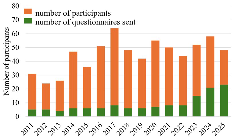
Figure 3Total number of participants per year (orange) and number of questionnaires sent (green).
3.2 Questionnaire setup
3.2.1 General questions
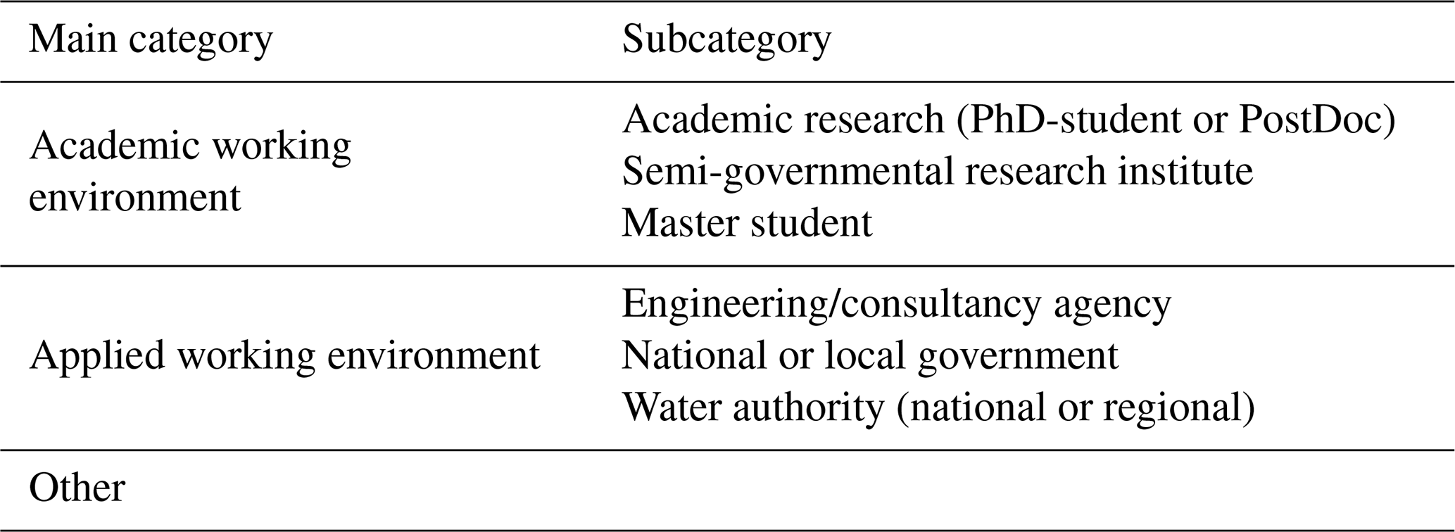
All respondents were asked to indicate the current job category, see Table 1. The subcategories “academic research”, “semi-governmental research institute” and “master student” were grouped as main category “Academic working environment” as it is expected that they are more linked to fundamental academic research than the respondents working at national and local governments and authorities and engineering/consultancy agencies. In the main category “other” fell options such as (secondary school) teacher and NGO's.
Following the question on the current job/study the questionnaire zoomed in on the link between the excursion and their current job (part A), the link between the excursion and the cognitive development (part B) and the future excursion development (part C). For all questions and statements, the participants could select an answer on a likert scale from 1 (fully disagree) to 9 (fully agree), see Table 2.
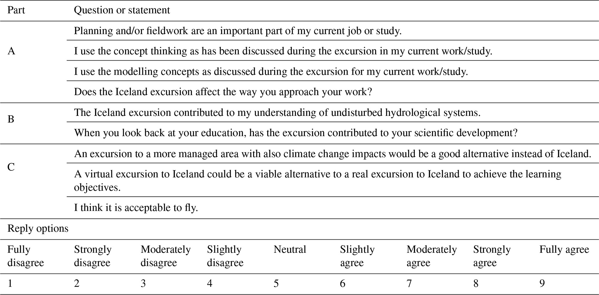
An often heard comment related to field excursions is that geoscience students after graduation hardly have any or minimal options to be in the field (Seibert et al., 2013; Coucledis, 2009). The question can be whether that is true, both in the short run and in the long term. For instance, it might be that junior academics still have fieldwork options, where at a later career stage these activities are replaced by, for example, project management. Furthermore, we aim to explore with these questions whether concept thinking, which is taught during the field excursions by reflecting on how the observed complex reality is conceptualized in hydrological models, settles in the participants' way of thinking or whether this effect fades over time.
An important aspect in choosing Iceland as excursion location is the relatively undisturbed condition of the catchments and the impact of climate change on these catchments. The last group of questions, part C, related to the discussion on (1) reallocating fieldwork to areas which are more heavily managed and are closer to home, (2) replace real excursions by virtual excursions that students can study at their own pace and time and (3) whether it is (still) acceptable to fly a large group to a field location.
3.2.2 COVID-19 years specific questions
During the COVID-19 years 2020 and 2021 it was not allowed to bring students to Iceland. The students instead were asked to study specially prepared professional video material as the virtual excursion. In April 2022 the 2020–2021 population was offered to voluntarily join a real excursion, provided that they were still signed up as student at Wageningen University by that time, and that the excursion fits their schedule. About 50 % was able to and allowed to join. The questions/statements for this group are given in Table 3.
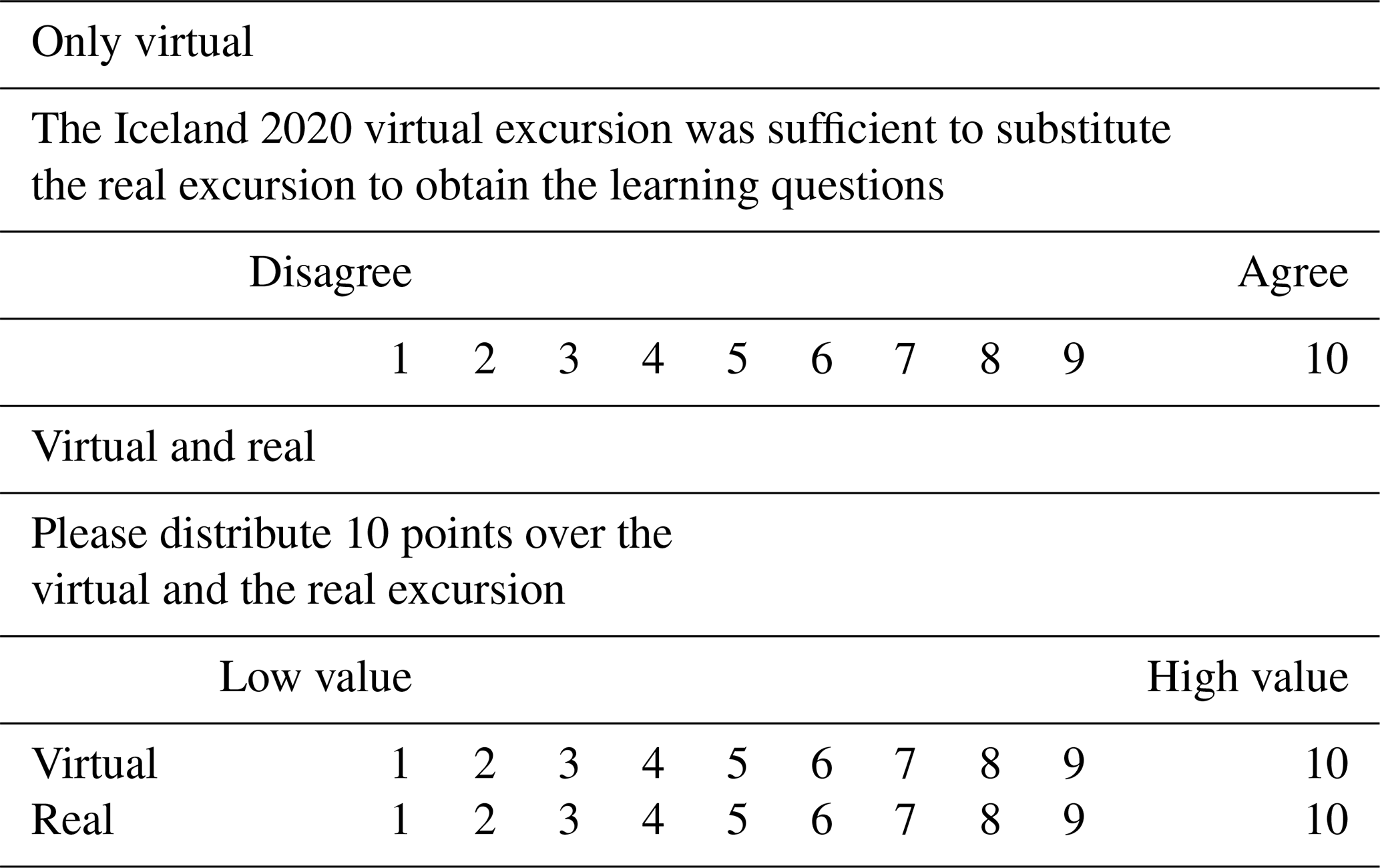
Figure 4 shows the number of questionnaires returned per year as percentage of the number of participants of that specific year and as absolute number of respondents. The total number of completed questionnaires is 104. This is a response rate of 78 % of the questionnaires sent and 15 % of the total number of participants for the period 2011–2025. The number of completed responses for the COVID-19 years 2020 and 2021 was lower than hoped for. Only 40 % of the sent questionnaires was completely filled in. Some students of the 2020 and 2021 cohorts indicated why they had not completed the questionnaire. They stated that they are still so disappointed that they missed such an important educational opportunity due to the COVID-19 restrictions that they no longer want to be reminded of that stressful and frustrating time, and that they therefore do not want to participate in the survey.
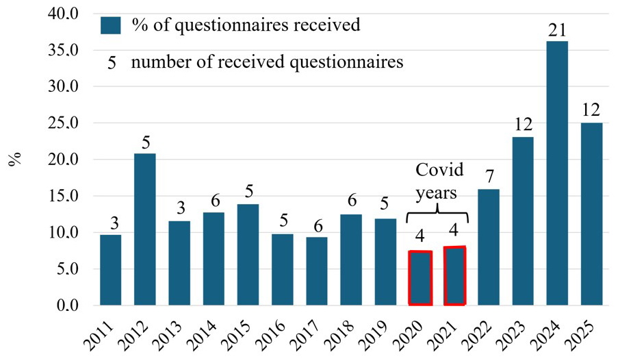
Figure 4Completed questionnaires received from respondents as a percentage of the total number of participants that year and number of returned questionnaires. Total number of completed questionnaires is 104, which is a response rate of 78 %.
The number of completed questionnaires per year for the Pre-COVID-19 period is lower than for the Post-COVID-19 years. The most important limiting factor was the availability of contact information for the older student generations. However, the willingness of the older generations to reply was even greater (85 % of the sent questionnaires was completed), compared to the younger generations (80 %). This again reflects the relatively low responsiveness of the COVID-19 population (40 %). From the eight completed COVID-19 questionnaires, in total four could only reflect on the virtual excursion and four on the virtual and real 2022 excursion.
4.1 Job categories and fieldwork
The Post-COVID-19 population is dominated by respondents who, at the moment they received the questionnaire, still were registered as Master student and working on their Master thesis or doing the Master internship. Figure 5A gives the relative share of responses per category. In total, 50 % of the respondents indicated that they operate in an academic study or work environment (green colour in Fig. 5A and C), with 41 % in the more applied category (blue colour) and 9 % in the “other” category (grey colour). Jobs in “other” category range from secondary school teacher to advisor for renewable energy. This indicates that > 90 % is still active in the Geosciences domain.
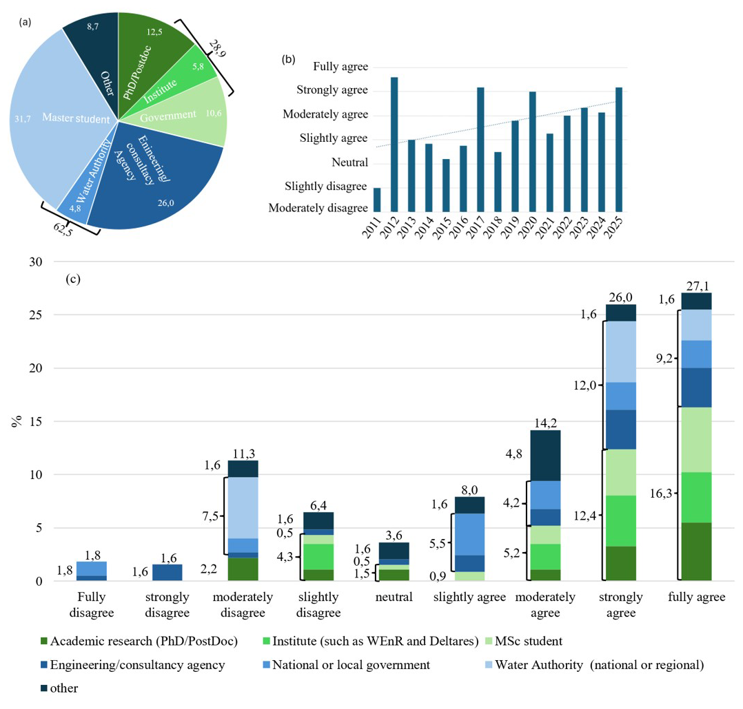
Figure 5Percentage of completed questionnaires (a) per job category, (b) in response to “Planning and/or fieldwork are an important part of my current job or study” relative to the cohorts (years) and (c) relative to the job categories. The numbers show the percentages per main job category (see Table 1) and in total.
A common career path from junior to senior geoscientists often implicates a gradual shift from field activities to indoor activities like management and/or modelling (Madon, 2019). However, on average the response on the statement “Planning and/or fieldwork are an important part of my current job or study” is “moderately agree”, with > 50 % of the respondents even with a response strongly to fully agree. This indicates that field training is important for the majority of the junior and senior geoscientists, even for senior geoscientists with more than 15 years of working experience. We do, however, see a general decline in the relevance of fieldwork when the number of post-graduate years increases, see Fig. 5B. The respondents in the main job category “Academic working environment” gave an average score “moderately to strongly agree” (Fig. 5C).
4.2 Pre- and Post-COVID-19 student cohorts
The Pre-COVID-19 excursion participants already have 5 to 14 years of working experience, where the Post-COVID-19 group is still Master student or early career. This difference in experience had hardly any impact on the response to the questions or statements. In most cases the average response was (almost) identical. The only exceptions are the importance of planning and/or fieldwork, and whether the Iceland excursion did affect their work approach. In both cases the Pre-COVID-19 group is a bit closer to the neutral opinion (average between slightly and moderately agree) in comparison to the Post-COVID-19 group (moderately to strongly agree). This implies that with increasing working experience, it is still recognized that the Iceland excursion has contributed to the scientific development, but that the impact slowly decreases.
4.3 Virtual versus real Iceland excursion
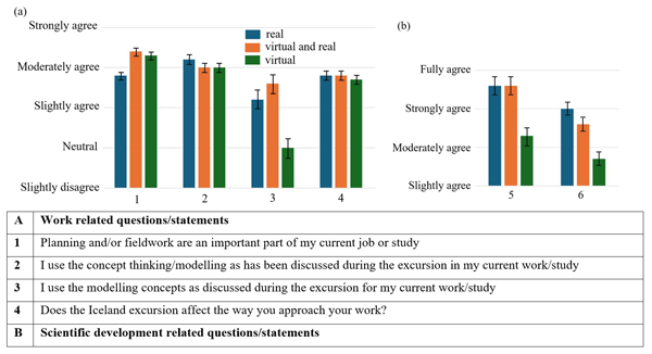
The COVID-19 years did have a detrimental impact in 2020 and 2021on the students in all study cohorts, despite all the efforts of the teaching staff to provide state-of-the-art virtual material. Making (more) use of the virtual material instead of real excursions could resolve issues, such as budget cuts and study planning. It would also enhance the use of relatively new techniques like animations and AI. This brings the question to the table whether the geoscience students see this as a good alternative. Despite the relatively low number of respondents for the COVID-19 years 2020 and 2021, a clear view on virtual versus real excursions is shown in Fig. 6.
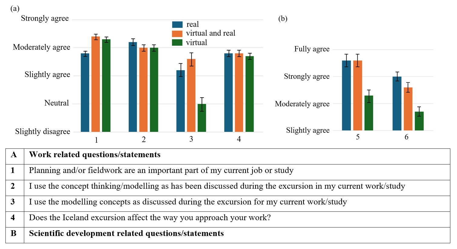
Figure 6Response on (a) work related questions/statements and (b) the scientific development. The numbers on the x axis of the figures relate to the question/statement numbers in the table. The bars in the figures indicate the standard deviation.
The response of the students that only could make use of the virtual excursion material deviates strongly from the students that went to Iceland. They are on average neutral on the question whether the modeling concepts as discussed during the excursion are used for current work or study, where the other responses are slightly positive. The questions/statements in part B show a remarkable difference for the only virtual respondents. Where all respondents that actually went to Iceland for the excursion, either as only option or in 2022 after having the virtual version first, are very positive on the contribution of the excursion to understanding undisturbed hydrological systems as to the impact on their scientific development, whereas a significant lower score is found for those who only studied the virtual equivalent. The understanding of undisturbed systems still falls in the moderately agree range, but the response to scientific development falls back to no more than slightly to moderately agree. This substantial difference is a strong indicator that real excursion made a long lasting experience for all participants.
The strongest indication is given in the statement related to the virtual versus real excursion. The respondents that only participated in the real excursion strongly to fully disagree with having a virtual excursion as alternative. The respondents that only studied the virtual excursion were more nuanced with a response as moderately to strongly disagree, but the virtual and then real excursion respondents were very strong in preferring the real excursion. This is also reflected in the distribution of 10 points over the virtual and real excursion (see Table 3). The real excursion receives 8.9 points and the virtual excursion only 1.1 point! In other words, a virtual excursion, regardless of how well it is set up, according to the end-users i.e., the Master students, cannot be an adequate substitution for a real excursion.
Reflection from participant: “I think you can learn a lot in a classroom, but an excursion makes you remember”.
4.4 Undisturbed hydrological systems versus a more managed area
Another strong contrast between the respondents that participated in the real excursion and the respondents that only had the virtual option is the feedback on alternatives to a more managed area (Fig. 7). Where others disagree on this alternative, there the virtual excursion group remains neutral. This indicates that the impact of being in an undisturbed hydrological system and seeing the landscape and river through their own geoscientific eyes is very strong and long lasting. The group that had the virtual excursion as the only option did not have that strong impact of being in Iceland and therefore did not have a strong opinion on going to an alternative location. The virtual group is also more firm on the acceptance of flying for the excursion (Virtual 7.7: moderately to strongly agree; rest: 6.6: slightly to moderately agree). This shows that the students who did not get the chance to fly view flying all the more as necessary to be able to go to Iceland.
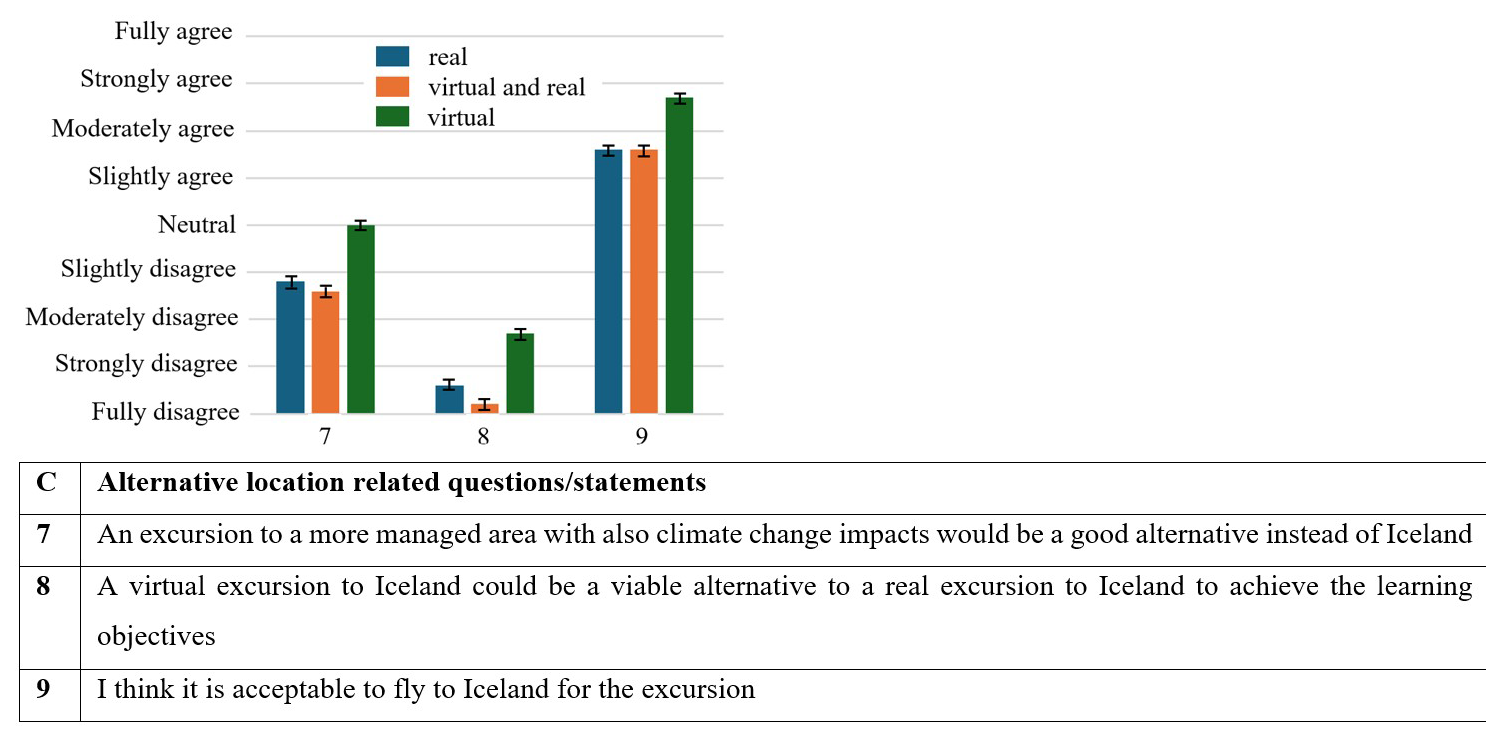
Geoscience is all about understanding processes in often complex systems. Often these processes are hidden below a sauce of human influences. Even though most graduates will work in a heavily managed and artificial landscape, understanding the main processes in an undisturbed systems seems crucial. All respondents think that the Iceland excursion strongly contributed to their understanding of undisturbed hydrological systems (strongly to fully agree).
Of course it is a bit farfetched to think of Iceland as fully undisturbed and natural, but the forces of the earth with its volcanoes, ocean floor spreading and mantle plume and relatively unmanaged rivers make it a special place. Where else can you find, on a small piece of land with a low population density, braided rivers, meandering rivers, glacier melt due to climate change, typical groundwater driven rivers, runoff rivers and a precipitation distribution ranging a whole order of magnitude (400–4000 mm yr−1)? Apparently being in such an impressive landscape makes that even in the long term it helps to fully grasp the processes.
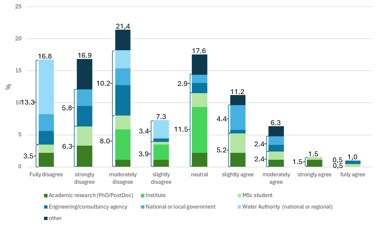
Figure 8Response on “An excursion to a more intensely managed area with also climate change impacts would be a good alternative instead of Iceland”.
An interesting question can be whether the opinion on the effectiveness of being in an undisturbed hydrological system shifts over the years and/or whether the opinion is dependent on the current job or job category. Figure 8 shows the response on the question whether a more managed area could be a good alternative. The majority disagrees on that alternative, but there is clearly a nuance visible. The average for the main job category “Academic working environment” falls in the range between neutral and slightly disagree, where the response in the main job category “Applied working environment” lands on average in the range slightly to moderately disagree. In total one third of the respondents fully disagree on the thought of going to a more intensively managed area. This rather strong opinion against the thought of having an excursion to a more intensively managed area, even when this area is also exemplary to the impact of climate change, strengthens the thought that excursions for geoscientists should predominantly aim at processes in a field setting without much management practices disturbing the view.
An often heard criticism is that climate scientists travel the world for meetings and conferences and as such also contribute to climate change. The same critical note could hold for the education of new geoscientists with a solid understanding of the impact of climate change. However, only 13 % of the respondents indicate that they do not think it is acceptable to fly to Iceland for the excursion (moderately disagree). Another 13 % has a neutral position on this. The remaining 74 % is positive on the thought of flying to Iceland (on average strongly agree). This seems to support the suggestion that you should be careful and selective in relation to flying, but that being in the field to see and experience makes the difference.
Reflection from participant: “The excursion captures the very essence of what I believe studying is about. Being curious, feeling passionate, and loving the process of learning”.
The questionnaire was distributed among the excursion participants in 2025. For some participants, the excursion was already many years ago. Reflecting on this excursion in 2025 also implies that students from the early years look back at the excursion through the 2025 hour glass. This implies that they might have shifted in opinion on for instance flying. The moral compass on flying has slowly but certainly changed over the last decades. Pratt and Tolkach (2022) showed that in the decision making process of flying the focus on ethical dilemmas increased. In the touristic sector the awareness-attitude-behavior gap still hold for many, but in the academic educational society the moral compass related to flying is an integral component in the decision making. The overall averaged opinion of the survey respondents is now that they moderately agree on the question whether it is acceptable to fly to an excursion location, with no trend over the years of participation. A reason for agreement might also be that there is no reasonable more environment friendly option to get to Iceland from the European mainland.
All students that reflected on the virtual excursion – either with or without a real excursion in 2022 – did study the virtual excursion materials during COVID-19 years. As indicated by one of the participants of these years: “Although I was grateful to the teachers for their effort to offer a virtual excursion, the combination with a lockdown was devastating for me”. This combination of factors may have cast the virtual excursion in a negative light from the start. However, when COVID-19 restrictions were lifted in the spring of 2022 and students were allowed to return to campus, the opinion was still quite positive. That changed when the students also took a real excursion. Then they realized how much more the real excursion offers compared to the virtual equivalent.
Similar to the findings of Barton (2020), our survey revealed a substantial reduction of learning outcomes when only virtual materials have been studied that typically are taught in the field. Geoscience students need laboratory and field experiences to stimulate hypotheses testing and theory development (Fischer and Tatomir, 2022). Our Iceland excursion gives similar results, by showing that virtual educational materials can be an extra tool, but not a replacement for a real excursion. As Li et al. (2022) already showed: virtual attendance is disadvantageous to teaching and learning, and transferable skills like teamwork and communication are compromised due to a reduction in social interaction.
In compiling the questionnaire, an attempt was made to formulate the questions and statement and arrange them in such an order that they do not put words in the mouths of the respondents. Nevertheless, it is possible that the participants wanted to give the teachers a boost to ensure the continuation of the excursion. This could affect the reliability and representativeness of the result. Given the very high expectations that the participants always have prior to the excursion – they have been looking forward for years to the prospect of being allowed to join the excursion – the chance that they are not expressing their own opinion is fairly low. This also applies to the interpretation of the survey. All authors are teachers on this excursion and therefore feel strongly connected to the location and content. This can influence the perception and interpretation of the survey responses. To limit this bias, the survey was kept anonymous, and the results were examined from various different angles and scrutinized for trends and opinions. Nevertheless, there might be a bias that only the participants with a strong (either positive or negative) opinion responded.
As already indicated in the introduction, there have already been many researchers have examined the relationship between virtual versus real education and student satisfaction and development (Barton, 2020; Boyle et al., 2007; Fisher and Tatomir, 2022; Li et al. 2022; Pugsley et al., 2022; Seibert et al., 2013). All their studies were initiated based on the researchers' perception and may therefore have also taken on the tone of these researchers. Researchers who hold fieldwork in high regard would like to see participants endorse this view (Spicer and Stratford, 2001). However, the likelihood of a distorted picture is small, because it is precisely the future geoscientists who determine the tone of the answers, thereby demonstrating the importance of fieldwork is undeniable.
In the academic world, the digital tools and video facilities to produce high-quality digital teaching materials are getting better and better. These digital teaching materials have undeniably a positive impact on educating future geoscientists. These tools open the door to transfer excursions to digital equivalents. However, a survey among Master students that participated in an excursion to Iceland clearly shows that the digital materials do have added value, but not as a replacement for the real excursion. This confirms findings by previous studies (Spicer and Stratford, 2001; Seifan et al., 2020). This added value of real excursions is demonstrated best by the difference in the contribution to the scientific development. Regardless of the year of participation, the entire group that went to Iceland is very positive about the excursion in relation to scientific development, while the group that only took the virtual excursion is considerably less positive. It is felt that excursions enhance the degree of relatedness the participants feel with their fellow students and their teachers. Also the intrinsic motivation during the whole course is greater, even when the classroom activities are aiming at topics such as modelling and literature review.
The importance of field training is acknowledged by as well the junior as the senior geoscientists. A multiple day excursion to an undisturbed country like Iceland, even when that implies flying to the excursion location, is strongly favoured above an excursion to a more managed area.
This leads to the overall conclusion that all the experiences during excursions facilitate learning that may not be possible in a more tradition classroom setting and/or by replacing the excursions by an digital/online equivalent.
A course related to processes in catchments in various hydrogeologic settings, with a strong link to (impact of) climate change strongly benefits from a multiple day excursion to an area where all the theory comes to life. Therefore it was decided to setup an excursion to an area that can be seen as the perfect breeding ground for hydrologists: Iceland.
Iceland is unique from a hydro(geo)logical and climatological perspective. It's the only location on Earth where an oceanic ridge is coinciding with a hotspot (Wolfe et al., 1997). This hotspot is pushing the Mid-Atlantic ridge up to well above sea level. Figure A1A gives the digital elevation model (adapted from Hydrosheds, 2025), with as highest point inactive volcano Hvannadalshnjúkur (2110 m a.s.l.). Figure A1B shows a simplified geological map (adapted from Kortagluggi, 2025). The Mid-Atlantic Ridge is clearly visible (pink). Sea floor spreading is on average 1 cm yr−1 in both directions (ref). The oldest rock formations (blue coloured regions on the geological map) are approximately 20 million years old.
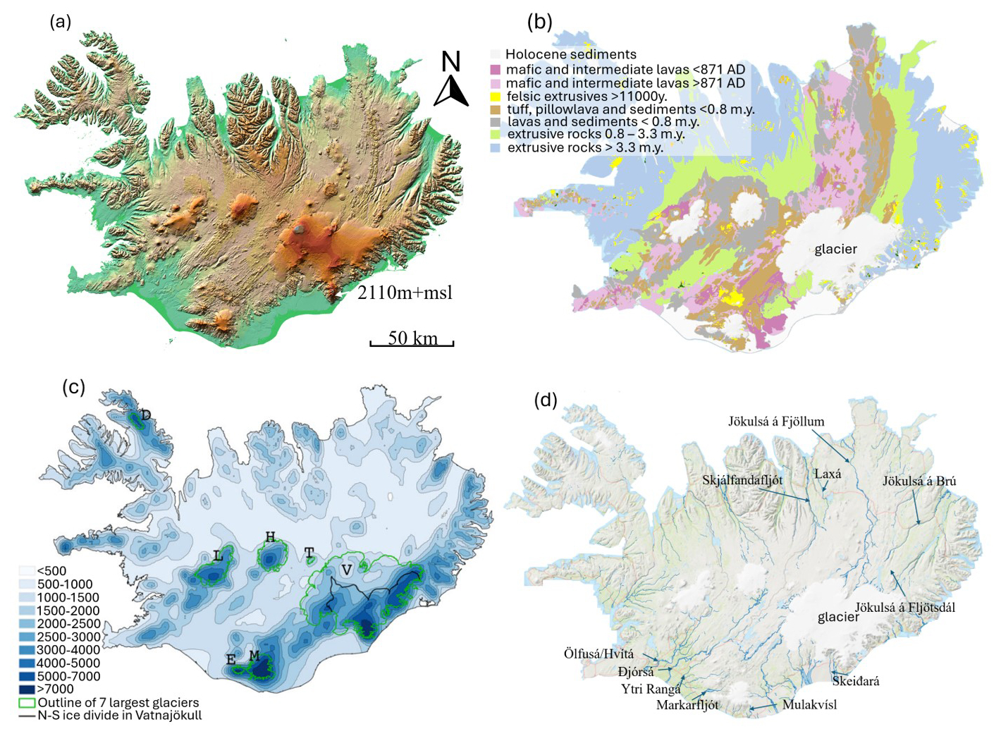
Figure A1Iceland, with (A) Conditioned digital elevation model (adapted from Hydrosheds, 2025), (B) Geological map (adapted from Kortagluggi), (C) average annual precipitation (adapted from Jóhannesson et al., 2007) (V = Vatnajökull, L = Langjökull, H = Hofsjökull, M = Mýrdalsjökull, E = Eyjafjallajökull, T = Tungnafellsjökull, D = Drangajökull) and (D) main rivers (adapted from Kortagluggi, 2025).
Iceland has a predominantly subpolar oceanic climate (Köppen Cfc) in the coastal zones and a tundra climate (ET) in the highlands. The North Atlantic current is a warm Gulf stream that flows along the southern and western coasts, bringing mild Atlantic air to these regions. North and northeast are under influence of the colder Arctic air. Figure A1C gives the precipitation distribution. The profound orography in combination with the warm ocean current in the southwest results in a spatially highly variable precipitation distribution. The southwest is considered to be the wettest side of Iceland and the northeast the dry side, ranging from > 7000 to < 500 mm yr−1. The volcanoes and glaciers form a barrier for the clouds coming in from the south. Rögnvaldsson et al. (2007) showed that the mountains constitute about 40 % increase in precipitation over Iceland. They also cause a drying in the highlands north of the Vatnajökull ice cap and north of the two large ice caps in central Iceland (Langjökull and Hofsjökull).
Over 90 % of the country consist of mafic (basaltic) lavas (Fig. A1B). The young (Holocene – Late-Pleistocene) formations are considered to have a rather high hydraulic conductivity (Dijksma et al., 2025), which makes them good aquifers. The older formations (Tertiary – Early-Pleistocene) have much lower hydraulic conductivity, also because of the numerous dikes intersect more permeable layers. On the highest elevations, predominantly volcanoes, the precipitation falls as snow (Crochet et al., 2007), creating large glaciers (see Fig. A1B and C). The high precipitation surplus and glacier melt requires a dense natural drainage pattern (see Fig. A1D). The largest rivers in the southwest, such as the Đjórsá with > 1600 mm yr−1, discharge annually twice as much water as the largest rivers in the northeast, such as the Jökulsá á Fjöllum, with ∼ 850 mm yr−1 (Jónsdóttir, 2008).
The ice caps and glaciers of Iceland are heavily affected by climate change (Flowers et al., 2005; Guđmundsson et al., 2011; Halbertsma, 2025). A rapidly growing part of the ice is below the equilibrium line by now, causing an increase in glacier melt and related river discharge. These rapid changes are clearly visible in the field and in the interannual hydrographs. The rivers downstream of the large ice caps receive significantly more melt water than in the year before climate change kicked in, and the rivers downstream of the small glaciers are losing their glacier signal (meltwater during summer) because only a small portion of the glacier is left.
The large differences in precipitation, the absence of soils in large parts of the country, the large differences in hydraulic conductivity in the subsurface in combination with glacier melt results in groundwater fed rivers, direct runoff rivers, glacier rivers and combined rivers. Iceland is also known for is large percentage of renewable energy through geothermal energy and hydropower. The hydropower dams can predominantly be found in the relatively densely populated southwest segment of the country.
Anonymised data is provided in the separate supplement file.
The supplement related to this article is available online at https://doi.org/10.5194/gc-9-437-2026-supplement.
RD designed the survey, analysed the data from the survey and wrote the draft of the manuscript. All authors participated in the setup of the survey and edited the manuscript.
The contact author has declared that none of the authors has any competing interests.
Participation to the survey was voluntarily. The goals of the study were clearly stated in the introduction of the questionnaire. Data were collected following data protection guidelines and approved software (Qualtrics), and treated anonymously.
Publisher's note: Copernicus Publications remains neutral with regard to jurisdictional claims made in the text, published maps, institutional affiliations, or any other geographical representation in this paper. The authors bear the ultimate responsibility for providing appropriate place names. Views expressed in the text are those of the authors and do not necessarily reflect the views of the publisher.
We thank Wageningen University for their willingness to provide financial support for the Iceland Excursion as part of the Catchment and Climate Hydrology course and the (former) Master students for filling in the questionnaire.
This paper was edited by Caitlyn Hall and reviewed by John W. Geissman and one anonymous referee.
Arthurs, L.: Bringing the field to students during COVID-19 and beyond, GSA Today, 31, 28–29, https://doi.org/10.1130/GSATG478GW.1, 2021
Barton, D. C.: Impacts of the COVID-19 pandemic on field instruction and remote teaching alternatives: Results from a survey of instructors, Ecol. Evol., 10, 12499–12507, https://doi.org/10.1002/ece3.6628, 2020
Bond, C. E., Pugsley, J. H., Kedar, L., Ledingham, S. R., Skupinska, M. Z., Gluzinski, T. K., and Boath, M. L.: Learning outcomes, learning support, and cohort cohesion on a virtual field trip: an analysis of student and staff perceptions, Geosci. Commun., 5, 307–323, https://doi.org/10.5194/gc-5-307-2022, 2022.
Boyle, A., Maguire, S., Martin, A., Milsom, C., Nash, R., Rawlinson, S., Turner, A., Wurthmann, S., and Conchie, S.: Fieldwork is good: The student perception and the affective domain, J. Geogr. Higher Educ., 31, 299–317, https://doi.org/10.1080/03098260601063628, 2007
Chitty, E. G. and Hesp, P. A.: The value of field studies in earth and environmental sciences: a review, Nat. Sci. Educ., 53, e70004, https://doi.org/10.1002/nse2.70004, 2024.
Coucledis, H.: Rethinking time geography in the information age, Environ. Plann., 41, 1556–1575, 2009.
Crochet, P., Jóhannesson, T., Jónsson, T., Sigurđsson, O., Björnsson, H., Pálsson, F., and Barstad, I.: Estimating the spatial distribution of precipitation in Iceland using a linear model of orographic precipitation, J. Hydrometeorol., 8, 1285–1306, https://doi.org/10.1175/2007JHM795.1, 2007.
Dickerson, D. L., Dawkins, K. R., and Annetta, L.: Scientific fieldwork: An opportunity for pedagogical-content knowledge development, J. Geosci. Educ., 55, 371–376, https://doi.org/10.5408/1089-9995-55.5.371, 2007.
Dijksma, R, Bense, V. F., Zweers, E., Avis, L., and Vander Ploeg, M. J.: Hydrological characteristics of columnar basalt aquifers: measuring and modeling Skaftafellsheidi, Iceland, Geosciences, 15, 160, https://doi.org/10.3390/geosciences15050160, 2025.
Dunphy, A. and Spellman, G.: Geography fieldwork, fieldwork value and learning styles, International Research in Geographical and Environmental Education, 18, 19–28, https://doi.org/10.1080/10382040802591522, 2009.
Fedesco, H. N., Cavin, D. and Henares, R.: Field-based learning in higher education, J. Scholarship of Teaching and Learning, 20, 65–84, https://doi.org/10.14434/josotl.v20i1.24877, 2020.
Fischer, B. M. C. and Tatomir, A.: A snapshot sample on how COVID-19 impacted and holds up a mirror to European water education, Geosci. Commun., 5, 261–274, https://doi.org/10.5194/gc-5-261-2022, 2022.
Flowers, G. E., Marshall, S. J., Björnsson, H., and Clarke, G. K. C.: Sensitivity of Vatnajökull ice cap hydrology and dynamics to climate warming over the next 2 centuries, J. Geophys. Res., 110, https://doi.org/10.1029/2004JF000200, 2005.
Fuller, I., Gaskin, S., and Scott, I.: Student perceptions of geography and environmental science fieldwork in the light of restricted access to the field, caused by foot and mouth disease in the UK in 2001, J. Geogr. Higher Educ., 27, 79–102, https://doi.org/10.1080/0309826032000062487, 2003.
Guđmundsson, S., Björnsson, H., Magnússon, E., Berthier, E., Pálsson, F., Guđmundsson, M. T., Högnadóttir, T., and Dall, J.: Response of Eyjafjallajökull, Torfajökull and Tindfjallajökull ice caps in Iceland to regional warming, deduced by remote sensing, Polar Res., 30, https://doi.org/10.3402/polar.v30i0.7282, 2011.
Halbertsma, J.: Predicting future retreat of the Breiđamerjökull glacier under influence of proglacial lake Jokülsárlón, Bachelor thesis, Wageningen University, 35 pp., 2025.
Hoyer, L. and Hastie, W. W.: Geoscience undergraduate students' perceptions of how field work and practical skills influence their conceptual understanding and subject interest, J. Geosci. Educ., 71, 158–176, https://doi.org/10.1080/10899995.2022.2110630, 2022.
Hydroshed.org: https://www.hydrosheds.org, last access: 16 January 2026.
Jóhannesson, T., Ađalgeirsdóttir, G., Björnsson, H., Crochet, P., Elíasson, E. B., Guđmudsson, S., Jónsdóttir, J. F., Ólafsson, H., Pálsson, F., Rögnvaldsson, Ó., Sigurđsson, O., Snorrasson, Á, Blöndal Sveinsson, Ó. G., and Thorsteinsson, T.: Effect of climate change on hydrology and hydro-resources in Iceland, National Energy Authority, report no. OS-2007/011, 91 pp., ISBN 978-9979-68-224-0, 2007.
Jones, J. B. and Washko, S.: More than fun in the sun: The pedagogy of field trips improves student learning in higher education, J. Geosci. Educ., 70, 3, 292–305, https://doi.org/10.1080/10899995.2021.1984176, 2022.
Jónsdóttir, J. F.: A runoff map based on numerically simulated precipitation and a projection of future runoff in Iceland, Hydrol. Sci. J., 53, 100–111, https://doi.org/10.1623/hysj.53.1.100, 2008.
Kern, E. L. and Carpenter, J. R.: Effect of field activities on student learning, J. Geol. Educ., 34, 180–183, https://doi.org/10.5408/0022-1368-34.3.180, 1986.
Kortagluggi: https://www.kortagluggi.is, last access: 1 October 2026.
Li, Y., Krause, S., McLendon, A. and Jo, I.: Teaching a geography field methods course amid the COVID-19 pandemic: Reflections and lessons learned, J. Geogr. Higher Educ., 47, 339–348, https://doi.org/10.1080/03098265.2022.2041571, 2022.
Madon, M.: Geoscience capacity development in the petroleum industry: challenges and opportunities, Warta Geologi, 45, 412–421, 2019.
Peace, A. L., Gabriel, J. J., and Eyles, C.: Geoscience fieldwork in the age of COVID-19 and beyond: Commentary on the development of a virtual geological field trip to whitefish falls, Ontario, Canada, Geosciences, 11, 489, https://doi.org/10.3390/geosciences11120489, 2021.
Pratt, S. and Tolkach, D.: Ethical-decision making of “Flights to Nowhere” passengers in the COVID-19 and climate change era, Curr. Issues Tour., 26, 735–751, https://doi.org/10.1080/13683500.2022.2038090, 2022.
Pugsley, J. H., Howell, J. A., Hartley, A., Buckley, S. J., Brackenridge, R., Schofield, N., Maxwell, G., Chmielewska, M., Ringdal, K., Naumann, N., and Vanbiervliet, J.: Virtual field trips utilizing virtual outcrop: construction, delivery and implications for the future, Geosci. Commun., 5, 227–249, https://doi.org/10.5194/gc-5-227-2022, 2022.
Pyle, E. J.: The evaluation of field course experiences: A framework for development, improvement and reporting, Field geology education: historical perspectives and modern approaches, Geol. Soc. Am., 341–356, https://doi.org/10.1130/2009.2461(26), 2009.
Rögnvaldsson, Ó., Jónsdóttir, J. F., and Ólafsson, H.: Numerical simulations of precipitation in the complex terrain of Iceland – Comparison with glaciological and hydrological data, Meteorol. Z., 16, 71–85, https://doi.org/10.1127/0941-2948/2007/0174, 2007.
Scott, I., Fuller, I., and Gaskin, S.: Life without fieldwork: some lecturers' perceptions of geography and environmental science fieldwork, J. Geogr. Higher Educ., 30, 161–171, https://doi.org/10.1080/03098260500499832, 2006.
Scott, I., Goulder, R., Wheeler, P., Scott, L., Tobin, M. L. and Marsham, S.: The value of fieldwork in life and environmental sciences in the context of higher education: A case study in learning about biodiversity, J. Sci. Educ. Technol., 21, 11–21, https://doi.org/10.1007/s10956-010-9276-x, 2012.
SDI Iceland: Maps of Iceland, https://kort.gis.is, last access: 14 April 2026.
Seibert, J., Uhlenbrook, S., and Wagener, T.: Preface “Hydrology education in a changing world”, Hydrol. Earth. Syst. Sci., 17, 1393–1399, https://doi.org/10.5194/hess-17-1393-2013, 2013.
Seifan, M., Dada, O. D., and Berenjian, A.: The effect of real and virtual construction field trips on students' perception and career aspiration, Sustainability, 12, 1200, https://doi.org/10.3390/su12031200, 2020.
Spicer, J. I. and Stratford, J.: Student perceptions of a virtual field trip to replace a real field trip, J. Comput. Assist. Learn., 17, 345–354, https://doi.org/10.1046/j.0266-4909.2001.00191.x, 2001.
Whitney, M. M.: Icelandic riverine freshwater distribution, offshore export, and along shelf connectivity, Estuar. Coast. Shelf S., 319, https://doi.org/10.1016/j.ecss.2025.109266, 2025.
Wolfe, C. J., Bjarnason, I. T., VanDecar, J. C., and Solomon, S. C.: Seismic structure of the Iceland mantle plume, Nature, 385, 245–247, https://doi.org/10.1038/385245a0, 1997.
Zelensky, W.: The geographer as voyeur, Geogr. Rev., 91, 1–9, https://doi.org/10.2307/3250798, 2001.