the Creative Commons Attribution 4.0 License.
the Creative Commons Attribution 4.0 License.
 | 07 Jul 2026
Including cultural context improves communication outcomes for quaternary geoheritage: evidence from southeast Arabia
Kenta Sayama
Husam Al Rawahi
Robert A. Fahey
Heather Viles
Adrian G. Parker
Effective science communication plays a crucial role in enhancing public understanding of Quaternary science. One promising strategy involves highlighting the interconnectedness of Quaternary sites, archaeology, and human culture. Despite the recent increased focus on science communication within the geosciences, the significance and effectiveness of highlighting such geocultural connections in communicating about Quaternary geoheritage sites have rarely been examined experimentally.
This study evaluates the effectiveness of including geocultural context in educational videos for communicating the significance of Quaternary geoheritage sites in United Arab Emirates (UAE) and Oman. An online experiment was conducted to evaluate the effects of videos produced with input from academics, museum professionals, and heritage administrators from the region. The study compares the impact of two different 9 min videos developed in collaboration with academics, museum professionals, and heritage administrators from the region – one emphasising the geocultural context, and the other focusing solely on Quaternary science –. The impacts on participants' knowledge, interest, and perception of Quaternary geoheritage sites were assessed.
The videos enhanced participants' self-reported knowledge of Quaternary geoheritage sites and increased their interest. Although the statistical results remain tempered by uncertainty, the overall pattern suggests that geocultural framing can foster a stronger and more durable sense of the importance of conserving Quaternary geoheritage, especially among people with less prior knowledge of such sites. The number of participants of this study is small and demographically limited to highly educated, relatively young adults with pro-nature attitudes, but this study demonstrates the value of integrating geocultural context in communicating the importance of Quaternary science and raising awareness of Quaternary geoheritage.
- Article
(3504 KB) - Full-text XML
-
Supplement
(1082 KB) - BibTeX
- EndNote


Quaternary science holds significant relevance for society, with implications for climate change, sea level oscillations, coastal erosion, geohazards, historical biodiversity, and human evolution (Elias, 2007). Quaternary processes have shaped numerous distinctive landscapes, some of which have been protected internationally. According to Boylan (2008), 17 % of all World Heritage Sites characterised by geological features predominantly represent Quaternary features, including karstic landscapes (e.g. Plitvice, Croatia), deserts (Lut Desert, Iran), or volcanoes (Hawaii Volcanoes National Park, USA), despite this period only representing 0.057 % of Earth's history.
Many geological heritage sites, or geoheritage sites, have been protected (Chylińska, 2019) and visited (Štrba, 2019) primarily for their aesthetic appeal rather than their scientific significance or appreciation. Quaternary sites are no exception to this trend. In both the World Heritage List (Boylan, 2008) and the Global Geopark Network (Brilha, 2018), Quaternary sites predominantly feature glacial, karstic, or volcanic formations, aligning with the classic definition of natural beauty (Churchward et al., 2013; Mitchell, 2013). Consequently, the communication and promotion of geoheritage sites, particularly concerning their scientific and societal importance, have emerged as crucial agendas (Stewart and Nield, 2013; Gordon et al., 2018).
Recognising the cultural significance of Quaternary sites presents a potential avenue to enhance their appreciation among the general public. The concept of geocultural heritage (Sayama et al., 2022; Reynard and Giusti, 2018; Kubalíková et al., 2020) emphasises the interconnections between geological and geomorphological features and human culture, providing an alternative way for audiences to relate to these environments. However, the practical efficacy of the geocultural concept in interpreting and promoting Quaternary geoheritage sites is little studied and lacks quantitative analysis. This study addresses this gap by using documentary-style videos to present Quaternary geoheritage sites in southeast Arabia (i.e. the UAE and Oman). It aims to evaluate the effectiveness of geocultural framing in science communication and to generate empirical evidence to inform strategies for communicating Quaternary geoheritage.
1.1 Geoheritage and cultural heritage
As components of landscapes, geoheritage sites often hold symbolic and spiritual meaning, reflected in religious traditions that attribute sacred status to features such as rocks and caves (Kiernan, 2015). Geological processes and events are embedded in cultural memory through oral traditions and place names, which record volcanic eruptions, earthquakes, and tsunamis and, in some cases, contribute to long-term risk awareness and disaster preparedness (Ludwin et al., 2007; King and Goff, 2010; Fepuleai et al., 2017; Sousa et al., 2010; Planas-Batlle et al., 2023; Fontanella Pisa, 2024; Isoda et al., 2019). In addition, geoheritage sites can provide essential contextual information for archaeological research by reconstructing palaeogeographic settings and documenting past human–environment interactions (Panizza and Piacente, 2009; Melelli et al., 2016; Coratza and Hobléa, 2018; Fairchild and McMillan, 2007). Geological materials and landforms have also been widely used in the construction of settlements, infrastructure, and cities, forming the basis of urban geoheritage and offering opportunities to connect geosciences with everyday human experience (Boukhchim et al., 2018; Coratza et al., 2016; Kubalíková et al., 2020; Pica et al., 2018). Together, these cultural dimensions highlight the need for holistic approaches to geoheritage conservation and communication that integrate scientific, cultural, and societal perspectives.
1.2 Quaternary geoheritage and its cultural dimension
Quaternary geoheritage sites encompass geological/geomorphological sites whose primary heritage values originate in the Quaternary period (Sayama, 2024). This concept represents a broader interpretation of geomorphosites (sensu Reynard et al., 2009), which defines aesthetic characteristics as one key (but not sole) attributes. In general, Quaternary geoheritage sites demonstrate three main characteristics (Reynard, 2009; Sayama, 2024). Firstly, many Quaternary geoheritage sites are dynamic, as they are strongly influenced by ongoing earth surface processes. Secondly, these sites can exist at various scales, ranging from those covering entire landscapes, such as alluvial plains, to smaller individual features such as single rocks or crystals. Finally, many Quaternary geoheritage sites exhibit strong connections with human culture, encompassing archaeological, historical, architectural, and other dimensions. These sites were formed, are forming, or will be formed, concurrently with human history. With this overlap in natural and human history, Quaternary geoheritage sites can provide geoarchaeological records of the human-environment interactions over time and reveal human impacts on this nature-culture relationship. Moreover, Quaternary geoheritage sites have inspired creative ingenuity in art and cultural traditions, as exemplified by the religious and artistic significance of Mount Fuji, Japan (Oguchi and Oguchi, 2010; Chakraborty and Jones, 2018), or the importance of Holocene meteorite impact craters in Australia for Aboriginal Dreamtime stories, some with an oral history dating back more than 4500 years (Hamacher and Goldsmith, 2013). Given these distinctions, many geoheritage studies (Moradi et al., 2021; Pereira and Pereira, 2010; Pereira et al., 2007; Erhartič, 2010) have treated Quaternary sites (or geomorphosites) separately from older geoheritage sites, particularly in site evaluations (Santos et al., 2020; Mucivuna et al., 2022).
1.3 Science communication on geoheritage and geosciences
The lack of appreciation of geosciences and geoheritage has been documented from various perspectives. For example, on social media, the hashtag “geology” has been used approximately 80 % less frequently than “physics”, “biology”, or “chemistry” (Zawacki et al., 2022). Even when the media features geosciences, Stewart and Nield (2013) found that topics broadcast on British television were usually limited to a few popular domains, including palaeontology, volcanology, and seismology, with a range of featured Quaternary topics mainly related to geohazards or archaeology. These findings highlight room for improvement in the public recognition of geosciences, including Quaternary science.
Effective communication strategies have garnered attention and recognition as potential solutions to this apparent “detachment” (Stewart and Nield, 2013) from geosciences. As described by Illingworth et al. (2018) and Rodrigues et al. (2023), geoscience communication is still at its infancy as an academic field. The non-specialists' difficulty in understanding deep time (Bowring, 2014; Warmold, 2017; Trend, 2001), unfamiliarity with technical jargon (Ren et al., 2013; Kortz et al., 2017), and the global lack of geosciences education in schools (Melendez et al., 2007; Reis et al., 2014; Subedi et al., 2020), have been identified as primary hurdles to wider appreciation and understanding of geoheritage sites and geosciences.
Over the last 10–15 years, various creative approaches have been developed to enhance geoscience communication, including information panels (Bruno and Wallace, 2019; Pasquaré Mariotto and Venturini, 2017), 3D models/virtual site visits (Dolphin et al., 2019; Hoblea et al., 2014), animations (Lansigu et al., 2014), poetry (Illingworth, 2023), mobile applications (Cayla, 2014), soundscapes (Connor and Maculuve, 2025) and dance (Matias et al., 2020). Regardless of the approach, many studies share the common theme of storytelling (Migoń and Pijet-Migoń, 2017; Van Loon et al., 2020; Matias et al., 2020; Illingworth, 2023; Stewart and Nield, 2013), praising its utility in delivering information in ways that connects with the audience cognitively and emotionally (Dahlstrom and Scheufele, 2018).
In analysing these initiatives, only a few studies have conducted quantitative or mixed-method assessments of the impacts of interventions. One of the few examples is Mani et al. (2016), whose study found a 12 %–17 % improvement in participants' knowledge on volcanic hazard after playing a video game on the topic. Such impact assessments demonstrate the potential of geoscience communication, but these studies usually evaluate short-term effects, from data collected immediately after interventions. Given the goal of geoscience communication to increase public discussion and sustained attention to geosciences (Illingworth et al., 2018), longer-term assessments are necessary to provide a more comprehensive understanding of the communication outcomes.
1.4 Science communication studies using online video
Videos have been used in scientific communication studies across various fields, including ecology (Ruzi et al., 2021), climate science (Ettinger et al., 2021), and medical sciences (Dudley et al., 2023). Videos offer several advantages as a mode of communication. Delivering information in person or through videos and other visual media outperformed written text in 15 studies (Dudley et al., 2023). Videos facilitate enhanced emotional engagement of the audience (Yadav et al., 2011) and easier comprehension through the combination of narration and images (Moreno and Mayer, 1999).
Recognising the importance of videos in science communication, studies have provided guidelines for developing effective videos. Desired features included visual attractiveness, brevity, engaging content, and consideration of the audience needs and expectations (León and Bourk, 2018). The optimal length of educational videos has been identified as around 6–9 min (Guo et al., 2014; Kaim et al., 2020; Manasrah et al., 2021). Guo et al. (2014), found that when videos exceeded 9 min, viewers are only focused on the content for less than 50 % of the total duration.
In experimental settings, videos are commonly used to assess changes in opinions or attitudes after viewing (Kaim et al., 2020; Dunn et al., 2020), as well as to compare the effectiveness of different science communication strategies. For example, Ettinger et al. (2021) used short videos to compare differences in viewers' reactions to videos with a pessimistic or an optimistic outlook on the trajectory of climate change. In geoscience communication, however, the utility of videos has seldom been studied quantitatively. One notable exception is Zawacki et al. (2022), who analysed the relative success of 48 geoscientific Tik Tok videos. This study found that while the most viewed videos were short clips related to news events; it was the longer videos, with fewer views, that garnered the most user engagement through comments and “likes”. Given the demonstrated efficacy of videos in communicating science and technology, there are further opportunities to test their applicability for geoscientific topics, particularly in areas of the world where geoscience communication is in its infancy.
Southeast Arabia (Fig. 1) is situated within the arid subtropical climate belt, spanning approximately 16°4′ N and 26°4′ N, with the Rub'al Khali Desert to the west and the Hajar Mountains to the east. Geologically, Quaternary deposits cover approximately 44 % of the land surface (Fig. 1). The types of Quaternary landscapes in the region include aeolian (57 %), alluvial (24 %), fluvial (14 %), sabkha (5 %), and others (>0.1 %), with features such as alluvial fans (Blechschmidt et al., 2009; Parton et al., 2015a), caves (Fleitmann et al., 2003; Immenhauser et al., 2007), palaeolakes (Rosenberg et al., 2012), and sand dunes (Atkinson et al., 2013; Goudie et al., 2000; Radies et al., 2005; Leighton et al., 2014). In this arid region, sparse vegetation and extensive exposures of dunes, alluvial fans, coastal terraces and cave deposits make Quaternary landforms and sediments highly visible in the landscape. This contrasts with many humid, vegetated environments, where Quaternary features are more often obscured and may be less immediately recognisable to non-specialists.
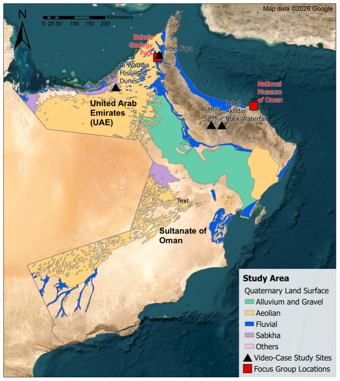
Figure 1Map of southeast Arabia showing Quaternary land surface characteristics, locations of case study sites in the videos, and locations where focus group meetings were conducted. Geological data derived from Pollastro et al. (1999).
Socioeconomically, both the UAE and Oman are predominantly Muslim countries that have undergone major economic development over the past two decades, with GDP growth exceeding 300 % driven largely by the expansion of the oil industry (Pirlea, 2023a, b). This growth has been accompanied by increasing proportions of migrant residents (United Nations Population Division, 2024) and rising tertiary education levels (World Bank, 2023). However, opportunities for geosciences education remain limited in both countries, particularly at school level (Ministry of Education, 2023; Ambusaidi and Al-Balushi, 2015; Al Ghfeli, 2016).
Quaternary geoscience research conducted in this region has significantly advanced our understanding of environmental variability during the Quaternary, and its impact on human demographics. Throughout the Quaternary, the landscape of southeast Arabia experienced alternating wetter and drier conditions (Parker et al., 2004; Parton et al., 2015a). By integrating archaeological and palaeoclimatic data, researchers such as Parker (2009) and Parton et al. (2015b) have highlighted the close correspondence between early human settlement and environmental variability in this region. This connection underscores the importance of Quaternary palaeoenvironmental sites not only as climatic archives but also as geocultural sites with relevance for regional archaeology and culture. These geocultural connections have been acknowledged by various Quaternary scientists (Farrant et al., 2015; Nicholson et al., 2020; Preston et al., 2015; Rosenberg et al., 2012; Zerboni et al., 2020; Atkinson et al., 2013) who cite archaeological relevance as a primary motivation for conducting their palaeoenvironmental research.
Despite various reports of their loss, only a limited number of studies have considered these Quaternary sites as heritage sites requiring and/or deserving conservation, despite various reports of their loss. A recent inventory of Quaternary palaeoenvironmental sites in this region identified the destruction of 31 out of 234 sites (13 %) along with endangerment of an additional 34 sites (15 %) (Sayama et al., 2022). This destruction was primarily due to urban development and quarrying. On the scale of individual sites, Lokier (2013) and Kirkham and Evans (2019) have emphasised the endangerment of the Abu Dhabi Sabkha, UAE, illustrating how recent developments in petroleum and civil engineering activities have damaged over 60 % of this landscape with unique heritage values. The loss of Quaternary sites has also been documented in palaeoenvironmental studies, such as Atkinson et al. (2011), where sites were destroyed by industrial development (Preston et al., 2015).
As outlined above, further investigation is required to advance science communication in Quaternary science and Quaternary geoheritage. This study aims to evaluate the effectiveness of incorporating geocultural context in communicating the value of Quaternary geoheritage sites in southeast Arabia, a region where degradation of such sites has been documented. To address this, we compare audience responses to two videos: one presenting Quaternary geoheritage within a geocultural framework, and the other adopting a purely geoscientific perspective. Responses are analysed across a sample of predominantly university-educated, pro-environment adults in their 20s and 30s residing in Oman and the United Arab Emirates
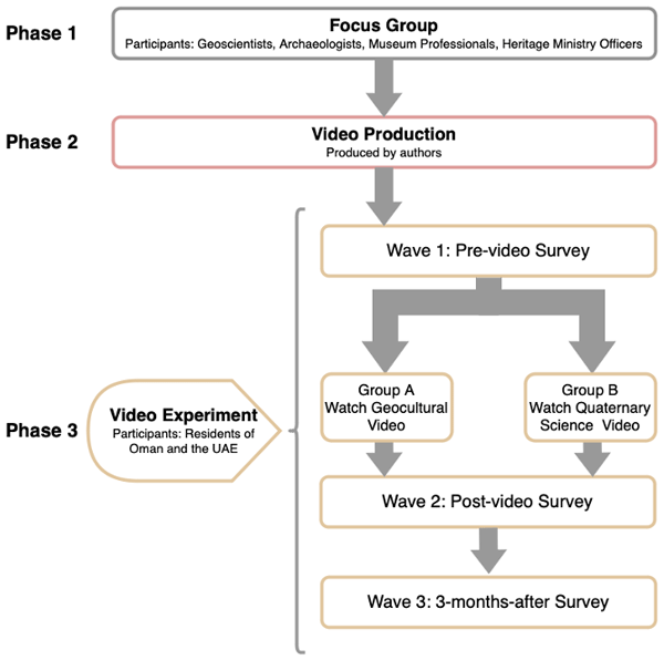
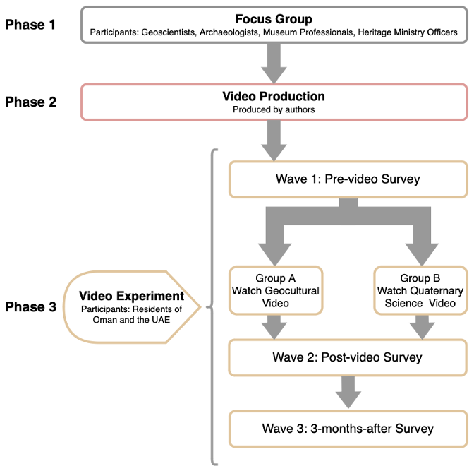
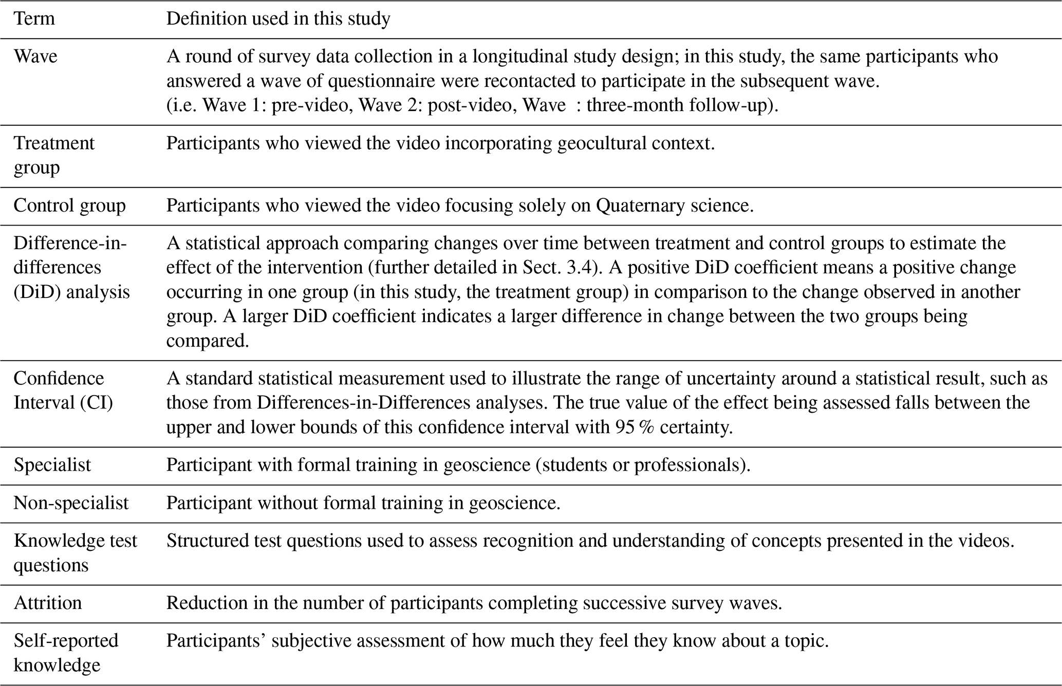
This study undertook a three-phase approach conducted between November 2022 and January 2024, as illustrated in Fig. 2. Phase 1, a preparatory phase, involved focus group meetings to identify suitable contents for the videos, while Phase 2 (Sect. 3.2) covered the production of the two videos, and Phase 3 (Sect. 3.3 and 3.4) consisted of the online experiment and data analysis, including three survey waves with random assignment to treatment and control groups after Wave 1. This article will focus primarily on analysing the results of Phase 3. Table 1 summarises the definition of terms as used in this study.
4.1 Phase 1: focus group to identify video content
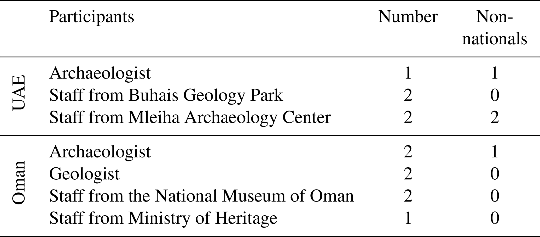
As a preparatory phase to determine the most appropriate content of the videos, focus group meetings were conducted in November 2022 at Buhais Geology Park (UAE), and in December 2022 at the Oman National Museum. Participants are described in Table 2. The authors presented the study aim, design, target audience, and focus to the participants, followed by descriptions of the relationship between archaeology, culture, and palaeoenvironment.
Table 2Participant profile for the focus group meetings conducted in this study.
Through deductive and inductive content analysis (Bengtsson, 2016) via NVivo, five key themes were identified as below:
-
egin the video with visually engaging footage and familiar sites before introducing technical Quaternary elements;
-
Structure content progressively from general overview to more detailed explanation;
-
Incorporate archaeological, cultural, and religious narratives where appropriate;
-
Use an accessible, conversational tone supported by locally grounded perspectives;
-
Frame geoheritage in relation to everyday values, such as natural beauty, cultural relevance, and conservation needs.
Overall, the focus group meetings underscored the importance of cultural connection in communicating Quaternary geoheritage. Detailed results of Phase 1 can be found in Supplement 1.
4.2 Phase 2: video production
Based on the insights above, two videos were developed by the authors in collaboration with partners. The videos were designed to be of similar length, with the primary distinction being an emphasis on the geocultural context in one (referred to as the geocultural or treatment video), and the exclusion of the geocultural context in favour of a more detailed description of the Quaternary science in the other (Quaternary science or control video). Other elements were designed to be as similar as possible. The videos incorporated footage filmed by the authors, as well as videos and photographs provided by collaborators, along with Creative Commons licensed visuals and music. Each video featured voice narration in English, complemented by dialogues with experts conducted in Arabic, with corresponding translation provided as subtitles in Arabic or in English. The videos were created specifically for this research project and are not intended to function as comprehensive museum or geopark interpretation tools. Prior to distribution, both videos were piloted and reviewed by focus group participants to ensure scientific accuracy and appropriate representation of cultural and social content.
The videos are available online (Control Video: https://ora.ox.ac.uk/objects/uuid:e14384cb-68fa-45f1-914d-3204e05bb3ea, last access: 20 June 2026, Treatment Video: https://ora.ox.ac.uk/objects/uuid:ee8c3f2a-1888-4967-a104-b5799ba68d8d, last access: 20 June 2026), and their structure, duration, and differences are summarised in Table 3.
Table 3Contents and duration of the two videos produced for the study, with explanations of the main differences. Contents with a indicate sections with different narration/dialogue between the two videos and contents with b indicate sections indicate sections where cultural content is inserted.
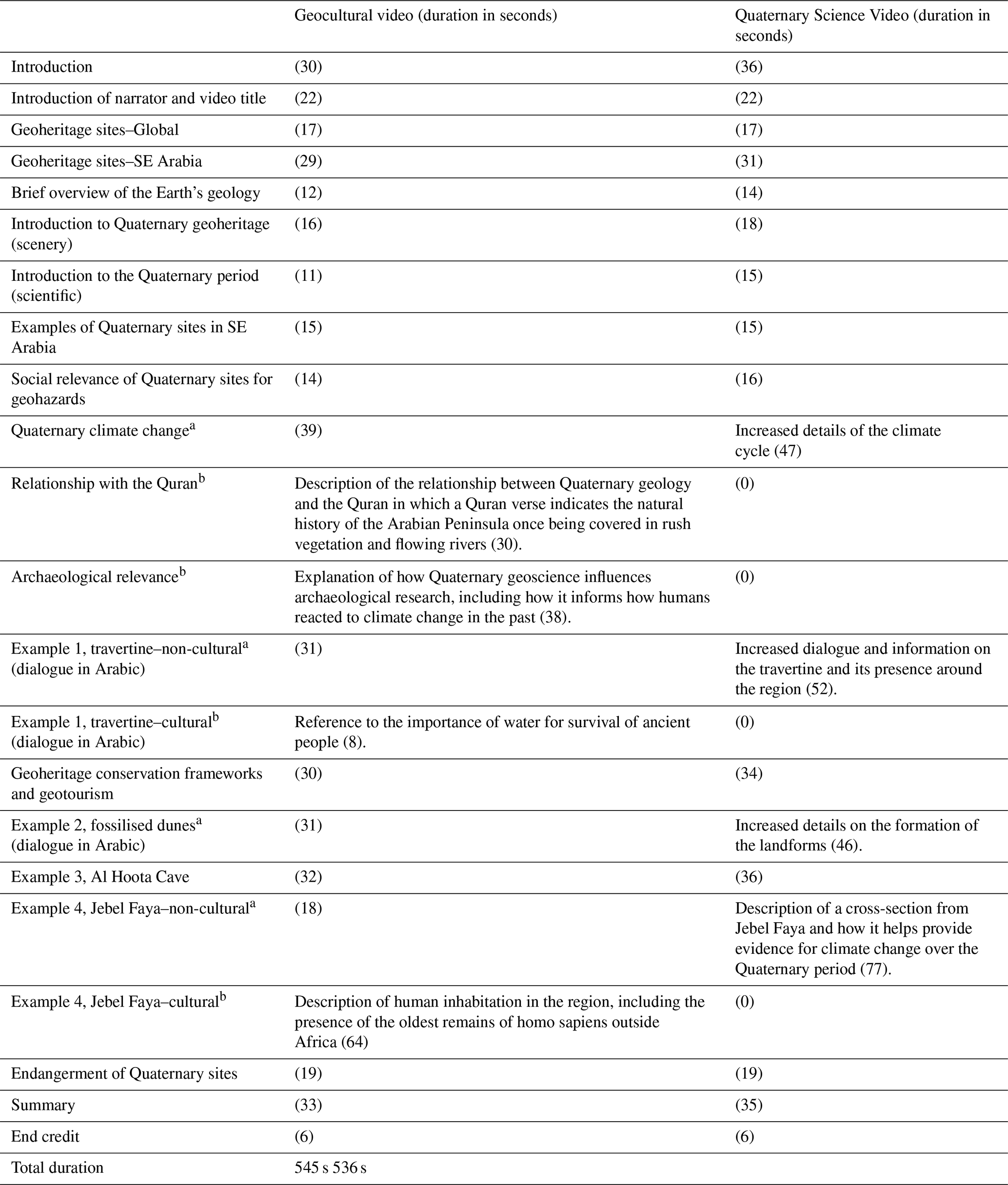
The total duration of the videos falls at the upper end of the 6–9 min duration range recommended in the literature for optimal audience engagement, at 9 min 5 s (545 s) for the geocultural video, and 8 min 56 s (536 s) for the Quaternary science video. The Quaternary science video incorporated additional scientific detail. The total duration of geocultural content was 140 s (approximately 26 %) in the geocultural video.
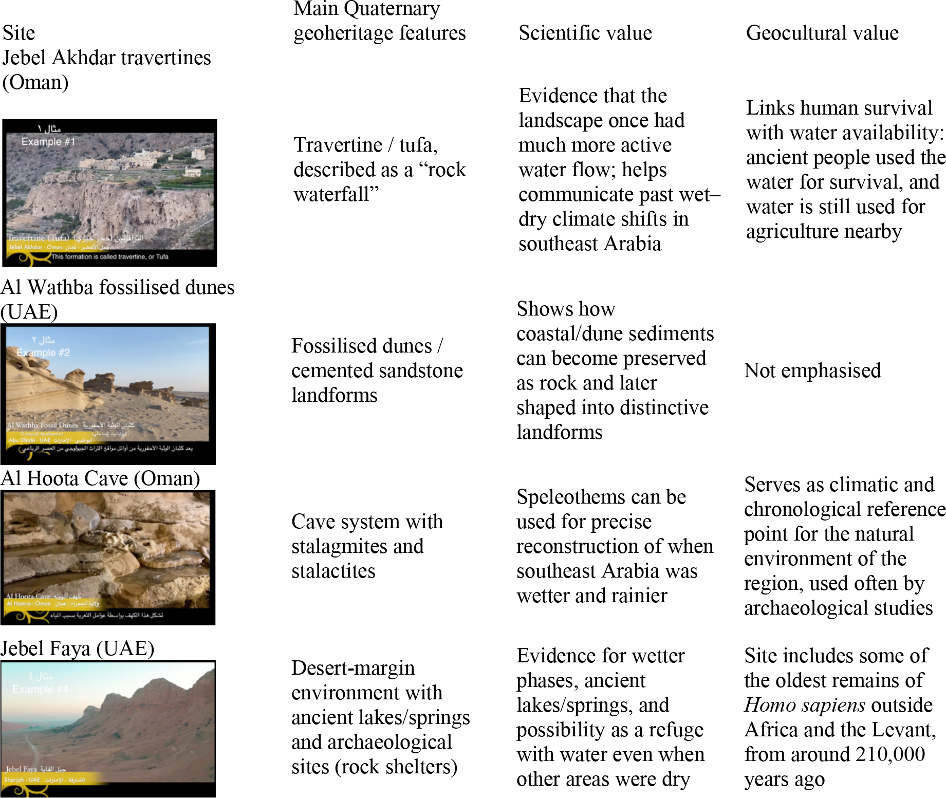
In these videos, three case study sites were selected to introduce four key Quaternary geoheritage sites in the region. These sites were selected for primarily for their scientific importance, but also for the representation of the variety of Quaternary sites in southeast Arabia. Table 4 summarizes the key features of the selected sites.
Table 4Description of Case Study sites and their key scientific and geocultural values.
4.3 Phase 3: video experiment
In phase 3, an online experiment was conducted using the videos produced in the second phase. Participants were recruited based on the inclusion criterion of being residents of the UAE or Oman. Recruitment efforts included calls at universities, as well as emails and posts through nature societies, museums, and social media platforms. The experiment consisted of three waves of surveys, including a questionnaire administered before, immediately after, and three months after watching the video. Upon completion of the pre-video questionnaire, participants were randomly divided into two groups: Group A (the treatment group), who watched the geocultural video, and Group B (the control group), who watched the Quaternary science video.
The study received 160 valid responses in Wave 1 (pre-video), 104 in Wave 2 (post-video), and 82 in Wave 3 (3 months after). Participant characteristics are summarised in Table 5. Although nationals of UAE and Oman were overrepresented relative to national demographics, comparative analyses revealed no statistically significant differences between national and non-national participants. While this study originally aimed to target the general public, the final sample was skewed towards a young, highly educated, and environmentally engaged demographic. This profile aligns with audiences commonly identified as potential geotourism participants in previous studies (Dowling and Allan, 2018; Kim et al., 2008; Štrba, 2019).
Table 5Breakdown of video study participants. All questions in the survey were optional, leading to some missing responses.
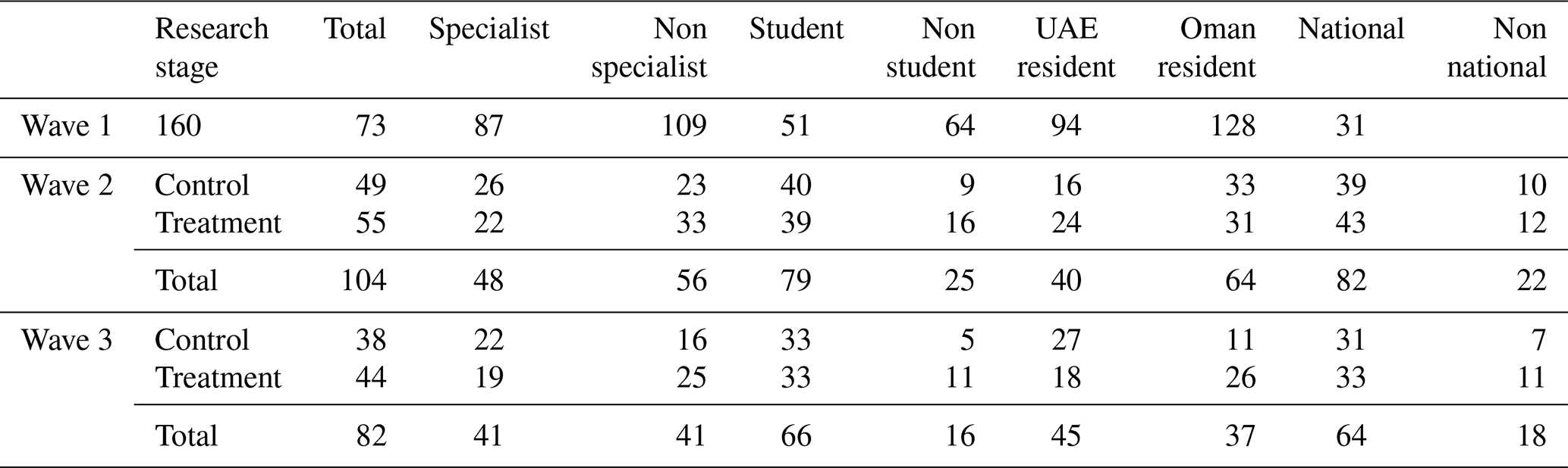
Drop-out rates were within or better than the expected range of 30 %–40 % for longitudinal studies (Grønmo, 2019), with a particularly low drop-out rate of 21 % between Waves 2 and 3. Given the total population of southeast Arabia at 14.1 million, according to Yamane's formula for sample size (Yamane, 1967), 104 participants who completed until Wave 2 represent the population of this region at a margin of error at ±9.8 %, while 82 participants who completed all three waves have a ±10.9 % margin. While smaller than the sample required for a ±5 % margin, this size was considered adequate for exploratory analysis, especially given the strong caveat that the study focused on a specific population of university students and adults with pro-nature views.
The majority of participants were university students (n=78), including 47 studying geosciences and 31 studying other disciplines. Of the 23 employed participants, only one worked in geology-related field. Participants who are geoscience students or professionals were classified as domain specialists (n=48) and the rest were categorised as non-specialists (n=56). Before watching the video, specialists were significantly more likely to report awareness of geoheritage sites (t test p<0.001) or Quaternary geoheritage sites (t test p=0.051 in χ2 test and p value = 0.035 in Fisher's exact test). Many specialists knew some geoheritage sites (95 %), but only half of them (50 %) could recognise or identify Quaternary geoheritage sites.
Participants of this study, regardless of their demographics, expressed strong pro-conservation attitudes prior to viewing the videos, with high rating of the importance of protecting natural heritage (mean = 9.2 out of 10, SD = 1.4). Support was similarly strong for geoheritage sites (mean = 9.0, SD = 1.7) and Quaternary geoheritage sites (mean = 8.6, SD = 2.0), although increasing specificity was associated with greater variability in responses.
All parts of the experiment were conducted using online questionnaires, with options to answer in Arabic or English. The questionnaire was first prepared in English and then translated into Arabic by one of the authors (Husam Al Rawahi), a native Arabic speaker and a geoscientist. Differences between the two language versions were reviewed and considered negligible in analysing the answers.
The questionnaires assessed participants' knowledge and interest in geoheritage sites, Quaternary geoheritage sites, archaeological sites, and the relationship between Quaternary geoheritage sites and archaeological sites. The Quaternary geoheritage section included two sets of knowledge test questions: one in which participants were asked to select photos of Quaternary geoheritage sites from a set of photos (see Fig. 3), and another in which they were asked to choose correct statements on relationships between Quaternary geology and archaeology observable in southeast Arabia (see Supplement 2 for full question wording). Both knowledge test questions were presented as multiple-choice questions with multiple correct and incorrect answers, to which participants were asked to select all correct answers. The score for these questions was calculated as the number of correct answers selected, minus the number of incorrect answers selected. After the Wave 2 questionnaire, participants received a list of additional resources where they could learn more about geoheritage sites and sites that were featured in the video. In Wave 3, additional questions were included to assess participants' impressions of the video and its impact.
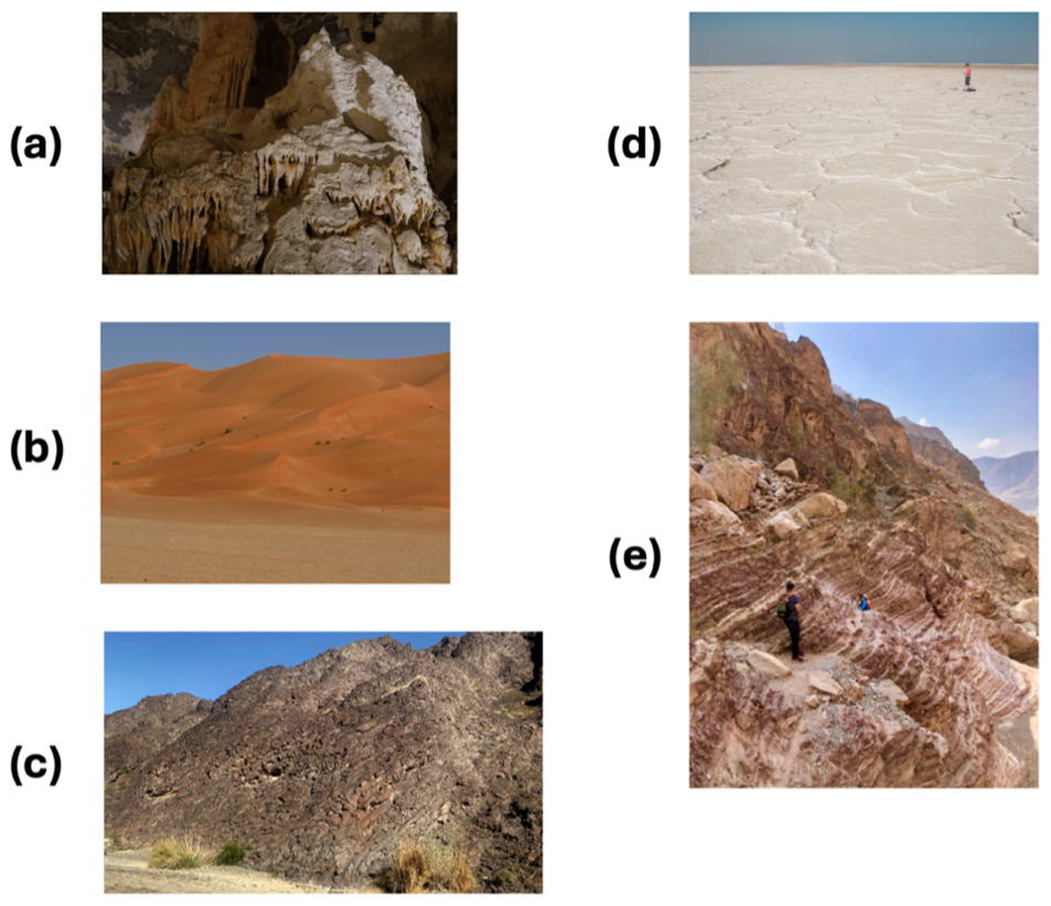
Figure 3Photos used in the knowledge test to identify Quaternary geoheritage sites. The correct answers are (a) cave features, (b) sand dunes and (d) sabkha.
Each questionnaire was designed to take between 5–10 min to complete. Most questions utilised a five-point Likert-like scale, in which higher values reflect higher levels of agreement, interest, or perceived importance, with exceptions including Yes/No questions, text-entry questions (mostly in Wave 3 regarding impressions and impact of videos), multiple-answer questions (including knowledge test questions), and questions on the importance of protecting certain types of sites, which were presented as a 10-point slider-scale. Text-entry questions were included to assess participants' recollection of Quaternary geoheritage sites.
4.4 Data analysis
The data collected from the questionnaires underwent quantitative and qualitative analysis, based on the nature of the questions. Although some discussion continues on the treatment of aggregated Likert-type data as an ordinal scale rather than discrete categories (Bishop and Herron, 2015), this study employed parametric methods to analyse this data in line with other studies such as De Winter and Dodou (2010).
A qualitative assessment was conducted on text entry question responses involving deductive and inductive content analysis using NVivo to categorise themes related to the research questions and emerging themes from the responses. The predetermined themes used for the deductive content analysis included those related to the key points mentioned in the focus groups, and options indicated in the questionnaire as multiple-choice questions.
Statistical analyses followed methods commonly used in Randomly Controlled Trial (RCT) experiments, where both treatment and control groups are present. Since both groups watched a video on geoheritage which would impact the outcome of the post-treatment (Wave 2) and follow-up (Wave 3) surveys, the study opted to use difference-in-differences (DiD) analysis with fixed effects for the treatment group and the survey wave. DiD analysis is a specific type of fixed effect analysis that is commonly used to evaluate treatment effects in natural experiments (see Abadie, 2005 for a detailed discussion). In this study, DiD enables an analysis of changes in participants' responses over time in the treatment group vis à vis the changes in the control group, thereby isolating the effect of including geocultural information in the video.
For Waves 2 and 3, all responses were initially compared to responses in Wave 1 using a t-test to account for statistically significant differences. Subsequently, DiD was conducted to assess the effects of the treatment. DiD analysis was conducted at two levels. First, it was conducted for all 82 participants who completed Wave 3. Then the participants were subdivided into specialist and non-specialist respondents to examine whether the treatment effect varied based on the respondent's level of prior subject knowledge.
When applied to samples of the size used in this study, estimates of treatment effects are accompanied by substantial statistical uncertainty. With 82 complete cases, the study is underpowered to reliably detect small effects, particularly under inference procedures that account for within-respondent dependence over time. We therefore emphasize effect-size estimates and uncertainty intervals by reporting 95 % confidence intervals (CIs) for our DiD analyses. Confidence intervals allow interpretation of the range of plausible directions and magnitudes for the true effect sizes, which is more informative for these data than significance-level reporting alone. For example, in cases where confidence intervals are narrow and centred near zero, we can rule out the presence of large treatment effects even when results are not statistically significant in the conventional sense. Across outcomes, many estimates remain imprecise, and we interpret findings in light of this uncertainty as reflected in the reported confidence intervals.
5.1 Impressions of the video after 3 months
Survey responses indicated positive and sustained impressions of both videos. Approximately half the participants in each group reported watching the video more than twice. Self-reported memory of content was higher in the treatment group (25 %) than in the control group (16 %).
Most participants (80 %) considered the video length appropriate, although 17 % felt it was slightly too long. This perception was more common in the control group (24 %) than in the treatment group (13 %). Regarding impact, 91 % of respondents reported increased interest in Quaternary geoheritage, with a slightly higher proportion in the treatment group, though differences were not statistically significant.
Of the 82 Wave 3 respondents, 46 provided open-ended text feedback (20 from treatment group and 26 from control group). These comments frequently cited positive aspects including learning outcomes (13), clarity of presentation (8), and beautiful scenery (8). Participants described the videos as accessible, clear, and engaging, and several highlighted the dialogue with local geologists as particularly effective. In contrast, only a small number of comments explicitly referenced Quaternary geoheritage sites (6), as opposed to general geoheritage sites (19). Suggestions for improvement were provided by 20 respondents, most commonly recommending a shorter duration, predominantly from control group participants (7 out of 8 instances). Conversely, several treatment group participants suggested including additional content to further expand their knowledge. Other recommendations focused on points to improve the production quality, such as including short animations (2), improving the narration (2), and improving the overall quality (3) as well as the delivery of the content, such as reducing complexity (3), and making the content more interesting (5).
5.2 Statistical analysis
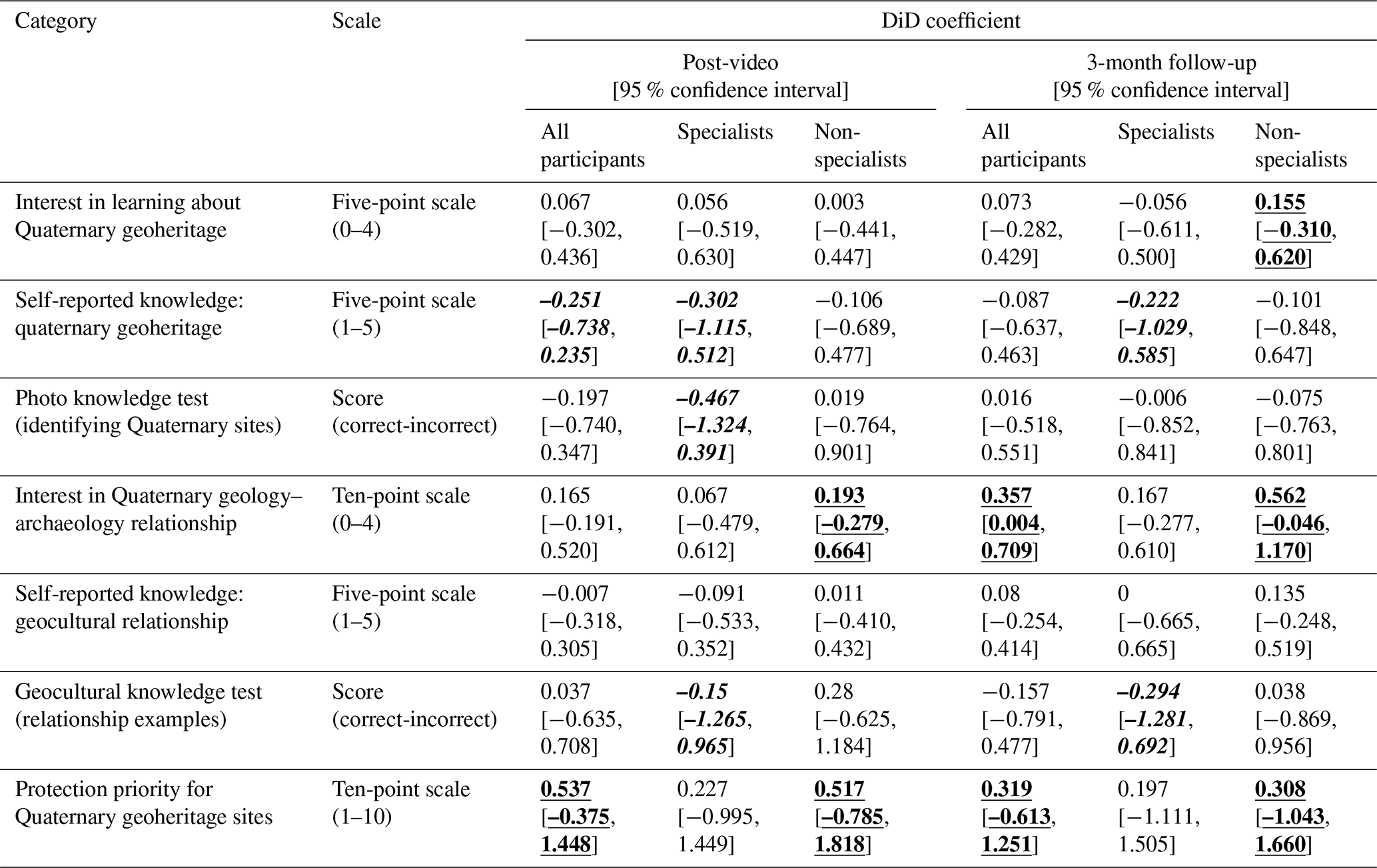
Statistical analysis of the questionnaire answers focused on the questions pertinent to Quaternary geoheritage sites and the geocultural context. The results of the seven target questions are shown in Fig. 4 and Table 6 and analysed further in the following sections. The detailed statistical figures for the DiD analysis can be found in Supplement 3.
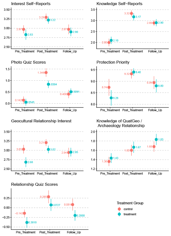
Figure 4Changes in questionnaire scores between three waves of questionnaires, including before treatment, post treatment, and follow up (3 months after the treatment), disaggregated by treatment group. The y axis indicates the score from either the knowledge test or the Likert-like scale.
Table 6Summary of DiD results. Underlined results indicate prominent outcomes where the treatment group showed positive change relative to the control group and italicised results indicate prominent outcomes where the control video performed better than the treatment video. The brackets indicate the upper and lower boundary values of the 95 % confidence interval.
5.3 Interest and knowledge on quaternary geoheritage sites
Interest in Quaternary geoheritage increased significantly immediately after viewing (t test p=0.0011), but this uplift was not evident at the three-month follow-up when comparing pre-video and follow-up distributions (p=0.55). Perceived knowledge, by contrast, increased strongly in the post-treatment survey (p<0.001) and remained significantly higher than baseline at follow-up (p<0.001), despite some degree of regression towards the mean.
Comparative analysis between the control and treatment group shows that for interest, DiD coefficients were small with confidence intervals around zero, effectively ruling out large effects. The only exception was a possible small positive effect among non-specialists at the follow-up survey, albeit with substantial uncertainty. For perceived knowledge, however, DiD analysis suggested a negative effect associated with assignment to the treatment group after Wave 2 for both specialists and non-specialists, although this effect dissipates by Wave 3. When comparing specialists and non-specialists in terms of perceived knowledge in Wave 2, specialists reported a greater increase than non-specialists.
The analysis of the knowledge test question on Quaternary geoheritage identification revealed a highly significant improvement in the scores immediately after video viewing (p<0.001). While a substantial degree of mean reversion was observed by the time of the follow-up survey, scores remained significantly higher than the pre-video scores (p=0.013). The DiD analysis provided a clearer picture. Immediately after viewing the videos, the treatment group showed smaller improvements than the control group. This initial better performance by the control group was driven entirely by specialist respondents. However, by the follow-up survey, the two groups performed almost the same, with the treatment group scoring slightly higher, despite the lower score in Wave 1.
5.4 Interest in, and knowledge on, the relationship between quaternary geology and archaeology
Interest in the relationship between Quaternary geology and archaeology showed a small but statistically significant increase immediately after viewing (p=0.028) at the level of all participants, but was statistically indistinguishable from baseline three months after watching the video. On the other hand, self-reported knowledge increased significantly immediately after viewing (p<0.001) and remained significantly higher than baseline at follow-up (p<0.001), indicating that participants' perceived understanding of the geocultural relationship continued to develop over time.
DiD analysis suggests that the treatment–control contrast was clearer for interest than for perceived knowledge. For interest, the treatment group, especially the non-specialists, showed a notably greater increase than the control group both immediately after viewing the video and three months after, with the follow-up effect particularly strong (CI lower-end value above 0), indicating a conventionally statistically significant finding, despite the small sample size.
Overall scores on the knowledge test for the relationship between Quaternary geology and archaeology question were extremely low across all survey waves, with mean values hovering around zero. Nevertheless, a statistically significant improvement was observed immediately after viewing the videos (p=0.0014). Scores in the follow-up survey were higher than baseline but not significantly so at the 95 % confidence level (p=0.109). The DiD analysis suggests that, overall, there was little to no difference between the treatment and control group.
5.5 Attitude towards the protection of guaternary geoheritage
A statistically significant increase in the view towards the protection of Quaternary sites was observed immediately after viewing the videos (p<0.001). Although scores exhibited a high degree of regression towards the mean by the follow-up survey, they remained slightly higher than pre-video levels. However, this difference was not statistically significant (p=0.142). It is notable that baseline scores were already high (mean ∼8.5, with the highest possible rating being 10), and very few respondents rated these sites as a low priority for protection.
DiD analysis suggests that the positive gains in this question were consistently stronger for the treatment group, with greater increases in protection priority than those in the control group overall. This effect was evident both immediately after and three-months after viewing the video. The positive effect was particularly strong for non-specialist respondents with the treatment group in particular. Specialists entered the study with higher baseline scores (a mean value of 9.13 versus 8.23 for non-specialists), which could have constrained the magnitude of observable change due to ceiling effects.
Taken together, the results indicate that the inclusion of geocultural context changed how participants responded to the video introducing the region's Quaternary geoheritage. The geocultural video did not produce stronger immediate knowledge outcomes than the Quaternary science-focused video, but it appears to have had advantages in sustaining engagement with the geocultural relationship and strengthening attitudes towards conservation. This distinction is central to interpreting the effectiveness of the geocultural approach: its main value lies less in delivering immediate factual knowledge, and more in making Quaternary geoheritage feel relevant, memorable, and worth protecting.
Comparative analysis of the two videos highlights a trade-off between short-term knowledge acquisition and longer-term memory retention and changes in opinions/attitudes. The control video, with its more singular and technical focus, likely functioned more effectively as an immediate educational resource, producing stronger post-video knowledge outcomes. The treatment video introduced a broader range of themes, potentially leading viewers to feel less confident about their specific knowledge of Quaternary geoheritage, whereas the more narrowly focused control video provided detailed scientific explanations that may have enhanced participants' perceptions of subject-specific expertise. However, after three months, this comparative advantage was largely lost, and both groups reported broadly similar levels of knowledge gain. These findings suggest that embedding scientific information within a geocultural narrative may not provide a clear advantage for short-term learning, but it also does not appear to hinder or dilute the learning experience in the medium term.
The results above are, in some ways, similar to those of Mani et al. (2016), who found that teaching volcanic hazards in St. Vincent (an island in the Caribbean region) through video games was slightly less effective as an educational tool than a traditional pedagogical presentation, but more effective for engagement in the learning process. In both studies, the treatment condition (the geocultural context in this study and the video-game setting in Mani et al., 2016) added content or framing to the core geoscientific material, which may have diluted the focus of the scientific content. A more direct delivery of the core content therefore appears to lead to better short-term knowledge outcomes. However, the findings from southeast Arabia demonstrate an additional dimension to this research area by showing that, three months after the intervention, the difference between the two groups dissipated, with some indication of a slight reversal.
In fact, the clearest advantage of the geocultural context appears to lie in maintaining interest and engagement over time, particularly among non-specialists. The treatment group sustained elevated interest in the relationship between Quaternary geology and archaeology, and to a lesser extent in learning about Quaternary geoheritage, although interest within the control group showed larger declines for both cases in Wave 3. This result supports the argument that geocultural framing works well to make Quaternary geoheritage more engaging and digestible for audiences without specialist training. This pattern aligns with established findings in geoscience education and communication literature, which suggest that individuals without prior training often find geological concepts, particularly those related to deep time, challenging to engage with (Trend, 1998, 2001), resulting in high barriers to initial learning (Rogers et al., 2024). By connecting Quaternary landforms to archaeology, religious narratives, local landscapes, and cultural memory, the treatment video provided more familiar points of entry into a topic that can otherwise feel abstract or technical.
On the other hand, specialists responded differently to the geocultural framing. For participants with prior geoscience training, the cultural connections may have been interesting, but they did not provide the same additional entry point as they did for non-specialists. Specialists may already have had sufficient background knowledge to understand the Quaternary significance of the sites and may therefore have benefited more from the more detailed scientific explanations included in the control video. This could explain why the control video produced stronger immediate knowledge outcomes among specialists, while the treatment video showed clearer advantages in engagement rather than factual learning. This suggests that geocultural context is most effective when it bridges the gap between scientific content and audience familiarity, rather than when communicating with audiences who already possess relevant technical knowledge.
However, the increased engagement associated with geocultural framing did not translate into gains in factual knowledge of the geocultural relationship. Although participants reported increased perceived knowledge after viewing the videos, performance on the objective knowledge test remained limited. This may reflect the inherent complexity of the topic, the difficulty of the assessment, or constraints associated with using a single question to capture learning outcomes.
The qualitative findings reinforce the efficacy of geocultural context as an engagement mechanism, as opposed to a tool for knowledge gain. Feedback indicated stronger engagement and greater tolerance for video length in the treatment group, with only 1 participant finding it too long. On the other hand, all participants suggesting the inclusion of more content was from the treatment group, who may have wanted more scientific content to deepen their knowledge on Quaternary sites.
The strongest practical implication of the study could be the effectiveness of the geocultural context in communicating the importance of protecting Quaternary geoheritage. The treatment video was more effective in strengthening and sustaining positive opinions about the importance of protecting Quaternary geoheritage sites. This result is consistent with the qualitative finding that geoheritage protection was the most frequently cited takeaway among treatment-group participants. Although the statistical results remain tempered by uncertainty, the overall pattern suggests that geocultural framing can foster a stronger and more durable sense of the importance of conserving Quaternary geoheritage, especially among people with less prior knowledge of such sites.
Overall, the effectiveness of geocultural context should be understood in relation to the communication outcome being prioritised. If the primary aim is immediate factual learning, a more focused geoscientific framing may be more effective. If the aim is to sustain interest, broaden accessibility, and strengthen conservation-oriented attitudes, the results suggest that geocultural framing offers clear advantages. From an outreach perspective, this supports the use of geocultural context as a complementary strategy for introducing Quaternary geoheritage to wider audiences, while also indicating that additional or more targeted educational strategies may be needed when the goal is deeper factual understanding.
Several limitations in this study should be acknowledged. First, the sample size was relatively small, particularly for the difference-in-differences analyses, which could only use 82 participants who completed all three survey waves. This limited statistical power and resulted in confidence intervals that were often wide, meaning that some of the results should be interpreted as indicative rather than conclusive. Second, the profile of the participants was skewed towards highly educated, younger participants with pre-existing interests in nature conservation and geoscience. Many respondents were university students or specialists, which likely contributed to high baseline levels of awareness and support for geoheritage protection, potentially amplifying some of the observed effects. Consequently, the findings cannot be directly generalised to the wider population of southeast Arabia or to other sociocultural contexts.
Future research involving more diverse demographic groups, lower baseline interest levels, and different regional settings is necessary to test the broader applicability of these results. In doing so, studies could involve videos of different length, which could help identify the best balance between depth and brevity in science communication efforts on Quaternary geoheritage and its cultural connections. Further work should also explore how geocultural framing can be combined with complementary educational strategies to support deeper factual learning alongside engagement. Future studies could also examine which elements of the geocultural narrative (e.g., identity-based framing, archaeology, religious narratives) drive interest and positive changes toward opinions on protection.
To enable longitudinal follow-up across the three survey waves, participants were asked as optional questions to provide their name, email address, WhatsApp contact, and institutional affiliation. These personal data were stored separately from the survey responses and were used only to contact participants about subsequent questionnaires. For analysis, each participant was assigned an anonymised code, and no personally identifiable information was included in the analytical dataset. The procedures obtained ethical approval by the Central University Research Ethics Committee (CUREC) at the University of Oxford to have followed the research protocols set out by the committee with the approval references: SOGE C1A 22 252 and SOGE C1A 23 15.
This study set out to evaluate the effectiveness the geocultural context in communicating the significance of Quaternary geoheritage sites in southeast Arabia. Using a three-phase research design, comprising focus groups to inform video content, video production, and a longitudinal online experiment, the study compared the impacts of two videos: one highlighting the geocultural context and the other focusing solely on Quaternary science. The analysis assessed changes in participants' knowledge, interest, and perceptions related to Quaternary geoheritage sites and their relationship with archaeology and human culture.
The experiment revealed that both videos were effective in increasing participants' awareness of Quaternary geoheritage and strengthening attitudes towards its protection. However, differences were observed in how audiences responded over time. The geocultural video outperformed the science-focused video in sustaining longer-term interest and fostering a stronger sense of the need for conservation, particularly among non-specialist participants. The control video functioned more effectively as an immediate educational tool, producing higher short-term knowledge gains, but the geocultural video demonstrated superior longer-term outcomes in terms of engagement and attitudinal change. These outcomes were supported both qualitatively and quantitatively. Methodologically, these findings highlight the importance of incorporating follow-up measurements in geoscience communication studies, as short-term learning outcomes alone may obscure more durable effects.
The results suggest two potential advantages of integrating geocultural context into communication strategies for Quaternary geoheritage. First, geocultural framing enhances engagement and accessibility, especially for non-specialists who may otherwise find Quaternary science abstract or difficult to approach. Second, although less effective as a teaching resource, the geocultural approach appears to strengthen pro-conservation attitudes towards Quaternary sites, suggesting its particular value in awareness raising and public engagement contexts rather than formal education alone.
In conclusion, despite the limitations of the small number and lack of diversity in participant profiles, this study helps advance the understanding of how integrating geocultural connections can enhance science communication efforts aimed at promoting awareness and conservation of Quaternary geoheritage. By leveraging the cultural relevance of these sites in communication strategies, Quaternary scientists and geoheritage practitioners can potentially enhance audience engagement, support sustained interest and inspire longer-term changes in the attitude towards the protection of Quaternary geoheritage sites. Although further research is required to corroborate the findings, this study offers valuable insights for refining communication strategies for complex scientific concepts and fostering public engagement with Quaternary science initiatives.
The underlying code used in this research can be accessed at: https://github.com/robfahey/QuaternaryGeoheritage_Materials (Fahey and Sayama, 2026).
The underlying data used in this research (with the personally identifiable information redacted) can be accessed at: https://github.com/robfahey/QuaternaryGeoheritage_Materials (Fahey and Sayama, 2026).
The supplement related to this article is available online at https://doi.org/10.5194/gc-9-291-2026-supplement.
Conceptualisation, KS, HV; Data curation, KS, HAR, RAF; Formal analysis, KS, RAF; Funding acquisition, KS; Investigation, KS, HAR, RAF; Methodology, KS, RAF, HV, AGP; Project administration, KS, HAR; Software, RAF, KS; Supervision, HV, AGP; Validation, KS, RAF; Visualisation, KS, RAF; Writing – original draft, KS; Writing – review and editing, KS, RAF, HV, AGP. All authors have read and agreed to the published version of the manuscript.
The contact author has declared that none of the authors has any competing interests.
This study was approved by the Central University Research Ethics Committee (CUREC) at the University of Oxford to have followed the research protocols set out by the committee with the approval references: SOGE C1A 22 252 and SOGE C1A 23 15.
Publisher's note: Copernicus Publications remains neutral with regard to jurisdictional claims made in the text, published maps, institutional affiliations, or any other geographical representation in this paper. The authors bear the ultimate responsibility for providing appropriate place names. Views expressed in the text are those of the authors and do not necessarily reflect the views of the publisher.
We would first like to thank Mr Khalid Mohammed for his contribution to the video study and Dr Joshua Ettinger for his support in developing the methodology of the overall study. Also, we thank collaborators who provided visuals for the videos. We would also like to extend our gratitude towards all the participants of the focus group for their valuable input. Finally, we thank the study participants for their valuable input.
This research has been supported by the British Society for Geomorphology (grant no. BSG-2022-08) and the Royal Geographical Society (grant no. PRA 29.22).
This paper was edited by Tiziana Lanza and reviewed by three anonymous referees.
Abadie, A.: Semiparametric Difference-in-Differences Estimators, Rev. Econ. Stud., 72, 1–19, https://doi.org/10.1111/0034-6527.00321, 2005.
Al Ghfeli, M.: United Arab Emirates, https://timssandpirls.bc.edu/timss2015/encyclopedia/countries/united-arab-emirates/ (last access: 20 June 2026), 2016.
Ambusaidi, A. and Al-Balushi, S.: Science Education in the Sultanate of Oman, in: Science Education in the Arab Gulf States: Visions, Sociocultural Contexts and Challenges, edited by: Mansour, N. and Al-Shamrani, S., SensePublishers, Rotterdam, 189–203, https://doi.org/10.1007/978-94-6300-049-9_10, 2015.
Atkinson, O. A., Thomas, D. S., Goudie, A. S., and Bailey, R. M.: Late Quaternary chronology of major dune ridge development in the northeast Rub'al-Khali, United Arab Emirates, Quatern. Res., 76, 93–105, 2011.
Atkinson, O. A. C., Thomas, D. S. G., Parker, A. G., and Goudie, A. S.: Late Quaternary humidity and aridity dynamics in the northeast Rub' al-Khali, United Arab Emirates: Implications for early human dispersal and occupation of eastern Arabia, Quatern. Int., 300, 292–301, https://doi.org/10.1016/j.quaint.2012.12.014, 2013.
Bengtsson, M.: How to plan and perform a qualitative study using content analysis, Nurs. Plus Open, 2, 8–14, https://doi.org/10.1016/j.npls.2016.01.001, 2016.
Bishop, P. A. and Herron, R. L.: Use and Misuse of the Likert Item Responses and Other Ordinal Measures, Int. J. Exerc. Sci., 8, 297–302, 2015.
Blechschmidt, I., Matter, A., Preusser, F., and Rieke-Zapp, D.: Monsoon triggered formation of Quaternary alluvial megafans in the interior of Oman, Geomorphology, 110, 128–139, https://doi.org/10.1016/j.geomorph.2009.04.002, 2009.
Boukhchim, N., Fraj, T. B., and Reynard, E.: Lateral and “Vertico-Lateral” Cave Dwellings in Haddej and Guermessa: Characteristic Geocultural Heritage of Southeast Tunisia, Geoheritage, 10, 575–590, https://doi.org/10.1007/s12371-017-0251-2, 2018.
Bowring, S. A.: Perceptions of Time Matter: The Importance of Geoscience Outreach, in: Geoscience Research and Outreach: Schools and Public Engagement, edited by: Tong, V. C. H., Springer Netherlands, Dordrecht, 11–15, https://doi.org/10.1007/978-94-007-6943-4_2, 2014.
Boylan, P. J.: Geological site designation under the 1972 UNESCO World Heritage Convention, Geol. Soc. Lond. Spec. Publ., 300, 279–304, https://doi.org/10.1144/sp300.22, 2008.
Brilha, J.: Geoheritage and Geoparks, in: Geoheritage: Assessment, Protection, and Management, edited by: Reynard, E. and Brilha, J., Elsevier, Amsterdam, 323–335, https://doi.org/10.1016/B978-0-12-809531-7.00018-6, 2018.
Bruno, B. C. and Wallace, A.: Interpretive Panels for Geoheritage Sites: Guidelines for Design and Evaluation, Geoheritage, 11, 1315–1323, https://doi.org/10.1007/s12371-019-00375-0, 2019.
Cayla, N.: An Overview of New Technologies Applied to the Management of Geoheritage, Geoheritage, 6, 91–102, https://doi.org/10.1007/s12371-014-0113-0, 2014.
Chakraborty, A. and Jones, T. E.: Mount Fuji: The Volcano, the Heritage, and the Mountain, in: Natural Heritage of Japan: Geological, Geomorphological, and Ecological Aspects, edited by: Chakraborty, A., Mokudai, K., Cooper, M., Watanabe, M., and Chakraborty, S., Springer International Publishing, Cham, 167–175, https://doi.org/10.1007/978-3-319-61896-8_16, 2018.
Churchward, C., Palmer, J., Nassauer, J., and Swanwick, C.: Evaluation of Methodologies for Visual Impact Assessments, Transportation Research Board, National Academy of Sciences, Washington, D.C., ISBN 978-0-309-25886-9, 2013.
Chylińska, D.: The Role of the Picturesque in Geotourism and Iconic Geotourist Landscapes, Geoheritage, 11, 531–543, https://doi.org/10.1007/s12371-018-0308-x, 2019.
Connor, S. and Maculuve, R.: The Importance of Listening to Mud, Kronos, 51, 1–8, 2025.
Coratza, P. and Hobléa, F.: The Specificities of Geomorphological Heritage, in: Assessment, Protection, and Management edited by: Reynard, E. and Brilha, J., Elsevier, 87–106, https://doi.org/10.1016/B978-0-12-809531-7.00005-8, 2018.
Coratza, P., Gauci, R., Schembri, J., Soldati, M., and Tonelli, C.: Bridging Natural and Cultural Values of Sites with Outstanding Scenery: Evidence from Gozo, Maltese Islands, Geoheritage, 8, 91–103, https://doi.org/10.1007/s12371-015-0167-7, 2016.
Dahlstrom, M. F. and Scheufele, D. A.: (Escaping) the paradox of scientific storytelling, PLOS Biol., 16, e2006720, https://doi.org/10.1371/journal.pbio.2006720, 2018.
De Winter, J. C. and Dodou, D.: Five-point Likert items: t test versus Mann-Whitney-Wilcoxon, Pract. Assess. Res. Eval., 15, 1–12, 2010.
Dolphin, G., Dutchak, A., Karchewski, B., and Cooper, J.: Virtual field experiences in introductory geology: Addressing a capacity problem, but finding a pedagogical one, J. Geosci. Educ., 67, 114–130, https://doi.org/10.1080/10899995.2018.1547034, 2019.
Dowling, R. and Allan, M.: Who are geotourists? A case study from Jordan, in: Handbook of geotourism, edited by: Dowling, R. and Newsome, D., Edward Elgar Publishing, 76–86, https://doi.org/10.4337/9781785368868.00014, 2018.
Dudley, M. Z., Squires, G. K., Petroske, T. M., Dawson, S., and Brewer, J.: The Use of Narrative in Science and Health Communication: A Scoping Review, Patient Educ. Counsel., 112, 107752, https://doi.org/10.1016/j.pec.2023.107752, 2023.
Dunn, M. E., Mills, M., and Veríssimo, D.: Evaluating the impact of the documentary series Blue Planet II on viewers' plastic consumption behaviors, Conserv. Sci. Pract., 2, e280, https://doi.org/10.1111/csp2.280, 2020.
Elias, S. A.: Societal Relevance of Quaternary Research, Elsevier, https://doi.org/10.1016/B0-44-452747-8/00002-8, 2007.
Erhartič, B.: Geomorphosite assessment, Acta Geogr. Sloven., 50, 295–319, https://doi.org/10.3986/AGS50206, 2010.
Ettinger, J., Walton, P., Painter, J., and DiBlasi, T.: Climate of hope or doom and gloom? Testing the climate change hope vs. fear communications debate through online videos, Climatic Change, 164, 19, https://doi.org/10.1007/s10584-021-02975-8, 2021.
Fahey, R. A. and Sayama, K.: Data and Code for the paper Including cultural context improves communication outcomes for quaternary geoheritage: evidence from southeast Arabia, GitHub [code and data set], https://github.com/robfahey/QuaternaryGeoheritage_Materials (last access: 5 July 2026), 2026.
Fairchild, I. and McMillan, E.: Speleothems as indicators of wet and dry periods, Int. J. Speleol., 36, https://doi.org/10.5038/1827-806X.36.2.2, 2007.
Farrant, A. R., Duller, G. A. T., Parker, A. G., Roberts, H. M., Parton, A., Knox, R. W. O., and Bide, T.: Developing a framework of Quaternary dune accumulation in the northern Rub' al-Khali, Arabia, Quatern. Int., 382, 132–144, https://doi.org/10.1016/j.quaint.2015.02.022, 2015.
Fepuleai, A., Weber, E., Németh, K., Muliaina, T., and Iese, V.: Eruption Styles of Samoan Volcanoes Represented in Tattooing, Language and Cultural Activities of the Indigenous People, Geoheritage, 9, 395–411, https://doi.org/10.1007/s12371-016-0204-1, 2017.
Fleitmann, D., Burns, S., Mudelsee, M., U., N., J., K., Mangini, A., and Matter, A.: Holocene Forcing of the Indian Monsoon Recorded in a Stalagmite from Southern Oman, Science, 300, 1737–1739, https://doi.org/10.1126/science.1083130, 2003.
Fontanella Pisa, P.: Understanding memory transmission in disaster risk reduction practices: A case study from Japan, Int. J. Disast. Risk Reduct., 100, 104112, https://doi.org/10.1016/j.ijdrr.2023.104112, 2024.
Gordon, J. E., Crofts, R., and Díaz-Martínez, E.: Geoheritage Conservation and Environmental Policies: Retrospect and Prospect, in: Geoheritage: Assessment, Protection, and Management, edited by: Reynard, E. and Brilha, J., Elsevier, Amsterdam, 213–235, https://doi.org/10.1016/B978-0-12-809531-7.00012-5, 2018.
Goudie, A. S., Colls, A., Stokes, S., Parker, A., White, K., and Al-Farraj, A.: Latest Pleistocene and Holocene dune construction at the north-eastern edge of the Rub Al Khali, United Arab Emirates, Sedimentology, 47, 1011–1021, 2000.
Grønmo, S.: Social Research Methods: Qualitative, Quantitative and Mixed Methods Approaches, SAGE Publications, London, UK, ISBN 10:1529616816, 2019.
Guo, P. J., Kim, J., and Rubin, R.: How video production affects student engagement: An empirical study of MOOC videos, in: Proceedings of the first ACM conference on Learning@ scale conference, 41–50, https://doi.org/10.1145/2556325.2566239, 2014.
Hamacher, D. W. and Goldsmith, J.: Aboriginal Oral Traditions of Australian Impact Craters, J. Astron. Hist. Herit., 16, 295–311, https://doi.org/10.3724/SP.J.1440-2807.2013.03.06, 2013.
Hoblea, F., Delannoy, J.-J., Jaillet, S., Ployon, E., and Sadier, B.: Digital Tools for Managing and Promoting Karst Geosites in Southeast France, Geoheritage, 6, 113–127, https://doi.org/10.1007/s12371-014-0112-1, 2014.
Illingworth, S.: A spectrum of geoscience communication: from dissemination to participation, Geosci. Commun., 6, 131–139, https://doi.org/10.5194/gc-6-131-2023, 2023.
Illingworth, S., Stewart, I., Tennant, J., and von Elverfeldt, K.: Editorial: Geoscience Communication – Building bridges, not walls, Geosci. Commun., 1, 1–7, https://doi.org/10.5194/gc-1-1-2018, 2018.
Immenhauser, A., Dublyansky, Y. V., Verwer, K., Fleitman, D., and Pashenko, S. E.: Textural, Elemental, and Isotopic Characteristics of Pleistocene Phreatic Cave Deposits (Jabal Madar, Oman), J. Sediment. Res., 77, 68–88, https://doi.org/10.2110/jsr.2007.012, 2007.
Isoda, Y., Muranaka, A., Tanibata, G., Hanaoka, K., Ohmura, J., and Tsukamoto, A.: Strengths of Exaggerated Tsunami-Originated Placenames: Disaster Subculture in Sanriku Coast, Japan, ISPRS Int. J. Geo-Inf., 8, 429, https://doi.org/10.3390/ijgi8100429, 2019.
Kaim, A., Jaffe, E., Siman-Tov, M., Khairish, E., and Adini, B.: Impact of a Brief Educational Intervention on Knowledge, Perceived Knowledge, Perceived Safety, and Resilience of the Public During COVID-19 Crisis, Int. J. Environ. Res. Publ. Health, 17, 5971, https://doi.org/10.3390/ijerph17165971, 2020.
Kiernan, K.: Landforms as Sacred Places: Implications for Geodiversity and Geoheritage, Geoheritage, 7, 177–193, https://doi.org/10.1007/s12371-014-0128-6, 2015.
Kim, S. S., Kim, M., Park, J., and Guo, Y.: Cave Tourism: Tourists' Characteristics, Motivations to Visit, and the Segmentation of Their Behavior, Asia Pacif. J. Tourism Res., 13, 299–318, https://doi.org/10.1080/10941660802280448, 2008.
King, D. N. and Goff, J. R.: Benefitting from differences in knowledge, practice and belief: Māori oral traditions and natural hazards science, Nat. Hazards Earth Syst. Sci., 10, 1927–1940, https://doi.org/10.5194/nhess-10-1927-2010, 2010.
Kirkham, A. and Evans, G.: Aspects of the Abu Dhabi Sabkha, in: Sabkha Ecosystems: Volume VI: Asia/Pacific, edited by: Gul, B., Böer, B., Khan, M. A., Clüsener-Godt, M., and Hameed, A., Springer International Publishing, Cham, 15–40, https://doi.org/10.1007/978-3-030-04417-6_3, 2019.
Kortz, K. M., Grenga, A. M., and Smay, J. J.: Establishing and Applying Literature-Based Criteria for Effective Communication of Science to Novices Via Introductory Geology Textbooks, J. Geosci. Educ., 65, 48–59, https://doi.org/10.5408/16-205.1, 2017.
Kubalíková, L., Kirchner, K., Kuda, F., and Bajer, A.: Assessment of Urban Geotourism Resources: An Example of Two Geocultural Sites in Brno, Czech Republic, Geoheritage, 12, https://doi.org/10.1007/s12371-020-00434-x, 2020.
Lansigu, C., Bosse-Lansigu, V., and Le Hebel, F.: Tools and Methods Used to Represent Geological Processes and Geosites: Graphic and Animated Media as a Means to Popularize the Scientific Content and Value of Geoheritage, Geoheritage, 6, 159–168, https://doi.org/10.1007/s12371-014-0101-4, 2014.
Leighton, C. L., Bailey, R. M., and Thomas, D. S. G.: Interpreting and modelling late Quaternary dune accumulation in the southern Arabian Peninsula, Quaternary Sci. Rev., 102, 1–13, https://doi.org/10.1016/j.quascirev.2014.08.002, 2014.
León, B. and Bourk, M.: Communicating Science and Technology Through Online Video: Researching a New Media Phenomenon, Taylor & Francis, ISBN 9780367607166, 2018.
Lokier, S. W.: Coastal Sabkha Preservation in the Arabian Gulf, Geoheritage, 5, 11–22, https://doi.org/10.1007/s12371-012-0069-x, 2013.
Ludwin, R. S., Smits, G. J., Carver, D., James, K., Jonientz-Trisler, C., McMillan, A., Losey, R., Dennis, R., Rasmussen, J., and De Los Angeles, A.: Folklore and earthquakes: Native American oral traditions from Cascadia compared with written traditions from Japan, Geol. Soc. Lond. Spec. Publ., 273, 67–94, 2007.
Manasrah, A., Masoud, M., and Jaradat, Y.: Short Videos, or Long Videos? A Study on the Ideal Video Length in Online Learning, in: 2021 International Conference on Information Technology (ICIT), Amman, Jordan, 366–370, https://doi.org/10.1109/ICIT52682.2021.9491115, 2021.
Mani, L., Cole, P. D., and Stewart, I.: Using video games for volcanic hazard education and communication: an assessment of the method and preliminary results, Nat. Hazards Earth Syst. Sci., 16, 1673–1689, https://doi.org/10.5194/nhess-16-1673-2016, 2016.
Matias, A., Carrasco, A. R., Ramos, A. A., and Borges, R.: Engaging children in geosciences through storytelling and creative dance, Geosci. Commun., 3, 167–177, https://doi.org/10.5194/gc-3-167-2020, 2020.
Melelli, L., Bizzarri, R., Baldanza, A., and Gregori, L.: The Etruscan “Volumni Hypogeum” Archeo-Geosite: New Sedimentological and Geomorphological Insights on the Tombal Complex, Geoheritage, 8, 301–314, https://doi.org/10.1007/s12371-015-0162-z, 2016.
Melendez, G., Fermeli, G., and Koutsouveli, A.: Analyzing geology textbooks for secondary school curricula in Greece and Spain: educational use of geological heritage, Bull. Geol. Soc. Greece, 40, 1819–1832, https://doi.org/10.12681/bgsg.17143, 2007.
Migoń, P. and Pijet-Migoń, E.: Interpreting Geoheritage at New Zealand's Geothermal Tourist Sites – Systematic Explanation Versus Storytelling, Geoheritage, 9, 83–95, https://doi.org/10.1007/s12371-016-0185-0, 2017.
Ministry of Education: Electives Model, https://www.moe.gov.ae/En/MediaCenter/Announcements/Electives/Pages/default.aspx (last access: 20 February 2024), 2023.
Mitchell, N.: Study on the Application of Criterion (vii): Considering superlative natural phenomena and exceptional natural beauty within the World Heritage Convention, IUCN, Gland, Switzerland, 113 pp. https://whc.unesco.org/uploads/events/documents/event-992-14.pdf (last access: 20 June 2026), 2013.
Moradi, A., Maghsoudi, M., Moghimi, E., Yamani, M., and Rezaei, N.: A Comprehensive Assessment of Geomorphodiversity and Geomorphological Heritage for Damavand Volcano Management, Iran, Geoheritage, 13, 39, https://doi.org/10.1007/s12371-021-00551-1, 2021.
Moreno, R. and Mayer, R. E.: Cognitive Principles of Multimedia Learning: The Role of Modality and Contiguity, J. Educ. Psychol., 91, 358–368, https://doi.org/10.1037/0022-0663.91.2.358, 1999.
Mucivuna, V. C., Motta Garcia, M. D. G., and Reynard, E.: Comparing quantitative methods on the evaluation of scientific value in geosites: analysis from the Itatiaia National Park, Brazil, Geomorphology, 396, 107988, https://doi.org/10.1016/j.geomorph.2021.107988, 2022.
Nicholson, S. L., Pike, A. W. G., Hosfield, R., Roberts, N., Sahy, D., Woodhead, J., Cheng, H., Edwards, R. L., Affolter, S., Leuenberger, M., Burns, S. J., Matter, A., and Fleitmann, D.: Pluvial periods in Southern Arabia over the last 1.1 million-years, Quaternary Sci. Rev., 229, 106112, https://doi.org/10.1016/j.quascirev.2019.106112, 2020.
Oguchi, T. and Oguchi, C. T.: Mt. Fuji: The Beauty of a Symmetric Stratovolcano, in: Geomorphological Landscapes of the World, edited by: Migoń, P., Springer Netherlands, 303–309, ISBN 978-90-481-3055-9, 2010.
Panizza, M. and Piacente, S.: Cultural geomorphology and geodiversity, Geomorphosites, Pfeil Verlag, Munich, 35–48, ISBN 978-3-89937-094-2, 2009.
Parker, A.: Pleistocene Climate Change in Arabia: Developing a Framework for Hominin Dispersal over the Last 350 ka, in: Evolution of Human Populations in Arabia: Paleoenvironments, Prehistory and Genetics, edited by: Petraglia, M. and Rose, J. I., Springer, Dordrecht, 39–49, https://doi.org/10.1007/978-90-481-2719-1_3, 2009.
Parker, A., Eckersley, L., Smith, M., Goudie, A., Stokes, S., Ward, S., White, K., and Hodson, M.: Holocene vegetation dynamics in the northeastern Rub'al-Khali desert, Arabian Peninsula: a phytolith, pollen and carbon isotope study, J. Quaternary Sci., 19, 665–676, 2004.
Parton, A., Farrant, A., Leng, M., Telfer, M., Groucutt, H., Petraglia, M., and Parker, A.: Alluvial fan records from southeast Arabia reveal multiple windows for human dispersal, Geology, 43, 295–298, https://doi.org/10.1130/G36401.1, 2015a.
Parton, A., White, T. S., Parker, A. G., Breeze, P. S., Jennings, R., Groucutt, H. S., and Petraglia, M. D.: Orbital-scale climate variability in Arabia as a potential motor for human dispersals, Quatern. Int., 382, 82–97, https://doi.org/10.1016/j.quaint.2015.01.005, 2015b.
Pasquaré Mariotto, F. and Venturini, C.: Strategies and Tools for Improving Earth Science Education and Popularization in Museums, Geoheritage, 9, 187–194, https://doi.org/10.1007/s12371-016-0194-z, 2017.
Pereira, P. and Pereira, D.: Methodological guidelines for geomorphosite assessment, Géomorphologie, 16, 215–222, https://doi.org/10.4000/geomorphologie.7942, 2010.
Pereira, P., Pereira, D., and Caetano Alves, M. I.: Geomorphosite assessment in Montesinho Natural Park (Portugal), Geogr. Helv., 62, 159–168, https://doi.org/10.5194/gh-62-159-2007, 2007.
Pica, A., Reynard, E., Grangier, L., Kaiser, C., Ghiraldi, L., Perotti, L., and Del Monte, M.: GeoGuides, Urban Geotourism Offer Powered by Mobile Application Technology, Geoheritage, 10, 311–326, https://doi.org/10.1007/s12371-017-0237-0, 2018.
Pirlea, A. F.: Country Profile – Oman, World Bank, https://databank.worldbank.org/views/reports/reportwidget.aspx?Report_Name=CountryProfile&Id=b450fd57&country=OMN (last access: 20 June 2026), 2023a.
Pirlea, A. F.: Country Profile – United Arab Emirates, World Bank, https://databank.worldbank.org/views/reports/reportwidget.aspx?Report_Name=CountryProfile&Id=b450fd57&country=UAE (last access: 20 June 2026), 2023b.
Planas-Batlle, X., Tort-Donada, J., and Corominas, J.: Reconocimiento de zonas afectadas por fenómenos geológicos peligrosos a través de la toponimia. El alto Pirineo catalán, andorrano y áreas circundantes como caso de estudio, Revista de la Sociedad Geológica de España, 36, 3–15, 2023.
Pollastro, R. M., Karshbaum, A. S., and Viger, R. J.: Maps showing geology, oil and gas fields and geologic provinces of the Arabian Peninsula, Report 97-470B, USGS, Reston, VA, https://doi.org/10.3133/ofr97470B, 1999.
Preston, G. W., Thomas, D. S. G., Goudie, A. S., Atkinson, O. A. C., Leng, M. J., Hodson, M. J., Walkington, H., Charpentier, V., Méry, S., Borgi, F., and Parker, A. G.: A multi-proxy analysis of the Holocene humid phase from the United Arab Emirates and its implications for southeast Arabia's Neolithic populations, Quatern. Int., 382, 277–292, https://doi.org/10.1016/j.quaint.2015.01.054, 2015.
Radies, D., Hasiotis, S., Preusser, F., Neubert, E., and Matter, A.: Paleoclimatic significance of Early Holocene faunal assemblages in wet interdune deposits of the Wahiba Sand Sea, Sultanate of Oman, J. Arid Environ., 62, 109–125, 2005.
Reis, J., Póvoas, L., Barriga, F. J. A. S., Lopes, C., Santos, V. F., Ribeiro, B., Cascalho, J., and Pinto, A.: Science Education in a Museum: Enhancing Earth Sciences Literacy as a Way to Enhance Public Awareness of Geological Heritage, Geoheritage, 6, 217–223, https://doi.org/10.1007/s12371-014-0105-0, 2014.
Ren, F., Simonson, L., and Pan, Z.: Interpretation of Geoheritage for Geotourism – a Comparison of Chinese geoparks and National Parks in the United States, Czech J. Tourism, 2, 105–125, https://doi.org/10.2478/cjot-2013-0006, 2013.
Reynard, E.: The assessment of geomorphosites, in: Geomorphosites, edited by: Reynard, E., Coratza, P., and Regolini-Bissig, G., Verlag Dr. Friedrich Pfeil, Munich, Germany, 63–71, ISBN 9783899370942, 2009.
Reynard, E. and Giusti, C.: The Landscape and the Cultural Value of Geoheritage, in: Geoheritage: Assessment, Protection, and Management, edited by: Reynard, E. and Brilha, J., Elsevier, Amsterdam, 147–166, https://doi.org/10.1016/B978-0-12-809531-7.00008-3, 2018.
Reynard, E., Coratza, P., and Regolini-Bissig, G.: Geomorphosites, Verlag Dr. Friedrich Pfeil, Munich, Germany, ISBN 9783899370942, 2009.
Rodrigues, J., Castro, C., Costa e Silva, E., and Pereira, D. I.: Geoscientists' views about science communication: predicting willingness to communicate geoscience, Geosci. Commun., 6, 15–25, https://doi.org/10.5194/gc-6-15-2023, 2023.
Rogers, S. L., Giles, S., Dowey, N., Greene, S. E., Bhatia, R., Van Landeghem, K., and King, C.: “you just look at rocks, and have beards” Perceptions of Geology From the United Kingdom: A Qualitative Analysis From an Online Survey, Earth Sci. Syst. Soc., 4, https://doi.org/10.3389/esss.2024.10078, 2024.
Rosenberg, T. M., Preusser, F., Blechschmidt, I., Fleitmann, D., Jagher, R., and Matter, A.: Late Pleistocene palaeolake in the interior of Oman: a potential key area for the dispersal of anatomically modern humans out-of-Africa?, J. Quaternary Sci., 27, 13–16, 2012.
Ruzi, S. A., Lee, N. M., and Smith, A. A.: Testing how different narrative perspectives achieve communication objectives and goals in online natural science videos, PLOS ONE, 16, e0257866, https://doi.org/10.1371/journal.pone.0257866, 2021.
Santos, D. S., Mansur, K. L., Seoane, J. C. S., Mucivuna, V. C., and Reynard, E.: Methodological Proposal for the Inventory and Assessment of Geomorphosites: An Integrated Approach focused on Territorial Management and Geoconservation, Environ. Manage., 66, 476–497, https://doi.org/10.1007/s00267-020-01324-2, 2020.
Sayama, K.: Promoting diversity in geoheritage evaluation: creating an evaluation method for the scientific value of Quaternary sites in arid environments, Philos. T. Roy. Soc. A, 382, 20230138, https://doi.org/10.1098/rsta.2023.0138, 2024.
Sayama, K., Parker, A. G., Parton, A., and Viles, H.: Developing a Geocultural Database of Quaternary Palaeoenvironmental Sites and Archaeological Sites in Southeast Arabia: Inventory, Endangerment Assessment, and a Roadmap for Conservation, Sustainability, 14, 14096, https://doi.org/10.3390/su142114096, 2022.
Sousa, A., García-Murillo, P., Sahin, S., Morales, J., and García-Barrón, L.: Wetland place names as indicators of manifestations of recent climate change in SW Spain (Doñana Natural Park), Climatic Change, 100, 525–557, https://doi.org/10.1007/s10584-009-9794-9, 2010.
Stewart, I. S. and Nield, T.: Earth stories: context and narrative in the communication of popular geoscience, Proc. Geolog. Assoc., 124, 699–712, https://doi.org/10.1016/j.pgeola.2012.08.008, 2013.
Štrba, L'.: Analysis of Criteria Affecting Geosite Visits by General Public: a Case of Slovak (Geo)Tourists, Geoheritage, 11, 291–300, https://doi.org/10.1007/s12371-018-0283-2, 2019.
Subedi, S., Hetényi, G., and Shackleton, R.: Impact of an educational program on earthquake awareness and preparedness in Nepal, Geosci. Commun., 3, 279–290, https://doi.org/10.5194/gc-3-279-2020, 2020.
Trend, R.: An investigation into understanding of geological time among 10- and 11-ear-old children, Int. J. Sci. Educ., 20, 973–988, https://doi.org/10.1080/0950069980200805, 1998.
Trend, R.: An Investigation into the Understanding of Geological Time among 17-year-old Students, with Implications for the Subject Matter Knowledge of Future Teachers, Int. Res. Geogr. Environ. Educ., 10, 298–321, https://doi.org/10.1080/10382040108667447, 2001.
United Nations Population Division: International migrant stock, World Bank [data set], https://doi.org/10.18356/b4899381-en, 2024.
Van Loon, A. F., Lester-Moseley, I., Rohse, M., Jones, P., and Day, R.: Creative practice as a tool to build resilience to natural hazards in the Global South, Geosci. Commun., 3, 453–474, https://doi.org/10.5194/gc-3-453-2020, 2020.
Warmold, D.: Deep Time: A public engagement literature review, https://docplayer.net/154047097-Deep-time-a-public-engagement-literature-review- dan-wormald-february-learning-and-audience-research-department.html (last access: 20 April 2024), 2017.
World Bank: Educational attainment, at least Bachelor's or equivalent, population 25+, total (%) (cumulative), https://data.worldbank.org/indicator/SE.TER.CUAT.BA.ZS (last access: 20 June 2026), 2023.
Yadav, A., Phillips, M. M., Lundeberg, M. A., Koehler, M. J., Hilden, K., and Dirkin, K. H.: If a picture is worth a thousand words is video worth a million? Differences in affective and cognitive processing of video and text cases, J. Comput. High. Educ., 23, 15–37, https://doi.org/10.1007/s12528-011-9042-y, 2011.
Yamane, T.: Statistics: An Introductory Analysis, 2, Harper & Row, New York, 1967.
Zawacki, E. E., Bohon, W., Johnson, S., and Charlevoix, D. J.: Exploring TikTok as a promising platform for geoscience communication, Geosci. Commun., 5, 363–380, https://doi.org/10.5194/gc-5-363-2022, 2022.
Zerboni, A., Perego, A., Mariani, G. S., Brandolini, F., Al Kindi, M., Regattieri, E., Zanchetta, G., Borgi, F., Charpentier, V., and Cremaschi, M.: Geomorphology of the Jebel Qara and coastal plain of Salalah (Dhofar, southern Sultanate of Oman), J. Maps, 16, 187–198, https://doi.org/10.1080/17445647.2019.1708488, 2020.
- Abstract
- Introduction
- Regional setting
- Aim of the study
- Methodology
- Results
- Discussion
- Limitations and future directions for research
- Ethical statement
- Conclusions
- Code availability
- Data availability
- Author contributions
- Competing interests
- Ethical statement
- Disclaimer
- Acknowledgements
- Financial support
- Review statement
- References
- Supplement
- Abstract
- Introduction
- Regional setting
- Aim of the study
- Methodology
- Results
- Discussion
- Limitations and future directions for research
- Ethical statement
- Conclusions
- Code availability
- Data availability
- Author contributions
- Competing interests
- Ethical statement
- Disclaimer
- Acknowledgements
- Financial support
- Review statement
- References
- Supplement