the Creative Commons Attribution 4.0 License.
the Creative Commons Attribution 4.0 License.
 | 23 Oct 2026
Perceptions and recommendations: exploring the ethics of using satellite data to understand, monitor, and publish research on international geohazards
Jessica A. Payne

Kate Donovan
Over the last 10 years, open-access Earth observation satellite data volumes have grown exponentially. Through use of this data, geohazard remote sensing scientists' abilities to impact policy and reduce societal vulnerability to geohazards has become increasingly tangible. However, much of this open-access data is acquired, stored, and disseminated by the Global North, whilst most disasters take place in the Global South. Furthermore, many societies imaged by satellites may be unaware that these satellites operate. There exists little ethical guidance for geohazard remote sensing researchers in navigating ethical risks in this context. We explore these ethical considerations with UK based geohazard remote sensing scientists through 13 interviews and three focus group discussions. We discuss with scientists their thoughts on ethical review systems for geohazard remote sensing; the importance of visiting study regions; how data should be handled which images people and societies; the desired impact these scientists want to achieve; and the ethical risks of open data. We find amongst remote sensing researchers in industry, government organisations, and academia a deep desire to contribute to the reduction of societal vulnerabilities to geohazards. In accordance with geoethical practice, all participants are driven to produce world-leading research outputs to contribute to disaster risk reduction. However, we find amongst the academic geohazard remote sensing community a misunderstanding around the purpose and need to consider research ethics, focusing mainly on personal privacy rather than ethical risks associated with their own research. This community additionally struggles to balance their desire of meaningfully reducing societal vulnerability to geohazards with the demands of academic expectations and national excellence frameworks. Consequently, despite best intentions, time, funding, and academic pressures sometimes drive researchers to seek and publish data and results without consultation with in-country communities, particularly post disaster. We recommend geohazard remote sensing researchers receive training to promote the need and ability to reduce ethical risks in their research through five main topics, including practices for decolonisation of geohazard research. We propose a light-touch ethical review system at project design stage would strengthen ethical risk identification and mitigation. Our findings and recommendations are in accordance with geoethical practice and build on the Sendai Framework for Disaster Risk Reduction.
- Article
(2236 KB) - Full-text XML
- BibTeX
- EndNote


There exists an ever increasing volume of systematically acquired, open-access, global Earth observation datasets acquired by satellites (Wright, 2024). Since the pioneering decision by NASA to make the entire Landsat archive open-access in 2008 (Woodcock et al., 2008), there has been increasing effort by international space agencies to make their data freely available for all users. In 2014, the European Space Agency (ESA) began releasing open-access data from its Copernicus programme (Potin et al., 2016), with Copernicus data downloads increasing 133 % 2016–2019 (Wright, 2024). This increasing volume of open-access data, coupled with advances in compute power and machine learning practices (Salcedo-Sanz et al., 2020; Smith and Majumdar, 2020; Ghorbanian et al., 2020) offers the prospect of, for example, near-real time geohazard monitoring in remote or inaccessible regions (Li et al., 2018; Thirugnanam et al., 2020), imaging and understanding sub-daily deformation processes (Hjartardóttir et al., 2023; Queiroz de Almeida et al., 2021), as well as understanding the interplay of surface deformation drivers at continental scale (Elliott et al., 2026). Such technical advances offer the possibility of providing more detailed, reliable information to decision makers and local civil protection who act to reduce the risk of society to geohazards.
In academic research, funders including the World Bank (World Bank, 2012) and UK Research and Innovation (UKRI; Fathallah, 2022) often stipulate research outputs must be published open-access alongside any research articles which they fund. Publishing geohazard research open-access provides unlimited access to research by geohazard stakeholders. This access, as some argue (e.g. Woo, 2017), enables geohazard public education, improves geohazard research knowledge and quality, and thus, potentially, enables Disaster Risk Reduction (DRR). In this study, we define open-access according to the United Nations Educational, Scientific and Cultural Organization (UNESCO) definition of open science in their Recommendation on Open Science (UNESCO, 2021), in which they suggest “open science encourages scientists to develop tools and methods for managing data so that as much data as possible can be shared as appropriate”.
UKRI states that only outputs which are based on commercially confidential data, third-party materials, or those that potentially identify human participants are exempt from their open-access policy. This open-access approach leaves little scope or guidance for potentially sensitive research which investigates, for example, illegal activity (e.g. Fakhri and Gkanatsios, 2021, focusing on monitoring illegal fishing) or research focusing on conflict regions (e.g. Kurekin et al., 2019, aiming to detect post-conflict damage in Mosul, Iraq).
In addition, these ever-expanding and advancing open-access data archives and geophysical analysis techniques are in tension with some DRR practices. Historically, disaster risk reduction research study design processes often focus on co-creating and co-producing geohazard research with local stakeholders (e.g. Tran and Kim, 2023; Barton et al., 2020; Scolobig and Pelling, 2016). Recent DRR work literature has emphasised the importance of forging partnerships with local communities to better enable risk reduction and resilience building (Stewart et al., 2023). Co-creation and co-production ensures that research aims benefit local actors, methodologies are sensitive to local conventions and may involve local knowledge, and research outputs are useful and used by local stakeholders.
There also exist inequities in the global satellite geohazard remote sensing community. For example, disasters associated with geohazards often occur in Global South communities, but representation of these communities in western academic literature is minimal (Khan, 2022). Additionally, satellite data knowledge transfer tends to flow from Global North to Global South, with hazard and disaster research potentially exerting “soft power” towards Global South communities (Andrabi, 2022). These power dynamics continue to exist despite efforts in the Global North to share more openly and equitably data relating to, for example, surface deformation (e.g. European Ground Motion Service; NASA-ISRO SAR (NISAR) capacity building and training tools; Solari et al., 2022; Meyer et al., 2024).
In addition to these power imbalances in the digital space, conducting geohazard science exterior to the study region of interest removes the need for the non-national researcher to engage with the local regulatory framework (Fisher et al., 2021). If a geohazard scientist were to engage in fieldwork in-country, they would need to adhere to local regulatory controls and permissions regarding, for example, study region access (often through permits, such as in Indonesia; Wahyono, 2015). Seeking such permissions can encourage or require the researcher to engage with local communities, and commit to sharing results with in-country partners and decision makers (Zuccaro et al., 2020; Fisher et al., 2021). Satellite remote sensing bypasses these regulatory frameworks and subsequent serendipitous or mandatory engagement with local communities, thus reducing the opportunities for knowledge exchange and adherence to the Sendai Framework for Disaster Risk Reduction (Sendai Framework; UNWCDRR, 2015). This Framework guides global DRR practice and principles with the overall aim of reducing loss of lives and assets through disasters, 2015–2030.
On a broader scale, recent interdisciplinary work has defined the concept of “critical remote sensing” (related to “critical GIS”; Elwood and Wilson, 2017) which encourages researchers to recognise the politics and positionalities involved in satellite imagery (Elwood, 2007; Bennett, 2020; Bennett et al., 2022, 2024). Through definitions, examples, and frameworks for implementation, critical remote sensing literature discusses how remote sensing has contributed to understanding the global environment but can come with risks of, for example, becoming detached from communities and insensitive to political frameworks and institutions which enable global remote sensing (Bennett et al., 2024). Critical remote sensing in total `seeks to encourage reflexivity' and catalyse discussion on the ethics of remote sensing by remote sensing practitioners through application of their framework (Bennett et al., 2024).
This paper presents the perceptions of UK-based geohazard researchers on the ethical risks and dilemmas that they may encounter when using satellite data to research non-UK geohazards. We define geohazards following Tomás and Li (2017): “events related to the geological state and processes that pose potential risks to people, properties and/or the environment, which can be classified within two main categories: natural hazards (such as earthquakes, landslides, volcanic eruptions, tsunamis, and floods) and human-induced hazards (such as land subsidence due to groundwater-extraction, water contamination, and atmosphere pollution)”. We define an ethical dilemma as a choice between two alternative outcomes, where the chosen solution to the dilemma is that which is deemed most acceptable given the specific economic, social, cultural, and environmental context and values in which an individual is acting (Peppoloni et al., 2019).
We conduct one-on-one interviews and focus group discussions (FGDs) with UK-based geohazard researchers who use or have used satellite data in their research. These researchers work in settings including academic institutes, commercial organisations (or “industry”), and governmental research organisations (GROs). We explore with participants themes including: the role of ethical review in geohazard remote sensing; the ethics of conducting research without visiting study regions; researcher responsibilities towards imaged societies; tensions between desired impact and academic pressures; and the ethical implications of open data. In our Discussion, we explore how our participants' perceptions align with existing ethical frameworks and principles relevant to the geohazard remote sensing discipline (Bobrowsky et al., 2017; Peppoloni and Capua, 2017; Mogk et al., 2017; UNWCDRR, 2015; Memarian and Doleck, 2023).
In line with other studies which explore ethical issues in various fields or research disciplines (e.g. Gupta, 2017; Argyropoulos et al., 2011; Mertz and Strech, 2014; Gelinas et al., 2017), we use our discussion to highlight ethical deficiencies in the geohzard remote sensing discipline. We correspondingly make recommendations for the UK-based geohazard research community to improve community recognition and mitigation of ethical risks in satellite geohazard research. These recommendations focus on bespoke ethics training for this research community, as well as refinement of research excellence frameworks such as the UK Research Excellence Framework (REF, e.g. Torrance, 2020) to explicitly value local as well as global research impact. Our findings and recommendations are in accordance with geoethical practice (e.g. Peppoloni et al., 2019), build on the Sendai Framework for DRR (UNWCDRR, 2015), and are in line with the emerging field of “critical remote sensing” (Bennett et al., 2022, 2024).
To explore ethical risks, perceptions and risk mitigation in the UK-geohazard remote sensing community, we conducted a qualitative study using two approaches: semi-structured interviews and Focus Group Discussions (FGDs). In both cases, we explored in the context of research ethics how remote sensing scientists based in the UK use, analyse, and translate data and research derived from satellite data.
We used a grounded theory approach to develop our research methodology, which is defined by Cutcliffe (2001) as: “a theory that is induced from the data rather than preceding them”. In this approach, we collected and analysed data simultaneously, with analysed data informing our choices in the next data collection stage, a method referred to as constant comparative analysis (Glaser and Strauss, 1967; Charmaz, 2015). As grounded theory is an emergent approach, we used data to develop an understanding of ethical considerations without applying preconceived theoretical frameworks. Unexpected theories are therefore more likely to emerge that challenge researchers' preconceptions and representation of research participants (Charmaz, 2015). In this vein, we adopted the constructivist revision of grounded theory (Bryant, 2002, 2003; Charmaz, 2000, 2006; Mills et al., 2006), in which researchers focus on engaging in reflexivity: scrutinising the research process and situation which may influence data collection, analysis, and interpretation. This self-reflective approach is particularly important given the involvement of the authors in the same UK remote sensing community as many of the interview and FGD participants, an involvement which may provide the authors with preconceptions around remote sensing ethics.
Indeed, we used grounded theory to inform our data collection strategies. We iteratively interviewed, analysed, and reflected on the developing themes emerging from interviews and later FGDs to influence participant sampling strategies, questions used in data collection, and analysis approaches.
2.1 Participant sampling
2.1.1 Interviews
We selected participants for one-on-one interviews using a targeted sampling approach in which participants were identified based on specific criteria. Targeted participants were at the time of interview: (1) employed in the UK; (2) had current or previous experience working with satellite remote sensing data in the context of geohazards. We aimed to recruit participants from across the UK remote sensing spectrum aiming, where possible, to diversify participant gender, career length, and career stage.
Participants optionally self-identified their age, nationality, gender, the current and previous sector(s) they had worked in, the current and previous role(s) they had held, and the number of years they had used satellite data in their job or career.
All seven initial interview participants were members of The Centre for Observing and Modelling Earthquakes and Volcanoes (COMET), a UK-scale community of world-leading scientists who study earthquakes, volcanoes, and other geohazards using remote sensing techniques. We conducted these initial interviews May–June 2023, using these interview results to build themes and questions for Focus Group Discussions (FGDs) held at the COMET Annual Meeting 2023 on 26 June 2023. After FGDs, we conducted a further four interviews in June–July 2023 with the same question structure as the initial seven interviews. These later interview participants were actively selected to diversify participant demographics, thus challenging and testing initial themes (negative case analysis; Charmaz, 2015). Finally, after initial coding and analysis of these first 11 interview transcripts, a further two interviews were conducted in February 2024 to further test emerging hypotheses relating to female participants and those employed in industry.
We chose to focus on scientists in the UK to purposefully limit the scope of the study. This choice allowed time for a more complete exploration of key study themes with remote sensing scientists and professionals who work within the same legislative framework, have similar access to satellite datasets, and most likely experience a similar world view. Additionally, focusing on only UK remote sensing scientists made it more likely that we would be able to recruit a mix of participants which was representative of the UK remote sensing community, given that two authors were already members of this group.
2.1.2 Focus group discussions
FGDs were conducted in person at the COMET Annual Meeting 2023 at the British Geological Survey Keyworth site. Meeting attendees were given the option to partake either in this study's FGDs or one of two other parallel “Breakout Group Discussion” sessions. These parallel sessions were allocated 50 min. Meeting attendees were notified of these breakout session options via email one week before the FGDs took place, but attendees had up until the start of the parallel breakout sessions to opt-in or out. Due to this self-selecting approach, there was a strong diversity to the FGD participants. Additionally, as we did not restrict the FGDs to staff only, as we did for the interviews, the diversity of career stage and age was greater than that for the interviews. This approach we hoped would widen the diversity of voices within each focus group, thus generating a greater diversity of opinion and increasing the likelihood of differing opinion between group members, enabling us to analyse how focus group members dealt with differing ethical considerations for satellite data science.
Overall, 22 COMET Annual Meeting 2023 attendees self-selected to take part in the FGDs. We split this group randomly into three smaller groups to enable discussion. Focus group one had seven participants, group two had eight, and group three had seven. All participants except one in group one submitted a Participant Information Form and Consent Form meaning we lack personal identifying information for this participant. Verbal consent, however, was gained from all participants. A breakdown of FGD participant information can be found in Fig. B1.
2.2 Data collection
Following grounded theory, we conducted data analysis during and alongside data collection to test developing theories. As the same author planned and conducted data collection, data transcription, and data analysis, the same author viewpoints, subjectivity, and preconceptions are applied at all stages. Thus, exploring and reflecting on researcher positionality and potentially incorporated preconceptions was more straightforward (Charmaz, 2015). Moreover, this author was more likely to pick-up on nuances revealed by participants during interviews and FGDs as the author was present throughout.
2.2.1 Interviews
We conducted 13 semi-structured one-on-one interviews ranging in length from 37 to 59 min with a mean length of 49 min. We divided the interviews into five main sections: (1) Participant background; (2) regions that the participant has conducted research in or on that they perceive as challenging politically or socially; (3) ethical implications of using satellite data for geohazard research; (4) land subsidence specific questions; (5) translation and communication of satellite remote sensing outputs. Each section was broken down further into sub-sections depending on participants' research experiences. Each sub-section contained a list of questions that were a mix of closed and open, with question choice depending sometimes on participants' previous answers. This questioning structure allowed consistency between interview approaches and provided structure and direction for participants. However, following the grounded theory approach, if topics arose which participants appeared to define as crucial and important, these would take precedent over the planned interview structure (Charmaz, 2015). Equally, if a participant was not responding well or openly to the planned line of questioning, the interviewer moved on to topics which the interviewer sensed would ease the participant into the interview environment, thus changing the planned interview structure.
Due to this paper focusing on the ethics of remote sensing, in our results and discussion we present responses to topics “Ethical implications of using satellite data for research” and “Translation and communication of satellite remote sensing outputs”.
Participants were given the option to conduct the interview online or in-person. Four participants opted to complete the interview online. We conducted eight of the rest of the interviews in person at the University of Leeds and another at the British Geological Survey Keyworth site. In-person interviews were recorded using Audacity Version 3.3.2 (Audacity Developer Team, 2023). Online interviews were recorded using either Zoom (Zoom, 2023) or Microsoft Teams' recording facilities.
2.2.2 Focus group discussions
We conducted three FGDs in parallel with discussions led and guided by moderators. We designed FGD topics and questions to test if interview-derived themes corroborated, extended, or challenged interview themes. Thus, FGDs were designed to validate emerging interview themes through triangulation. We focused on three main topics with focus groups.
FGD Topic 1 focused on remote sensing and ethical review. In interviews we asked: “Research involving human participants requires ethical review. Research that observes humans using satellite data of any spatial resolution does not. What do you think of this statement?”. We found that 25 % of initial interviewees were negative towards the introduction of an ethical review process; 45 % had a mixed view; whilst 30 % felt positively towards an ethical review. Given these mixed opinions, we were interested in how FGD members' views would develop through discussion.
Topic 2 explored study region access. We asked in interviews: “If a scientist cannot visit the study region, should they still research it [using satellite remote sensing data]?”. In interviews this was a contentious topic, with many participants offering passionate, defensive responses drawn from personal experience in their own projects in which they used solely remote sensing data. Others considered potential negative consequences of not visiting a study site. We wanted to explore in FGDs whether participants' held similarly strong positions, and how participants responded if challenged on these positions. We also hypothesised that participant age and career experience would impact participant responses and thus wanted to test this question on a further diversity of voices.
Topic 3 explored how participants define making an “impact” in their work. In initial interviews we asked: “How would you define making “impact” when researching geohazards using remote sensing?”. We aimed to explore participant motivations, hypothesising that they would focus on advancing scientific theory or reducing societal risk. Many participants in initial interviews said that the ultimate “impact” of their work was protecting people and saving lives. We wanted to see if this aim was consistent in FGDs, and if participants challenged each others' desired impacts.
2.3 Transcription, coding, and theme development
We transcribed interviews and FGDs verbatim – ommitting non-lexical fillers – to maintain accurate representation of our participants (Poland, 1995). We used coding to analyse these transcripts (e.g. Cope, 2009). Prior to transcript coding, we did not pre-determine any codes or themes. We only derived codes when reading transcripts during our analysis stage, thus deriving and codes, categories, and themes purely from the data (Fig. 1). We clustered codes established during interview transcript analysis into categories. This clustering was based on codes' conceptual meaning, and was guided by application of Jaccard's coefficient (Fig. 1; Niwattanakul et al., 2013). This coefficient clusters codes by similarity of transcript words assigned to each code. However, as Jaccard's coefficient measures word similarity rather than conceptual similarity, clusters were verified against transcript data to ensure code groups were also conceptually coherent. Using this approach, we derived five categories: perceptions of ethical frameworks and ethical risks; research relationships and power structures; researcher responsibilities towards imaged communities; research motivations, impact, and institutional pressures; and data access and equity.
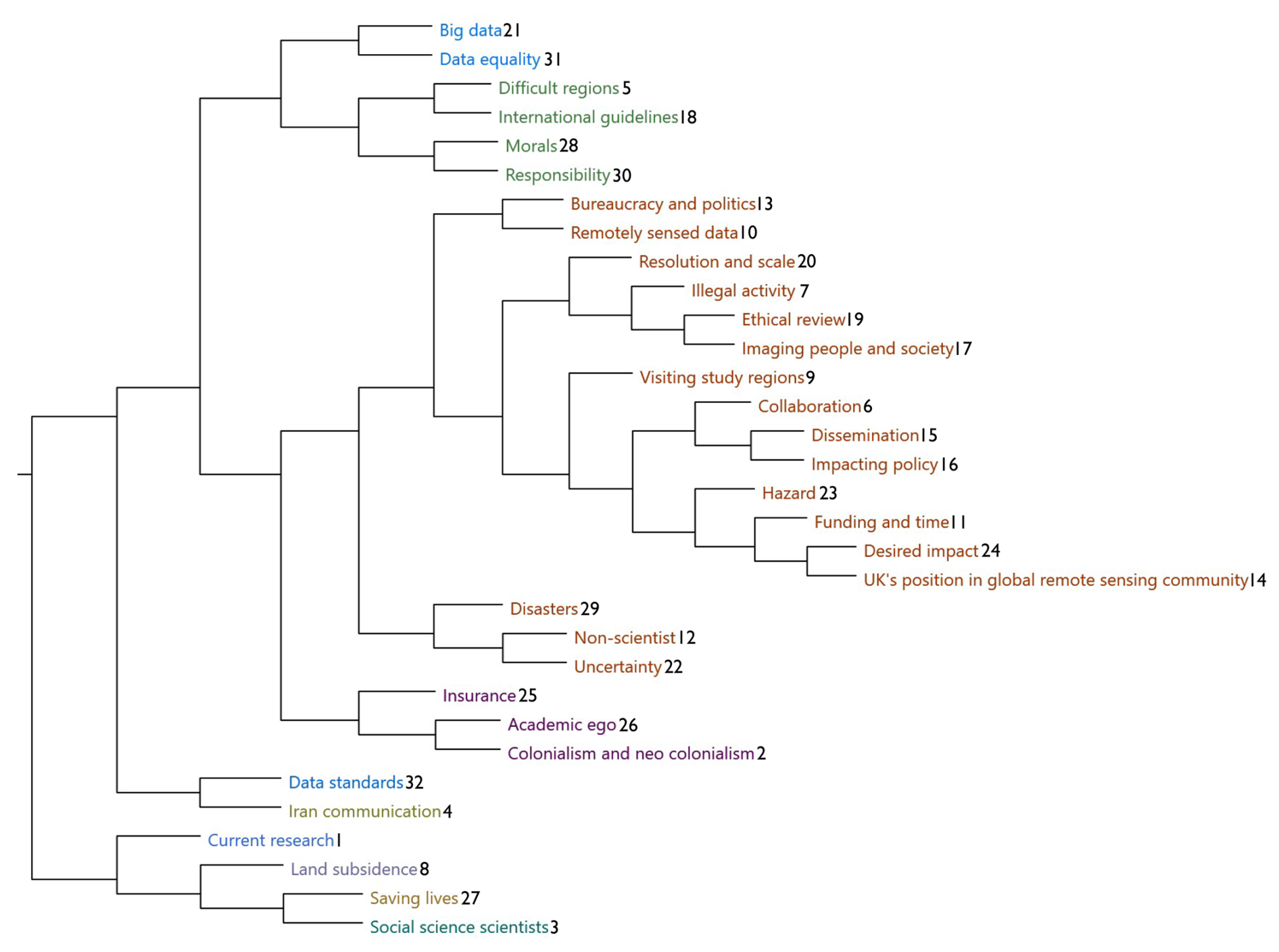
Figure 1Transcription code evolution. Cluster diagram of the main (not descendant) codes which arose during interview (not FGD) transcription analysis. Numbers at the end of each code show the order in which codes were introduced to analysis, with codes introduced based on themes arising in interviewee transcripts. Codes are clustered by the similarity of transcript words in each code, with similarity measured by Jaccard's coefficient. Jaccard's coefficient estimates code similarity using intersection over union of words in codes.
We then derived higher-level themes from code categories which described, explained, and contextualised the ethical reflections and perceptions of UK-based geohazard remote sensing scientists on their field. For example, the category “research motivations, impact, and institutional pressures” includes codes related to desired impact, saving lives, funding and time, and academic ego. These codes reveal both what participants want to achieve in their research, but also the structural tension between these desires and the structures under which they operate. We identified five themes which structure the results of this paper: the contested role of ethical review in remote sensing; the ethics of conducting research without visiting study regions; researcher responsibilities towards imaged societies; tensions between desired impact and academic incentives; the ethical implications of open data.
Following the approach of reflexive grounded theory, we continually sought to validate and challenge emerging themes. To validate themes, we triangulated data collected through interviews with data collected through FGDs. Where FGD responses differed from interview responses, this difference was treated as analytically important and reported in the results. For example, FGD participants expressed stronger views on the need to visit study regions compared to interview participants. To challenge emerging themes, we employed negative case analysis (Charmaz, 2015). For example, our initial interview participant sample was broadly unfavourable of considering ethical risks in remote sensing study designs. We deliberately then recruited a greater diversity of participants who differed in demographic to test if they were more favourable of considering such risks. This intensive, iterative approach (Sayer, 1992) built a conceptual theory from in-depth data until theoretical sufficiency (when sufficient data has been collected to develop a useful, plausible, and coherent theory; Charmaz, 2015; Dey, 1999), rather than seeking a statistically representative sample. Through these reflexive strategies, we determined that our sample size enabled theoretical sufficiency.
2.4 Methodological limitations
We acknowledge that exploration of these themes with this community comes with inherent positionality risks, particularly as the authors are themselves members of the geohazard remote sensing community. This community involvement shaped multiple stages of the research process: our choice of research questions reflects concerns relevant to UK-based researchers; our interpretation of participant responses may have been influenced by shared assumptions and remote sensing norms that we did not consider interrogating; and participants may have responded differently with less critical distance knowing they were speaking to peers. Whilst our study design passed ethical review and our participant sample is broadly representative of the UK-based geohazard remote sensing community, ethical review and sample representativeness do not eliminate interpretive bias. We have attempted to mitigate these risks through consistent reflection throughout the study. However, we recognise that our analysis remains partial and situated (Haraway, 1988), and that researchers positioned differently might draw different conclusions from the same data.
Aside from author positionality, participant positionality further limits the generalisability of our findings, as all study participants were geohazard remote sensing researchers based in the UK. Since geographic and institutional position shapes both knowledge production and ethical perception (Haraway, 1988; Bennett et al., 2024), findings from this community may not reflect the views of remote sensing practitioners elsewhere. Our findings and subsequent recommendations may therefore only be generalisable and appropriate, respectively, to geohazard remote sensing communities in the UK. Furthermore, our selected participants were not best placed to identify remote sensing ethical risks in the local, imaged society, including those related to local collaboration. Therefore, any results in this paper discussing local, in-country ethics will not fully represent ethical issues experienced by locals impacted by geohazards in regions studied remotely by UK researchers. Future work comparing these UK-based perceptions on, for example, local collaboration to those from local communities would be valuable.
There are additionally limitations to our participant sampling strategy, size, and positionality. Despite our sample size being sufficient to reach theoretical sufficiency (Dey, 1999; Charmaz, 2015), there is a risk that we do not reach theoretical saturation (Thomson, 2011). This failure would mean some relevant perspectives of the UK remote sensing community are not captured, thus further limiting the generalisation of our results to the wider UK remote sensing science community. However, by using our interview and FGD results to inform interview participant selection, as well as conducting both interviews and FGDs, we are confident that our methodology will yield well developed, internally validated results.
Demographic limitations of our sample presents a further constraint. Most of our interview participants were male (76 %), with COMET-associated males making up 69 % of participants. This gender ratio is nonetheless representative of the proportion of UK geophysics academics and researchers who are not women (79 % and 68 %, respectively; McWhinnie, 2023), as well as the proportion of COMET early career researchers who are male (∼70 %; COMET, 2024).
As interviews and FGDs were conducted in a small time window of 10 months, the results represent a snapshot of opinions and considerations of the ethics of geohazard remote sensing for UK researchers. We divide our results by themes that emerged from these interviews and FGDs.
3.1 Theme 1: the role of ethical review in geohazard remote sensing
We asked interview and FGD participants: “Research involving human participants requires ethical review. Research that observes humans using satellite data of any spatial resolution does not. What do you think of these statements?”. We did not explain the process of an ethical review, leaving it up to the participant to reflect on what ethical review means to them. Around a quarter of interviewees responded favourably around implementing ethical review for satellite remote sensing of geohazards, one participant was against, and two-thirds had a mixed view. In focus groups, views were mixed but in general all three groups agreed that ethical review should be considered under some circumstances.
3.1.1 Geohazard science for risk reduction
There was strong focus by interview participants on the ethically positive nature of their geohazard research, which they cited as contributing to geohazard risk reduction. One interview participant vehemently against ethical review was fearful of how ethical review could limit environmental research that would otherwise increase awareness and preparedness of local people to under-researched geohazards. They said: “Once I say the people benefit from research, that is the main benefit … You should not let any other criteria affect this main objective”. Other participants with a mixed view ethically supported this viewpoint that geohazard research, using whatever methodology, is ethically favourable. For example, one earthquake scientist suggested that their research ultimately “makes the planet more resilient to earthquakes … There is an overarching ethical reason why we are doing this”. Mixed opinion participants suggested that if you are simply researching a geological or geophysical phenomenon then ethical review may not be required. However, one participant suggested said that once you identify a potential hazard to society then you need to start considering ethical questions. One participant suggested, for example, that if you are researching slip vectors on a fault then this has little impact on risk reduction so ethical review would not be required. However, this participant also recounted the experience of a colleague who identified strain accumulating on a fault and published their results in a scientific paper. Years later, the fault ruptured in a devastating earthquake. This colleague “felt incredibly bad” about not communicating better their findings and eventually worked for charities on disaster response partly to “stop the demons”. This participant asked:
I write lots of papers like that [on strain accumulation], this doesn't mean you shouldn't do the research. What could he have done? Should there be an obligation to work with local partners so that information is shared for future hazard mapping? That's where [ethical review] is worth thinking about.
3.1.2 Data resolution
In relation to study specific variables, a third of interview participants agreed that data spatial resolution should be considered when deciding if an ethical a review is needed. For example, one participant who is a Senior Academic said:
I can see that if satellite data is of sufficient resolution to detect … illegal activity and someone might get in trouble when you publish it, that's something on your conscience … On the other hand, if you can’t do the science and publish the science in an open-access way because of that risk if the risk is very low, then I think that would be a shame.
This participant uses in their own work SAR (Synthetic Aperture Radar) data with resolutions 1–100 m. They suggest that illegal activity is unlikely to be detectable in this imagery due to its resolution and format. Another participant employed in an industrial setting again mentioned resolution as a motivator for ethical review, saying: “with very high resolution [data] becoming more and more accessible … it becomes higher and higher risk … More people are sort of saying, OK, I need to be careful with it”. The participant describes the decision of completing an ethical review for a project to be up to the project manager themselves- they decide whether a project should be assessed by in-house lawyers, for example, to assess any legal or ethical issues. This participant describes that there has been a shift in industry in the sector since 2021 towards more formally considering ethical risks in Earth observation projects.
Focus Group 3 also discussed data resolution, but its relation to individual privacy and identification. This group discussed that humans are not visible in satellite data that geohazard scientists tend to use and thus, they implied, there is no need for ethical review. One participant suggested that, even if a researcher could see a cluster of people in a satellite image, that a researcher cannot recognise or identify them, negating the need for ethical review. A second participant countered these suggestions saying: “After some eruptions you can see where people have marched in certain regions, so can track people's motion”, implying that it is possible to derive some identifying information from satellite imagery.
One Focus Group 2 participant compared the regulation which restricts Unmanned Aerial Vehicles (UAVs) imagery capture over residential property to the lack of regulation for capturing comparable satellite imagery. The participant used this example to suggest ethical review should be considered when very high resolution (VHR; generally 1–3 m pixel width or finer) satellite imagery is used in academic research.
3.1.3 Socio-political context
Some participants implied that a study region's socio-political context is important to consider when deciding whether an ethical review is required. One interview participant employed in a GRO said: “if you're looking at how people are moving in a crisis situation like refugees … you need to consider the ethics of … how open that data is and who might be interested in that data”. When asked to expand, this participant said that there may be groups persecuting these refugees who are interested in where they are displaced. They said that protecting these refugees should therefore come above openly publishing any findings relating to their location. An interview participant employed in academia discussed the time sensitivity of imagery and its relation to conflict. They said that working on a war-impacted region using satellite data would bring ethical concerns if satellite data and results were posted online “really quickly and dynamically”. They suggested that using such data with a time lag of, for example, five years post-acquisition would resolve to some extent the ethical dilemma of whether to use conflict capturing imagery.
Some participants cited a disaster as another context where ethical review may be useful. One interview participant explained the care that some researchers already take in a disaster. They explained that, during the response to the 2023 Türkiye-Syria earthquakes (e.g. Naddaf, 2023), many researchers demonstrated a strong sense of ethical awareness. UK-based remote sensing scientists made deliberate efforts to maintain respectful collaboration with Turkish scientists, being mindful not to disrupt disaster responses being made through existing research structures and local authorities. Whilst these actions were not mandated by formal ethical regulations, they reflected an understanding of informal best practice. This example, the participant suggested, demonstrates that ethical review could have a valuable role in formalising disaster responses by UK-based researchers.
3.1.4 Administrative burden
Some participants suggested that adding an ethical review to a geohazard satellite remote sensing project would add paperwork and consume project time. In general though, these participants did feel that the need for a review may outweigh this administrative burden. One Senior Academic said:
I don't like filling out forms … but as the resolution [of imagery] increases, it is starting to concern me more and more about what I do and how I release [results].
A participant employed at a GRO which has already employed an ethical review process explained that the paperwork associated with these reviews is already “quite tedious”. The participant would like the review process to remain but in a streamlined format.
3.1.5 Satellite data acquisition is non-intrusive
Some participants touched on the non-intrusive nature of satellite remote sensing as reasons both for and against ethical review. One participant employed in industry thought that, as the public are unaware that data is being collected about them by satellites, this supports the implementation of an ethical review. They compared the non-intrusive nature of satellite remote sensing to air quality data sampling, which sometimes requires hand-held measurements on the ground. The participant suggested that being able to physically see a sensor recording data near a person was more ethically compliant than the non-apparent nature of satellite data acquisition. One participant conversely suggested that once you are outside of your house that you immediately have no privacy, so an ethical review should not be expected on the grounds of privacy. This perspective is in contrast to that of other interview participants (Sect. 3.1.2) who consider an ethical review mostly relevant if privacy is impinged through, for example, VHR imagery.
3.1.6 Existing ethics frameworks and values
One participant employed in a GRO provided insights into their ethical review system. In their case, an ethical form is not required for every project, with the review focusing on data storage and adhering to, for example, GDPR regulations rather than the ethics of geohazard satellite data related research. Within this process, the participant says: “you [the researcher] need to understand if what you are doing is good or bad”. When asked if they understand well enough if their research is good or bad, the researcher said: “probably not sometimes … especially when I consider these places are not Western society … Rather than trying to replicate what I do here, sometimes it's important to have those … personal connections so they can advise and guide you [on ethical risks]”. This participant's reflection highlights how ethical perceptions depends on individual or group values, be they ethical, cultural, social (Peppoloni et al., 2019). These values may vary between the remote researcher and the local community who live and govern the study region.
3.1.7 Focus group discussion 1
Focus Group 1 participants favoured an ethical review as they thought it would encourage researchers to better consider the community impacts of their research. One participant said:
You never know if you are affecting other people, or groups, or communities. So I think always you need to review ethically.
Two other participants agreed with this perspective, but suggested that precedence should be applied from other disciplines. One participant said:
It think it would be interesting to see what are the conditions in social science research for ethical review, where it is necessary, where it isn't. Not all social science studies require ethical review … I should think carefully about how those [exceptions] apply to satellite imagery.
3.2 Theme 2: the ethics of conducting research without visiting study regions
We asked interview participants: “If a scientist cannot visit the study region, should they still be able to research it?”. We asked this question to explore participants' views on the role of satellite remote sensing in the global research community. When asked this question, many participants began to consider the role of collaborators when conducting research in another country. Two-thirds of interview participants thought that researchers should be able to research a region that they have not visited, with the majority of the rest having a mixed opinion. All three FGDs were polarised. FGD participants had stronger opinions in favour of visiting a study region than interview participants.
3.2.1 Defending the value of remote research
Many interview participants agreed that, as satellite remote sensing data on a near-global scale is free and openly available, researchers can and should continue to use this data to conduct research anywhere that data exists even if they cannot, or have not, visited the study region. One participant from an academic setting said:
The beauty of remote sensing is that you can study pretty much anywhere in the globe. If I didn't say yes I couldn't do [my project].
In agreement with this sentiment, another participant highlighted the need for remote sensing studies to fill geohazard knowledge gaps in data-sparse regions which in-country lack capacity to develop these results themselves. This participant has in-depth knowledge of a specific study region (not named here for confidentiality), and said:
[Yes] I do not have much [geohazard] information about [the study region]. Anyone from any part of the world, if they are able to produce something, deformation layers, whatever layers, if they can be useful for local government or people of [the country] this would be very helpful.
Similarly, Focus Group 3 opened immediately with one participant saying:
I am struggling to see the ethical pitfall of using remote sensing data, it seems like if you are doing things from the right place, remote sensing can be [useful]. If the answer is no then you are actively preventing research where it might need to be done.
This participant went on to suggest that it is impossible to retrieve internally managed geohazard-related data for some countries. In these cases, studies must be conducted remotely. One participant conflicted with this viewpoint, however, saying:
To go there just to go there [to the study region] is not right, but to go there to collaborate with people is good.
3.2.2 Changes in attitudes towards collaboration over time
A GRO researcher with a longer satellite remote sensing career had noted over their career a change in attitudes towards visiting study regions and collaborating with internal partners. The participant said:
I think maybe 20 years ago people would just go and look at something [using satellite data] and publish it … now it's much more … trying to collaborate with people and trying to have partners from relevant organisations in-country.
Asked why they thought this change might have taken place, the participant explained that geohazard research using satellite data had historically been lead by developed nations. The participant suggested that when researchers from developed nations focus their research on a developing country – such as a British researcher remotely researching India – there is a risk that this work may be perceived to be perpetuating colonial dynamics.
3.2.3 Tension between collaboration and producing research
Several participants highlighted the tension between the ease of conducting research remotely using open-access data, and the difficulties of establishing in-country partners. One participant said:
I think they can [research a study region without visiting it] … I don't see why they shouldn't … and this is where you come to the problem with remote sensing data … it comes down to whether you should try and establish contacts with people in the country or in the area.
This quote highlights the internal ethical struggle that remote sensing researchers can face when choosing study regions. The ethical choice of establishing in country contacts lies with the researcher: they are free to conduct projects completely remotely or spend time establishing in-country partners. Similarly, one interview participant explained that, despite best intentions and attempts to engage with local researchers, sometimes this engagement fails. One GRO participant said:
We are just about to publish a paper on [a city] … with no [city] authors, not for lack of trying. They just don't have time to contribute … I have been trying for four years to get them involved … but ultimately people are just really busy. That feels like extractive science with just 4 [UK-based] co-authors, but the context is that I have tried really hard to keep them engaged and asked them the right questions.
3.2.4 Long-wavelength geohazards are difficult to visit
Some participants suggested that visiting a study region is less critical if the researched phenomenon is spatially large. For example, we interviewed several researchers who study regional tectonic systems or estimate strain accumulation on faults over ∼100 km wavelengths. These researchers pointed out that research quality would not improve drastically if they did visit their study region as what they are measuring cannot be measured easily in the field. One such researcher noted, however, that visiting part of a very large (on the order of hundreds of kilometers) study region facilitates direct collaboration with local colleagues through fieldwork, for example, which can enhance access to local data and expertise, such as Global Navigation Satellite System (GNSS) datasets, and improve the quality of the project.
3.2.5 Earth observation mitigates risks and ethical dilemmas faced in-country
Several participants mentioned the importance of satellite remote sensing in mitigating risks of fieldwork and student research projects. These risks can include failed equipment, pandemics, or study region hazards. One interview participant said:
Logistic restraints makes conducting research more expensive in [this remote, mountainous region]. Especially on a, for example, PhD budget. You often don't have the budget to involve local collaborators as much as you would like.
This participant explained that being able to use open-access satellite data provided by ESA meant that part of their PhD research was conducted with no monetary cost. This practicality also meant that the participant did not have to face the ethical dilemma of conducting in-country fieldwork with the support of local collaborators whilst not being able to properly compensate these collaborators. Additionally, this participant explained that satellite data mitigates against unanticipated risks which may prevent fieldwork, such as a global pandemic.
3.2.6 Focus group discussions
We asked focus groups:
Do you think there are any situations in which you shouldn't complete the study if you can't access the country?.
Focus Group 1 participants provided forceful responses which revealed conflicting perspectives (Fig. 2a). One participant employed in a GRO immediately opened the discussion by saying that researchers should not remotely study a country if they have no internal partners. When asked why they thought that this was important, they said with conviction:
Should you be working anywhere without a working partner? I'm not sure what gives us the right to work in somebody else's country.
The group then discussed whether this assumption should always apply, with one academic explaining how researchers have recently become more reactive to geohazard events (Fig. 2a: Academic 2's response focused on the 2011 T¯hoku earthquake, e.g. Kagan and Jackson, 2013).
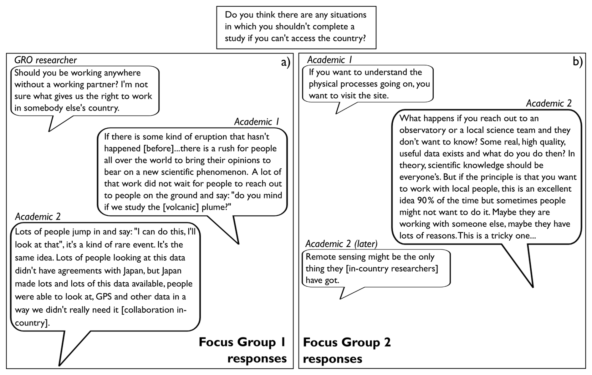
Figure 2Focus group discussion of remotely studying sites without physical access. Part of Focus Group 1 and 2's discussions in response to the question: “Do you think there are any situations in which you shouldn't complete the study if you can't access the country?”
Focus Group 2 participants responded with strong, diverse opinions (Fig. 2). One academic participant (Academic 1, Fig. 2) highlighted the importance of ground truth data – which is usually collected within the study region – for validating satellite-derived results. A second participant countered these opinions by suggesting that some locations are fundamentally unreachable, and that remote sensing is an indispensable tool where topography is high, or the location is too dangerous to visit. A majority of this group's participants, however, felt that a beneficial element of visiting a study region was the natural involvement that researchers gain through local collaborators, field researchers, and the wider community when you are physically on the ground. This majority thought this interaction would benefit both parties in the collaboration. For local people, the collaboration and data sharing by the external researchers are more likely if researchers visit the study site. Meanwhile, the external researcher benefits from learning first-hand how communities are affected by a geohazard. In this FGD, the participants with these pro-collaboration views were mainly non-UK national researchers working in the UK. To counter these positive aspects of visiting a study region, a UK-national academic researcher (Academic 2, Fig. 2) responded with a frustrated statement suggesting that sometimes international researchers are not available or are unwilling to collaborate, and that this resistance may delay scientific progress. As with some of the interview participants, this same UK national academic later said that the strength of remote sensing is that you can monitor places which do not have capacity to measure signals on the ground (Academic 2, later, Fig. 2). Remote sensing by external researchers may therefore offer some benefits to in-country researchers in providing them with geohazard information they would otherwise not have.
3.3 Theme 3: researcher responsibilities towards imaged societies
We asked interviewees: “In the imagery or data that you use, can you observe people or society in any way?”.
Many interview participants said that the data they use is insufficient resolution to identify or image individual people or assets. Within COMET, for example, many researchers work with medium resolution (100 m) Sentinel-1 Interferometric Synthetic Aperture Radar (InSAR) data (see Sect. A for technical guidance). This data can be used to map how fast the ground surface moves over time, sometimes with six day temporal resolution. One interview participant explained that the locations of buildings and settlements can, however, be inferred indirectly through SAR coherence. Another interview participant described being able to see a settlement destroyed by a pyroclastic flow using optical satellite data.
Some participants said that the impacts of people can be identified with satellite data, rather than the people themselves. For example, the movement of the ground downwards over time, land subsidence, can be mapped in space and time using satellite InSAR data. Some of this subsidence, participants explained, is caused by humans abstracting and depleting fluids such as groundwater in the sub-surface.
Some participants compared the data that they are using to services and imagery provided to the public for free through Google Earth or Google Maps. For example, one participant who works with imagery acquired by Pléiades satellites said: “You do not see more [in our optical data] than you could on openly available datasets like Google Earth”, suggesting no ethical issue in working with VHR imagery. Conversely, another participant who also works with this optical data explained that if imagery on Google Earth covers “strategic infrastructure or war zones” then Google may pixelate, for example, an army camp so that no side in the conflict can benefit from this open-access resource.
3.3.1 Imaging illegal or compromising activity
We asked interview participants if they had ever viewed illegal or compromising activity, intentionally or unintentionally, when using satellite data in their research. Three participants who were employed in GROs or industry said that projects they had worked on specifically aimed to research illegal activity in non-UK settings. In an academic setting, one participant said:
Probably yes due to the amount of data we use that something [illegal] has been imaged. This is likely just [for example] small scale logging but [a scientist or data processor] would have no idea. Sure there are ways to find out. If you do not know it is there you wouldn't take any measures against this.
Two other academic participants thought they may have observed illegal activity (for example, evidence of illegal groundwater extraction in land surface subsidence) but it would be difficult to find out without local contacts if this activity was within the law. Three academics said to their knowledge they had not viewed such activity.
One interview participant explained that some satellite data providers restrict access to imagery of contested land. They said:
The German Space Agency has some countries they just don't let data out because there is contested land … for example it is very difficult to get TerraSAR-X data of Ethiopia. And I have had data requests turned down on the Ecuador-Colombia border – which has been a pain – because there has been activity or unrest going on around there.
The participant speculated that this restriction is related to security sensitivities, informed perhaps by space agency military contacts.
3.3.2 Protecting individuals and asking for their consent
If participants said that they could see people, societies, or the impacts of people in their datasets, we asked whether participants took measures to mask or exclude these parts of their dataset from their published work. No participant said that they had taken such measures.
We asked some participants if imaged people are able to consent to satellite imagery being acquired of themselves or their property. All participants that we asked said that people were not able to provide consent. One participant who works mainly with InSAR data to derive surface deformation products said: “these people are not imaged, I would say”. This statement makes reference to the notion that maps generated using InSAR data tend to measure how fast either objects such as buildings or image pixels move over time. These maps do not tend to image people directly.
3.3.3 Focus group discussions
Building on these interview responses, we asked focus groups: “Should remote sensing researchers take measures to keep data that focuses on or images society private?”. Focus Group 1 thought that there are occasions where these measures would be appropriate. One participant opened the discussion by suggesting that parts of imagery not being used in research could be masked (Academic 1, Fig. 3a). However, several participants countered the practicalities of this suggestion, with one asking how private areas would be identified and another pointing out that if, for example, a researcher is mapping exposure of society to a geohazard, then these human-related features cannot be masked (Academic 2, Fig. 3a). A third participant countered this suggestion by emphasising the fact that scientists uncover more information from “raw” imagery through analysis and observations (Academic 3, Fig. 3a). Finally, this group discussed the impact that geohazard science can have on house or insurance prices, and the ethical dilemmas that researchers face when their results could have these impacts. In one instance, the publication of a hazard map in the Azores, one participant said, lead to house prices suddenly dropping. A second participant said that buildings were classed as damaged or not by a geohazard. This damage map was not accurate and caused difficulties with insurers for homeowners when their house was wrongly classified.
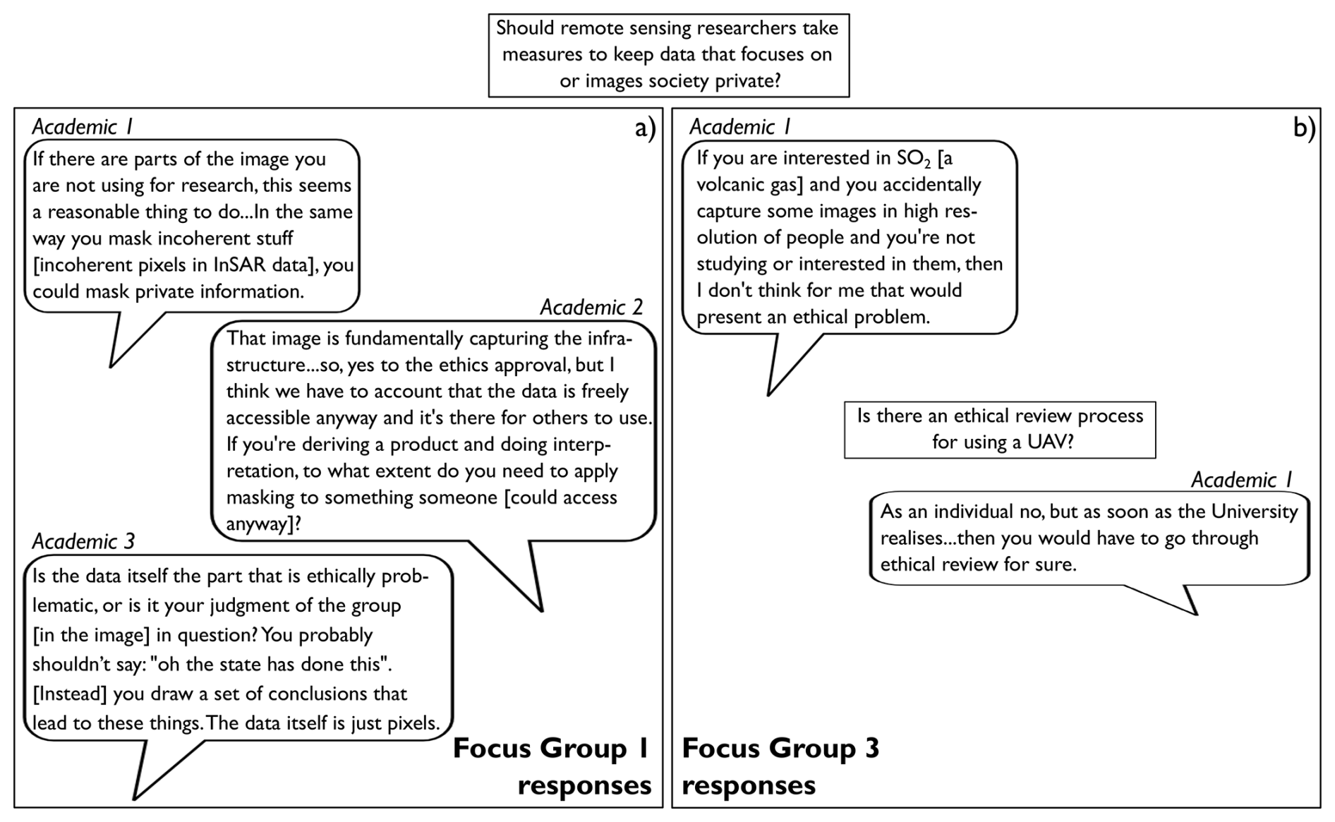
Figure 3Part of Focus Group 1 and 3's discussions in response to the question: “Should remote sensing researchers take measures to keep data that focuses on or images society private?”
A participant in Focus Group 2 suggested that these measures should be taken in accordance with precedence from existing privacy laws. They said:
GDPR type principles come into this … Can you identify people? You should not publish anything that allows identification of individuals. It is precedence.
This suggestion is similar to the precedence logic mentioned by Focus Group 1 in response to their thoughts on ethical review.
A participant in Focus Group 3 suggested that the question of making data private relates to the research intent (Academic 1, Fig. 3b). Other participants appeared to agree with this sentiment. However, the same participant seemed to reconsider their own point of view when considering UAV data. They explained that in the UK, if you have a UAV with a camera, even a toy one, you have to register it with the civil regulation authority. When asked if there is any ethical review process for using a UAV, the participant said:
As an individual no, but as soon as the University realises … then you would have to go through ethical review for sure.
3.4 Theme 4: tensions between desired impact and academic pressures
We discussed with interview participants what they feel “making impact” means for them in relation to using satellite data to research geohazards. We also asked what dissemination and communication methods they felt were the most effective to achieve this impact. For some participants we did not ask this question directly but broadly discussed the topic. To explore the definition of impact further with focus groups, we asked FGD participants directly: “How would you define making “impact” when researching geohazards using remote sensing?” The answers from focus groups, in comparison to interview responses, were more general and less specific to their own day-to-day work. This contrast may be because interview participants had more time to explain their research and how they personally disseminate research outputs, thus they already began thinking reflectively about these ideas. The definition of making impact and the methods of making impact varied with the type of organisation that the participant worked, be it an academic institute, industrial setting, or a GRO. These two items also varied with the geohazard (volcanic or earthquake focus) and region being researched.
3.4.1 Making impact at a GRO
Participants employed at GROs said that they prioritised establishing long-term, personal relationships and co-developing scientific results with in-country partners to make what they perceived as impact. We asked researchers what impact they hoped to achieve through these collaborations. For one participant, this meant collaborators becoming able to process data and publish results themselves to establish research independence. When asked how long it takes to build collaborations to the point of research independence, the same participant said:
I think, at least 10 years, I mean I have already some contact … you probably need [10 years] … it's important keeping that relationship [going] so regular meeting, not just limiting to, let's see, one visit every year, [it] is the daily conversation.
This participant went on to emphasise the need for personal relationships in having this desired impact, saying:
if someone from [my organisation] knew that person [collaborator] for 30 years, then he retired or she retired then that's it. You have to start [the collaboration] again.
3.4.2 Making impact in academia
A Senior Academic who researches volcanoes using satellite data described the contrasting situation in an academic setting. When asked how they personally define making impact, they said:
Well I think it is all coloured by the UK university definition so I have a clear definition of what impact is here, you write a paper and there's a clear paper trail of what connects the results of that paper to a decision that’s made by a decision maker in politics or community civil protection or something like that … Personally I feel like impact is a bit broader than that. As in, if you establish a long-term relationship with people, and you implant a perspective or provide some different data then that does make an impact on their thinking and that is some kind of tangible results in terms of the way a volcano observatory operates.
They explained, for example, that they contributed scientific results that influenced the position of a GNSS site on a volcano. This is a really “critical part of the impact”, they said. Asked how they feel about the contrast between these two definitions of impact, they said:
Yeah I think it's not ideal, I think things that get credit when you have too concrete and too limited a definition of impact are things that have slightly similar horizons and are less ambitious and less risky, and I think it pushes research to be a little bit less adventurous and less exciting if you are focused on trying to demonstrate a specific impact you can actually predict.
3.4.3 Making impact as an earthquake researcher
For academics who study earthquakes using satellite data, making a desired impact can, according to our participants, feel more difficult. One earthquake scientist explained it is easier to make impact as a volcanologist due to the relatively static nature of volcanoes and the help of volcano observatories. In the context of earthquakes, the participant said:
how do you persuade a mayor of a town who is in the position for three to five years to do something for a hazard where the risk is actually quite low? … The danger to loss of life is actually quite small, the risk of it hitting a town in a five year window is small but the costs to move the dial are beyond any budget. How do you reconcile that? That's the biggest challenge [for making impact].
This academic appeared to feel a competing tension in wanting to make their research outputs more useful and usable, their lack of training in doing so, but additionally a frustration in working with social scientists. When explaining a large DRR project and how it works, they said:
I think there is some interesting work going on there. I'd like to be involved with it but I don't really know, I haven't really got the training. So it's kind of making it up as you go along really.
However, when explaining their experience working with other scientists and colleagues who are experienced in DRR, this participant said:
I think that when you start working with social scientists they kind of – depends who they are – whether they want to get things done or whether they are a bunch of social scientists who, if you ask them a question they just ask the assumptions behind your question. If you ask them a question they ask “why have you asked that question”?
3.4.4 The ultimate impact: saving lives
Some academics believe that the ultimate impact of geohazard research relates to saving lives through risk reduction. This impact relates to the ethical value that some researchers feel that geohazard research contributes to society. For example, Focus Group 3's discussion mainly focused on the view of one participant who said:
An obvious one is saving lives. You can use data to assist in risk reduction in challenging places. If you have skills in remote sensing you can transfer these to build capacities in countries and allow local scientists to make decisions. Impact in its purest form is reducing risk.
Similarly, Focus Group 1 discussed having impact meant seeing change in policy or behaviour. For example, one of Focus Group 1's participants described how they worked on a scientific advisory committee for the UK government which provided advice to inform the size and extent of a volcano evacuation zone. This, the participant said, was an example of making direct impact. Group 1 participants agreed that in general some kind of policy, regulatory, or behavioural change is impact.
3.4.5 Strategies for making impact vary by location
The strategy to achieve desired impact varies significantly depending on geohazard location, according to our participants. One academic researching Iran, for example, explained how the ability to collaborate with international colleagues has changed dramatically over time due to the impact of international sanctions. Before 2017, Iranian universities awarded “bonuses” for collaborations with international scientists. Since 2017–2018 this changed completely with the implementation of international sanctions. Now, international collaborations are not offered by European countries, or allowed by Iranian universities. According to the participant, international scientific collaborations are instead established with countries such as Russia with which Iran maintains good relations. The collaborations most heavily impacted by sanctions are those which the participant says are most useful, such as those with Canada, USA, and Europe. The participant said that many scientists have left universities in Iran due to the impacts of these limitations. In times of international sanctions, the participant said that external countries publishing data and publications open-access makes science in Iran easier. Additionally, when asked the best method to exchange knowledge as an international scientist with Iranian people or scientists, the participant pointed towards social media. People in Iran can access some social media platforms, so simplifying results and producing simple maps that can be spread through these platforms should be the first step.
3.4.6 Making impact through social media
Alternatively, many interview participants warned against sharing satellite data related results on social media, especially those related to volcanic unrest. Two Senior Academics who have shared data with societies impacted by volcanic events emphasised the importance of letting volcanic observatories and civic leaders do their job in leading responses to such unrest. For example, one academic said:
You also don't want to stand in front of a volcano observatory and say look if it was me I would call the evacuation off because I don't see anything in the interferograms. Because of course the InSAR is just one strand of all the information they have and all the contextual information they have about the community. So even if you might be scientifically correct, your interpretation is of one dataset and you should never put it out there, you should never suggest an action when there is someone who's job that actually is. You have to support them and not make it harder. So I personally never tweet during a crisis. But I have quite often provided figures for volcano observatories to use. I think that’s the right way round.
3.4.7 Lack of feedback limits research impact
We asked participants if they ever receive feedback from partners or stakeholders that helps improve the communication style or method used to disseminate their research outputs. Many academic participants received limited or no feedback from partners. This is in contrast to those employed in GROs who co-develop research based on interaction with in-country partners over decadal timescales. One academic working on a multi-institute, multi-year project aiming to reduce urban risk, for example, described how in-country partners were built into projects from their inception. This participant's role in this work was to process topographic data and build flood models which in-country partners could not construct due to limited compute power at their institutes. This participant's research was published in scientific papers as well as fed-back to the project organisers. The participant, however, was not aware of how results were eventually communicated to local leaders, explaining they were part of an established framework or “chain” aimed at reaching the end goal. They said:
The further you get to the end goal, the more you lose sight of what happens. Often you don't get feedback of how data is used unless you chase to find out, but this is time-consuming.
Another participant described collaborating with scientists in a country with elevated seismic risk for 18 months, with the aim of training these scientists to implement seismic hazard workflows developed in the UK. The desired impact was for the non-UK scientists to implement these approaches when they returned to their home institute. When asked if they felt this project was successful, the participant said:
I think it was successful in that they had taken up some of the work. They enjoyed what they did. I haven't then followed up to see what they are using, what they learned here, what approaches are they using and implementing. I don't know the true final success.
3.4.8 Focus group discussions
To explore further the most impactful methods of geohazard research dissemination, we asked Focus Group 1: “How should scientists wanting to make the most impact with their geohazard research disseminate their results?”. One academic participant said:
If you rely on journals you reach your peers, a sub-section of media and a further sub-section of the public. [Instead] you must engage with people on the ground. Whether that's directly yourself with communities or better through local agencies who have those partnerships.
Other group members strongly disagreed. Four participants emphasised, as did many interview participants, that communicating with local partners should be the priority and not directly with the public. One participant working in a GRO said that engaging with communities through local agencies can be very difficult, especially if the country is very populous. The participant advised working with various levels and forms of local authority including civil defence and NGOs, the latter of which can have impact as they have more local connections to communities. Another participant also working in a GRO agreed and said:
These things should be framed by local partners relative to the priorities and social political sensitivities … everything that is going on in the local environment that we may not have full understanding of. It has to be in association with user needs and defined really early on in the inception of a project.
The group agreed on the whole that, to usefully communicate geohazard severity, providing a range of uncertainties about future situations has more impact than providing a single future event forecast. To develop these uncertainties, one academic participant suggested expert elicitation. Other suggested strategies to increase research impact included translating research outputs into study region specific languages, as well as sharing data in several file formats.
3.5 Theme 5: the ethical implications of open data
We discussed with interviewees the nature of openly available data, how reliant they are on this resource, and how useful open data is to the global community.
We asked two participants whose academic work focuses on constructing continental scale surface velocity fields if their projects would be possible without access to open-access data. One participant said:
Certainly not to the degree at all. When we used to work [before 2014], the geographical range, the timescales, and amount of data was not a range you would choose because you had to get special accesses [to satellite SAR data] which would include the European Space Agency, which meant it was a barrier to the volume. It slowed the whole process down.
This step change in geographic and temporal scale of SAR research was enabled by Sentinel-1, a satellite which has acquired radar data at near-global scale for over 10 years. We asked another academic participant if a non-expert would be able to use InSAR data (see Sect. A for technical guidance). They said that most people who were an expert in any way would be able to understand and “cope” with deformation measurements, which are the final derived results produced by InSAR time series analysis. However, this participant acknowledged that InSAR data are complicated to interpret, let alone process. They said InSAR processing is a bit of a “dark art” due to the many choices involved in producing interferograms and time series results from SAR raw data. They said:
You can kind of black box it [use default processing chains] but you don't always get the best results.
Finally, a third interview participant noted a change since 2014 in the ability of volcano observatory staff to process InSAR data themselves. They said:
With InSAR these days they [observatories] tend to process a lot of data in house themselves so it's more a matter of giving feedback on what they have got or helping with a bug or helping them interpret it differently … But back in 2014–16 I was processing the data.
In a similar way, a participant at a GRO used open-access data in combination with open-source software to “empower” in-country partners to process data themselves.
3.5.1 Focus group discussions
We asked Focus Groups 1 and 2: “Should remotely sensed data and related products (that focus on geohazards) be openly accessible for all?”
In Focus Group 1, one participant suggested that remotely sensed data should be made available with agreement with local authorities and that, for some regions, you do not want to conflict with these authorities. Another participant suggested that there is a timescale element to this data release and that sometimes volcano observatories will not release data to the public whilst an eruption is ongoing. Finally, a third participant explained that the Spanish authorities have an open data policy with some exceptions. This participant said:
If there is something going on they shut down their web pages, which doesn't help because people get really nervous. But on the other hand, it's always the question do you make it open for amateur interpreters.
In Focus Group 2, participants made several considerations for whether all remotely sensed data should be open or not. One participant firstly suggested that if someone or some company is making money from this data then it should not be open. However, the same participant suggested that if the data is useful and it impacts other people, then this data should be open. The group also made the distinction between data being made open and available as opposed to data being accessible. One participant said:
I think related to hazards the data should not only be made accessible online but be made accessible for the people affected by it. And that usually requires working with other people because that's not something we as scientists are best suited for.
Conversely, a participant responded that data can be wrongly interpreted by the public. They said that volcanologists know, for example, that volcano inflation will not always lead to an eruption. The public may not know this. They said:
My understanding is there should be some proper outreach activities associated with this open-access dataset.
A final participant suggested that if local authorities are responding to a geohazard external to the UK then UK-based researchers working on this geohazard should only publish their results with advice from local authorities.
In this section, we place our results in the context of existing geoethics, ethical-Artifical Intelligence (AI) and DRR frameworks through reference to their principles. The ethical-AI framework we use for reference is the Fairness, Accountability, Transparency, and Ethics framework (FATE; Memarian and Doleck, 2023). We consider three frameworks as each reflects on a different aspect of this study's themes. Geoethics provides disciplinary grounding, FATE provides guidance on data ethics, and DRR literature provides geohazard context.
Geoethics is defined as dealing with the “ethical, social and cultural implications of geoscience knowledge, research, practice, education and communication, and with the social role and responsibility of geoscientists in conducting their activities” (Di Capua and Peppoloni, 2019). The geoethics framework consists of the foundational principles responsibility, dignity, and freedom (Peppoloni and Di Capua, 2021; Di Capua and Peppoloni, 2025) to guide geoscientists toward taking responsibility for the Earth system (Peppoloni et al., 2019). Responsibility in a geoethical context refers to geoscientists being responsible in ensuring scientific excellence in the search for truth, promotion of sustainability, and the transfer of knowledge to colleagues and society (Bobrowsky et al., 2017). Dignity is defined as the recognition of value in beings and environments beyond oneself, and implementing that recognition through research practice (Peppoloni and Di Capua, 2021). Freedom refers to the possibility of individuals to choose between ethical alternatives. Without freedom one cannot act responsibly (Bobrowsky et al., 2017).
The use of AI (including machine learning, deep learning, and convolutional neural networks) in satellite data processing and analysis has been accelerating over the last two decades (e.g. Hall et al., 2022). A growing bed of literature aims to understand emerging ethical issues in using AI in Earth observation applications (Kochupillai et al., 2022; Micheli et al., 2022; Yazici, 2025). Consideration of ethical-AI in remote sensing was outside the scope of this study. However, ethical-AI frameworks present principles which intersect our findings and discussion. Discussing our results in reference to the “Fairness”, “Accountability”, “Transparency” and “Ethics” (FATE) principles (Memarian and Doleck, 2023; Inuwa-Dutse, 2023), for example, provides a framework for evaluating data-driven, remote sensing research practices, where decisions about data access, processing, and dissemination have direct societal consequences. In the context of this study, Fairness refers to equitable access and benefit to research outputs; Accountability refers to researchers' responsibility for the consequences of their work; Transparency refers to researchers having clear methodologies citing limitations and assumptions; and Ethics to alignment of research approaches with broader societal values.
Disaster Risk Reduction (DRR) refers to the development and application of policies, strategies, and practices to reduce vulnerabilities and disaster risks throughout society (Twigg, 2015). The Disaster Studies Manifesto: Power, Prestige and Forgotten Values (Gaillard et al., 2019) provides a new academic “opening” (Khan, 2022) to address power imbalances and inequity in DRR practices. The Manifesto's concerns with power imbalance and knowledge equity directly reflect the geoethical principles of dignity and freedom, as well as the FATE principle of Fairness. We also consider The Sendai Framework for Disaster Risk Reduction (Sendai Framework; UNWCDRR, 2015) in our discussion.
4.1 Open-access vs equity of geohazard satellite data
This section considers our participants' ethical perceptions of open-access data, and how existing structures maintain inequity among geohazard stakeholders. These ideas are considered in reference to the geoethical value of responsibility, and the FATE principles of Fairness and Transparency.
Since 2014, our participants explained that ESA's decision to publish open-access vast volumes of satellite data in near-real time through the Copernicus programme (Jutz and Milagro-Pérez, 2020) resulted in a step change in how geohazard remote sensing researchers conducted their research. This change made possible research spanning continental spatial scales and decadal temporal ranges. Moreover, Copernicus data has consistent and fine temporal resolution (up to 5–6 d) compared to previous missions (e.g. ESA's ENVISAT and ERS missions; Louet and Bruzzi, 1999; Duchossois and Honvault, 1981). The number of data downloaded through the Copernicus programme has increased 133 %, 2016–2019 (Wright, 2024). As well as ESA data, NASA made openly available in 2008 the entire Landsat archive and future acquisitions (Woodcock et al., 2008).
However, participants and the wider community still identify barriers to accessing, processing, and interpreting this vast open-access satellite data catalogue (Zebker, 2017). Many of our participants suggested that researchers in the Global South historically or currently have reduced capacity to download and store satellite data compared to Global North colleagues. Additionally, due to reduced training and compute power, these Global South colleagues have reduced capability to analyse and process satellite data and derived products.
For InSAR data in particular, there is a long processing chain for constructing interferograms and InSAR time series from the raw data format that ESA releases. Higher level data products such as interferograms and deformation time series (see Sect. A for technical background) are used by geohazard researchers to monitor and research geohazards. These products are not released by ESA meaning researchers must use a processing chain to produce them. This InSAR processing chain involves several choices including which software to use (Li et al., 2022), whether to construct interferograms and/or time series data yourself or to use openly available products (Lazecký et al., 2020; Costantini et al., 2021), and which processing parameters are most appropriate for the region of interest. These choices depend on research budget and time, compute ability and capacity, as well as the study region characteristics. Some researchers with reduced compute power and time may choose, according to our participants, “black-box” processing approaches in which SAR data is processed using default parameters. These approaches may not provide the most accurate, noise-free results, potentially reducing the result usefulness, certainty, and interpretability. Accurate interpretation of satellite data is critical in the event of an evolving geohazard related disaster or hazard forecasting (Tralli et al., 2005). Reliance on black-box processing strategies limits research Transparency, a FATE principle (Memarian and Doleck, 2023) which requires that analytical processes are understandable or at least accessible to those affected by the research outputs. When processing choices are opaque, decision makers and local communities relying on derived products cannot meaningfully evaluate their reliability.
Furthermore, these barriers identified by our participants imply a lack of equity in accessing and processing InSAR data to monitor geohazards. Equity can be defined as existing when “everyone is able to achieve equal outcomes through equal access to opportunities and resources and to foster a clear sense of belonging once those opportunities or resources are obtained” (Babinski, 2021; Nelson et al., 2022). This issue aligns with the Fairness principle of the FATE framework, which holds that technologies should be accessible and beneficial across diverse user groups, without reinforcing existing disparities in resources or capacity (Memarian and Doleck, 2023). From our participants' experiences, a lack of remote sensing training, research time and budget, and overall research capacity limits the equity of open-access satellite data for geohazard research, undermining this fair access to remote sensing practices.
4.1.1 Improving equity in satellite data for geohazard research
There is evidence from our participants for improvements in equity among the global geohazard satellite remote sensing community. For example, over the last 10 years, one academic participant described how their relationship with a volcano observatory has evolved from the participant processing satellite data to providing results to observatories, to observatory staff now processing data themselves. The participant now supports observatories more with providing feedback on their work and result interpretation. This relationship evolution conforms with ambitions of the Disaster Studies Manifesto (Gaillard et al., 2019), which states local researchers should be encouraged to lead research proposal development and design. Additionally, this researcher demonstrates geoethical responsibility for knowledge transfer and capacity building, rather than knowledge extraction. This change, the participant suggested, may relate to the increased volume of open-access data for volcano observatories to use.
Recent developments at the space agency level will improve the global equity of satellite data for geohazard research. Firstly the European Ground Motion Service launched in 2022 serves open-access land-surface motion data for much of Europe (Solari et al., 2022). This service bypasses the need for InSAR compute power and expertise, improving equitable access to InSAR derived ground motion data for Europe. Secondly, at a global level, scientists involved in the mission of the newly (2025) launched NASA-ISRO SAR (NISAR) SAR satellite (Rosen et al., 2017), have aimed since mission inception to improve accessibility and usability of NISAR products (Zebker, 2017). The NISAR team aims to deliver “ready to use” SAR and InSAR data without need for further processing, with open-access SAR/InSAR products derived from NISAR using as little storage volume as possible. The NISAR team has also conducted capacity-building efforts (Meyer et al., 2024), released sample data products ahead of launch (Zebker, 2017), and developed cloud-based training tools (Meyer et al., 2021). These efforts improve Fairness and Transparency (in reference to the FATE framework, e.g. Memarian and Doleck, 2023) of open-access SAR/InSAR products for geohazard science, through reducing the compute and storage burden for geohazard scientists with limited storage, compute, or technological capacity, therefore improving accessibility and inclusivity of the field.
Overall, these examples demonstrate the responsibility which geohazard researchers hold in providing equitable access to understanding geohazards. Due to increasing efforts to improve equity of satellite imagery through space agency open-access schemes, and step-changes in the accessibility of software available to process and thus access InSAR data products, barriers to geohazard remote sensing are beginning to reduce. Due to geoscientists' technical and scientific knowledge of geohazards, in a geoethical framework, geohazard scientists continue to have an essential role in improving equity to enable agency in remote sensing processing for researchers studying geohazards.
4.2 Ethical review, research, and responsibilities in satellite geohazard research
This section frames participants' perceptions of ethical review in the field of geohazard remote sensing through the geoethical principles of dignity and responsibility, and the FATE principle of Accountability.
Firstly, from our results, there is a clear misunderstanding from particularly the academic geohazard remote sensing community around the purpose and need to consider research ethics when conducting remote geohazard research. We find that remote sensing scientists, when asked about research ethics, consider risks associated with personal privacy and high resolution imagery rather than ethical risks relating to their research methodology, research aims, and intended or actual research impact. Moreover, ethical review is viewed by some academic participants as an administrative checklist with black and white permissions that seeks to limit research freedoms. Such concerns are referred to extensively in ethics governance literature as “ethics creep” (Haggerty, 2004; Head, 2020; Page, 2026). Such creep describes how formalised ethics review systems have prioritised bureaucratic compliance over true ethical reflection (Haggerty, 2004). Our academic participants reported that, in their institutions, ethical review was optional and it was the individual researcher's responsibility to decide whether to conduct a review. Individual researcher judgment also plays a significant role in industrial and GRO ethical review settings. These participant perceptions highlight a lack of geoethical responsibility, as researchers are left to self-determine ethical risks without the training or frameworks to do so effectively. This deficit is compounded by a lack of institutional Accountability, where ethics review boards do not require geohazard remote sensing researchers to formally consider the broader societal implications of their research design or dissemination strategies.
4.2.1 Reframing ethical review for geohazard science
Historically, Bond (2012) explains, the need for ethical review in research evolved from a need to avoid “atrocities” such as the Nuremberg trials in Nazi Germany (Kennedy and Grubb, 2000). These beginnings have meant that the principles underlying ethical review for many research disciplines still have their foundations in biomedical science. This medicine-centrist ethics system comes at the frustration of some social scientists who feel their work is unnecessarily upheld to the standards of medical experimentation (Schrag, 2011), with an “excessive fixation on harm avoidance” (Bond, 2012). However, this focus on harm avoidance can be reframed to better consider social and geophysical science. Bond (2012), for example, suggests ethical review should evaluate whether a planned study will achieve its desired impact whilst maintaining the respect, rights, and well-being of human participants and others affected by the planned research. Bond (2012) further suggests that researchers must take sufficient responsibility for the knowledge and findings that they present. These ethical considerations must be balanced against the “stubborn persistence of prioritising the quest for knowledge” (Bond, 2012) that some of our participants expressed. For example, many academic research participants in this study considered their ultimate end goal of “saving lives” or “influencing policy” the ethically superior motive for studying geohazards of their choosing. This perspective reflects the openness of vast satellite data repositories since 2014, with remote sensing scientists perceiving this lack of data restrictions as positive permission to conduct geohazard research with no spatial restrictions. However, consideration should be taken to align the ethical considerations of geohazard remote sensing with those suggested by Bond (2012). Geohazard researchers should decide the ultimate, desired impact of their study; if their study will achieve or contribute to this impact; and, in contributing to this end goal, if their research will affect the well-being of researchers and, in particular, imaged communities, even if these communities do not participate directly in the planned research. This three part consideration cements geoethical responsibility in geohazard study design, requiring researchers to account for the full consequences of their work rather than stopping at publication. In geoethical terms, this reframing of ethical review reflects the principle of dignity: the requirement to actively recognise and implement the value of imaged communities, treating them not as data sources but as stakeholders whose communities may be affected by research outcomes.
4.2.2 Engaging in existing geoethical and DRR frameworks
Geoethical frameworks highlight “prevention” as one of the fundamental values underpinning geoethical practice (Peppoloni et al., 2019). Prevention refers to activities and tools which prevent processes happening or prevent resulting harm (or harm minimisation). In the context of geohazard remote sensing, this value includes our participants desires' to “save lives” and “impact policy”, as well as contribute to DRR. The Sendai Framework for Disaster Risk Reduction (Sendai Framework; UNWCDRR, 2015) is one framework which guides DRR principles and practice globally, aiming to strengthen DRR to reduce loss of lives and assets from disasters worldwide, 2015–2030. The Framework outlines four “Priorities for Action” to inspire focused action on contributing to DRR, with the first being “Understanding Disaster Risk”. To achieve this priority, enhanced access and sharing of “remotely-sensed Earth and climate observations” are specifically mentioned. Furthermore, academia is called upon to focus research on disaster risk factors and scenarios in the medium and long term, as well as to support the interface between policy and science decision making. If geohazard research is communicated and disseminated effectively with policy and science decision makers as proposed by the Sendai Framework, this research is more likely to contribute to risk reduction and “saving lives”, perhaps through policy change. If these aims are achieved, geohazard remote sensing research impacts will more closely align with geoethics and existing DRR frameworks. Conversely, poorly communicated and disseminated research may have the capacity for DRR due to its scientific excellence but is less likely to contribute to DRR or support the Sendai Framework. It is therefore researchers' responsibility to follow the priorities of the Sendai Framework to contribute to DRR by enabling prevention.
Geoethical responsibility requires individual researchers to consider the broader consequences of their research choices and to actively contribute to communicating findings to relevant decision makers. The Sendai Framework nonetheless recognises that ultimate responsibility for reducing disaster risk lies with states rather than individual researchers (UNWCDRR, 2015). These two scales of responsibility are complementary: individual researcher accountability supports the systemic frameworks within which states act. Moreover, each actor in a disaster and hazard context has specific roles and responsibilities and is part of the “defence system” against potential risk (Peppoloni et al., 2019). This need for researchers to engage with states and relevant decision makers is exemplified by the ESPREssO project. In 2020, the ESPREssO project (Zuccaro et al., 2020) aimed at a European level to identify gaps and priorities for not only DRR but also Climate Change Adaptation, and Disaster Risk Management within the Sendai Framework. They found that despite the “overwhelming amount of information available through satellites, remote sensing, public repositories, social media, data are scattered among multiple sources, thus hampering their effective use and translation into actionable information for decision makers to support their activities in the whole emergency cycle”. This fragmentation of geohazard data represents both a Transparency failure and an Accountability gap. Derived products are not accessible or transparent to those who need them, and there is no formal mechanism to ensure research outputs reach the relevant decision makers.
COMET themselves acknowledge the potential for their datasets to support DRR, but find that their communication strategies through, for example, Twitter (now X) are more oriented to disaster and event response rather than long-term hazard preparedness or DRR (Watson et al., 2023). Both the data fragmentation failures and this communication gap can be addressed by geohazard scientists through consideration of their role in Sendai and other DRR frameworks. Training to improve geohazard remote sensing researcher awareness of their roles in these frameworks is critical to achieve this consideration. Furthermore, communication efforts should consider potential to support both short-term and long-term DRR, perhaps through collaboration with local institutions, or UK-based institutions who have in-country contacts. Such action will reduce disaster risk and academic neocolonialism (Gomez and Hart, 2013), as well as improve researcher Accountability.
In summary, our participants demonstrate that the academic geohazard remote sensing community has a narrow framing of ethical review, reflecting a – perhaps unintentional – reduction in dignity and responsibility towards imaged communities and geohazard stakeholders. Reframing ethical review around Bond (2012)'s three part consideration would improve application of these geoethical principles, as well as improve institutional Accountability and harm minimisation.
4.3 Experiences of collaboration and communication
This section considers participants' reflections on their ability to communicate and disseminate their research outputs, and how their communication efforts contributed to DRR or “saving lives”. Effectively communicated research is more likely to contribute to the fundamental geoethical value of “prevention”, demonstrate researcher Accountability and geoethical responsibility, enable Fair data sharing, and maintain Transparent communication channels (with Accountability, Fair, and Transparent derived from the FATE framework; Memarian and Doleck, 2023).
4.3.1 Challenges in geohazard research collaboration and communication
Our participants felt strongly that the difficulties in forming and maintaining in-country collaborations – particularly in academia – inhibit academic contribution to DRR. For example, three interview participants mentioned that at least ten years of collaboration is required to influence policy or changing societal attitudes. This 10 year timeline is in tension with the lifetime of the research grants under which which many of our participants operate. For example, our participant who worked with seismology colleagues in Central Asia now lacks funding and thus time to continue their project development outside of the initial, funded 18-month collaboration time-frame. This tension between the timescales required for meaningful collaboration and those imposed by grant funding represents a constraint on researchers' freedoms to act on their geoethical responsibility to in-country communities.
There is academic pressure, as another participant explained, to focus on generalised, globally applicable, world-leading research rather than localised, small-scale, research collaborating with local decision makers on, for example, volcano monitoring. In the UK, this pressure often relates to the REF (Research Excellence Framework, e.g. Torrance, 2020): the method through which academic research excellence is assessed. At a global-scale, our participants reported that the academic community can be dismissive towards more applied, local-scale geohazard research such as volcanic monitoring. Once researchers prioritise communication of their research in a global academic setting, therefore, there can be little time or funding to focus on more community-centric research and communication. Academic pressure to produce world-leading research in short timelines can therefore drive academic geohazard scientists towards conducting fully remote, globally applicable research without engaging with in-country partners, leading to academic neocolonialist practices (Gomez and Hart, 2013). These practices are at odds with academics' ethical desires to make a meaningful difference to communities vulnerable to geohazards. According to our participants, some researchers feel significant guilt towards the consequences of failing to communicate, for example, earthquake hazard to local authorities. This academic motivation to conduct high-impact work and seek prestige at the expense of collaborative disaster studies with local researchers is also as a concern in the Disaster Studies Manifesto (Gaillard et al., 2019). In a geoethical framing, the prioritisation of globally oriented scientific outputs over science with local impact demonstrates a dignity failure: the knowledge, needs, and priorities of communities most vulnerable to geohazards are least valued by frameworks such as REF. We recommend a change in policy should be considered to support researchers in making meaningful contributions to geohazard risk reduction. REF Impact Case Studies, for example, could be less heavily graded on perceived global impact but instead value local impact. Such local impact could be driven by involving in-country stakeholders from project inception. This early-stage engagement should be accompanied by structured frameworks (such as theory of change models, e.g. Funnell and Rogers, 2011; Reinholz and Andrews, 2020; Glasgow et al., 2017) that embed feedback loops and impact estimation into the project design from the outset, rather than treating impact assessment post-study. This approach reflects a widely recognised challenge across grant-funded research, where tracking and delivering real-world impact remains difficult without such mechanisms being proactively incorporated.
4.3.2 Varied collaboration experience by application
Where efforts were made by our participants to better pin-point effective research dissemination to target in-country researchers or policymakers, some academics remained unsure how or if their disseminated research did impact communities or policymakers due to a lack of feedback back up the “chain” of communication to the researcher. This lack of feedback represents a failure in Accountability (related to FATE; Memarian and Doleck, 2023), where researchers cannot demonstrate whether their outputs reached or benefited communities they were intending to support. This feedback failure also undermines Transparency as, without feedback, assumptions and limitations of satellite-derived products are never tested in local realities. We do find that some researchers, particularly working in volcanology, were able to engage effectively with local, in-country actors due to the establishment of volcanology observatories and associated worldwide volcanology networks. Several volcanologist participants could point to specific examples of how there research or expertise influenced, for example, the boundary of an exclusion zone or the position of geophysical instrumentation. This influence contrasts significantly with that of earthquake scientists who found it difficult to engage with local decision makers when the probability of an earthquake rupture is so low in the short-term that earthquake risk is a low priority for policymakers, despite the potential physical damage and economic cost to communities being potentially significant.
4.3.3 Successful collaborations by government research organisations
Achieving long-term, in-country engagement, was more successful for participants working within GROs than academic settings. In these organisations, local partnership and engagement, our participants communicated, was more commonly practiced. GRO participants were aware of the complexity that international collaborative relationships can entail, especially when working with complex societal structures. Additionally, the approach to collaboration by GROs was different to academics. GRO participants focused on little and often engagement with in-country partners over many years to establish personal connections. Collaboration focused on co-development and co-production with GRO scientists working towards in-country partners establishing research independence, representing geoethical dignity in practice. Research outputs from this co-produced research, these researchers explained, are more useful, useable, and used by societies vulnerable to the researched hazards.
Such practices are key in decolonising knowledge production (Khan, 2022) and reflect the geoethical principle of responsibility, ensuring that knowledge about geohazards in the Global South is produced with rather than about these communities. Khan (2022) defines decolonisation of knowledge as:
An active, conscious and deliberate practice in the pursuit of truth and knowledge, which recognises the plurality and/or diversity of knowledge bases across the world; with an emphasis on knowledge rooted in grassroots communities, that is effectively integrated in both the acquisition and production of knowledge.
In disaster and geohazard remote sensing contexts, the need for knowledge decolonisation is clear. Disasters mostly take place in Global South communities, whilst representation from people living in these communities in western disaster literature is minimal (Khan, 2022). In geohazard remote sensing, this pattern is mirrored, with the dominant direction of satellite data knowledge transfer being from Global North to South. Global South knowledge has been critical in, for example, local adaptation strategies emulated in the Global North formed by the lived realities of local communities affected by disasters in the Global South. These dynamics demonstrate that more needs to be done to improve inclusivity of geohazard remote sensing, to better balance whose knowledge is legitimised and whose is not, and increase the dignity with which studied communities are treated.
4.4 Post-disaster publication gold rush – a neocolonialist practice?
In this section we consider the ethical implications of post-disaster publication practices through the geoethical principles of dignity and responsibility, and the FATE principle of Accountability.
Academic participants' experiences of collaboration are mostly through funded, time-limited projects or through rapid, short-term action in response to specific disasters. For example, Focus Group 1 identified hypothetical and real examples where academic researchers “rush” to study a rare, unique event which has perhaps not been observed during the modern satellite era. These participants explained that if open-access data is available during such events, then in-country collaboration is not required nor sought. Indeed, one participant said “work did not wait” for external researchers to reach out to in-country scientists. These behaviours show the priority that some researchers place on scientific advancement over local collaboration and knowledge transfer. Collaboration with in-country scientists is seen by some UK researchers as a gateway to data rather than an opportunity to gain local insight into evolving hazards and conduct knowledge transfer. This UK researcher viewpoint reflects a failure of geoethical dignity: in-country scientists and communities are seen as means to a scientific result rather than recognised as stakeholders whose knowledge and participation have intrinsic value.
Such “gold rushes” for data and publications in the immediate wake of disasters are well documented. Gomez and Hart (2013), for example, note that the number of articles available on Scopus which feature the word “tsunami” increased 10-fold between 2004 and 2005 following the Sumatra-Andaman earthquake and tsunami disaster of December 2004 (e.g. Fujii and Satake, 2007). The authors argue that this voluminous post-event literature is often neither of high quality nor contribution to scientific progression. Fisher et al. (2021) reflects on a similar phenomenon for archaeologists who conduct remote sensing studies. They explain that, unlike in-country fieldwork, remote sensing does not require engagement with local regulatory frameworks. This lack of engagement shifts power towards the external researcher, placing them with full control over data and narratives, and thus bringing risks of digital colonialism (or data colonialism: the reinventing of colonialism in the Global South through the domination of digital technology; Kwet, 2019; Couldry and Mejias, 2019). This power shift also enables researchers to avoid Accountability for how their research affects the studied country. In a DRR context, the Disaster Studies Manifesto cites concern for researchers who do not engage with local frameworks and communities. Their research risks being uninformed by local realities, meaning that the knowledge of people who experience geohazards is not incorporated into geohazard research (Gaillard et al., 2019).
A rush to publish disaster related research may also come with risks for the geohazard researcher. For example, a Mw 6.3 earthquake struck the city of L'Aquila, central Italy in April 2009, killing over 300 people and injuring 1500 (Walters et al., 2009; Alexander, 2010; Di Capua, 2013). In the wake of this disaster, six scientific members of the Major Risks Committee of the Italian Government and a researcher at Istituto Nazionale di Geofisica e Vulcanologia (INGV) were found guilty of contributing to many deaths due to their inappropriate communication of appropriate seismic hazard and vulnerability (Di Capua, 2013). Geoethical reflections on these events cite a need for improved quality of scientific communication by geohazard scientists, using audience appropriate language that is still scientifically correct, as well as a commitment to conduct reliable, updated scientific research with uncertainty and error evaluation (Di Capua, 2013). Furthermore, relationships with media and policy makers must consist of sharing operational protocols and establishing defined roles and areas of expertise. This example represents a failure of both geoethical responsibility and dignity. Scientists failed in their geoethical responsibility to communicate findings accurately and with appropriate uncertainty, and in doing so failed to respect the dignity of a community whose right to informed decision making about their own safety was compromised by inadequate scientific communication.
There is existing awareness among some of our participants of their scientific responsibility during disasters. One interview participant, for example, described how during the Türkiye-Syria earthquake in 2023 (e.g. Naddaf, 2023), UK-based remote sensing scientists communicated any scientific results directly to Turkish scientists, being conscious not to disrupt or confuse communications from local responders. This practice conforms with geoethical recommendations (Peppoloni et al., 2019). Participants recognised these results should be fed through established channels directly to local decision makers, and researchers should not, for example, provide opinions to media on, for example, when an earthquake will rupture. We found that these behaviours were learned informally between colleagues and through observation of events such as those in L'Aquila. Formal training to guide geohazard scientists' responses to disasters, as well as their contributions to scientific publications in the “gold rush” wake of such events, should be implemented to formalise these practices.
4.5 Geoethical decisions are context dependent
In this section, we consider how the geoethical principle of responsibility, and the FATE principle of Accountability, must be understood as context dependent rather than fixed standards. We discuss how technological evolution, changing political attitudes, and varying societal expectations affect what is required of geohazard remote sensing researchers.
Geoethics varies in space and time as social, political and economic contexts that inform these ethics evolve (Peppoloni et al., 2019). Therefore, decisions and actions taken by geohazard researchers that are informed by geoethical principles (such as dignity and responsibility) are likely to vary in space and time, even if the ethical dilemmas themselves remain constant. Researchers must therefore continually reflect, asking what is the appropriate ethical choice given the current context. This context dependent ethical thinking has historical precedence in remote sensing. For example, in World War I, planes carrying cameras frequently infringed on national airspace as, up to that point, there had been no international agreements governing air space use by foreign states (Wasowski, 1991). This changed in 1919 with the Paris Convention, which stated that a nation's sovereignty exists above all territory that it controls. In relation to remote sensing, however, it was not until World War II when the military importance of aerial imagery was demonstrated that the 1944 Convention of International Civil Aviation granted contracted states the ability to prohibit operation of imaging devices within their airspaces. This example demonstrates how society has historically been ethically and legally responsive rather than preemptive of remote sensing advances.
Extending this logic to the present day and our study, several participants said that they did not consider people or society imaged in their research to be an ethical issue due to image resolution being relatively coarse (tens of metres spatial resolution). However, satellite image spatial resolution used to research geohazards is constantly improving due to advancing technological capabilities. Moreover, increasingly higher resolution imagery is always becoming available to more scientists. For example, in 1995 CORONA imagery (CORONA satellites acquired imagery 1958–1972; Cloud, 2001) was declassified and released for public access. The KH-4B satellites (1967–1972) of the CORONA programme acquired images with spatial resolutions of up to 1.8 m (Goossens et al., 2001). This images resolution was far superior to any publicly available satellite imagery at the time of CORONA imagery acquisition (80 m, 1972–1982, Landsat 1–3; 30 m from 1982 with Landsat-4; Williams et al., 2006; Goward et al., 2006). It was not until nearly 30 years after the KH-4B satellites were decomissioned in 2000 when satellite data became commercially available at spatial resolutions comparable to those possible since 1967 under the CORONA programme (IKONOS-2, 1 m resolution). Today, satellite data acquired at ∼1 m resolution or less is still only available for military use, governmental use, through commercial agreement (Dumery et al., 2018), or through data agreements related to scientific goals such as the Committee for Earth Observation Satellites (CEOS; Lowenstern et al., 2022). This historic technical and open-access trend in satellite imagery resolution implies that individuals may be increasingly identifiable in satellite imagery that is available and used by UK-based scientists in geohazard research. Future satellite imaging technologies may include Synthetic Aperture Laser, for example, which is capable of imaging motion at sub-millimetre spatial resolutions (Turbide et al., 2017). These examples demonstrate the need for geohazard researchers to continually evaluate their responsibilities and actions in the face of new technologies. One industry participant said that as VHR imagery is becoming more accessible, there is increased consideration within industrial settings that actions should be taken to mitigate against potential ethical risks. This concern is reflected in emerging calls for dedicated ethical and regulatory frameworks which govern high-resolution satellite imaging (Yazici, 2025). This industrial action and increasing calls for regulation demonstrate Accountability in the remote sensing field: research bodies are beginning to proactively consider ethical risks before they are required by regulation.
In some cases, ethical risks are mitigated before researchers receive imagery. In the case of CORONA, for example, researchers' ethical reponsibilities were reduced due to the time-lag between data acquisition and release. Other VHR satellite imagery comes with restrictions related to commercial licenses (Dumery et al., 2018). Some imagery capturing conflict appears to be, according to one of our participants, rarely released to scientists by imagery providers due to. However, some VHR imagery use may not be commercially restricted or, even if restricted by a license, publishing derived results may be permitted. These final examples leave some ethical responsibility with individual researchers and research groups. Scientists must decide whether sharing their derived results in publications or in data portals poses any ethical risks. This responsibility is only likely to increase as the satellite imaging power increases.
Aside from spatial resolution, political and societal attitudes influence which ethical risks are perceived to be acceptable in the context of geohazard research. Several participants with longer remote sensing careers noted a change in attitudes towards the ethics of “parachute science” and the involvement of local actors when conducting remotely studying geohazards using satellite data. One participant noted how now compared to twenty years ago, researchers in ex-colonial nations such as the UK are more aware that conducting research in another country, particularly if that country was previously a colony such as India to the UK, would appear colonial in nature. This participant's views highlights how geohazard researchers' attitudes towards remotely conducting research have changed over time, being shaped by changing societal perspectives and a growing awareness of the need to decolonise research practices (Khan, 2022). This growing awareness of colonial implications also reflects an evolving recognition that communities have a claim to freedom involving participating in and benefiting from research conducted about them, rather than being passive subjects of external science.
These examples demonstrate that ethical principles are not fixed obligations but must continue to be reinterpreted and applied to remote sensing as technologies and societal attitudes evolve. As such, as highlighted by Peppoloni et al. (2019), real ethical dilemmas have no perfect solution. The solution is that which is deemed most acceptable in the current economic, social, cultural, and environmental context.
4.6 Consent of imaged societies
This section explores participants' perceptions of consent and privacy in satellite remote sensing through considering geoethical dignity and FATE principles Accountability and Ethics.
We explored if people and societies captured by satellite imagery provide their consent, and how our participants consider consent in their work. In qualitative research in social and medical sciences, studies must gain consent from human participants for their work to be ethically favourable, however difficult it is to receive this consent (e.g. Speer and Stokoe, 2014; Miller et al., 2012). In contrast, it has become customary international law that any nation has the right to overfly another by satellite without seeking permission. This lack of permission follows no significant objections to non-military satellite flights impinging on national airspaces since 1957–1958 (Wasowski, 1991). This lack of positive consent has translated to the present day use of satellite data by researchers. All interview participants said that people and society imaged by satellite data at whatever resolution had no say in whether this imagery was acquired. This complete absence of consent represents a structural failure in dignity. Imaged communities do not have meaningful agency as to whether this data about them is collected, how it is analysed, or how the results are published and used.
In general, participants in FGDs and interviews did not see the need to take precautions to protect people or societies captured in their results, as relatively coarse imagery (5–56 m) records infrastructure rather than individuals. Participants used the example that Google Earth provides access to imagery which is not dissimilar in resolution to the highest resolution imagery available to researchers, implying that researchers are justified to not take measures to protect societies in their imagery if similar products are openly available elsewhere. However, this confidence that resolution alone ensures ethical safety is perhaps not supported by a second participant example. Another interviewee said that Google does take active measures to pixelate regions where harm may result, such as conflict infrastructure. Furthermore, the identification of human-driven subsidence by groundwater depletion, demonstrates that the actions of communities could be derived from satellite derived products without individuals or communities themselves being directly identifiable. Spatial resolution is therefore an unreliable proxy for ethical risk. As in Sect. 4.5, this dismissal for taking precautions when using high resolution imagery implies a lack of dignity towards imaged communities. These communities may still have interests in how satellite data is used beyond whether individuals are identifiable.
This argument is supported by a participant in Focus Group 3, who argued that the raw imagery does not raise ethical issues, and that risk emerges only through interpretation (Academic 3, Fig. 3a). This position is supported by positionality literature, which argues that the data does not speak for itself but is always influenced by the researcher's assumptions, analytical choices, and geopolitical position (Sultana, 2007). This argument highlights that, as researchers analyse and derive more information from raw imagery than is visible in the data itself, new ethical risks are produced that did not exist prior to image analysis. The Azores hazard map and its inaccurate damage classifications described by Focus Group 1 participants illustrates this (Fig. 3). The data itself did not cause harm: the hazard map derived from data did. Ethical responsibility and critical ethical reflexivity is therefore needed throughout the study design and research process, from decisions on study region selection and analytical choices, to dissemination and publication. As communities are captured without consent or sometimes knowledge of satellite imaging systems, both geoethical responsibility and Accountability of researchers is heightened. Researchers must take accountability for the consequences of deriving and publishing information about communities who have had no opportunity to consent to or influence the research.
This section overall demonstrates that the absence of consent mechanisms in satellite remote sensing creates a deficit in structural dignity. Addressing this deficit requires geohazard researchers working with satellite data to better understand their ethical responsibilities for protecting the well-being of observed societies, especially as consent is neither asked for nor received. These consent and privacy could be built into an ethical review for remote sensing studies which avoids checklist-style reflection (Haggerty, 2004; Head, 2020).
4.7 The need for remote geohazard research and monitoring
In contrast to the preceding sections, this section considers the ethical justification for remote geohazard research conducted without in-country collaboration. We consider this justification in reference to the geoethical principles of responsibility, dignity, and freedom. In cases where structural, political, and practical constraints sometimes make collaboration impossible, we consider what ethical obligations remain for researchers.
On the whole there was recognition by our participants in academia, industry, and GROs that long-term engagement with in-country scientists and decision makers would improve the quality and relevance of research to communities, as well as improve research impact. This recognition is aligned with the recommendations of the Sendai Framework as well as the geoethical principle of responsibility: researchers have an ethical responsibility to consider how their research outputs are relevant to vulnerable communities. However, as highlighted by our participants, in some contexts there is a need for remotely studying geohazards without in-country partner engagement. On a practical level, for example, some mountainous regions of the world have extreme terrain and climate which puts in-field researchers at risk. Additionally, openly available satellite imagery can be used to mitigate against risks that researchers face, including limited access to study sites during a global pandemic.
Furthermore, remote sensing studies have value in reducing disaster risk even if collaboration with in-country partners is not possible. This is particularly the case for researchers in regions which face difficulties establishing international collaborations. These difficulties can limit the quality of geohazard research outputs from these regions. As suggested by our participants, some in-country scientists lack time and resource to invest in international collaboration. In these cases, in-country scientists may welcome research by external scientists to support DRR, despite their inability to contribute to it. Political factors may also limit the ability of in-country scientists to collaborate internationally. For example, Iranian scientists are limited to collaborating with scientists from certain regions due to international sanctions. Therefore, research conducted outside of Iran using satellite data without engaging with local partners is welcome, our participants report, by Iranian scientists to further understanding of Iranian geohazards. In these examples, international research without collaboration is favoured by in-country scientists. UK researchers should still consider how working without in-country partners might impact the quality and impact of their work, and how these impacts can be reduced where possible. In addition, the dignity of in-country communities and scientists can be upheld by making sure results are accessible through appropriate channels. For example, perhaps collaborations can be made with Iranian researchers who work outside of Iran. These external Iranian researchers may be better informed about the most appropriate and effective communication channels, such as social media, to disseminate geohazard science to in-country local authorities. This example illustrates how political constraints can limit the freedom of both external and in-country researchers to collaborate.
Through collection of researcher's perceptions, transcript analysis, theme development, and comparison to ethical principles and frameworks, we have identified ethical risks in the UK-based geohazard remote sensing research community. We recommend training and a light-touch ethical review system to improve ethical risk identification and mitigation, and ensure meaningful impact through adherence to DRR frameworks.
In this study, we see evidence that geohazard remote sensing researchers identify and act on their geoethical responsibility to themselves: to conduct scientific excellence and conduct their work to their best ability (Peppoloni et al., 2019). However, we found evidence that researchers engage less with their responsibilities as world-leading geohazard experts to disseminate useful and usable remotely-sensed Earth observations in a way which contributes to geohazard risk reduction. Data is often shared openly by researchers, but data sources are scattered and hamper translation into actionable information to support the emergency cycle (Zuccaro et al., 2020). Moreover, with project ethical review being optional and bespoke training to identify ethical risks lacking, researchers are left to optionally self-determine ethical risks without being provided with the tools to effectively do so. We found that some participants were aware of the ethical benefits of engaging with local stakeholders, with some participants reporting effective engagement with in-country scientists at geohazard institutes such as volcano observatories.
In geoethics literature, to achieve ethical behaviour in a community, it is suggested (Bobrowsky et al., 2017; Peppoloni et al., 2019) that ethical behaviour should firstly be accepted as an excepted norm. Secondly, ethical behaviour should be taught and modelled in both formal and informal educational settings. Thirdly unethical behaviour should be identified as unacceptable. We identify in our participants satisfaction of these first two criteria: ethical behaviour is accepted as an expected norm, and ethical behaviour is modelled through scientific excellence and collaboration. However, to fully achieve all three criteria, we recommend implementation of bespoke ethics training for geohazard remote sensing researchers. This training should be grounded in geoethics and existing DRR practices, as well as the principles of the Disaster Studies Manifesto (Gaillard et al., 2019).
Ethical education should be embedded into all geoscience curricula by teaching staff in all geoscience classes, at all educational levels, for all students (Mogk et al., 2017; Peppoloni et al., 2019). However, in the context of this study, we see universities as the most obvious institution to begin ethics training for the UK-geohazard remote sensing community. As universities are educational bodies with pedagogical expertise who rely on world-leading research for monetary income, these bodies hold the most responsibility to delivery ethics training and ensure ethical research practice. Research groups such as COMET may also be suitably placed to develop and deliver training material in the context of this study, particularly given their complete focus on geohazards. In the context of geoethics, the professional body International Association for Promoting Geoethics (IAPG) has a responsibility as a leader in the discipline to guide training principles and resource creation. IAPG already rise to this responsibility through delivering oral and written training material which guide geoethical motivations, principles, and practice (e.g. Di Capua and Peppoloni, 2025; Peppoloni et al., 2019). Accordingly, material already exists in scientific literature to guide geoethics training delivery (Mogk et al., 2017). It is the educator's responsibility that relevant geoethical principles are embedded in appropriate resources for their students.
We recommend five main topics to supplement established geoethics education for geohazard remote sensing, UK-based researchers. Some of these topics are transferable to other areas of geoscience, whilst some are specific to this discipline and build on this study's findings.
- a.
Introduction to geoethics: values, principles, and practice
- b.
Making impact: the geohazard remote sensing researcher's role in the DRR community
- c.
Decolonisation of geohazard research
- d.
In-country collaboration as a remote sensing researcher: challenges and best practice
- e.
Lessons from the past for the future: strategies to protect imaged communities as Earth observation technologies evolve
We expand on each topic below but do not provide exhaustive training session plans. Our recommendations are based solely on our study's findings and require pedagogical expertise to formulate training delivery.
- a.
Geoethics provides critical values to guide ethically responsible behaviour and action in the whole geoscience community. In this manuscript, we have demonstrated how geoethical frameworks can aid identification of ethical risks, and guide researchers and research bodies in ethical practice. This topic would introduce the field of geoethics (Bobrowsky et al., 2017; Peppoloni et al., 2019), its origins, values, and principles (Di Capua and Peppoloni, 2025). To adhere to the geohazard remote sensing community, this training topic should address our participants concerns through implementation of geoethical thinking. For example, training should emphasise that identifying and mitigating ethical risks in research should not involve a checklist-style, bureacratic task to limit researcher freedoms. Instead, improved ethical understanding enables recognition of ethical dilemmas as they emerge, reduction of ethical risks and harm for researchers and any stakeholder affected by the research, and encourages geohazard remote sensing practitioners to engage in critical reflexivity of their own remote sensing practices (Bennett et al., 2022, 2024).
- b.
Our participants demonstrated enthusiasm for making impact in their research. Individual researchers defined differently what making an impact meant for them, but many pointed to saving lives, affecting policy, and knowledge sharing and transfer as their overarching research aims. However, these aims are often at odds with research study design and research dissemination strategies. In this training topic, we recommend introduction of existing frameworks to geohazard remote sensing researchers, to which their research directly contributes. Training should highlight researchers' ethical responsibility to adhere to such frameworks including the Sendai Framework (UNWCDRR, 2015) and the Sustainable Development Goals (SDGs; Hák et al., 2016). These frameworks directly mention geohazard and Earth observation research is required to support their aims. Following introduction, researchers could be presented with and then discuss best practices for aligning with these frameworks, and how this alignment allows structured progress towards what individuals define as “making impact”. As all geohazard remote sensing projects differ in, for example, their temporal and spatial scale, study region, and budget, strategies for framework alignment may differ significantly project-by-project. However, training should advise some example best practices including collaboration with DRR specialists, engaging with local researchers, or improving the structure of open-access results to enable use by a range of stakeholders.
- c.
Our study identified some understanding in the geohazard remote sensing research community of the need for decolonisation in their discipline. However, improved understanding of the need for research decolonisation, and an understanding of what neocolonialist practices in geoscience look like, would improve implementation of decolonisation across the discipline. For example, we recommend geohazard remote sensing researchers receive training exploring neocolonialism in disaster research (Gomez and Hart, 2013) and how hazard and disaster research in the Global North can exert “soft power” (Andrabi, 2022) towards Global South communities. Decolonisation strategies for western university curricula are already extensively discussed in literature (e.g. Grinsted et al., 2024; Loyola-Hernández and Gosal, 2022). However, specific, actionable decolonisation strategies for geohazard remote sensing researchers are lacking. Instead, this training should build upon research decolonisation recommendations from other disciplines with reference to the complexities surrounding meaningful research decolonisation (Barnes, 2018).
- d.
Throughout this study, we and our participants identified in-country collaboration as key to understanding the impact of geohazards on the in-country society, treating the people affected by geohazards with dignity and communicating research progress and outcomes with them, incorporating local knowledge into research, and moving towards research decolonisation. However, as exemplified by our participants' experiences, there are occasions where collaboration with in-country partners is not possible or deemed unnecessary. For example, budget (e.g. PhD student budget) or access (e.g. pandemic) constraints may limit researchers' ability to establish relationships with in-country collaborators. On some occasions, the theoretical focus of a study may result in collaboration being deemed unnecessary to improve research quality. This training topic should, through geoethics and DRR frameworks, explore the benefits of in-country collaboration to improve research output quality and impact (e.g. Widmer et al., 2015). To support researchers in improving collaboration in their research, training should present existing frameworks which encourage equitable and fair research collaboration (e.g. Fransman et al., 2021). If in-country partnership is deemed impossible (due to, for example, political sanctions) or unnecessary (due to the project topic), strategies to maintain communication with in-country stakeholders should be discussed. For example, dissemination of key datasets and conclusions online via open-access portals, publishing open-access journal articles, communicating with diaspora scientists, and posting on social media are considerations. The choice and success of communication strategies in this context will depend heavily on the region and phenomenon being studied.
- e.
In the remote sensing discipline, technologies have tended to advance ahead of their related legislation. This training topic should focus on how researchers should identify and mitigate against ethical risks that arise with new technologies which are yet to be legislated. Firstly, this section could introduce the historical precedence for this technology-legislative pattern, as exemplified in this paper. Secondly, this training should reinforce the ethical responsibility researchers have as technical experts in protecting society against risks which come with such technologies. Lastly, as the centres responsible for leading their research directions, universities or institutions who run this training should provide institution-specific guidance for researchers on how to escalate ethical risks identified in emerging remote sensing technologies. Ultimately, this training section should focus on building awareness among researchers that ethical risks and dilemmas are context dependent and dynamic (Peppoloni et al., 2019).
5.1 Beyond training: the role of funders and institutions
Finally we consider the third action required to achieve ethical action in the national and international geohazard remote sensing community: unethical practice should not lead to research advantages (Peppoloni et al., 2019). In practical terms, we firstly suggest that grant and research funders stipulate in grant proposals a consideration for collaboration or co-development of research with local partners, strategies for ethical research dissemination, or evidence of how remote sensing research will support to existing international development/disaster frameworks (e.g. the Sendai Framework; SDGs UNWCDRR, 2015; Hák et al., 2016). Such stipulations are more common place in, for example, DRR research communities and would address concerns raised by participants in balancing funding body stipulations for academic excellence with researchers' desires to contribute to “saving lives” and DRR. Secondly, we recommend, particularly in the context of the UK, that research frameworks such as REF explicitly value local impact that aligns with, for example, DRR principles.
Lastly, we foresee the implementation of a bespoke, light-touch ethical review system which is specific to geohazard remote sensing research. The system should aim to highlight unforeseen ethical risks and how to mitigate them. For example, ethical reviews could support researchers in improving research dissemination strategies such that they align closer to the Sendai Framework, suggest measures to reduce academic neocolonialism, and suggest measures to mitigate against risks associated with new remote sensing technologies. This ethical review system should be designed by those within the geohazard remote sensing discipline who understand the experiences and perceptions of their peers. These individuals are best placed to create a light-touch review which is relevant, specific, and encourages true moral reflection rather than a check-box exercise (Haggerty, 2004). This review system creation need only happen once and the system can be shared, adapted and implemented in relevant institutions across the UK. Once created, it would be the institutions responsibility to manage the administration and oversight of the review system, including managing a specific ethical review board. These top-down encouragements to consider ethical risks in geohazard remote sensing research would support bottom-up ethical training of individual researchers.
In resource constrained settings, a review system could be even more light touch. Research groups could run review system internally, with, for example, PhD students completing the review application before discussion with their supervisors. This system would require research groups and individuals to attend ethics training delivered by other institutions, or educating themselves on ethical principles relevant to their research. With the driver of this review system aiming to encourage ethical reflection, the scale of the review system is perhaps redundant. The importance is that the training and review process reduce ethical risks in practice.
5.2 Conclusion
We explored through interviews and focus group discussions with participants from the UK-geohazard remote sensing community their ethical perceptions of conducting remote sensing research on geohazards in other countries. Key themes that emerged from interviews and focus groups were: the community's understanding and perspective on ethical review in their field; the perceptions of conducting completely remote research; the responsibilities of researchers towards imaged communities; tensions between the researchers' desired impact and impact direction imposed by funders and academia; the ethical implications of open data. Through comparison to geoethical values, DRR frameworks, and AI-ethics frameworks, we identified some deficits in ethical understanding and practice in the geohazard remote sensing community. We make recommendations for training and a light-touch ethical review system for this community to support identification and mitigation of ethical risks. Implementation of these recommendations would ultimately improve remote sensing geohazard research impact and minimise harm.
Throughout, this paper makes reference to several technical terms which we define here to support the reader. Interferometric Synthetic Aperture Radar (InSAR; Massonnet and Feigl, 1998; Wright et al., 2001; Bürgmann et al., 2002) is a technique which uses two images acquired by SAR satellites (e.g. Sentinel-1; Torres et al., 2012) to calculate how distance between a target (such as the ground or a building) and the satellite instrument has changed over a period of time. This distance can be used to infer how fast the ground moves over various time periods. The product generated using these two images is called an interferogram. InSAR time series analysis is the process in which many individual interferograms are used to calculate a time series of ground deformation over the image extent (e.g. Morishita et al., 2020). This process produces what is referred to as a velocity field, which is a map of how fast the ground moved on average during the time series temporal range. For a thorough, technical review of InSAR time series analysis, we invite you to consult Osmanoğlu et al. (2016). SAR coherence (a metric derived from SAR imagery) is a measure of how stable a target appears between two SAR images (e.g. Touzi et al., 1999). This stability, or lack of stability, can be used to, for example, map building damage caused by a geohazard. The method for generating InSAR products is well-known to require specialised skills and computer resources, presenting a significant barrier to entry to non-InSAR experts (Zebker, 2017).
B1 Participant sampling
B1.1 Interviews
Potential interview participants were identified initially by personal contacts of the authors. These participants were sent an invitation by email that included a Participant Information Form and Consent Form designed for this study. This invitation made clear that participation was non-compulsory, with participants given time to decide privately if they wish to participate in the study. If these invitees wished to take part, we provided 1–2 weeks for potential participants to consider their participation and return these two forms.
The Consent Form provided options for participant anonymity, with participants having the option to keep all, none or some of their age, gender, nationality anonymous.
As one of the authors of this study was a participant in the UK academic satellite remote sensing community, some of these COMET participants were personally known by the author. Recruitment of these known colleagues therefore offered an accessible source of research participants. However, these participants may have felt an obligation to take part due to being know by the author. To reduce the risk of this unintended coercion, it was made known to participants at every stage of recruitment that participation was optional.
In total, we conducted 13 interviews. This relatively small number of interviewees provided sufficient amounts of data to answer our study aims whilst also maintaining a manageable number of interviews to conduct analyse. In this group of interview participants, 10 self-identified as male, three female; eight employed in academia, two in industry, two in both industry and academia, and one in a research organisation. Seven participants had used satellite data in their job or career for 10–20 years, two for 20–30 years, three 5–10 years, and one 1–5 years. 11 participants were active members of COMET at the time of their interview. Two participants were professors, three postdoctoral research fellows, one associate professor, and the rest mostly identified as some kind of scientist including remote sensing scientist, data analyst, or software developer.
B1.2 Focus group discussions
COMET Annual Meeting participants were emailed two weeks in advance of the planned focus group session an online consent form for participation in the FGDs. This form also collected participant information with the same self-identifying questions as for interview participants.
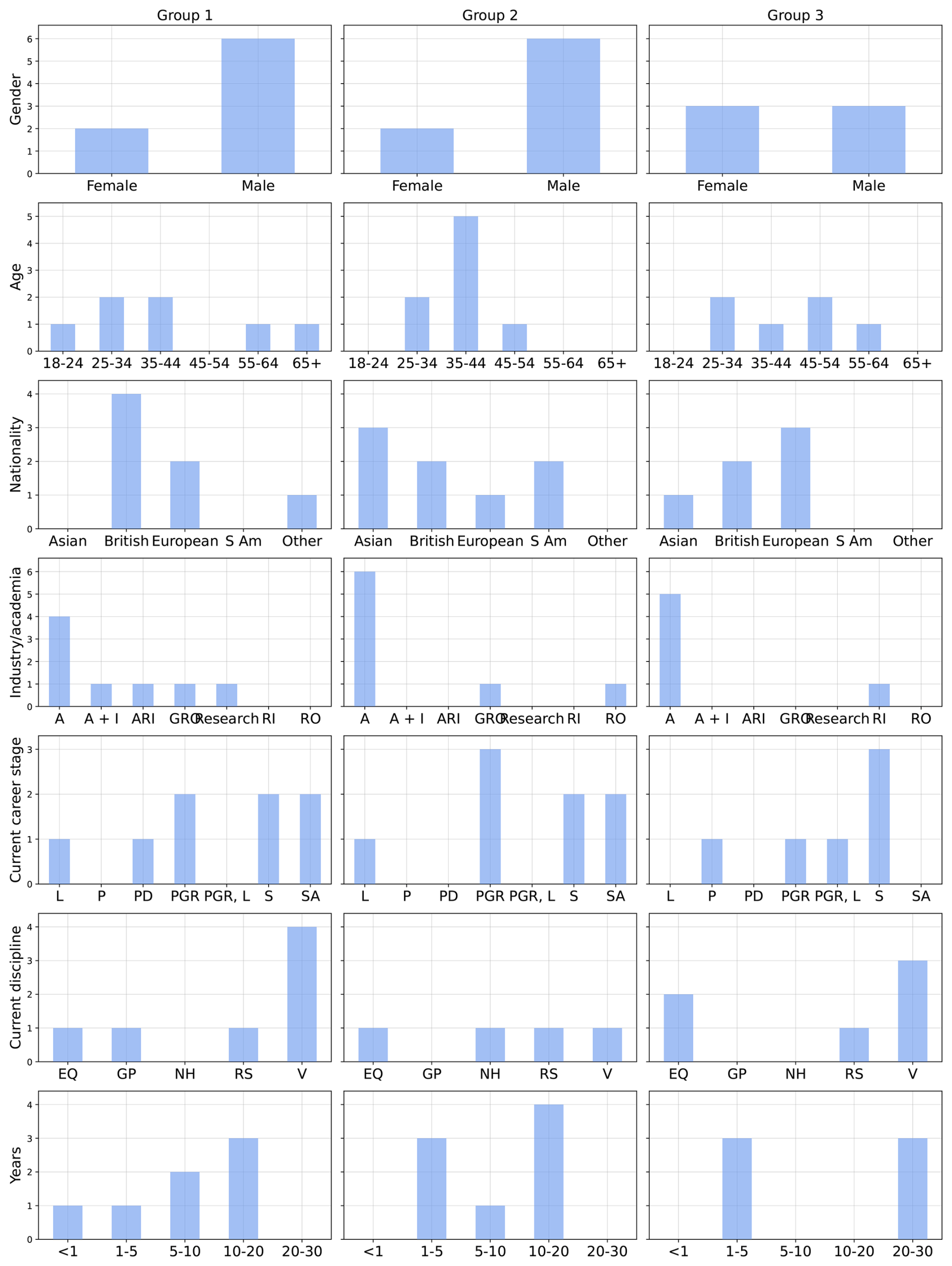
Figure B1FGD participant demographics. Focus Group Discussion (FGD) participant demographics. Each column represents focus group of participants and each row describes a self-identified participant characteristic of participants in that group. The total of each bar is the total number of participants in that group who self-identified as that characteristic in the “Participant Information Form”. For the “Nationality” row British includes English, Scottish and Welsh. European includes non-British European countries; “S Am” = South American. The “Industry/academia” row denotes whether a participant worked in industry (“I”; also commercial company); academia (“A”); in both academic and industrial settings (“A + I”); whether they worked in a Government Research Organisation (“GRO”) or another self-defined institution (“RI” = Research Institute; “ARI” = Applied Research Institute; “RO” = Research Organisation). Row “Current career stage” indicates the career level of the participant at the time of the FDGs (“L” = Lecturer; “P” = Professor; “PD” = postdoctoral researcher; “PGR” = postgraduate researcher; “S” = Scientist; “SA” = Senior Academic). Row “Current discipline” indicates the primary research discipline the participant researched at the time of FGDs (“EQ” = Earthquakes/seismology; “GP” = Geophysics; “NH” = Natural Hazards; “RS” = Remote Sensing, “V” = Volcanology). The final row “Years” denotes the number of years the participant has used satellite data in their career.
Including participants in all three groups, there were 15 self-identified male and seven female participants; eight British, six non-UK European, and six non-European participants; 15 from academia, one working in both academia and industry, and all others working in a government or other research institute, agency, or organisation. There were seven postgraduate researchers (one of which also lectures), four professors, two lecturers, one postdoctoral fellow, and six who identified as scientists including remote sensing scientists. One participant had worked with satellite data for less than a year, ten for 1–5 years, seven 10–20 years, and three 20–30 years. The breakdown of participants into the three focus groups is illustrated in Fig. B1.
B2 Data collection
B2.1 Focus group discussions
FGD participants were provided with a brief verbal introduction to the research and how the FGD session would run, including an emphasis on participation being optional followed by time to ask questions. Each group took their seat with their first moderator and each participant introduced themselves to their group. The moderators then began the discussion by posing the first question for their topic. FGD audio was recorded throughout by the moderators using a dictaphone or Microsoft Teams. Each group of participants rotated between moderators every 10 min. Given unforeseen time constraints, moderators did not always have time to ask all questions depending on the depth of discussion of each topic within each group.
FGD moderators were staff or students at the University of Leeds in the authors' wider research group who were selected based on previous experience running focus or research group discussions. A week in advance of the FGDs, moderators were provided with guidance to the FGD aims, how the FGDs fitted into the wider study aims, guidance on moderator conduct, and a “Topic Guide”. This week allowed time to digest and ask questions to the study leaders. The “Topic Guide” set out the three key topics to be explored during FGDs, providing three questions per topic for moderators to ask. Moderators were guided to intervene as little as possible, allowing discussion to be stimulated from the “Topic Guide”. Intervention was encouraged only to clarify participant meaning and stimulate discussion.
This study focused on capturing the opinions of UK-based remote sensing research scientists, 2023–2024, who study geohazards. These scientists were mainly part of COMET and related personal networks. This focus on COMET lead to a strong focus in our collected data on InSAR and other SAR data products and their use, rather than on other satellite data products such as optical, altimeter, or thermal data. Further work could aim to better sample researchers who use these other datasets to study geohazards. Additionally, similar studies could be conducted among geohazard remote sensing communities in other countries to see how ethical opinions vary.
We acknowledge that our findings represent a small snapshot in time of geohazard remote sensing perceptions and opinions from the perspective of researchers trained as data scientists, geophysicists, or remote sensing scientists working in a Global North research setting. As a demonstration of how communication strategies changed for these researchers during the study period and up to publication of this manuscript, the social network “Twitter” was bought and rebranded to “X” in July 2023. This change may have significantly affected researchers who relied on Twitter as a communication strategy. COMET themselves used Twitter (and currently rely on X) alongside open-access data portals to disseminate ground deformation data (Watson et al., 2023). Twitter before July 2023 was also used as a platform for geoscience discussion and collation of geohazard events by the wider community (Lacassin et al., 2020; Ruan et al., 2022). Due to the timing of Twitter's transformation towards the end of most of our data collection (after eleven interviews and FGDs), we could not fully explore its impact on geohazard remote sensing communication and result dissemination. Future work should aim to explore the impact of this and other changes in social media platforms on geohazard research dissemination strategies and success.
Due to the potential sensitivity of interview and Focus Group Discussion (FGD) material, as well as the possibility of interview and FGD material being used to identify participants, we choose not to openly release resulting manuscripts or recordings with our manuscript. Audio data are stored on secure University of Leeds compute storage using pseudonymisation to protect participants' personal data. The pseudonymisation master list is password protected, with the password known only by the lead author.
JAP and KD conceptualised the study aims and methodology. JAP planned interview and FGD questions, and their formats. JAP performed interviews and oversaw moderators during FGDs. JAP performed data analysis and wrote the article original draft. KD supervised and reviewed all stages of study design, execution, analysis, and writing.
The contact author has declared that neither of the authors has any competing interests.
Participation in all interviews and Focus Group Discussions in this study was voluntary. Participants were informed before their participation that they were able to withdraw up until dissemination of study results. Data were pseudonymised upon collection. Participants completed and returned to the study coordinators a study-specific Consent Form. The University of Leeds' Business, Environment, Social Sciences joint Faculties Research Ethics Committee granted ethical review for this study.
Publisher's note: Copernicus Publications remains neutral with regard to jurisdictional claims made in the text, published maps, institutional affiliations, or any other geographical representation in this paper. The authors bear the ultimate responsibility for providing appropriate place names. Views expressed in the text are those of the authors and do not necessarily reflect the views of the publisher.
The authors wish to thank Ruth Sylvester for her support in the ethical review process. We additionally acknowledge FGD moderators Qi Ou, C. Scott Watson, and Eilish O'Grady. Finally, we thank COMET managers for allowing us to run a session at their annual meeting, and COMET members and all other study participants for their honest insight into the world of geohazard satellite remote sensing in the UK.
This research has been supported by the Natural Environment Research Council (grant no. NE/T00939X/1).
This paper was edited by Solmaz Mohadjer and reviewed by Sam Wimpenny and Maria Vittoria Gargiulo.
Alexander, D. E.: The L'Aquila Earthquake of 6 April 2009 and Italian Government Policy on Disaster Response, J. Natural Resour. Policy Res., 2, 325–342, https://doi.org/10.1080/19390459.2010.511450, 2010. a
Andrabi, S.: Decolonising knowledge production in disaster management: a feminist perspective, Disast. Prevent. Manage., 31, 202–214, https://doi.org/10.1108/DPM-04-2021-0154, 2022. a, b
Argyropoulos, V., Polikreti, K., Simon, S., and Charalambous, D.: Ethical issues in research and publication of illicit cultural property, J. Cult. Herit., 12, 214–219, https://doi.org/10.1016/j.culher.2010.09.007, 2011. a
Audacity Developer Team: Audacity, GitHub [data set], https://github.com/audacity (last access: 17 April 2025), 2023. a
Babinski, G.: GIS&T for equity and social justice, https://doi.org/10.22224/gistbok/2017.2.2, 2021. a
Barnes, B. R.: Decolonising research methodologies: opportunity and caution, S. Afr. J. Psychol., 48, 379–387, https://doi.org/10.1177/0081246318798294, 2018. a
Barton, T. M., Beaven, S. J., Cradock-Henry, N. A., and Wilson, T. M.: Knowledge sharing in interdisciplinary disaster risk management initiatives: cocreation insights and experience from New Zealand, Ecol. Soc., 25, 1–18, https://doi.org/10.5751/ES-11928-250425, 2020. a
Bennett, M. M.: Is a pixel worth 1000 words? Critical remote sensing and China's Belt and Road Initiative, Polit. Geogr., 78, 102127, https://doi.org/10.1016/j.polgeo.2019.102127, 2020. a
Bennett, M. M., Chen, J. K., Alvarez León, L. F., and Gleason, C. J.: The politics of pixels: A review and agenda for critical remote sensing, Prog. Hum. Geogr., 46, 729–752, https://doi.org/10.1177/03091325221074691, 2022. a, b, c
Bennett, M. M., Gleason, C. J., Tellman, B., Alvarez Leon, L. F., Friedrich, H. K., Ovienmhada, U., and Mathews, A. J.: Bringing satellites down to Earth: Six steps to more ethical remote sensing, Global Environ. Change Adv., 2, 100003, https://doi.org/10.1016/j.gecadv.2023.100003, 2024. a, b, c, d, e, f
Bobrowsky, P., Cronin, V. S., Di Capua, G., Kieffer, S. W., and Peppoloni, S.: The Emerging Field of Geoethics, in: Scientific Integrity and Ethics in the Geosciences, AGU – American Geophysical Union, 175–212, ISBN 978-1-119-06782-5, https://doi.org/10.1002/9781119067825.ch11, 2017. a, b, c, d, e
Bond, T.: Ethical imperialism or ethical mindfulness? Rethinking ethical review for social sciences, Res. Ethics, 8, https://doi.org/10.1177/1747016112445419, 2012. a, b, c, d, e, f, g
Bryant, A.: Re-Grounding Grounded Theory, J. Inform. Technol. Theory Appl., 4, 7, 2002. a
Bryant, A.: A Constructive/ist Response to Glaser. About Barney G. Glaser: Constructivist Grounded Theory? Published in FQS 3(3), Forum Qualitative Sozialforschung/Forum: Qualitative Social Research, 4, https://doi.org/10.17169/fqs-4.1.757, 2003. a
Bürgmann, R., Ayhan, M. E., Fielding, E. J., Wright, T. J.,McClusky, S., Aktug, B., Demir, C., Lenk, O., and Türkezer, A.: Deformation during the 12 November 1999 Düzce, Turkey, Earthquake, from GPS and InSAR Data, Bull. Seismol. Soc. Am., 92, 161–171, https://doi.org/10.1785/0120000834, 2002. a
Charmaz, K.: Grounded theory: objectivist and constructivist methods, in: Handbook of Qualitative Research, 2nd Edn., SAGE Publications, London, 509–535, ISBN 0-7619-1512-5, 2000. a
Charmaz, K.: Constructing Grounded Theory: A Practical Guide through Qualitative Analysis, SAGE, ISBN 978-1-4462-0040-7, 2006. a
Charmaz, K.: Grounded Theory, in: Qualitative psychology: A practical guide to research methods, in: vol. 3, SAGE Publications, 53–84, ISBN 9781446298459, 2015. a, b, c, d, e, f, g, h
Cloud, J.: Imaging the World in a Barrel: CORONA and the Clandestine Convergence of the Earth Sciences, Social Stud. Sci., 31, 231–251, https://doi.org/10.1177/0306312701031002005, 2001. a
COMET: COMET Annual Report 2023/2024, Tech. rep., University of Leeds, https://comet.nerc.ac.uk/wp-content/uploads/2025/03/COMET-Annual-Report-2023_2024.pdf (last access: 1 July 2026), 2024. a
Cope, M.: International Encyclopedia of Human Geography, in: Transcripts (coding and analysis), vol. 3, 350–354, University of Leeds, https://leeds.primo.exlibrisgroup.com (last access: 17 April 2025), 2009. a
Costantini, M., Minati, F., Trillo, F., Ferretti, A., Novali, F., Passera, E., Dehls, J., Larsen, Y., Marinkovic, P., Eineder, M., Brcic, R., Siegmund, R., Kotzerke, P., Probeck, M., Kenyeres, A., Proietti, S., Solari, L., and Andersen, H. S.: European Ground Motion Service (EGMS), in: 2021 IEEE International Geoscience and Remote Sensing Symposium IGARSS, 3293–3296, https://doi.org/10.1109/IGARSS47720.2021.9553562, 2021. a
Couldry, N. and Mejias, U. A.: Data Colonialism: Rethinking Big Data's Relation to the Contemporary Subject, Televis. New Media, 20, 336–349, https://doi.org/10.1177/1527476418796632, 2019. a
Cutcliffe, J. R.: Methodological issues in grounded theory, J. Adv. Nurs., 31, 1476–1484, https://doi.org/10.1046/j.1365-2648.2000.01430.x, 2001. a
Dey, I.: Grounding Grounded Theory: Guidelines for Qualitative Inquiry, Academic Press,, San Diego, ISBN 978-0-12-214640-4, 1999. a, b
Di Capua, G.: Geoethical implications in the L'Aquila case: scientific knowledge and communication, in: EGU General Assembly Conference Abstracts, EGU2013–8186, Vienna, Austria, 2013. a, b, c
Di Capua, G. and Peppoloni, S.: Defining Geoethics, International Association for Promoting Geoethics, https://www.geoethics.org/definition (last access: 15 July 2026), 2019. a
Di Capua, G. and Peppoloni, S.: The International Geoethics Research Infrastructure, J. Geoeth. Social Geosci., 2, 1–20, https://doi.org/10.4401/jgsg-57, 2025. a, b, c
Duchossois, G. and Honvault, C.: The First ESA Remote Sensing Satellite (ERS) – The Programme and the System, in: OCEANS 81, 1014–1018, https://doi.org/10.1109/OCEANS.1981.1151522, 1981. a
Dumery, L., Codou, G., Duverger, T., Melac, L., Vesco, C., and Chassin, O.: Towards a more reactive Earth observation Pleiades system!, in: 2018 SpaceOps Conference, American Institute of Aeronautics and Astronautics, Marseille, France, ISBN 978-1-62410-562-3, https://doi.org/10.2514/6.2018-2644, 2018. a, b
Elliott, J. R., Fang, J., Lazecký, M., Maghsoudi, Y., Ou, Q., Payne, J. A., Rollins, C., Wang, D., Hooper, A., and Wright, T. J.: Deformation, strains and velocities for the Alpine Himalayan Belt from trans-continental Sentinel-1 InSAR & GNSS, Remote Sens. Environ., 338, 115320, https://doi.org/10.1016/j.rse.2026.115320, 2026. a
Elwood, S.: Making Space for Integrative Research and Teaching, Environ. Plan. A, 39, 2291–2296, https://doi.org/10.1068/a40145, 2007. a
Elwood, S. and Wilson, M.: Critical GIS pedagogies beyond `Week 10: Ethics', Int. J. Geogr. Inf. Sci., 31, 2098–2116, https://doi.org/10.1080/13658816.2017.1334892, 2017. a
Fakhri, F. and Gkanatsios, I.: Integration of Sentinel-1 and Sentinel-2 data for change detection: A case study in a war conflict area of Mosul city, Remote Sens. Appl.-Soc. Environ., 22, 100505, https://doi.org/10.1016/j.rsase.2021.100505, 2021. a
Fathallah, J.: Open Access Monographs: Myths, Truths and Implications in the Wake of UKRI Open Access Policy, LIBER Quart., 32, https://doi.org/10.53377/lq.11068, 2022. a
Fisher, M., Fradley, M., Flohr, P., Rouhani, B., and Simi, F.: Ethical considerations for remote sensing and open data in relation to the endangered archaeology in the Middle East and North Africa project, Archaeol. Prospect., 28, 279–292, https://doi.org/10.1002/arp.1816, 2021. a, b, c
Fransman, J., Hall, B., Hayman, R., Narayanan, P., Newman, K., and Tandon, R.: Beyond partnerships: embracing complexity to understand and improve research collaboration for global development, Canadian Journal of Development Studies/Revue canadienne d'études du développement, 42, 326–346, https://doi.org/10.1080/02255189.2021.1872507, 2021. a
Fujii, Y. and Satake, K.: Tsunami Source of the 2004 Sumatra–Andaman Earthquake Inferred from Tide Gauge and Satellite Data, Bull. Seismol. Soc. Am., 97, S192–S207, https://doi.org/10.1785/0120050613, 2007. a
Funnell, S. C. and Rogers, P. J.: Purposeful Program Theory: Effective Use of Theories of Change and Logic Models, John Wiley & Sons, ISBN 978-0-470-47857-8, 2011. a
Gaillard, J. C., Alexander, B., Becker, B., Blanchard, K., Bosher, L., Briones, F., Cadag, J. R., Chmutina, K., Coetzee, C., Forino, G., Gomez, C., Jigyasu, R., Kelman, I., Le De, L., Marchezini, V., Mercer, J., Molina, F. G., Raju, E., Sagala, S., Saito, Y., Towers, B., van Niekerk, D., von Meding, J., and Ziqiang, H.: Power, Prestige & Forgotten Values: A Disaster Studies Manifesto, Radixonline.org, https://www.radixonline.org/manifesto-accord (last access: 17 April 2025), 2019. a, b, c, d, e
Gelinas, L., Pierce, R., Winkler, S., Cohen, I. G., Lynch, H. F., and Bierer, B. E.: Using Social Media as a Research Recruitment Tool: Ethical Issues and Recommendations, Am. J. Bioeth., 17, 3–14, https://doi.org/10.1080/15265161.2016.1276644, 2017. a
Ghorbanian, A., Kakooei, M., Amani, M., Mahdavi, S., Mohammadzadeh, A., and Hasanlou, M.: Improved land cover map of Iran using Sentinel imagery within Google Earth Engine and a novel automatic workflow for land cover classification using migrated training samples, ISPRS J. Photogram. Remote Sens., 167, 276–288, https://doi.org/10.1016/j.isprsjprs.2020.07.013, 2020. a
Glaser, B. and Strauss, A. L.: The Discovery of Grounded Theory: Strategies for Qualitative Research, Sociology Press, Aldine, Chicago, ISBN 978-0202300283, 1967. a
Glasgow, L., Adams, E., Joshi, S., Curry, L., Schmitt, C. L., Rogers, T., Willett, J., and Van Hersh, D.: Using a Theory of Change to Guide Grant Monitoring and Grantmaking, J. Publ. Health Manage. Pract., 23, 126, https://doi.org/10.1097/PHH.0000000000000421, 2017. a
Gomez, C. and Hart, D. E.: Disaster gold rushes, sophisms and academic neocolonialism: comments on `Earthquake disasters and resilience in the global North', Geogr. J., 179, 272–277, https://doi.org/10.1111/geoj.12028, 2013. a, b, c, d
Goossens, R., Schmidt, M., Altmaier, A., Benoit, F., and Menz, G.: Extraction of Digital Elevation Models and ortho-images from CORONA KH4B data, in: Proceedings of ISPRS workshop: High resolution mapping from space 2001, Hannover, Germany, 69–76, http://hdl.handle.net/1854/LU-139621 (last access: 17 April 2025), 2001. a
Goward, S., Arvidson, T., Williams, D., Faundeen, J., Irons, J., and Franks, S.: Historical Record of Landsat Global Coverage, Photogram. Eng. Remote Sens., 72, 1155–1169, https://doi.org/10.14358/PERS.72.10.1155, 2006. a
Grinsted, L., Murgatroyd, C., and Burkett, J.: Exploring attitudes to decolonising the science curriculum – A UK Higher Education case study, PLOS ONE, 19, e0312586, https://doi.org/10.1371/journal.pone.0312586, 2024. a
Gupta, S.: Ethical Issues in Designing Internet-Based Research: Recommendations for Good Practice, J. Res. Pract., 13, EJ1174008, 2017. a
Haggerty, K. D.: Ethics Creep: Governing Social Science Research in the Name of Ethics, Qual. Sociol., 27, 391–414, https://doi.org/10.1023/B:QUAS.0000049239.15922.a3, 2004. a, b, c, d
Hall, O., Ohlsson, M., and Rögnvaldsson, T.: A review of explainable AI in the satellite data, deep machine learning, and human poverty domain, Patterns, 3, https://doi.org/10.1016/j.patter.2022.100600, 2022. a
Hák, T., Janoušková, S., and Moldan, B.: Sustainable Development Goals: A need for relevant indicators, Ecol. Indic., 60, 565–573, https://doi.org/10.1016/j.ecolind.2015.08.003, 2016. a, b
Haraway, D.: Situated Knowledges: The Science Question in Feminism and the Privilege of Partial Perspective, Femin. Stud., 14, 575–599, https://doi.org/10.2307/3178066, 1988. a, b
Head, G.: Ethics in educational research: Review boards, ethical issues and researcher development, Eur. Educ. Res. J., 19, 72–83, https://doi.org/10.1177/1474904118796315, 2020. a, b
Hjartardóttir, A. R., Dürig, T., Parks, M., Drouin, V., Eyjólfsson, V., Reynolds, H., Einarsson, P., Jensen, E. H., Óskarsson, B. V., Belart, J. M. C., Ruch, J., Gies, N. B., and Pedersen, G. B. M.: Pre-existing fractures and eruptive vent openings during the 2021 Fagradalsfjall eruption, Iceland, Bull. Volcanol., 85, https://doi.org/10.1007/s00445-023-01670-z, 2023. a
Inuwa-Dutse, I.: FATE in AI: Towards Algorithmic Inclusivity and Accessibility, in: Proceedings of the 3rd ACM Conference on Equity and Access in Algorithms, Mechanisms, and Optimization, EAAMO '23, Association for Computing Machinery, New York, NY, USA, 1–14, ISBN 979-8-4007-0381-2, https://doi.org/10.1145/3617694.3623233, 2023. a
Jutz, S. and Milagro-Pérez, M. P.: Copernicus: the European Earth Observation programme, Revista de Teledetección, 56, V–XI, https://doi.org/10.4995/raet.2020.14346, 2020. a
Kagan, Y. Y. and Jackson, D. D.: Tohoku Earthquake: A Surprise?, Bull. Seismol Soc. Am., 103, 1181–1194, https://doi.org/10.1785/0120120110, 2013. a
Kennedy, I. and Grubb, A.: Medical Law, in: 3rd Edn., Butterworths, London, ISBN 978-0406903259, 2000. a
Khan, R.: Disrupting the Empire and Forging IR: The Role of India's Early Think Tanks in the Decolonisation Process, 1936–1950s, Int. Hist. Rev., 44, 836–855, https://doi.org/10.1080/07075332.2021.1947866, 2022. a, b, c, d, e, f
Kochupillai, M., Kahl, M., Schmitt, M., Taubenböck, H., and Zhu, X. X.: Earth Observation and Artificial Intelligence: Understanding emerging ethical issues and opportunities, IEEE Geosci. Remote Sens. Mag., 10, 90–124, https://doi.org/10.1109/MGRS.2022.3208357, 2022. a
Kurekin, A. A., Loveday, B. R., Clements, O., Quartly, G. D., Miller, P. I., Wiafe, G., and Adu Agyekum, K.: Operational Monitoring of Illegal Fishing in Ghana through Exploitation of Satellite Earth Observation and AIS Data, Remote Sens., 11, 293, https://doi.org/10.3390/rs11030293, 2019. a
Kwet, M.: Digital colonialism: US empire and the new imperialism in the Global South, Race Class, 60, 3–26, https://doi.org/10.1177/0306396818823172, 2019. a
Lacassin, R., Devès, M., Hicks, S. P., Ampuero, J.-P., Bossu, R., Bruhat, L., Daryono, Wibisono, D. F., Fallou, L., Fielding, E. J., Gabriel, A.-A., Gurney, J., Krippner, J., Lomax, A., Sudibyo, Muh. M., Pamumpuni, A., Patton, J. R., Robinson, H., Tingay, M., and Valkaniotis, S.: Rapid collaborative knowledge building via Twitter after significant geohazard events, Geosci. Commun., 3, 129–146, https://doi.org/10.5194/gc-3-129-2020, 2020. a
Lazecký, M., Spaans, K., González, P. J., Maghsoudi, Y., Morishita, Y., Albino, F., Elliott, J., Greenall, N., Hatton, E., Hooper, A., Juncu, D., McDougall, A., Walters, R. J., Watson, C. S., Weiss, J. R., and Wright, T. J.: LiCSAR: An Automatic InSAR Tool for Measuring and Monitoring Tectonic and Volcanic Activity, Remote Sens., 12, 2430, https://doi.org/10.3390/rs12152430, 2020. a
Li, S., Xu, W., and Li, Z.: Review of the SBAS InSAR Time-series algorithms, applications, and challenges, Geod. Geodynam., 13, 114–126, https://doi.org/10.1016/j.geog.2021.09.007, 2022. a
Li, Z., Meier, M.-A., Hauksson, E., Zhan, Z., and Andrews, J.: Machine Learning Seismic Wave Discrimination: Application to Earthquake Early Warning, Geophys. Res. Lett., 45, 4773–4779, https://doi.org/10.1029/2018GL077870, 2018. a
Louet, J. and Bruzzi, S.: ENVISAT mission and system, in: IEEE 1999 International Geoscience and Remote Sensing Symposium, IGARSS'99 (Cat. No. 99CH36293), vol. 3, 1680–1682, https://doi.org/10.1109/IGARSS.1999.772059, 1999. a
Lowenstern, J. B., Wallace, K., Barsotti, S., Sandri, L., Stovall, W., Bernard, B., Privitera, E., Komorowski, J.-C., Fournier, N., Balagizi, C., and Garaebiti, E.: Guidelines for volcano-observatory operations during crises: recommendations from the 2019 volcano observatory best practices meeting, J. Appl. Volcanol., 11, 3, https://doi.org/10.1186/s13617-021-00112-9, 2022. a
Loyola-Hernández, L. and Gosal, A.: Impact of decolonising initiatives and practices in the Faculty of Environment, University of Leeds, https://eprints.whiterose.ac.uk/id/eprint/191449/ (last access: 17 April 2025), 2022. a
Massonnet, D. and Feigl, K. L.: Radar interferometry and its application to changes in the Earth's surface, Rev. Geophys., 36, 441–500, https://doi.org/10.1029/97RG03139, 1998. a
McWhinnie, S.: The Demographics and Research Interests of the UK Astronomy and Geophysics Communities 2023, Tech. rep., Royal Astronomical Society, London, https://ras.ac.uk/sites/default/files/2025-02/Demographics and Research Interests of the UK Astronomy and Geophysics 2023 Final v1_0.pdf (last access: 17 April 2025), 2023. a
Memarian, B. and Doleck, T.: Fairness, Accountability, Transparency, and Ethics (FATE) in Artificial Intelligence (AI) and higher education: A systematic review, Comput. Educ.-Artif. Intel., 5, 100152, https://doi.org/10.1016/j.caeai.2023.100152, 2023. a, b, c, d, e, f, g, h
Mertz, M. and Strech, D.: Systematic and transparent inclusion of ethical issues and recommendations in clinical practice guidelines: a six-step approach, Implement. Sci., 9, 184, https://doi.org/10.1186/s13012-014-0184-y, 2014. a
Meyer, F. J., Rosen, P. A., Flores, A., Anderson, E. R., and Cherrington, E. A.: Making Sar Accessible: Education & Training in Preparation for Nisar, in: 2021 IEEE International Geoscience and Remote Sensing Symposium IGARSS, 6–9, https://doi.org/10.1109/IGARSS47720.2021.9554822, 2021. a
Meyer, F. J., Rosen, P. A., Fattahi, H., Hogenson, K., Albright, R. W., Wagner, C., Short, G., Kristenson, K., Kennedy, J. H., and Kristenson, H.: Making NISAR Data Accessible to the Community, in: EUSAR 2024; 15th European Conference on Synthetic Aperture Radar, 1107–1111, https://ui.adsabs.harvard.edu/link_gateway/2024igar.conf.1517M/doi:10.1109/IGARSS53475.2024.10642848 (last access: 17 April 2025), 2024. a, b
Micheli, M., Gevaert, C. M., Carman, M., Craglia, M., Daemen, E., Ibrahim, R. E., Kotsev, A., Mohamed-Ghouse, Z., Schade, S., Schneider, I., Shanley, L. A., Tartaro, A., and Vespe, M.: AI ethics and data governance in the geospatial domain of Digital Earth, Big Data Soc., 9, 20539517221138767, https://doi.org/10.1177/20539517221138767, 2022. a
Miller, T., Birch, M., Mauthner, M., Jessop, J., Miller, T., and Bell, L.: Consenting to What? Issues of Access, Gate-Keeping and Informed Consent, in: Ethics in Qualitative Research, SAGE Publications Ltd, 61–75, ISBN 978-1-4739-1391-2, https://doi.org/10.4135/9781473913912.n5, 2012. a
Mills, J., Bonner, A., and Francis, K.: The Development of Constructivist Grounded Theory, Int. J. Qual. Meth., 5, 25–35, https://doi.org/10.1177/160940690600500103, 2006. a
Mogk, D. W., Geissman, J. W., and Bruckner, M. Z.: Teaching Geoethics Across the Geoscience Curriculum: Why, When, What, How, and Where?, Scientific Integrity and Ethics in the Geosciences, 231–265, https://doi.org/10.1002/9781119067825, 2017. a, b, c
Morishita, Y., Lazecky, M., Wright, T. J., Weiss, J. R., Elliott, J. R., and Hooper, A.: LiCSBAS: An Open-Source InSAR Time Series Analysis Package Integrated with the LiCSAR Automated Sentinel-1 InSAR Processor, Remote Sens., 12, 424, https://doi.org/10.3390/rs12030424, 2020. a
Naddaf, M.: Turkey–Syria earthquake: what scientists know, Nature, 614, 398–399, https://doi.org/10.1038/d41586-023-00364-y, 2023. a, b
Nelson, T. A., Goodchild, M. F., and Wright, D. J.: Accelerating ethics, empathy, and equity in geographic information science|PNAS, Comput. Sci., 119, https://doi.org/10.1073/pnas.2119967119, 2022. a
Niwattanakul, S., Singthongchai, J., Naenudorn, E., and Wanapu, S.: Using of Jaccard Coefficient for Keywords Similarity, Hong Kong, in: Proceedings of the International MultiConference of Engineers and Computer Scientists 2013, Vol. I, ISBN 978-988-19251-8-3, https://www.iaeng.org/publication/IMECS2013/IMECS2013_pp380-384.pdf (last access: 1 July 2026), 2013. a
Osmanoğlu, B., Sunar, F., Wdowinski, S., and Cabral-Cano, E.: Time series analysis of InSAR data: Methods and trends, ISPRS J. Photogram. Remote Sens., 115, 90–102, https://doi.org/10.1016/j.isprsjprs.2015.10.003, 2016. a
Page, T.: The Practice of Making Ethics: Methodological Entanglements and Speculative Governance, Qual. Inquiry, 32, 376–385, https://doi.org/10.1177/10778004251355911, 2026. a
Peppoloni, S. and Capua, G. D.: Geoethics: Ethical, Social and Cultural Implications in Geosciences, Ann. Geophys., 60, https://doi.org/10.4401/ag-7473, 2017. a
Peppoloni, S. and Di Capua, G.: Geoethics to Start Up a Pedagogical and Political Path towards Future Sustainable Societies, Sustainability, 13, 10024, https://doi.org/10.3390/su131810024, 2021. a, b
Peppoloni, S., Bilham, N., and Di Capua, G.: Contemporary Geoethics Within the Geosciences, in: Exploring Geoethics: Ethical Implications, Societal Contexts, and Professional Obligations of the Geosciences, edited by: Bohle, M., Springer International Publishing, Cham, 25–70, ISBN 978-3-030-12010-8, https://doi.org/10.1007/978-3-030-12010-8_2, 2019. a, b, c, d, e, f, g, h, i, j, k, l, m, n, o, p
Poland, B. D.: Transcription Quality as an Aspect of Rigor in Qualitative Research, Qual. Inquiry, 1, 290–310, https://doi.org/10.1177/107780049500100302, 1995. a
Potin, P., Rosich, B., Grimont, P., Miranda, N., Shurmer, I., O'Connell, A., Torres, R., and Krassenburg, M.: Sentinel-1 Mission Status, in: Proceedings of EUSAR 2016: 11th European Conference on Synthetic Aperture Radar, 1–6, https://ieeexplore.ieee.org/abstract/document/7559246 (last access: 17 April 2025), 2016. a
Queiroz de Almeida, V., Matar, J., Rodriouez-Cassola, M., Moreira, A., Haagmans, R., Bensi, P., and Petrolati, D.: Orbit. Performance and Observation Scenarios for Esa's Earth Explorer Mission Proposal Hydroterra, in: 2021 IEEE International Geoscience and Remote Sensing Symposium IGARSS, 7740–7743, https://doi.org/10.1109/IGARSS47720.2021.9554602, 2021. a
Reinholz, D. L. and Andrews, T. C.: Change theory and theory of change: what's the difference anyway?, Int. J. STEM Educ., 7, 2, https://doi.org/10.1186/s40594-020-0202-3, 2020. a
Rosen, P., Hensley, S., Shaffer, S., Edelstein, W., Kim, Y., Kumar, R., Misra, T., Bhan, R., and Sagi, R.: The NASA-ISRO SAR (NISAR) mission dual-band radar instrument preliminary design, in: 2017 IEEE International Geoscience and Remote Sensing Symposium (IGARSS), 3832–3835, https://doi.org/10.1109/IGARSS.2017.8127836, 2017. a
Ruan, T., Kong, Q., McBride, S. K., Sethjiwala, A., and Lv, Q.: Cross-platform analysis of public responses to the 2019 Ridgecrest earthquake sequence on Twitter and Reddit, Sci. Rep., 12, 1634, https://doi.org/10.1038/s41598-022-05359-9, 2022. a
Salcedo-Sanz, S., Ghamisi, P., Piles, M., Werner, M., Cuadra, L., Moreno-Martínez, A., Izquierdo-Verdiguier, E., Muñoz-Marí, J., Mosavi, A., and Camps-Valls, G.: Machine learning information fusion in Earth observation: A comprehensive review of methods, applications and data sources, Inform. Fusion, 63, 256–272, https://doi.org/10.1016/j.inffus.2020.07.004, 2020. a
Sayer, R. A.: Method in Social Science: A Realist Approach, Routledge, London, ISBN 978-0-415-07607-4, 1992. a
Schrag, Z. M.: The Case against Ethics Review in the Social Sciences, Res. Ethics, 7, 120–131, https://doi.org/10.1177/174701611100700402, 2011. a
Scolobig, A. and Pelling, M.: The co-production of risk from a natural hazards perspective: science and policy interaction for landslide risk management in Italy, Nat. Hazards, 81, 7–25, https://doi.org/10.1007/s11069-015-1702-1, 2016. a
Smith, R. G. and Majumdar, S.: Groundwater Storage Loss Associated With Land Subsidence in Western United States Mapped Using Machine Learning, Water Resour. Res., 56, e2019WR026621, https://doi.org/10.1029/2019WR026621, 2020. a
Solari, L., Crosetto, M., Balasis-Levinsen, J., Bateson, L., Casagli, N., Comerci, V., Guerrieri, L., Frei, M., Mroz, M., Moldestad, D. A., Oyen, A., Costantini, M., Minati, F., Trillo, F., Proietti, S., Ferretti, A., Passera, E., Dehls, J., Larsen, Y., Marinkovic, P., Eineder, M., Brcic, R., Siegmund, R., Kotzerke, P., Kenyeres, A., and Andersen, H. S.: First look at the European Ground Motion Service products, DLR Library, Bonn, Germany, https://elib.dlr.de/186685/ (last access: 17 April 2025), 2022. a, b
Speer, S. A. and Stokoe, E.: Ethics in action: Consent-gaining interactions and implications for research practice, Brit. J. Social Psychol., 53, 54–73, https://doi.org/10.1111/bjso.12009, 2014. a
Stewart, I. S., Sevilla, E., Barragán, K., and Menteşe, E. Y.: Disaster risk communication requires dissemination, dialogue and participation, Nat. Rev. Earth Environ., 4, 805–806, https://doi.org/10.1038/s43017-023-00506-w, 2023. a
Sultana, F.: Reflexivity, Positionality and Participatory Ethics: Negotiating Fieldwork Dilemmas in International Research, Int. J. Crit. Geogr., 6, 374–385, https://doi.org/10.14288/acme.v6i3.786, 2007. a
Thirugnanam, H., Ramesh, M. V., and Rangan, V. P.: Enhancing the reliability of landslide early warning systems by machine learning, Landslides, 17, 2231–2246, https://doi.org/10.1007/s10346-020-01453-z, 2020. a
Thomson, S. B.: Sample Size and Grounded Theory, J. Admin. Govern., 5, 45–52, 2011. a
Tomás, R. and Li, Z.: Earth Observations for Geohazards: Present and Future Challenges, Remote Sens., 9, 194, https://doi.org/10.3390/rs9030194, 2017. a
Torrance, H.: The Research Excellence Framework in the United Kingdom: Processes, Consequences, and Incentives to Engage, Qual. Inquiry, 26, 771–779, https://doi.org/10.1177/1077800419878748, 2020. a, b
Torres, R., Snoeij, P., Geudtner, D., Bibby, D., Davidson, M., Attema, E., Potin, P., Rommen, B., Floury, N., Brown, M., Traver, I. N., Deghaye, P., Duesmann, B., Rosich, B., Miranda, N., Bruno, C., L'Abbate, M., Croci, R., Pietropaolo, A., Huchler, M., and Rostan, F.: GMES Sentinel-1 mission, Remote Sens. Environ., 120, 9–24, https://doi.org/10.1016/j.rse.2011.05.028, 2012. a
Touzi, R., Lopes, A., Bruniquel, J., and Vachon, P.: Coherence estimation for SAR imagery, IEEE T. Geosci. Remote, 37, 135–149, https://doi.org/10.1109/36.739146, 1999. a
Tralli, D. M., Blom, R. G., Zlotnicki, V., Donnellan, A., and Evans, D. L.: Satellite remote sensing of earthquake, volcano, flood, landslide and coastal inundation hazards, ISPRS J. Photogram. Remote Sens., 59, 185–198, https://doi.org/10.1016/j.isprsjprs.2005.02.002, 2005. a
Tran, M. and Kim, D.: Co-production revisited: from knowledge plurality to action for disaster risk reduction, Disast. Prevent. Manage., 33, 250–269, https://doi.org/10.1108/DPM-06-2023-0131, 2023. a
Turbide, S., Marchese, L., Terroux, M., and Bergeron, A.: Synthetic aperture lidar as a future tool for earth observation, in: International Conference on Space Optics – ICSO 2014, vol. 10563, SPIE, 1115–1122, https://doi.org/10.1117/12.2304256, 2017. a
Twigg, J.: Disaster Risk Reduction, no. 9 in Good Practice Review, Humanitarian Policy Group, https://odihpn.org/content/uploads/2011/06/GPR-9-web-string-1.pdf (last access: 17 April 2025), 2015. a
UNESCO: UNESCO Recommendation on Open Science, programme and meeting document SC-PCB-SPP/2021/OS/UROS, UNESCO, Paris, https://unesdoc.unesco.org/ark:/48223/pf0000379949 (last access: 17 April 2025), 2021. a
UNWCDRR: Sendai Framework for Disaster Risk Reduction 2015–2030, https://www.undrr.org/publication/sendai-framework-disaster-risk-reduction-2015-2030 (last access: 17 April 2025), 2015. a, b, c, d, e, f, g, h
Wahyono, S.: Research permit procedures for foreign universities, research and development institutions, companies and individuals, regarding research and development activities in Indonesia, Secretariat Report, The Ministry of Research, Technology and Higher Education, The Republic of Indonesia, https://partnership.itb.ac.id/wp-content/uploads/sites/22/2010/05/Foreign_Research_Permit_Procedure_2015.pdf (last access: 17 April 2025), 2015. a
Walters, R. J., Elliott, J. R., D'Agostino, N., England, P. C., Hunstad, I., Jackson, J. A., Parsons, B., Phillips, R. J., and Roberts, G.: The 2009 L'Aquila earthquake (central Italy): A source mechanism and implications for seismic hazard, Geophys. Res. Lett., 36, https://doi.org/10.1029/2009GL039337, 2009. a
Wasowski, R. J.: Some Ethical Aspects of International Satellite Remote Sensing, Photogram. Eng., 57, 41–48, 1991. a, b
Watson, C. S., Elliott, J. R., Ebmeier, S. K., Biggs, J., Albino, F., Brown, S. K., Burns, H., Hooper, A., Lazecky, M., Maghsoudi, Y., Rigby, R., and Wright, T. J.: Strategies for improving the communication of satellite-derived InSAR data for geohazards through the analysis of Twitter and online data portals, Geosci. Commun., 6, 75–96, https://doi.org/10.5194/gc-6-75-2023, 2023. a, b
Widmer, R. J., Widmer, J. M., and Lerman, A.: International Collaboration: Promises and Challenges, Rambam Maimonides Medical Journal, 6, e0012, https://doi.org/10.5041/RMMJ.10196, 2015. a
Williams, D. L., Goward, S., and Arvidson, T.: Landsat: Yesterday, Today, and Tomorrow, Photogram. Eng. Remote Sens., 72, 1171–1178, https://doi.org/10.14358/PERS.72.10.1171, 2006. a
Woo, G.: Grand Challenges in Geohazards and Georisks, Front. Earth Sci., 5, https://doi.org/10.3389/feart.2017.00019, 2017. a
Woodcock, C. E., Allen, R., Anderson, M., Belward, A., Bindschadler, R., Cohen, W., Gao, F., Goward, S. N., Helder, D., Helmer, E., Nemani, R., Oreopoulos, L., Schott, J., Thenkabail, P. S., Vermote, E. F., Vogelmann, J., Wulder, M. A., and Wynne, R.: Free access to Landsat imagery., Science, 320, 1011, https://doi.org/10.1126/science.320.5879.1011a, 2008. a, b
World Bank: World Bank Open Access Policy for Formal Publications, Policy Paper 67830, World Bank, https://documents.worldbank.org/en/publication/documents-reports/documentdetail/992881468337274796 (last access: 17 April 2025), 2012. a
Wright, T., Fielding, E., and Parsons, B.: Triggered slip: Observations of the 17 August 1999 Izmit (Turkey) Earthquake using radar interferometry, Geophys. Res. Lett., 28, 1079–1082, https://doi.org/10.1029/2000GL011776, 2001. a
Wright, T. J.: Future of Remote Sensing for Geohazards and Resource Monitoring, in: Remote Sensing for Characterization of Geohazards and Natural Resources, edited by: Chaussard, E., Jones, C., Chen, J. A., and Donnellan, A., Springer International Publishing, Cham, 533–551, ISBN 978-3-031-59306-2, https://doi.org/10.1007/978-3-031-59306-2_28, 2024. a, b, c
Yazici, T.: Toward a global standard for ethical AI regulation: addressing gaps in AI-driven biometric and high-resolution satellite imaging in the EU AI Act, Law, Innov. Technol., 17, 366–394, https://doi.org/10.1080/17579961.2025.2470589, 2025. a, b
Zebker, H. A.: User-Friendly InSAR Data Products: Fast and Simple Timeseries Processing, IEEE Geosci. Remote Sens. Lett., 14, 2122–2126, https://doi.org/10.1109/LGRS.2017.2753580, 2017. a, b, c, d
Zoom: Zoom, https://www.zoom.com (last access: 17 April 2025), 2023. a
Zuccaro, G., Leone, M. F., and Martucci, C.: Future research and innovation priorities in the field of natural hazards, disaster risk reduction, disaster risk management and climate change adaptation: a shared vision from the ESPREssO project, Int. J. Disast. Risk Reduct., 51, 101783, https://doi.org/10.1016/j.ijdrr.2020.101783, 2020. a, b, c
- Abstract
- Introduction
- Methodology
- Results
- Discussion
- Future recommendations
- Appendix A: Technical definitions
- Appendix B: Additional methodology
- Appendix C: Additional limitations
- Data availability
- Author contributions
- Competing interests
- Ethical statement
- Disclaimer
- Acknowledgements
- Financial support
- Review statement
- References