the Creative Commons Attribution 4.0 License.
the Creative Commons Attribution 4.0 License.
 | 28 Sep 2021
Teaching with digital geology in the high Arctic: opportunities and challenges
Peter Betlem
Sten-Andreas Grundvåg
Rafael Kenji Horota
Simon John Buckley
Aleksandra Smyrak-Sikora
Malte Michel Jochmann
Thomas Birchall
Julian Janocha
Kei Ogata
Lilith Kuckero
Rakul Maria Johannessen
Isabelle Lecomte
Sara Mollie Cohen
Snorre Olaussen
The Covid-19 pandemic occurred at a time of major revolution in the geosciences – the era of digital geology. Digital outcrop models (DOMs) acquired from consumer drones, processed using user-friendly photogrammetric software and shared with the wider audience through online platforms are a cornerstone of this digital geological revolution. Integration of DOMs with other geoscientific data, such as geological maps, satellite imagery, terrain models, geophysical data and field observations, strengthens their application in both research and education. Teaching geology with digital tools advances students' learning experience by providing access to high-quality outcrops, enhancing visualization of 3D geological structures and improving data integration. Similarly, active use of DOMs to integrate new field observations will facilitate more effective fieldwork and quantitative research. From a student's perspective, georeferenced and scaled DOMs allow for an improved appreciation of scale and of 3D architecture, which is a major threshold concept in geoscientific education.
DOMs allow us to bring geoscientists to the outcrops digitally, which is particularly important in view of the Covid-19 pandemic that restricts travel and thus direct access to outcrops. At the University Centre in Svalbard (UNIS), located at 78∘ N in Longyearbyen in Arctic Norway, DOMs are actively used even in non-pandemic years, as the summer field season is short and not overlapping with the Bachelor “Arctic Geology” course package held from January to June each year. In 2017, we at UNIS developed a new course (AG222 “Integrated Geological Methods: From Outcrop To Geomodel”) to encourage the use of emerging techniques like DOMs and data integration to solve authentic geoscientific challenges. In parallel, we have established the open-access Svalbox geoscientific portal, which forms the backbone of the AG222 course activities and provides easy access to a growing number of DOMs, 360∘ imagery, subsurface data and published geoscientific data from Svalbard. Considering the rapid onset of the Covid-19 pandemic, the Svalbox portal and the pre-Covid work on digital techniques in AG222 allowed us to rapidly adapt and fulfil at least some of the students' learning objectives during the pandemic. In this contribution, we provide an overview of the course development and share experiences from running the AG222 course and the Svalbox platform, both before and during the Covid-19 pandemic.
- Article
(9897 KB) - Full-text XML
-
Supplement
(3040 KB) - BibTeX
- EndNote


From 13 March 2020 until the summer break, all university-level teaching in Norway (including Longyearbyen, where the University Centre in Svalbard (UNIS) is located) was conducted fully digitally due to the Covid-19 pandemic. In Svalbard, this occurred at the worst possible time with respect to the geology bachelor course schedule, as the sun only returns to Longyearbyen on 8 March after a long dark season. March and April represent the major spring field season when snowmobile can be used to access outcrops. In the years leading up to the pandemic, we developed a new methods-focused Bachelor-level course at UNIS, “AG222 Integrated Geological Methods: From Outcrop To Geomodel”, focusing on digital geological techniques in order to extend our field season digitally. This focus on enhancing the value of digital geological methods in education prior to the pandemic was instrumental during the transition to digital teaching of AG222 during the pandemic.
Digital outcrop models (DOMs) have been used for several decades, particularly by the petroleum industry with its need for quantitative data on reservoir architecture (Howell et al., 2014; Marques et al., 2020). Initially, most DOMs were collected by ground- or helicopter-based lidar (LIght Detection And Ranging) scanners (Hodgetts, 2013; Rittersbacher et al., 2013; Buckley et al., 2008), often requiring expensive equipment and significant processing resources, time and specialist skills. The emergence of structure-from-motion (SfM) photogrammetry (e.g., Westoby et al., 2012; Smith et al., 2016), essentially utilizing many overlapping images to construct a DOM, has led to mainstream adoption of DOMs in both teaching (e.g., Senger et al., 2021a; Bond and Cawood, 2021) and research (e.g., Anell et al., 2016; Marques et al., 2020; Rabbel et al., 2018). We consider this a major technology-driven revolution in the geosciences as introduced by Buckley et al. (2019a), similar in significance to the adoption of 3D seismic acquisition that revolutionized our understanding of the subsurface (Cartwright and Huuse, 2005).
To make full use of this digital geoscience revolution, we need to rethink how geology is conducted and taught while maintaining focus on key skill sets required by geologists in today's society. Field-based skills acquired while in the field are central to any geoscientist's education (Mogk and Goodwin, 2012), with digital tools allowing for more efficient field work. In addition, integrating DOMs into a regional geological context using complementary data sets and harvesting these expanding data for quantitative studies, we can take the next step towards “big data geoscience” (e.g., Guo et al., 2014; Bergen et al., 2019). Importantly, we should bring this geoscience revolution to geoscience students at an early stage, by developing skills-oriented courses where tasks are authentic to real-life problems faced by professional geologists.
Actively participating in the digital geoscience revolution has several benefits, including improved accessibility for those that cannot participate in field work (Whitmeyer et al., 2020; Bond and Cawood, 2021), a prolonged field season (Senger and Nordmo, 2020), potential for field work preparation and thus more effective and targeted field work, and reduction in associated environmental and economic costs of field campaigns. It should, however, be stressed that geoscientific field work should not be purely digital. Participation in traditional field work and field excursions is a fundamental aspect of becoming a geoscientist (Mogk and Goodwin, 2012; Kastens et al., 2009), and digital tools should, in our opinion, complement these rather than replace them.
Scientific literature on the application of photogrammetry in geology increases rapidly (Fig. 1) in line with technological advances. More importantly is that DOMs are readily available to the global geoscientific community through a number of open-access repositories such as e-Rock (https://www.e-rock.co.uk/, last access: 7 September 2021; global coverage; Cawood and Bond, 2019), V3Geo (https://v3geo.com/, last access: 7 September 2021), Mosis HUB (https://mosis.vizlab.cc/en/xp/models, last access: 7 September 2021), Virtual Australia (https://ausgeol.org/atlas/, last access: 7 September 2021) or Svalbox (http://www.svalbox.no/, last access: 7 September 2021; Svalbard coverage; Senger et al., 2021a). All of these are useful for teaching purposes and have been heavily used during the Covid-19 pandemic, as they provide examples of a number of lithologies and structural styles that can serve as a backbone to digital teaching exercises.
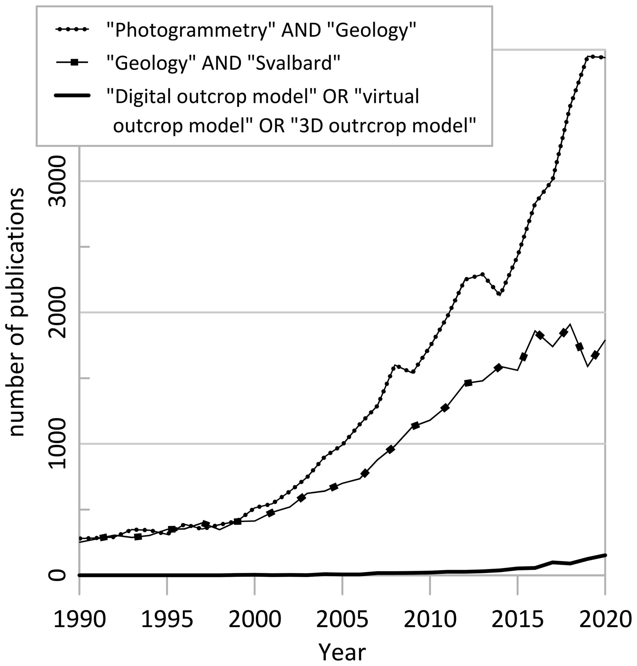
Figure 1The digital geology revolution, as illustrated by the exponential growth in publications from 1990 to 2020 that include “photogrammetry” and “geology”. Similarly, a marked increase is seen in publications including “geology” and “Svalbard”. Data source: Google Scholar.
An important challenge yet to be fully addressed is that while we as a geoscientific community collect more DOMs globally, actively using them for further work is hampered by varying standards, available metadata and access regulations to the actual models. Furthermore, utilizing DOMs to their full potential requires site-specific knowledge of the regional significance of the outcrop, thus often relying on geologists with local expertise and efficiently harvesting the sheer volume of scientific knowledge about a particular area such as Svalbard (Fig. 1).
From a broader perspective, we as educators also need to consider how best to train geoscientists to exploit the digital geoscience revolution to their advantage. The benefits are clear, but the challenges with numerous software (some open source but most proprietary and costly) and using cross-software workflows can also be daunting. In essence, we can ask ourselves the question of how to best teach digital geosciences and whether we can teach it in an active and integrated fashion.
In this contribution, we share our experiences of teaching digital geosciences at UNIS, primarily related to a 15-ECTS bachelor-level course (AG222 Integrated Geological Methods: From Outcrop To Geomodel; ECTS represents European Credit Transfer and Accumulation System; 60 ECTS equals one full-time study year) offered annually since 2018 that actively uses the Svalbox geoscience platform. We outline our experience of both the course development and incremental optimization, including a fully digital field campaign organized in April 2020 during the Covid-19 pandemic. Finally, we identify knowledge gaps that should be addressed to maximize the experience from the Covid-19 pandemic to further improve geoscientific field teaching in the high Arctic.
Svalbox, developed at UNIS since 2017 and introduced by Senger et al. (2021a), is a platform that strives to integrate multi-physical and multi-scale geoscientific data from Svalbard for more effective teaching and research. Svalbox (Fig. 2; Table 1; Video 1 in the Video supplement; Discover Svalbard's Geology with Svalbox available at https://www.youtube.com/watch?v=gJR-qp5XMsw&t=2s, last access: 7 September 2021) comprises both a public web front end sharing most of the openly accessible data (Video 2 in the Video supplement; Svalbox: Introducing the Svalbox.no online map portal available at https://www.youtube.com/watch?v=lTyL9eGmh7s, last access: 7 September 2021), and a UNIS-internal package integrating also classified data in thematic Petrel projects (Video 3 in the Video supplement; Svalbox – what is it and what data do we integrate? available at https://www.youtube.com/watch?v=yLl4R7xTf0U, last access: 7 September 2021).
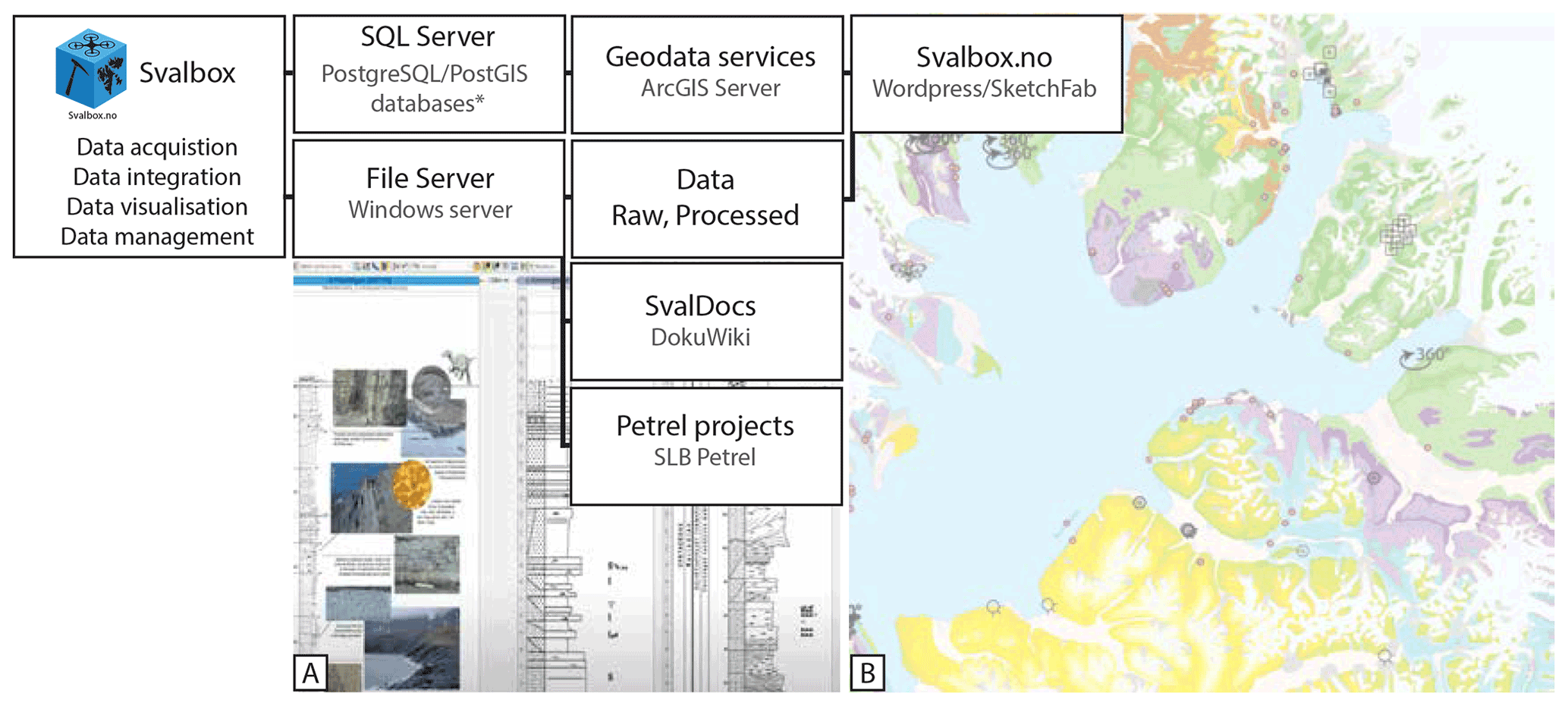
Figure 2Overview of the Svalbox concept and its main elements. (a) Screenshot from the UNIS-internal part of Svalbox, illustrating the correlation of multi-scale sedimentological logs from the Festningen outcrop integrated within the Petrel platform. (b) Screenshot of the open-access part of Svalbox, with geological maps overlain with digital outcrop models, 360∘ imagery and geophysical data sets. Refer to Table 1 for details.

Most of the Svalbox elements can also be used by geoscience courses not run by UNIS, and our ambition is to generate high-quality data sets and educational material to bring Svalbard's exciting geological evolution to classrooms around the world.
Being based in Svalbard, an Arctic archipelago located at 74–81∘ N, the AG222 course had from the onset been designed with the extreme seasonal cycle in mind (Figs. 3, 4; https://www.youtube.com/watch?v=Pjr-4L5zqE8, last access: 7 September 2021). The “Integrated Geological Methods: From Outcrop To Geomodel” (AG222) course was developed at UNIS in 2017 and was run annually from 2018 onwards. In 2018 and 2019, the course was run as planned from January to late May, with up to 20 students admitted each year and a significant field component (Senger et al., 2021a). In 2020, the Covid-19 pandemic led to the second half of the course being run fully digitally with students dispersed throughout Europe. Only 1 d of fieldwork was possible, with the main field campaign to Billefjorden having to be run virtually (Smyrak-Sikora et al., 2020a). In January 2021, the course started as a fully digital course but with students in Longyearbyen. Since no Covid-19 cases were reported from Svalbard until submission of this paper in mid-March 2021, some physical teaching was implemented at UNIS in February 2021, and field excursions were run as planned in March 2021.
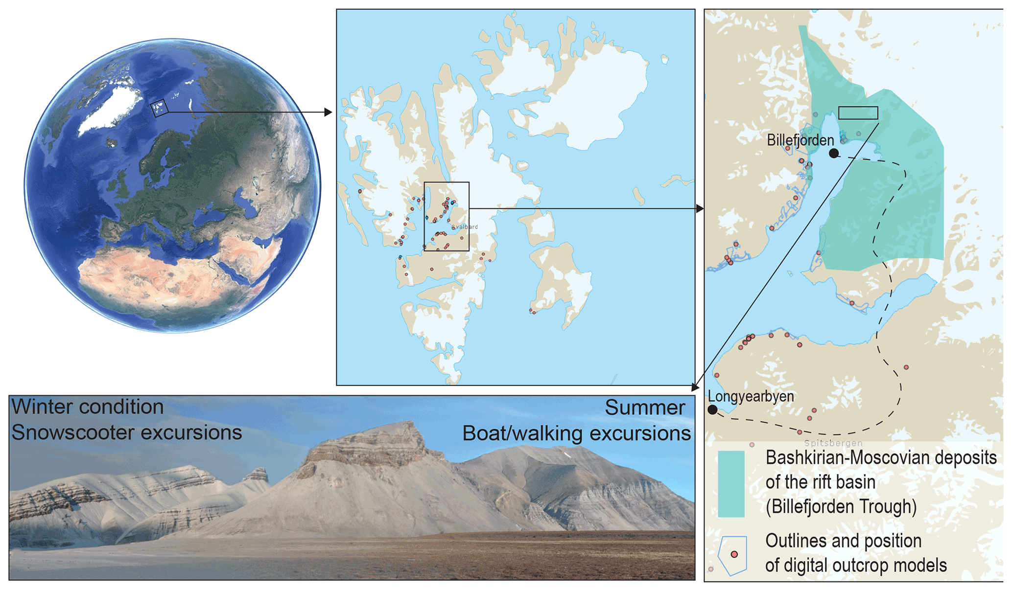
Figure 3Location of Svalbard and the Billefjorden Trough, which is the main field area for the AG222 course. Winter and summer conditions of the same mountain, Løvehovden (see https://toposvalbard.npolar.no/, last access: 7 September 2021, for exact location), are shown for comparison.
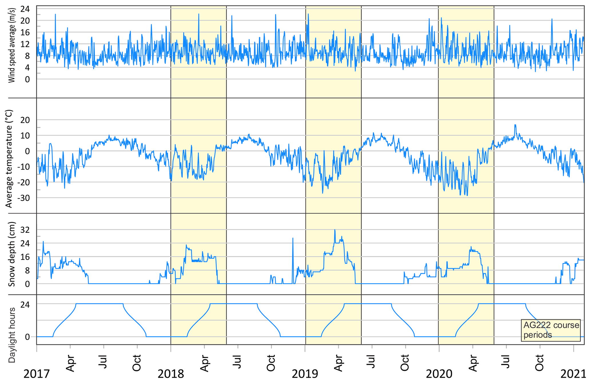
Figure 4Extreme seasonal cycle, as exemplified by the amount of daylight hours, temperature, wind speed and snow depth in Adventdalen near Longyearbyen from 2017 to 2021 (meteorological source: https://klimaservicesenter.no/, last access: 7 September 2021). The AG222 course and field periods are marked – these are characterized with maximum snow cover and lowest temperatures and a rapid shift from no daylight to permanent daylight during the course period.
The overall ambition central to the course development was to provide a new course actively using emerging digital geological techniques applied to geoscience challenges relevant to Svalbard, with the key outcome of developing the problem-solving skills required by geology graduates in their future careers, especially relevant in industry. An important component focuses on the integration of different techniques and data sources, which are important skill sets for professional geologists who also need to act multidisciplinary to solve real-life geological challenges. Furthermore, the course was designed to complement the existing course “The Tectonic and Sedimentary History of Svalbard” (AG209; https://www.unis.no/course/ag-209-the-tectonic-and-sedimentary-history-of-svalbard/, last access: 7 September 2021) running at the same time, attended by the same students and visiting complementary field sites.
Transport to the localities is primarily by snowscooter, which often increases engagement for many students (see Video 4 in the Video supplement; AG222 excursion @ UNIS – February 2020 available at https://www.youtube.com/watch?v=w1XHoM1BlCM, last access: 7 September 2021). The Billefjorden excursion involves a long (ca. 4–5 h) journey to the field area, relying on good visibility as it involves crossing major glaciers exposed to bad weather. Once the field area is reached, a base camp is established in a hotel in Pyramiden, an abandoned coal mining settlement (Fig. 3). From Pyramiden, all localities within the entire Billefjorden Trough are easily accessible within short driving distance (see .gpx files with localities and route in the Supplement). Geological stops are typically up to 1 h long, and summaries of the main learning topics from the visited localities are conducted through student presentations once back in the sheltered base camp.
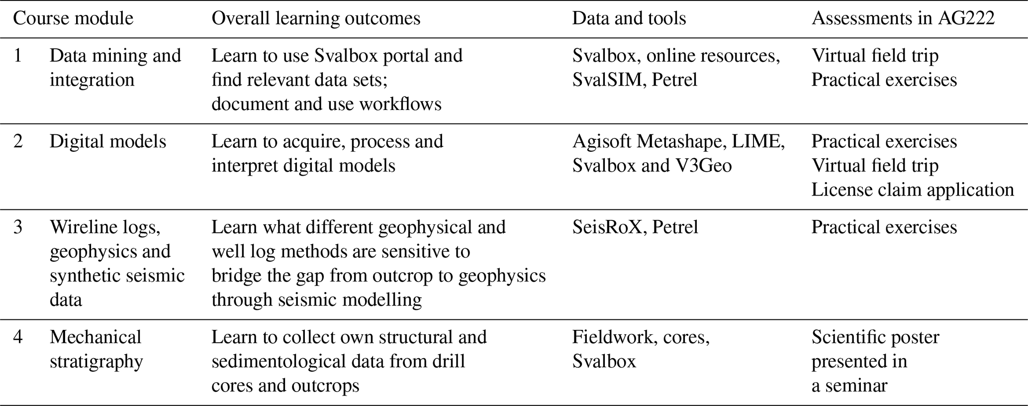
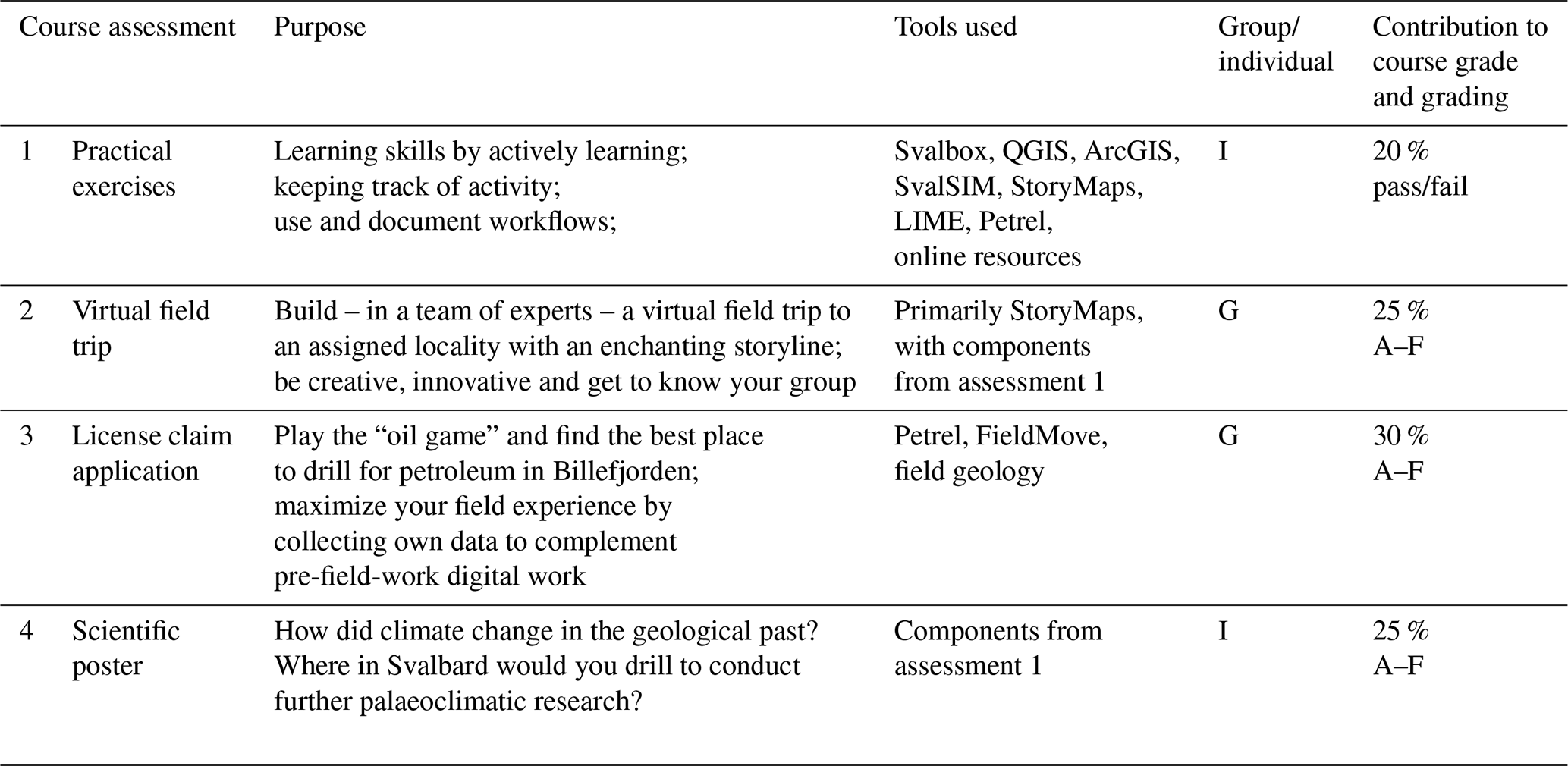
All course modules and assessments in the AG222 course are designed with a strong emphasis on real-world application – i.e., they should represent tasks that professional geologists working in the private or public sector may face in their future careers. There is no final exam, and the course grade reflects tasks conducted throughout the semester, combining both group and individual assessments (Fig. 5). In this section, we present the main course modules and associated assessments. Adequate material is provided in the article and Table A2 to allow for implementation of these elsewhere. Naturally, the exercises are focused on Svalbard's geological record, but the concept can easily be applied in other areas. For educators and students not familiar with Svalbard's geological evolution, Table A2 provides a list of key literature.
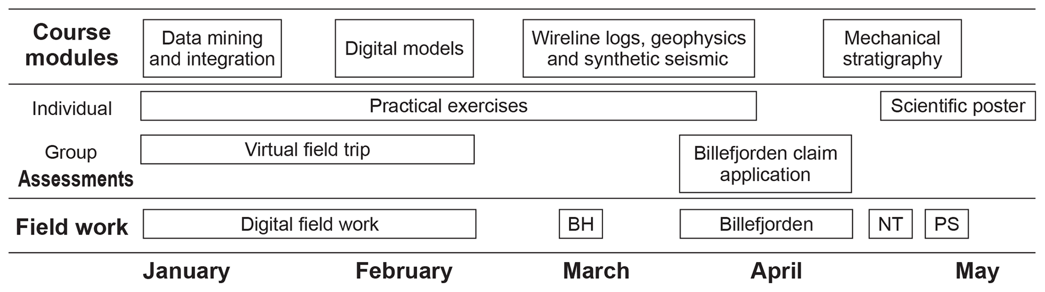
Figure 5Overview of the central elements in the AG222 course; see Tables 2 and 3 for details. The four course modules are organized to build on each other, with skills learnt in the first half of the course highly relevant for the second half. The two main graded group assessments are very intensive within a relatively short period, while the graded individual assessment spans the entire semester giving student's flexibility to manage their time. Field campaigns naturally follow the season, and each campaign has a clear learning objective. BH represents Botneheia day field trip, NT represents near town, PS represents Polarsyssel (boat excursion on Isfjorden).
AG222 starts in January, in the middle of the polar night. Before the light and sun return in mid-February and early March respectively (Fig. 4), the students familiarize themselves with the different tools (software and online resources; see Table 3) and data sets they will be using throughout the semester. In parallel, the sister course AG209 introduces Svalbard's tectonostratigraphic evolution and main concepts such as source to sink.
The exercises are built around practical tasks that are routinely used by geologists working in Svalbard – including planning field campaigns in different seasons (using geological maps, satellite imagery, oblique aerial images and DOMs), investigating what research has already been conducted in a given area (using literature and the ResearchInSvalbard database)m and integrating all available databases and tools (e.g., Svalbox, SvalSIM, StoryMaps, online resources). The skills acquired through the exercises are strengthened by regular student presentations to their peers, generation of “how-to” videos shared through the SvalDocs Wiki platform (which builds up over time) and the course page on Microsoft Teams (which was implemented from 2020 and is only accessible for the current AG222 students). Furthermore, the rest of the AG222 course builds on the learnt practical skills and actively uses these in tasks later during the semester.
Cost-effective georeferenced digital outcrop models (DOMs) are a breakthrough for geoscientific research and education, and they are naturally included as a central part of the AG222 course. Students learn the entire workflow from image acquisition to integration of DOMs with complementary data in the same area (Fig. 6). The dark season and snow cover prohibit image acquisition of outcrops by the students, but photos of everyday objects and oblique images from TopoSvalbard are used as input data. In addition, photographs acquired during the summer field season by UNIS staff are provided for generating DOMs.

Figure 6Screenshots from interpretation and integration of digital outcrop models, including textured DOM, slope calculation, elevation display and integration of the DOM with regional terrain models and geological maps. The illustrated example is from Mediumfjellet (https://v3geo.com/model/142, last access: 7 September 2021; details on the structural geology are in Larsen, 2010, and Strand, 2015). (a) Regional digital elevation model and geological map (both courtesy of Norwegian Polar Institute) overlain by Mediumfjellet DOM. (b) Close up of digital outcrop model, with interpretations by Strand (2015). (c) View of DOM from the south-east, with colour-coding representing the slope angle.
DOM processing is taught using a custom-build online e-learning module (https://unisvalbard.github.io/Geo-SfM/landing-page.html, last access: 7 September 2021) openly shared on the GitHub repository. Agisoft Metashape Professional is used for the SfM processing and is also used for line interpretations in research projects at UNIS. In the AG222 course, models are exported to LIME (Buckley et al., 2019b) for interpretation and integration. In LIME, students make measurements and observations using basic lines, orientation planes, panels and points of interest (see https://www.virtualoutcrop.com/resources/videos, last access: 7 September 2021, for details). Later, they can integrate terrain models, maps and remote sensing imagery to give regional context and appreciate the variations in scale between different data sets. They also create panel interpretations (Buckley et al., 2019b) and present a characterization of their selected DOM in group presentations. The Svalbox database (Senger et al., 2021a) provides the students with an overview of the available DOMs from Svalbard and allows them to access these for their research projects. DOMs are all available on the Svalbox online portal (http://www.svalbox.no/map/, last access: 7 September 2021), and selected ones are also uploaded to V3Geo, including the “flagship” DOM of Festningen (https://v3geo.com/viewer/index.html#/226, last access: 7 September 2021).
Table 4Overview of key resources, data sets and software used in the AG222 course.
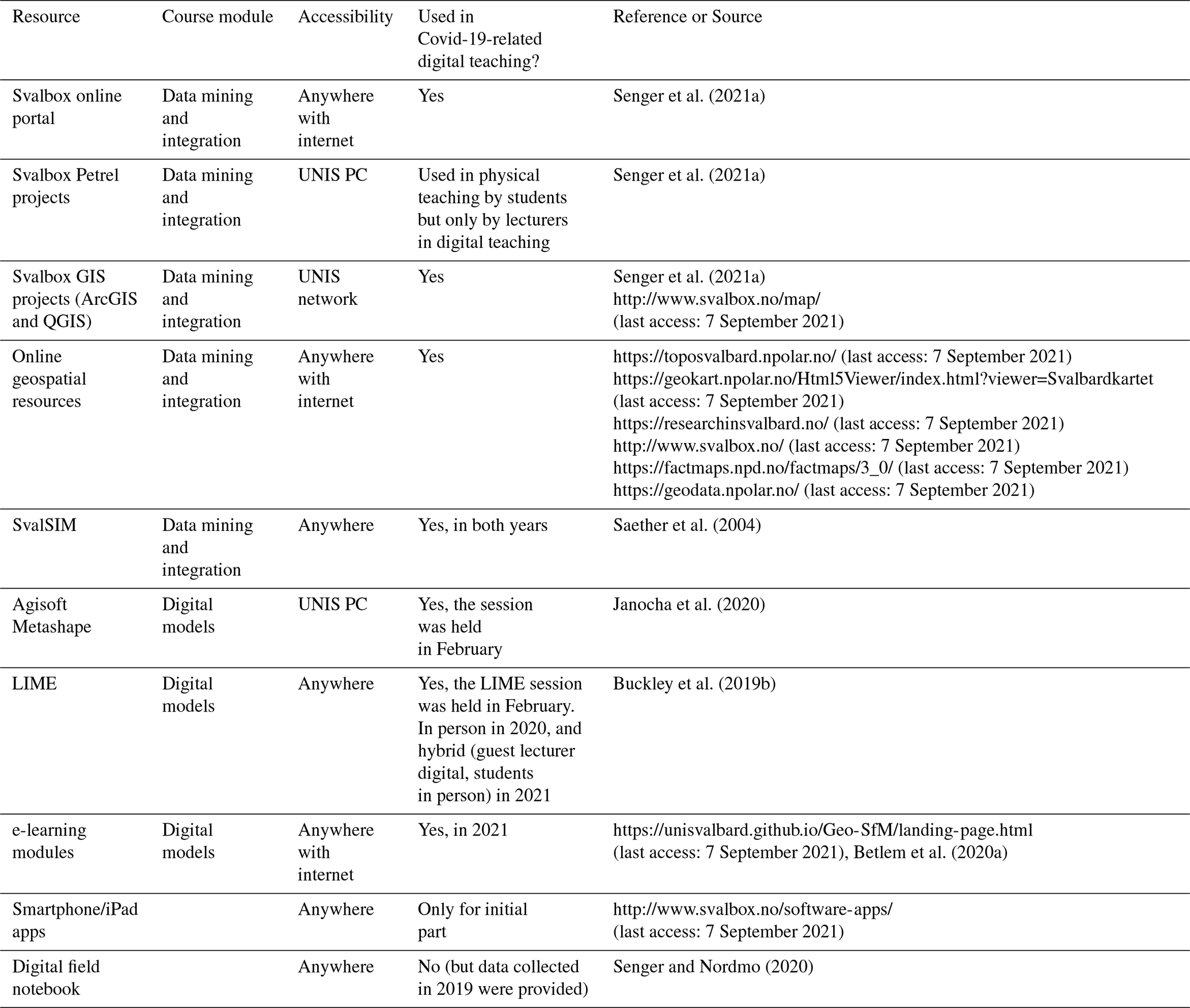
Table 5Examples of virtual field trips (VFTs) available on Svalbox.

Virtual field trips (VFTs) integrate numerous elements (digital outcrop models, publications, 360∘ imagery, photos, geological maps, satellite imagery, etc.) within a geological story line suited for a specific target audience. VFTs can be actively presented to an audience or made accessible for individuals to follow at their own pace. Building a VFT is as rewarding as following one, as it fosters creativity and group work. Furthermore, the oral presentation of the VFT by the student groups simulates authentic experiences of presenting at international conferences.
A central assignment in AG222 (25 % of course grade) involves the students developing a VFT to a given location and presenting it to a wider audience (i.e., the AG222 class, AG222 guest lecturers and UNIS geology staff). The task is conducted from the onset of the course and finalizes by the end of February when the light slowly returns to Longyearbyen. As such, the students only use provided material and data to develop a catchy and creative VFT. From 2018 to 2020, VFTs were organized as in-person presentations, where all elements were linked through a standard presentation (PowerPoint or Prezi). From 2021, we have adopted the online ArcGIS StoryMaps approach to develop the VFTs (Table 5). StoryMaps is a commercial product, but a site license is available at UNIS for its unlimited usage. This allows for more creativity with respect to directly embedding DOMs, videos and other central elements. As a further benefit, the resulting VFTs are permanently available on the Svalbox portal (http://www.svalbox.no/virtual-field-trips/, last access: 7 September 2021) for further exposure and to contribute to a growing VFT database from Svalbard. Table 4 provides the key public-domain resources and tools required to design the Svalbard VFT experience.
Seismic modelling allows for the direct correlation of outcrops with seismic data, aiding to quantify what geological features are visible on the latter. By creating geomodels from digital outcrop models, students also truly appreciate several factors that control seismic images. Building geomodels involves conducting line interpretations on digital outcrops to establish the structures, then assigning elastic properties (P- and S-wave velocity and density) to these from literature or borehole data crossing the same stratigraphic interval of interest. Once both structures and elastic properties are in place, seismic modelling is applied (e.g., Rabbel et al., 2018; Anell et al., 2016). Noise is usually also added for more realistic results (Lubrano-Lavadera et al., 2019). The synthetic seismic profiles are then overlain on the DOM and class discussions focus on understanding what geological features are discernible and how seismic acquisition parameters (primarily frequency and illumination angle) affect seismic imaging.
In AG222, the Triassic succession at Kvalpynten in south-western Edgeøya (https://v3geo.com/model/90, last access: 7 September 2021; Anell et al., 2016; Smyrak-Sikora et al., 2020b) was primarily used from 2018 to 2020 as a very well-exposed and well-studied case study (Fig. 7). The “seismic-scale” outcrop displays two contrasting geological features. The lower part of the outcrop is dominated by growth faults with small half-grabens infilled by siliciclastic syn-sedimentary deposits. In the upper part, very low-angle clinoforms related to the progradation of the world's largest delta plain in the Triassic (Klausen et al., 2019) are barely apparent even at the ca. 7 km long outcrop.

Figure 7Examples from seismic modelling of the Kvalpynten digital outcrop model (https://v3geo.com/model/90, last access: 7 September 2021) conducted by the 2019 AG222 class on a ca. 2 km long part of the outcrop. (a) Interpretation of digital outcrop model using LIME. (b) Assignment of elastic parameters to specific lithologies. (c) Seismic modelling under varying dominant frequencies using SeisRoX. (d) Direct overlay of the seismic model on the DOM.
The license claim application is an intensive group assessment worth 30 % of the AG222 grade, conducted in an intensive 3.5-week period building around the main 4 d AG222 field excursion to the Billefjorden Trough. The application follows a strict template, as do authentic license applications, and this challenges the students to compile a convincing overview of the petroleum system elements to secure a fictive claim in the field area (Fig. 8). Furthermore, an exact drilling location and well prognosis to 1300–1600 m depth must be provided, along with subsurface correlations and environmental considerations relating to petroleum exploration of this sensitive area.
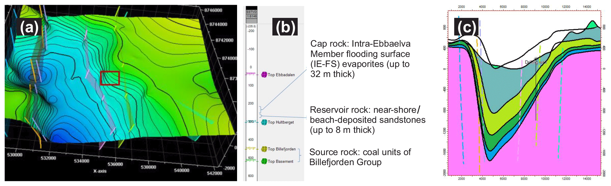
Figure 8Examples from the Billefjorden license claim assignment, conducted by the 2019 AG222 class. (a) Top reservoir structure contour map with fault zones and the area to be fictionally claimed (red rectangle). (b) Well prognosis, illustrating key petroleum system elements like source and reservoir rocks. (c) East–west cross section across the proposed drill site.
This assignment is by far the most authentic of all AG222 tasks, as the only oil discovery in Svalbard was reported from the area, which is a consequence of coal exploration by the Russian company Trust Arktikugol in the 1990s (Senger et al., 2019). Indeed, there were concrete plans as late as 2004 to drill a serious petroleum exploration borehole in the area (Senger et al., 2019). Obviously, these plans never materialized, but the AG222 students can experience this authenticity and make full use of their geological understanding to compete between the groups for the best overall license claim application.
The students integrate pre-existing material to learn as much as they can about the Billefjorden Trough prior to the field excursion, including exposure to DOMs from summer field work and a comprehensive Petrel project of the basin (including wells, published cross sections, digital terrain model, satellite imagery, geological maps). During the field campaign, students get both a basin-scale exposure at overview stops but also collect samples and information (structural and sedimentological data) to be used in their application. The digital field notebook (Senger and Nordmo, 2020) is used to organize each group's field data, and the resulting FieldMove project is a compulsory appendix to the license claim application.
A core shed near UNIS stores more than 60 km of drill cores collected by the local mining company SNSK (Store Norske Spitsbergen Kulkompani) for coal exploration and for scientific purposes (e.g., UNIS CO2 lab; Olaussen et al., 2019). The stratigraphy covers the successions outcropping in the mountainsides near Longyearbyen. Since geologists from the mining company have contributed to teaching at UNIS for almost 2 decades, it was natural to make this unique material available for student learning. Accompanied by the company geologist, students visit the shed to get first-hand knowledge about diamond drilling in the high Arctic, and sedimentary drill core logging. They practice detailed logging of cores and logging under time pressure, role-playing that bad weather is coming and the helicopter waiting to pick them up, the latter often the case for real Arctic drill site geologists. These exercises help them to understand the geology of the surrounding mountain, and they build the basis for later field-logging exercises, be it outcrop scale or making rough logs of mountainsides from the distance.
By early May, the snow begins to melt, and outcrops near Longyearbyen allow for conducting some meaningful fieldwork along one of Svalbard's arguably best exposures: the ca. 2 km continuous outcrop transect between Longyearbyen and the airport. The transect excellently exposes a succession of alternating sandstones, siltstones and shales of Early Cretaceous age, thus enabling high-resolution bed-to-bed scale investigations, as well as lateral tracing and mapping of depositional elements. In addition, ca. 4.5 km of drill cores are available from parts of the Mesozoic succession drilled by the UNIS CO2 lab project (Olaussen et al., 2019). These cores penetrate the same succession that is exposed in the Flyplassveien outcrop. The combination of outcrops and drill cores allow for a detailed and integrated sedimentological and structural characterization of the investigated succession. The students focus on and practice various methods for acquiring and presenting sedimentological and structural data. Structural data are, for example, collected both with a traditional compass and by using digital tools like tablets and smartphones (Novakova and Pavlis, 2017). In recent years, selected drill cores are digitized using SfM photogrammetry (Betlem et al., 2020b) and shared on Svalbox.
The collected scan-line data are discussed in regard to the mechanical stratigraphy of the succession, particularly focusing on how bed thickness and lithology correlate with fracture intensity. In addition, field data are integrated with DOM data to extend the area of investigation to include the inaccessible parts of the outcrop. This also increases the length of the field season that is notoriously short in the high Arctic.
Svalbard's geological record provides a unique window into deep-time palaeoclimatic events of global significance (Senger et al., 2021b). The Permian–Triassic boundary (P-Tr; Zuchuat et al., 2020) and the Paleocene–Eocene Thermal Maximum (PETM; Dypvik et al., 2011) are just two examples of globally significant events preserved in Svalbard's rock record and studied in detail in drill cores from Svalbard. The P-Tr boundary was targeted by the last drilling in Svalbard, with two ca. 100 m deep research boreholes drilled and fully cored at Deltadalen in 2014 (Zuchuat et al., 2020).
The AG222 students finalize the course with an individual poster presentation that presents a “Deltadalen-style” drilling proposal for a 100–200 m deep palaeoclimate research borehole to target an assigned interval of interest (Snowball Earth; end Permian mass extinction; Early Cretaceous oceanic anoxic events; PETM). As with the petroleum drilling in Billefjorden, the students need to utilize all their skill sets to find a suitable location and propose a realistic concrete target including a well prognosis. The assignment is individual, and its presentation at the final day of the AG222 course provides an authentic experience in presenting posters at scientific conferences.
12.1 Digital outcrop models – a game changer for digital teaching
DOMs are in our opinion a cornerstone of the ongoing geoscience revolution and a game changer for digital geoscience teaching methods (Fig. 9). DOMs are multi-scaled features and thus allow for the easy appreciation of resolution (i.e., pixel resolution, in other words the size of the smallest discernible objects), scale (i.e., size of the DOM) and perspective (i.e., viewing angle and exaggeration). DOMs can be generated across all scales, from seismic-scale outcrops to high-resolution drill core or hand sample models, and facilitate quantitative geology, including unprecedented possibilities for making realistic outcrop-based geological models (e.g., Larssen et al., 2020). Integration of DOMs with shallow geophysical data, e.g ground-penetrating radar (GPR), also opens up to “see” geology beyond the outcrop, as illustrated with the palaeokarst at Fortet (Video 5 in the Video supplement; The Billefjorden Trough STOP 6-update available at https://www.youtube.com/watch?v=Dp2m8o16SoQ, last access: 7 September 2021) (Janocha et al., 2020). Along with the explosion in cost-effective DOM acquisition from drones, the ease of sharing them with the global geoscience community through a multitude of 3D platforms (e.g., Sketchfab or V3Geo) and rendering libraries (e.g., Potree or Unity) truly opens up for global digital geology teaching.

DOMs complement traditional field data collection by facilitating data acquisition in inaccessible areas, provide greater structural data sampling and reduce time spent in the field (Nesbit et al., 2020; Pringle et al., 2006; McCaffrey et al., 2010). Furthermore, DOMs are ideal for training and teaching geology, as they allow for appreciation of structures from different perspectives and vertical exaggerations, student–teacher discussions in a controlled indoor environment, and (digital) accessibility to the field irrespective of the participants field experience or economic and cultural background.
DOMs, particularly when derived from drone-based photographs, make inaccessible outcrops safely accessible without the risk of rock fall, avalanches, climate issues, steep and rocky terrains, or wildlife (e.g., polar bears, rattlesnakes). Precisely acquired DOMs allow geologists to extract and present quantitative and qualitative geological information and detailed measurements without the need to directly access them (Larssen et al., 2020; Marques et al., 2020; Senger et al., 2015a; Nesbit et al., 2020, 2018). This approach increases the areas from which measurements can be made, which means that more statistical information can be collected, increasing the sample size and therefore reducing errors in statistical analysis (Fabuel-Perez et al., 2010; García-Sellés et al., 2011; Hodgetts, 2013).
In the same way, new attributes can be generated to highlight subtle features, helping in the interpretation by providing the basis for automated mapping approaches (McCaffrey et al., 2005, 2010). These either reduce the time needed for fieldwork or make fieldwork more efficient with more data acquired over the same time interval. For comparison, Ogata et al. (2014) present >9000 structural measurements of fractures collected on a sandstone in Svalbard over a 1-month field period, while recently acquired DOMs in the same area would exponentially reduce the time needed to collect the same data. The reduced cost of fieldwork by active use of DOMs and VFTs is also considerable, both in industry and academia. This is especially relevant when entire teams should investigate outcrops together and discuss while observing the outcrop. However, DOMs are still not a replacement for traditional field trips but a tool that can improve the field experience (Hodgetts, 2013), making it an efficient way to integrate and visualize multi-scalar surface and subsurface rock data in desktop applications. The increased use of immersive virtual reality (iVR) already provides authentic digital field experiences (Gonzaga et al., 2018), and only the resolution and spatial limits of individual DOMs set the boundaries of what is possible.
12.2 Course development and integration with Svalbox portal
The AG222 course was developed in parallel with the Svalbox portal, and this synergy will be optimized also in the coming years (Fig. 10). The skills-based course requires relevant and authentic data sets for the authentic experiences, which is provided through Svalbox. On the other hand, the AG222 course provides content to the Svalbox portal, in particular virtual field trips developed by both staff and students. Similarly, UNIS-affiliated research projects including MSc and PhD students contribute data sets to Svalbox, in particular DOMs and 360∘ images. Over time, we envision that this will lead to a rapid increase in DOMs from Svalbard openly available for the global geoscience community.
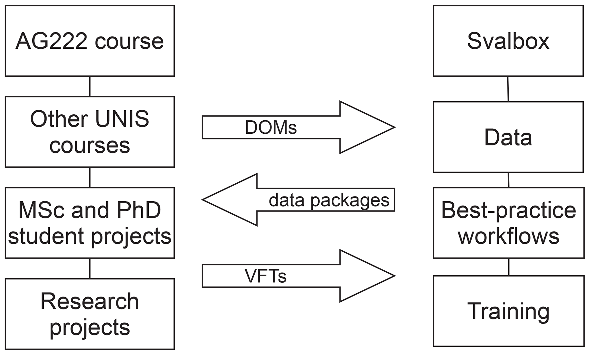
Figure 10Schematic diagram of the synergies between the AG222 course (and other UNIS courses and research activities) and the Svalbox portal.
It must be noted that the AG222 course is inspired by state-of-the-art training offered in the petroleum industry, with expert teams working together to solve authentic “real-world” problems. It is thus imperative that the skills the students acquire as part of the course are applicable in the students' future careers irrespective of sector. In addition to the technical skills learnt during the course, extra skills such as data management, group work and handling intensive periods with heavy workloads are important elements to make the AG222 course as authentic as possible.
12.3 Field-based training for the petroleum industry and communication to the broader society
We can regard Svalbard as the exposed part of the subsurface of the Barents Sea, with ongoing petroleum exploration and production. UNIS has over the past decade run excursions for the oil industry, particularly to localities exhibiting Carboniferous to Lower Cretaceous strata. Those strata are linked to the proven reservoirs and source rocks in the efficient petroleum systems in the southwestern Barents Sea petroleum province. The main purpose of these field-based educational expeditions for the industry is to train the geological and geophysical staff in the regional overview of the basins, tectonism, architecture and scale of reservoirs. The excursion/field trip is run by a medium-sized ship capable of accommodating 20 passengers. Although geological guides are handed out, presentations are given in the evening of what to see the next day and are repeated the next morning, it is challenging to present the localities as relevant for the normal “work station scale” (e.g., Petrel, Landmark) at the office. However, if the participants upfront on their own computer play with a DOM of the specific outcrop to be visited, it will be possible to better understand the scale and architecture of the geology to be visited. We thus foresee enhanced use of Svalbox in such targeted field campaigns, particularly when the Covid-19 pandemic passes and such excursions once again become feasible.
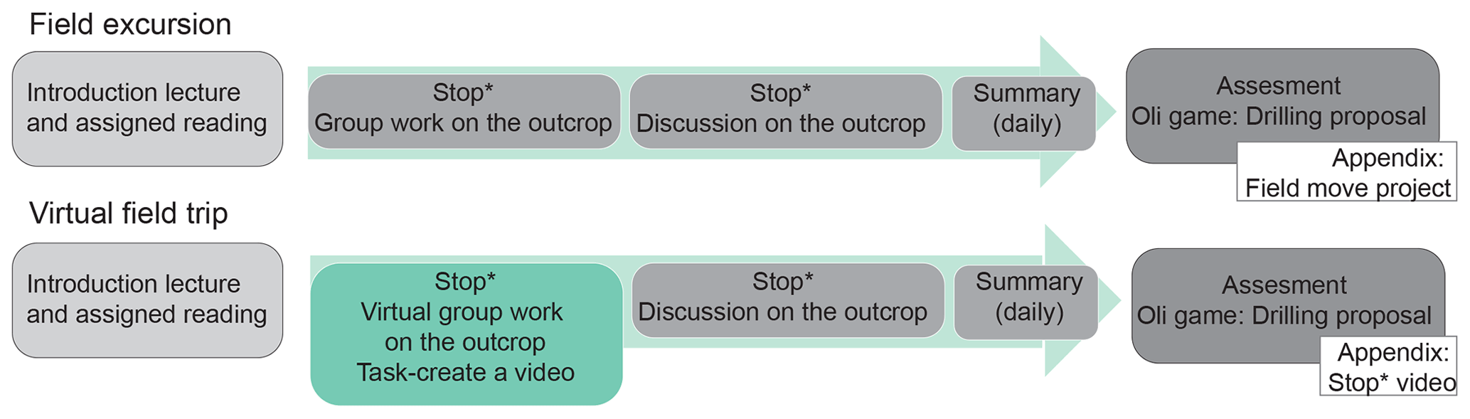
Figure 11Consequences of the Covid-19 pandemic on the AG222 assessment related to the license claim application.
12.4 Covid-19 implications
On 13 March 2020, the Covid-19 pandemic forced the cancellation of all fieldwork at UNIS. Seventeen bachelor students were able to continue remotely as courses running at the time were continued digitally. The original plan included a 4 d long snowmobile field trip to the Carboniferous rift basin located in central Spitsbergen. The structure of the excursion was kept as close to the original plan as possible (Fig. 11). Instead of the work at a real outcrop, students were tasked with preparing “digital geological stops” of assigned sites throughout the basin and present these to the entire class through a publicly available video (Green box in Fig. 11; see the playlist here: https://www.youtube.com/watch?v=_Izk4yhEN2Y&list=PLaERIU24EpWf93UbEB701vFTqwBPG6CpY, last access: 7 September 2021). The videos included DOMs from Svalbox, geological maps, aerial images, Google Earth overviews, georeferenced photos, and measurements and notes from FieldMove projects compiled by students taking the course in previous years. Following the presentation of these field guides, additional information and discussions were facilitated by the lecturers. The students, in groups of 3–4, were tasked to identify potential hydrocarbon prospects and apply for a fictional claim application in Billefjorden, as described above.
The qualitative feedback collected from the students and teachers clearly points out that the virtual field excursions cannot replace real field experience. Principal geological tests such as Mohs hardness tests, grain/crystal size analysis or ground-truthing structural orientation measurements, which are a foundation of bachelor-level courses, cannot be performed virtually. Virtual field excursions can, however, contribute to the field-based education and serve as an introduction to the study area and function as a substitute for snow-covered or inaccessible localities or when a planned field excursion needs to be adapted to harsh weather conditions. Ultimately, our experience suggests that there are real benefits to virtual excursions only if it is combined with real field work of the same or comparable geology.
12.5 Future perspectives
The AG222 course will continue to be offered every year and thus allows for sustainable and incremental optimization through integrating emerging tools. At the moment, we are developing open-access online modules for all the course modules, inspired by the successful Geo-SfM course module (Table 1). In addition, we are continuously testing new tools, for instance smartphones and tablet with in-built lidar scanners (e.g., iPhone 12 Pro, 3D printers, VR technologies, thermal cameras, drone-mounted sensors), to push the boundaries of digital geological techniques. Perhaps more importantly than testing and sharing experiences from new hardware are the efforts to outline best practice documents for the many important cross-software workflows, along the from outcrop to geomodel framework.
Our overall vision is that the Svalbox platform will facilitate free and easy access to all the collected data elements. This innovative approach building on FAIR (i.e., findable, accessible, interoperable and reusable) data principles (Mons et al., 2017) and the open data movement will exponentially enhance the use of Svalbox DOMs beyond UNIS and contribute to squeezing out more information from already collected data. This approach applies not just to the data sets but also tools to be used. Both StoryMaps and Petrel are licensed software, though with academic rates (Petrel is, for instance, at the time being available for free for academic institutions like UNIS). In the future, we envision testing and potentially adopting open-source solutions for the entire Svalbox value chain. The ongoing digitization efforts of the subsurface (e.g., Nguyen et al., 2020), of vital importance for many geo-energy applications (e.g., petroleum exploration and production, CO2 storage, geothermal energy, gas and nuclear waste storage), will be able to use DOMs from a range of lithologies to test and train algorithms to facilitate the (semi-)automatic interpretation of the outcrops, including machine learning and big data analyses. Furthermore, geoscientists will ideally be able to put together all Svalbox elements into thematic virtual field trips at a click of a button. Similarly, educators at UNIS and beyond can already now use Svalbox elements to generate online and class-based course modules. As an example, UNIS staff are currently involved in developing two course modules, “Deep-time paleoclimate in the Svalbard rock record” and “Petroleum systems of Svalbard”, to be offered also to students not physically in Svalbard.
In this contribution, we have outlined a Bachelor-level course on integrated geological methods developed at the world's northernmost university in Longyearbyen, Svalbard. The focus on digital tools, and in particular digital outcrops, not only extends the short Arctic field season but also facilitated running the second half of the course fully digitally during the global Covid-19 pandemic in 2020.
We have provided an overview of the main course elements. We conclude that the digital geoscience revolution is among us and that we as educators need to embrace it – not to replace traditional fieldwork but to complement it and exploit the synergies. There is no better place in the world than Svalbard to do this – as digital geology also significantly enhances our field season, and the geology of Svalbard is truly a playground for any geologist. The Svalbox portal is our contribution to open up this playground to the global geoscientific community.
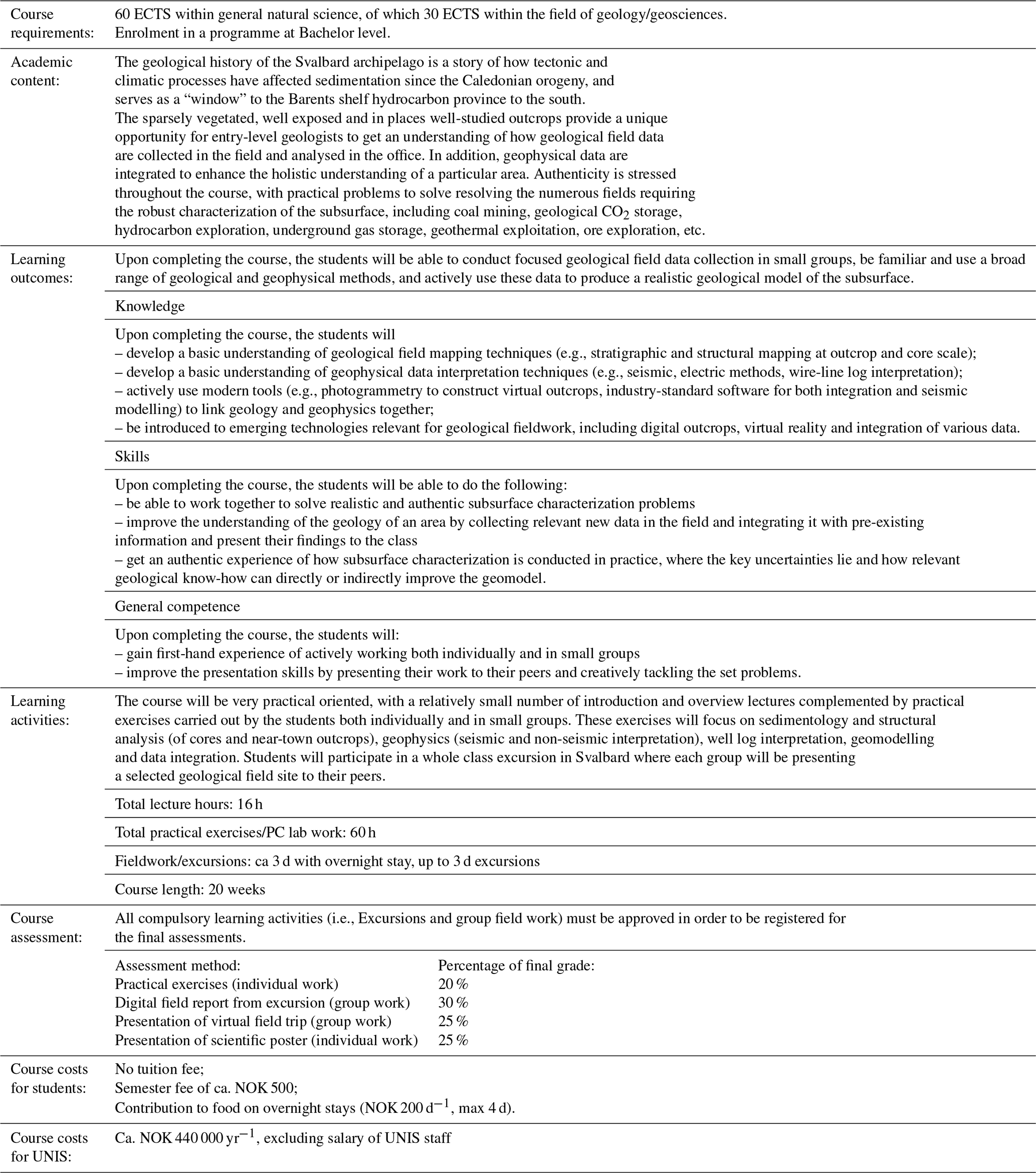
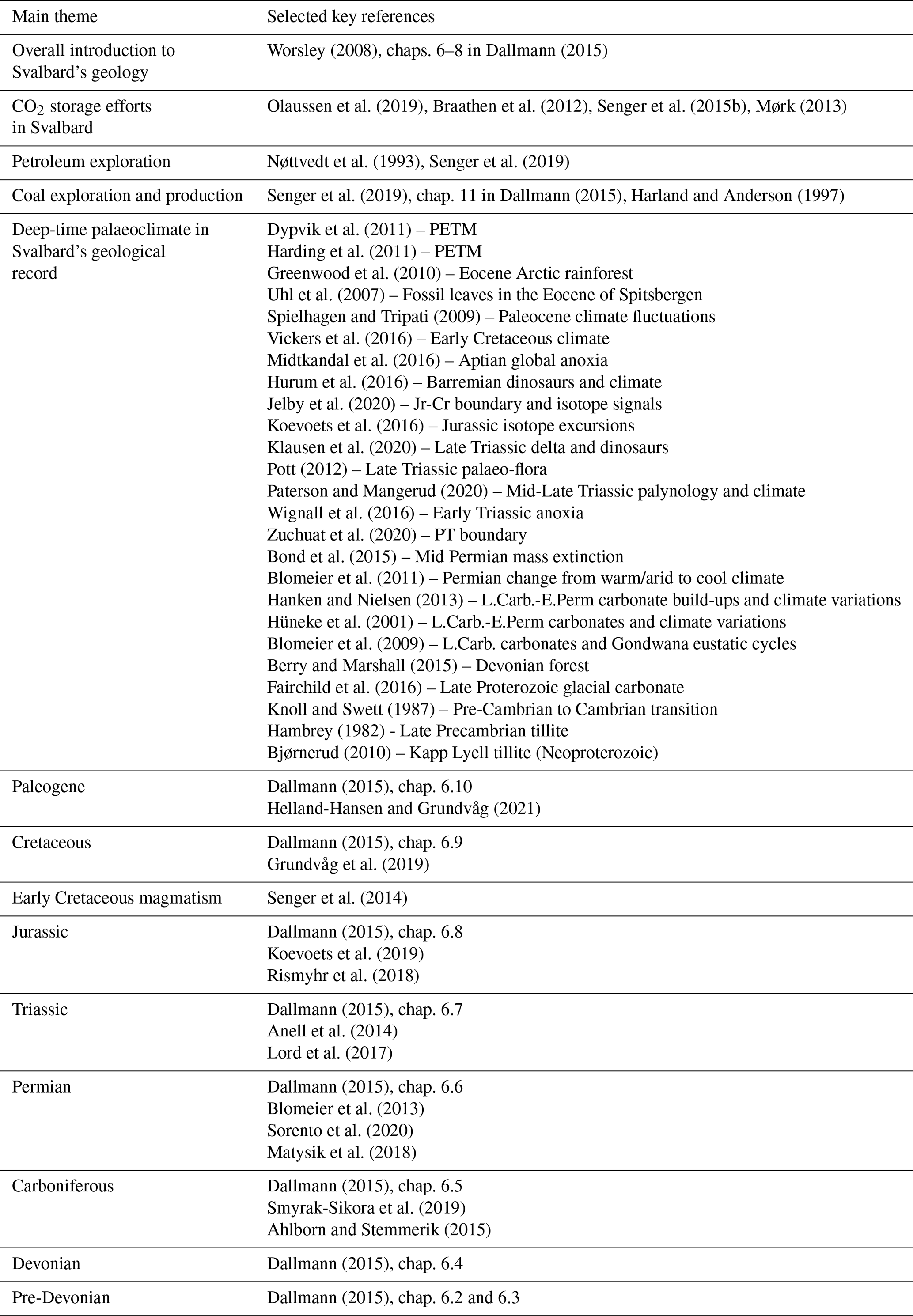
Table A2Key literature on Svalbard's geological evolution and main thematic topics.
Code is available via the Svalbox GitHub repository, https://github.com/svalbox/Cookbook (last access: 7 September 2021, Betlem, 2019).
Digital outcrop models are available via http://www.svalbox.no/map (last access: 7 September 2021, Senger and Betlem, 2021), and Svalbox Petrel projects are available from Kim Senger for non-commercial projects. Some models are available via https://v3geo.com/ (last access: 7 September 2021, V3Geo, 2021).
Both the Svalbox portal and AG222 course are visually presented in a series of videos on the Svalbox YouTube channel (https://www.youtube.com/channel/UCQ7tTHrKaKSBB7fxUpnabeQ, last access 20 September 2021).
AG222 course overview: https://www.youtube.com/watch?v=Pjr-4L5zqE8 (last access: 7 September 2021; Johannessen, 2021).
Svalbox overview video: Discover Svalbard's Geology with Svalbox (https://www.youtube.com/watch?v=gJR-qp5XMsw&t=2s, last access: 7 September 2021; Janocha et al., 2021).
The 360∘ video from 2020 Botneheia excursion: https://www.youtube.com/watch?v=w1XHoM1BlCM (last access: 7 September 2021; Horota, 2020).
The supplement related to this article is available online at: https://doi.org/10.5194/gc-4-399-2021-supplement.
KS conceptualized the paper. PB, TB, JJ and KS curated the data. Funding was acquired by KS, IL, SB and SO. The software was arranged by PB and SB. KS, RKH, AS, TB, JJ, LK and RMJ visualized the project. KS wrote and prepared the original draft. The review and editing of the paper was done by KS, PB, SAG, RKH, SJB, AS, MMJ, TB, JJ, KO, LK, RMJ, IL, SMC and SO.
The authors declare that they have no conflict of interest.
Publisher’s note: Copernicus Publications remains neutral with regard to jurisdictional claims in published maps and institutional affiliations.
This article is part of the special issue “Virtual geoscience education resources”. It is not associated with a conference.
The AG222 course is fully financed by UNIS, with significant course and Svalbox development costs financed through numerous co-operation grants from the University of the Arctic (UArctic). Digital outcrop models freely available on Svalbox are acquired using both UNIS internal funds and external projects, notably the Research Centre for Arctic Petroleum Exploration (ARCEx), the Norwegian CCS Research Centre (NCCS), the Suprabasins project led by the University of Oslo and the Petroleum Research School of Norway (NfiP). The iEarth Centre for Integrated Earth Science Education provided seed funds to develop a virtual field trip to Festningen. The VOG Group at NORCE added a selection of Svalbox models to the V3Geo portal. We sincerely appreciate all feedback from UNIS colleagues and data sharing from MSc and PhD students and – of course – all the students of the AG222 course at UNIS over the years.
This research has been supported by the University of the Arctic (grants CAGE, HalipDAT, and Svalbox2020) and ARCEx partners and the Research Council of Norway (grant no. 228107).
This paper was edited by Sam Illingworth and reviewed by Martin Bohle and Rachel Bosch.
Ahlborn, M. and Stemmerik, L.: Depositional evolution of the Upper Carboniferous-Lower Permian Wordiekammen carbonate platform, Nordfjorden High, central Spitsbergen, Arctic Norway, Norw. J. Geol., 95, 91–126, 2015.
Anell, I., Braathen, A., and Olaussen, S.: The Triassic-Early Jurassic of the northern Barents Shelf: a regional understanding of the Longyearbyen CO2 reservoir, Norw. J. Geol., 94, 83–98, 2014.
Anell, I., Lecomte, I., Braathen, A., and Buckley, S.: Synthetic seismic illumination of small-scale growth faults, paralic deposits and low-angle clinoforms: A case study of the Triassic successions on Edgeøya, NW Barents Shelf, Mar. Petrol. Geol., 77, 625–639, https://doi.org/10.1016/j.marpetgeo.2016.07.005, 2016.
Beka, T. I., Senger, K., Autio, U. A., Smirnov, M., and Birkelund, Y.: Integrated electromagnetic data investigation of a Mesozoic CO2 storage target reservoir-cap-rock succession, Svalbard, J. Appl. Geophys., 136, 417–430, 2017.
Bergen, K. J., Johnson, P. A., Maarten, V., and Beroza, G. C.: Machine learning for data-driven discovery in solid Earth geoscience, Science, 363, eaau0323, https://doi.org/10.1126/science.aau0323, 2019.
Berry, C. M. and Marshall, J. E.: Lycopsid forests in the early Late Devonian paleoequatorial zone of Svalbard, Geology, 43, 1043–1046, 2015.
Betlem, P.: Virtual Outcrop Models/Synthetic seismic, GitHub [code], available at: https://github.com/svalbox/Cookbook (last access: 20 September 2021), 2019.
Betlem, P., Birchall, T., Mosociova, T., Sartell, A. M. R., and Senger, K.: From seismic-scale outcrop to hand sample: streamlining SfM photogrammetry processing in the geosciences, ARCEx annual conference, digital, available at: https://arcex.no/arcex-2020/ (last access: 7 September 2021), 2020a.
Betlem, P., Birchall, T., Ogata, K., Park, J., Skurtveit, E., and Senger, K.: Digital Drill Core Models: Structure-from-Motion as a Tool for the Characterisation, Orientation, and Digital Archiving of Drill Core Samples, Remote Sens., 12, 330, https://doi.org/10.3390/rs12020330, 2020b.
Bjørnerud, M.: Stratigraphic record of Neoproterozoic ice sheet collapse: the Kapp Lyell diamictite sequence, SW Spitsbergen, Svalbard, Geol. Mag., 147, 380–390, 2010.
Blomeier, D., Scheibner, C., and Forke, H.: Facies arrangement and cyclostratigraphic architecture of a shallow-marine, warm-water carbonate platform: the Late Carboniferous Ny Friesland Platform in eastern Spitsbergen (Pyefjellet Beds, Wordiekammen Formation, Gipsdalen Group), Facies, 55, 291–324, 2009.
Blomeier, D., Dustira, A., Forke, H., and Scheibner, C.: Environmental change in the Early Permian of NE Svalbard: from a warm-water carbonate platform (Gipshuken Formation) to a temperate, mixed siliciclastic-carbonate ramp (Kapp Starostin Formation), Facies, 57, 493–523, 2011.
Blomeier, D., Dustira, A. M., Forke, H., and Scheibner, C.: Facies analysis and depositional environments of a storm-dominated, temperate to cold, mixed siliceous-carbonate ramp: the Permian Kapp Starostin Formation in NE Svalbard, Norw. J. Geol., 93, 75–93, 2013.
Bond, C. E. and Cawood, A. J.: A role for virtual outcrop models in blended learning – improved 3D thinking and positive perceptions of learning, Geosci. Commun., 4, 233–244, https://doi.org/10.5194/gc-4-233-2021, 2021.
Bond, D. P., Wignall, P. B., Joachimski, M. M., Sun, Y., Savov, I., Grasby, S. E., Beauchamp, B., and Blomeier, D. P.: An abrupt extinction in the Middle Permian (Capitanian) of the Boreal Realm (Spitsbergen) and its link to anoxia and acidification, GSA Bulletin, 127, 1411–1421, 2015.
Braathen, A., Bælum, K., Christiansen, H. H., Dahl, T., Eiken, O., Elvebakk, H., Hansen, F., Hanssen, T. H., Jochmann, M., Johansen, T. A., Johnsen, H., Larsen, L., Lie, T., Mertes, J., Mørk, A., Mørk, M. B., Nemec, W. J., Olaussen, S., Oye, V., Rød, K., Titlestad, G. O., Tveranger, J., and Vagle, K.: Longyearbyen CO2 lab of Svalbard, Norway – first assessment of the sedimentary succession for CO2 storage, Norw. J. Geol., 92, 353–376, 2012.
Buckley, S. J., Howell, J. A., Enge, H. D., and Kurz, T. H.: Terrestrial laser scanning in geology: data acquisition, processing and accuracy considerations, Journal of the Geological Society, 165, 625–638, 10.1144/0016-76492007-100, 2008.
Buckley, S. J., Naumann, N., Ringdal, K., Tong, B., Vanbiervliet, J., Chmielewska, M., Maxwell, G., and Howell, J.: The digital geoscience revolution – where are we now?, APGCE 2019, 1–5, 2019a.
Buckley, S. J., Ringdal, K., Naumann, N., Dolva, B., Kurz, T. H., Howell, J. A., and Dewez, T. J.: LIME: Software for 3-D visualization, interpretation, and communication of virtual geoscience models, Geosphere, 15, 222–235, 2019b.
Cartwright, J. and Huuse, M.: 3D seismic technology: the geological “Hubble”, Basin Res., 17, 1–20, 2005.
Cawood, A. J. and Bond, C. E.: eRock: An open-access repository of virtual outcrops for geoscience education, GSA Today, 36–37, https://doi.org/10.1130/GSATG373GW.1, 2019.
Dallmann, W. K. (Ed.): Geoscience Atlas of Svalbard, Norsk Polarinstitutt, Rapportserie nr. 148, 292 pp., 2015.
Dypvik, H., Riber, L., Burca, F., Rüther, D., Jargvoll, D., Nagy, J., and Jochmann, M.: The Paleocene–Eocene thermal maximum (PETM) in Svalbard–clay mineral and geochemical signals, Palaeogeogr. Palaeocl., 302, 156–169, 2011.
Fabuel-Perez, I., Hodgetts, D., and Redfern, J.: Integration of digital outcrop models (DOMs) and high resolution sedimentology–workflow and implications for geological modelling: Oukaimeden Sandstone Formation, High Atlas (Morocco), Petrol. Geosci., 16, 133–154, 2010.
Fairchild, I. J., Fleming, E. J., Bao, H., Benn, D. I., Boomer, I., Dublyansky, Y. V., Halverson, G. P., Hambrey, M. J., Hendy, C., and McMillan, E. A.: Continental carbonate facies of a Neoproterozoic panglaciation, north-east Svalbard, Sedimentology, 63, 443–497, 2016.
García-Sellés, D., Falivene, O., Arbués, P., Gratacos, O., Tavani, S., and Muñoz, J. A.: Supervised identification and reconstruction of near-planar geological surfaces from terrestrial laser scanning, Comput. Geosci., 37, 1584–1594, 2011.
Gonzaga, L., Veronez, M. R., Kannenberg, G. L., Alves, D. N., Santana, L. G., de Fraga, J. L., Inocencio, L. C., de Souza, L. V., Boirdin, F., Tognoli, F. M. W., Senger, K., and Cazarin, C. L.: MOSIS – Multi-Outcrop Sharing & Interpretation System, IEEE Geoscience and Remote Sensing Magazine, 6, 8–16, https://doi.org/10.1109/MGRS.2018.2825990, 2018.
Greenwood, D. R., Basinger, J. F., and Smith, R. Y.: How wet was the Arctic Eocene rain forest? Estimates of precipitation from Paleogene Arctic macrofloras, Geology, 38, 15–18, 2010.
Grundvåg, S.-A., Jelby, M. E., Sliwinska, K. K., Nøhr-Hansen, H., Aadland, T., Sandvik, S. E., Tennvassås, I., Engen, T., and Olaussen, S.: Sedimentology and palynology of the Lower Cretaceous succession of central Spitsbergen: integration of subsurface and outcrop data, Norw. J. Geol., 99, 1–32, 2019.
Guo, H., Wang, L., Chen, F., and Liang, D.: Scientific big data and digital earth, Chinese Sci. Bull., 59, 5066–5073, 2014.
Hambrey, M.: Late Precambrian diamictites of northeastern Svalbard, Geol. Mag., 119, 527–551, 1982.
Hanken, N.-M. and Nielsen, J. K.: Upper Carboniferous–Lower Permian Palaeoaplysina build-ups on Svalbard: the influence of climate, salinity and sea-level, Geological Society, London, Special Publications, 376, 269–305, 2013.
Harding, I. C., Charles, A. J., Marshall, J. E., Pälike, H., Roberts, A. P., Wilson, P. A., Jarvis, E., Thorne, R., Morris, E., and Moremon, R.: Sea-level and salinity fluctuations during the Paleocene–Eocene thermal maximum in Arctic Spitsbergen, Earth Planet. Sc. Lett., 303, 97–107, 2011.
Harland, W. and Anderson, L.: Appendix: Economic geology: exploration for coal, oil and minerals, in: Geology of Svalbard, edited by: Harland, W., The Geological Society, Bath, UK, 449–454, 1997.
Helland-Hansen, W. and Grundvåg, S. A.: The Svalbard Eocene-Oligocene (?) Central Basin succession: Sedimentation patterns and controls, Basin Res., 33, 729–753, 2021.
Hodgetts, D.: Laser scanning and digital outcrop geology in the petroleum industry: a review, Mar. Petrol. Geol., 46, 335–354, 2013.
Horota, R.: AG222 excursion @ UNIS – February 2020, YouTube, available at: https://www.youtube.com/watch?v=w1XHoM1BlCM, last access: 7 September 2021), 2020.
Howell, J. A., Martinius, A. W., and Good, T. R.: The application of outcrop analogues in geological modelling: a review, present status and future outlook, in: Sediment-Body Geometry and Heterogeneity: Analogue Studies for Modelling the Subsurface, edited by: Martinius, A. W., Howell, J. A., and Good, T. R., Geological Society of London, London, 1–25, 2014.
Hurum, J. H., Druckenmiller, P. S., Hammer, Ø., Nakrem, H. A., and Olaussen, S.: The theropod that wasn't: an ornithopod tracksite from the Helvetiafjellet Formation (Lower Cretaceous) of Boltodden, Svalbard, Geological Society, London, Special Publications, 434, 189–206, 2016.
Hüneke, H., Joachimski, M., Buggisch, W., and Lützner, H.: Marine carbonate facies in response to climate and nutrient level: the Upper Carboniferous and Permian of Central Spitsbergen (Svalbard), Facies, 45, 93–135, 2001.
Janocha, J., Smyrak-Sikora, A., Senger, K., and Birchall, T.: Seeing beyond the outcrop: Integration of ground-penetrating radar with digital outcrop models of a paleokarst system, Mar. Petrol. Geol., 125, 104833, https://doi.org/10.1016/j.marpetgeo.2020.104833, 2020.
Janocha, J., Birchall, T., Betlem, P., and Lord, G.: Discover Svalbard's Geology with Svalbox, YouTube, available at: https://www.youtube.com/watch?v=gJR-qp5XMsw&t=2s, last access: 7 September 2021.
Jelby, M. E., Śliwińska, K. K., Koevoets, M. J., Alsen, P., Vickers, M. L., Olaussen, S., and Stemmerik, L.: Arctic reappraisal of global carbon-cycle dynamics across the Jurassic–Cretaceous boundary and Valanginian Weissert Event, Palaeogeogr. Palaeocl., 555, 109847, https://doi.org/10.1016/j.palaeo.2020.109847, 2020.
Johannessen, R. M.: Arctic Geology – Integrated Geological Methods: from outcrop to geomodel (AG222 @ UNIS), YouTube, available at: https://www.youtube.com/watch?v=Pjr-4L5zqE8, last access: 7 September 2021.
Kastens, K. A., Manduca, C. A., Cervato, C., Frodeman, R., Goodwin, C., Liben, L. S., Mogk, D. W., Spangler, T. C., Stillings, N. A., and Titus, S.: How geoscientists think and learn, Eos T. Am. Geophys. Un., 90, 265–266, 2009.
Klausen, T. G., Nyberg, B., and Helland-Hansen, W.: The largest delta plain in Earth's history, Geology, 47, 470–474, 2019.
Klausen, T. G., Paterson, N. W., and Benton, M. J.: Geological control on dinosaurs' rise to dominance: Late Triassic ecosystem stress by relative sea level change, Terra Nova, 32, 434–441, 2020.
Knoll, A. H. and Swett, K.: Micropaleontology across the Precambrian-Cambrian boundary in Spitsbergen, J. Paleontol., 61, 898–926, 1987.
Koevoets, M. J., Abay, T. B., Hammer, Ø., and Olaussen, S.: High-resolution organic carbon–isotope stratigraphy of the Middle Jurassic–Lower Cretaceous Agardhfjellet Formation of central Spitsbergen, Svalbard, Palaeogeogr. Palaeocl., 449, 266–274, https://doi.org/10.1016/j.palaeo.2016.02.029, 2016.
Koevoets, M. K., Hammer, Ø., and Little, C. T.: Palaeoecology and palaeoenvironments of the Middle Jurassic to lowermost Cretaceous Agardhfjellet Formation (Bathonian-Ryazanian), Spitsbergen, Svalbard, Norw. J. Geol., 99, 1–24, 2019.
Larsen, T.: Fractured carbonates in the Mediumfjellet thrust-stack in the Tertiary fold-and-thrust belt of Spitsbergen, MSc thesis, Department of Arctic Geology, University of Tromsø, Tromsø, available at: https://munin.uit.no/handle/10037/1800 (last access: 7 September 2021), 2010.
Larssen, K., Senger, K., and Grundvåg, S.-A.: Fracture characterization in Upper Permian carbonates in Spitsbergen: A workflow from digital outcrop to geo-model, Mar. Petrol. Geol., 122, 104703, https://doi.org/10.1016/j.marpetgeo.2020.104703, 2020.
Lord, G. S., Johansen, S. K., Støen, S. J., and Mørk, A.: Facies development of the Upper Triassic succession on Barentsøya, Wilhelmøya and NE Spitsbergen, Svalbard, Norw. J. Geol., 97, 33–62, 2017.
Lubrano-Lavadera, P., Senger, K., Mulrooney, M., Lecomte, I., and Kuehn, D.: Seismic modelling of metre-scale normal faults at a reservoir-cap rock interface in Central Spitsbergen, Svalbard: implications for CO2 storage, Norw. J. Geol., 99, 323–341, 2019.
Marques Jr., A., Horota, R. K., de Souza, E. M., Lupssinskü, L., Rossa, P., Aires, A. S., Bachi, L., Veronez, M. R., Gonzaga Jr, L., and Cazarin, C. L.: Virtual and digital outcrops in the petroleum industry: A systematic review, Earth-Sci. Rev., 208, 103260, https://doi.org/10.1016/j.earscirev.2020.103260, 2020.
Matysik, M., Stemmerik, L., Olaussen, S., and Brunstad, H.: Diagenesis of spiculites and carbonates in a Permian temperate ramp succession–Tempelfjorden Group, Spitsbergen, Arctic Norway, Sedimentology, 65, 745–774, 2018.
McCaffrey, K., Jones, R., Holdsworth, R., Wilson, R., Clegg, P., Imber, J., Holliman, N., and Trinks, I.: Unlocking the spatial dimension: digital technologies and the future of geoscience fieldwork, Journal of the Geological Society, 162, 927–938, 2005.
McCaffrey, K., Hodgetts, D., Howell, J., Hunt, D., Imber, J., Jones, R., Tomasso, M., Thurmond, J., and Viseur, S.: Virtual fieldtrips for petroleum geoscientists, Geological Society, London, Petroleum Geology Conference series, 7, 19–26, 2010.
Midtkandal, I., Svensen, H. H., Planke, S., Corfu, F., Polteau, S., Torsvik, T. H., Faleide, J. I., Grundvåg, S.-A., Selnes, H., and Kürschner, W.: The Aptian (Early Cretaceous) oceanic anoxic event (OAE1a) in Svalbard, Barents Sea, and the absolute age of the Barremian-Aptian boundary, Palaeogeogr. Palaeocl., 463, 126–135, 2016.
Mogk, D. W. and Goodwin, C.: Learning in the field: Synthesis of research on thinking and learning in the geosciences, Geological Society of America Special Papers, 486, 131–163, 2012.
Mons, B., Neylon, C., Velterop, J., Dumontier, M., da Silva Santos, L. O. B., and Wilkinson, M. D.: Cloudy, increasingly FAIR; revisiting the FAIR Data guiding principles for the European Open Science Cloud, Information Services & Use, 37, 49–56, 2017.
Mørk, M. B. E.: Diagenesis and quartz cement distribution of low-permeability Upper Triassic – Middle Jurassic reservoir sandstones, Longyearbyen CO2 lab well site in Svalbard, Norway, AAPG Bulletin, 97, 577–596, https://doi.org/10.1306/10031211193, 2013.
Nesbit, P. R., Durkin, P. R., Hugenholtz, C. H., Hubbard, S. M., and Kucharczyk, M.: 3-D stratigraphic mapping using a digital outcrop model derived from UAV images and structure-from-motion photogrammetry, Geosphere, 14, 2469–2486, 2018.
Nesbit, P. R., Boulding, A. D., Hugenholtz, C. H., Durkin, P. R., and Hubbard, S. M.: Visualization and sharing of 3D digital outcrop models to promote open science, GSA Today, 30, 1–8, https://doi.org/10.1130/GSATG425A.1.2020, 2020.
Nguyen, T., Gosine, R. G., and Warrian, P.: A systematic review of big data analytics for oil and gas industry 4.0, IEEE Access, 8, 61183–61201, 2020.
Novakova, L. and Pavlis, T. L.: Assessment of the precision of smart phones and tablets for measurement of planar orientations: A case study, J. Struct. Geol., 97, 93–103, https://doi.org/10.1016/j.jsg.2017.02.015, 2017.
Nøttvedt, A., Livbjerg, F., Midbøe, P. S., and Rasmussen, E.: Hydrocarbon potential of the Central Spitsbergen Basin, in: Arctic Geology and Petroleum Potential, edited by: Vorren, T. O., Bergsager, E., Dahl-Stamnes, Ø. A., Holter, E., Johansen, B., Lie, E., and Lund, T. B., Elsevier, Amsterdam, 333–361, 1993.
Ogata, K., Senger, K., Braathen, A., Tveranger, J., and Olaussen, S.: Fracture systems and meso-scale structural patterns in the siliciclastic Mesozoic reservoir-caprock succession of the Longyearbyen CO2 Lab project: implications for geologic CO2 sequestration on Central Spitsbergen, Svalbard, Norw. J. Geol., 94, 121–154, 2014.
Olaussen, S., Senger, K., Braathen, A., Grundvåg, S. A., and Mørk, A.: You learn as long as you drill; research synthesis from the Longyearbyen CO2 Laboratory, Svalbard, Norway, Norw. J. Geol., 99, 157–187, https://doi.org/10.17850/njg008, 2019.
Paterson, N. W. and Mangerud, G.: A revised palynozonation for the Middle–Upper Triassic (Anisian–Rhaetian) Series of the Norwegian Arctic, Geol. Mag., 157, 1568–1592, 2020.
Pott, C.: The Upper Triassic flora of Svalbard, Acta Palaeontol. Pol., 59, 709–740, 2012.
Pringle, J. K., Howell, J. A., Hodgetts, D., Westerman, A. R., and Hodgson, D. M.: Virtual outcrop models of petroleum reservoir analogues: a review of the current state-of-the-art, First Break, 24, 33–42, 2006.
Rabbel, O., Galland, O., Mair, K., Lecomte, I., Senger, K., Spacapan, J. B., and Manceda, R.: From field analogues to realistic seismic modelling: a case study of an oil-producing andesitic sill complex in the Neuquén Basin, Argentina, Journal of the Geological Society, 175, 580, https://doi.org/10.1144/jgs2017-116, 2018.
Rismyhr, B., Bjærke, T., Olaussen, S., Mulrooney, M. J., and Senger, K.: Facies, palynostratigraphy and sequence stratigraphy of the Wilhelmøya Subgroup (Upper Triassic–Middle Jurassic) in western central Spitsbergen, Svalbard, Norsk Geol. Tidsskr., 99, 35–64, 2018.
Rittersbacher, A., Buckley, S. J., Howell, J. A., Hampson, G. J., and Vallet, J.: Helicopter-based laser scanning: a method for quantitative analysis of large-scale sedimentary architecture, in: Sediment-body Geometry and Heterogeneity: Analogue Studies for Modelling the Subsurface, edited by: Martinius, A. W., Howell, J. A., and Good, T., Geological Society of London Special Publication No. 387, 1–18, 2013.
Saether, B., Johansen, S. E., Hesthammer, J., Solbakken, O., and Synnestvedt, K.: Using geosimulators to enhance field-based geological training, First Break, 22, 23–28, 2004.
Senger, K. and Betlem, P.: Svalbox: a geoscientific portal for Svalbard, University Centre in Svalbard (UNIS), available at: http://www.svalbox.no/map, last access: 7 September 2021.
Senger, K. and Nordmo, I.: Using digital field notebooks in geoscientific learning in polar environments, Journal of Geoscience Education, 2, 166–177, https://doi.org/10.1080/10899995.2020.1725407, 2020.
Senger, K., Tveranger, J., Ogata, K., Braathen, A., and Planke, S.: Late Mesozoic magmatism in Svalbard: A review, Earth-Sci. Rev., 139, 123–144, https://doi.org/10.1016/j.earscirev.2014.09.002, 2014.
Senger, K., Buckley, S. J., Chevallier, L., Fagereng, Å., Galland, O., Kurz, T. H., Ogata, K., Planke, S., and Tveranger, J.: Fracturing of doleritic intrusions and associated contact zones: Implications for fluid flow in volcanic basins, J. Afr. Earth Sci., 102, 70–85, https://doi.org/10.1016/j.jafrearsci.2014.10.019, 2015a.
Senger, K., Tveranger, J., Braathen, A., Olaussen, S., Ogata, K., and Larsen, L.: CO2 storage resource estimates in unconventional reservoirs: insights from a pilot-sized storage site in Svalbard, Arctic Norway, Environ. Earth Sci., 73, 3987–4009, https://doi.org/10.1007/s12665-014-3684-9, 2015b.
Senger, K., Brugmans, P., Grundvåg, S.-A., Jochmann, M., Nøttvedt, A., Olaussen, S., Skotte, A., and Smyrak-Sikora, A.: Petroleum exploration and research drilling onshore Svalbard: a historical perspective, Norw. J. Geol., 99, https://doi.org/10.17850/njg99-3-1, 2019.
Senger, K., Betlem, P., Birchall, T., Buckley, S. J., Coakley, B., Eide, C. H., Flaig, P. P., Forien, M., Galland, O., Gonzaga, L., Jensen, M., Kurz, T., Lecomte, I., Mair, K., Malm, R. H., Mulrooney, M., Naumann, N., Nordmo, I., Nolde, N., Ogata, K., Rabbel, O., Schaaf, N. W., and Smyrak-Sikora, A.: Using digital outcrops to make the high Arctic more accessible through the Svalbox database, Journal of Geoscience Education, 69, 123–137, 2021a.
Senger, K., Jochmann, M., Smyrak-Sikora, A., Betlem, P., Planke, S., Mørk, A., Olaussen, S., Grundvåg, S.-A., Schiellerup, H., Lord, G., and Jensen, M.: Filling the Svalbard Rock Vault: Opportunities for deep-time paleoclimate studies, Geological Society of Norway Winter Conference, Online, 6-8 January 2021b.
Smith, M., Carrivick, J., and Quincey, D.: Structure from motion photogrammetry in physical geography, Prog. Phys. Geogr., 40, 247–275, 2016.
Smyrak-Sikora, A., Johannessen, E. P., Olaussen, S., Sandal, G., and Braathen, A.: Sedimentary architecture during Carboniferous rift initiation–the arid Billefjorden Trough, Svalbard, Journal of the Geological Society, 176, 225–252, 2019.
Smyrak-Sikora, A., Birchall, T., Janocha, J., Betlem, P., and Senger, K.: Virtual geological trips–a complementary tool for field excursions in the Arctic?, AGU Fall Meeting 2020, 1–8, 2020a.
Smyrak-Sikora, A., Osmundsen, P. T., Braathen, A., Ogata, K., Anell, I., Mulrooney, M. J., and Zuchuat, V.: Architecture of growth basins in a tidally influenced, prodelta to delta-front setting: The Triassic succession of Kvalpynten, East Svalbard, Basin Res., 32, 959–988, 2020b.
Sorento, T., Olaussen, S., and Stemmerik, L.: Controls on deposition of shallow marine carbonates and evaporites–lower Permian Gipshuken Formation, central Spitsbergen, Arctic Norway, Sedimentology, 67, 207–238, 2020.
Spielhagen, R. F. and Tripati, A.: Evidence from Svalbard for near-freezing temperatures and climate oscillations in the Arctic during the Paleocene and Eocene, Palaeogeogr. Palaeocl., 278, 48–56, 2009.
Strand, S. A. H.: Layer parallel shortening and cataclastic flow by fractures in the Permian Kapp Starostin Formation, Mediumfjellet, Spitsbergen, MSc thesis, The University of Bergen, available at: https://bora.uib.no/bora-xmlui/handle/1956/10297 (last access: 7 September 2021), 2015.
Uhl, D., Traiser, C., Griesser, U., and Denk, T.: Fossil leaves as palaeoclimate proxies in the Palaeogene of Spitsbergen (Svalbard), Acta Palaeobotanica Krakow, 47, 89–107, 2007.
V3Geo: https://v3geo.com/, last access: 7 September 2021.
Vickers, M. L., Price, G. D., Jerrett, R. M., and Watkinson, M.: Stratigraphic and geochemical expression of Barremian–Aptian global climate change in Arctic Svalbard, Geosphere, 12, 1594–1605, 2016.
Westoby, M., Brasington, J., Glasser, N., Hambrey, M., and Reynolds, J.: `Structure-from-Motion' photogrammetry: A low-cost, effective tool for geoscience applications, Geomorphology, 179, 300–314, 2012.
Whitmeyer, S. J., Atchison, C., and Collins, T. D.: Using Mobile Technologies to Enhance Accessibility and Inclusion in Field-Based Learning, GSA Today, 30, 4–10, 2020.
Wignall, P. B., Bond, D. P., Sun, Y., Grasby, S. E., Beauchamp, B., Joachimski, M. M., and Blomeier, D. P.: Ultra-shallow-marine anoxia in an Early Triassic shallow-marine clastic ramp (Spitsbergen) and the suppression of benthic radiation, Geol. Mag., 153, 316–331, 2016.
Worsley, D.: The post-Caledonian development of Svalbard and the western Barents Sea, Polar Res., 27, 298–317, https://doi.org/10.1111/j.1751-8369.2008.00085.x, 2008.
Zuchuat, V., Sleveland, A., Twitchett, R., Svensen, H., Turner, H., Augland, L., Jones, M., Hammer, Ø., Hauksson, B., and Haflidason, H.: A new high-resolution stratigraphic and palaeoenvironmental record spanning the End-Permian Mass Extinction and its aftermath in central Spitsbergen, Svalbard, Palaeogeogr. Palaeocl., 554, 109732, https://doi.org/10.1016/j.palaeo.2020.109732, 2020.
- Abstract
- Introduction
- The Svalbox geoscience platform
- The AG222 course: establishment and incremental optimization
- The AG222 course: case studies
- Data mining and integration
- Digital models: acquisition, processing, interpretation and integration
- Virtual field trips
- Synthetic seismic data
- Billefjorden claim application
- Near-town geology: drill core and outcrop sedimentology and structures
- Palaeoclimate drilling poster presentation
- Discussion
- Summary and conclusion
- Appendix A
- Code availability
- Data availability
- Video supplement
- Author contributions
- Competing interests
- Disclaimer
- Special issue statement
- Acknowledgements
- Financial support
- Review statement
- References
- Supplement
AG222 Integrated Geological Methods: From Outcrop To Geomodel) to solve authentic geoscientific challenges. DOMs are shared through the open-access Svalbox geoscientific portal, along with 360° imagery, subsurface data and published geoscientific data from Svalbard. Here we share experiences from the AG222 course and Svalbox, both before and during the Covid-19 pandemic.
- Abstract
- Introduction
- The Svalbox geoscience platform
- The AG222 course: establishment and incremental optimization
- The AG222 course: case studies
- Data mining and integration
- Digital models: acquisition, processing, interpretation and integration
- Virtual field trips
- Synthetic seismic data
- Billefjorden claim application
- Near-town geology: drill core and outcrop sedimentology and structures
- Palaeoclimate drilling poster presentation
- Discussion
- Summary and conclusion
- Appendix A
- Code availability
- Data availability
- Video supplement
- Author contributions
- Competing interests
- Disclaimer
- Special issue statement
- Acknowledgements
- Financial support
- Review statement
- References
- Supplement