the Creative Commons Attribution 4.0 License.
the Creative Commons Attribution 4.0 License.
 | 13 Mar 2020
Communicating complex forecasts: an analysis of the approach in Nepal's flood early warning system
Mirianna Budimir
Amy Donovan
Sarah Brown
Puja Shakya
Dilip Gautam
Madhab Uprety
Michael Cranston
Alison Sneddon
Paul Smith
Sumit Dugar
Early warning systems have the potential to save lives and improve resilience. However, barriers and challenges remain in disseminating and communicating early warning information to institutional decision-makers, community members and individuals at risk, including unequal access, insufficient understanding, and inability to act on warning information. Research was undertaken to analyse and understand the current flood early warning system in Nepal, considering available data and forecasts, information flows, early warning dissemination, and decision-making for early action. Data were collected from key informant interviews, community-level questionnaires, and a national stakeholder workshop and qualitatively analysed. The availability and utilisation of simple and complex flood forecasts in Nepal, and their integration into dissemination, and decision support tools were reviewed, considering their impact on improving early action to increase the resilience of vulnerable communities to flooding. Results suggest that as Nepal continues to advance in hydro-meteorological forecasting capabilities, efforts are simultaneously needed to ensure these forecasts are more effectively communicated and disseminated.
- Article
(2848 KB) - Full-text XML
- BibTeX
- EndNote


Early warning systems (EWSs) have the potential to save lives and reduce losses, an important component of resilience (UNISDR, 2015; Budimir et al., 2017). However, barriers still remain in the communication of early warnings to community members and at-risk individuals (Kelman and Glantz, 2014; Budimir et al., 2017). Challenges relating to access, understanding, and capacity to act on information impede preparedness and early action before a flood event (Budimir et al., 2017; Scienseed, 2016; Moser, 2010; Paton, 2008).
Simple EWSs monitor real-time data (e.g. water levels), using a deterministic model to generate simple evacuate/do not evacuate warnings. These simple deterministic models are, however, hard to calibrate – if thresholds are set too low they risk false warnings in scenarios when evacuation might not be needed, and if set too high they risk individuals missing out on timely warning. When based on real-time data, in mountainous catchments prone to fast onset floods, they provide limited early warning lead time, and are not adaptable for individuals with varying perceptions of risk or response capabilities. It is noted that groups with higher prioritisation of risk, often including women and those who are more vulnerable or with dependents, may desire earlier lead time for preparedness and evacuation (Brown et al., 2019).
More complex EWSs, supported by multiple complex forecasts including probabilistic forecasts and forecasts at different spatial and temporal scales, can provide additional lead time, allowing community members, responders, and high-level decision-makers additional time to prepare in advance of a flood event. However, these advance warnings come with the additional complexity of conveying technical and uncertain probabilistic information to an audience with varying levels of education who are often unaccustomed to information in this form (Budimir et al., 2017; Donovan et al., 2014, 2015; Doyle et al., 2014; Gigerenzer et al., 2005, 2007).
Nepal's flood early warning system has undergone significant development in recent years. This paper aims to analyse and understand the current flood early warning system in Nepal, considering available data and forecasts, information flows, early warning dissemination, and decision-making for early action. The research reviews the availability and utilisation of simple and complex food forecast information in Nepal, their integration into dissemination chains, and decision support tools, considering their impact on improving early action to increase the resilience of vulnerable communities to flooding.
Early warning systems are increasingly important in disaster risk reduction (DRR), and are emphasised in the Sendai Framework and sustainable development goals. There is a substantial body of literature concerning their use and the communication of warnings and forecasts. This literature review will initially consider the general role and challenges of EWSs, before discussing their use in flood risk communication and finally focusing upon the particular challenges in communicating probabilities.
In this paper, EWSs will refer to an integrated system that includes processes such as monitoring, forecasting and prediction, dissemination and communication, and response activities that take place before a hazard occurs. Early warning or warnings will refer to the specific issuance of a warning message or warning information.
2.1 Early warning systems at a local level
EWSs are critical in the management of environmental hazards (Mileti and Sorensen, 1990; Sorensen, 2000). They constitute boundary objects (Star and Griesemer, 1989) that allow the communication of information from scientific models and measurements to stakeholders and community members at risk. Such information may be highly uncertain but can be critical in saving lives (UNISDR, 2015).
The UNISDR has established four key elements of people-centred early warning systems: risk knowledge; monitoring and warning; dissemination and communication; and response capability (UNISDR, 2006). Across each of these four elements, four cross-cutting issues emerge: effective governance and institutional arrangements; a multi-hazard approach; involvement of local communities; and consideration of gender perspectives and cultural diversity (UNISDR, 2006). All actors in the system need to be trained in risk knowledge; to understand the warning and have the capacity to act on it; and to receive the message effectively and promptly from a trusted source. These are challenging requirements that involve the translation and communication of highly technical scientific measurements to community members with varying degrees of literacy, education, and access to and control over resources.
Flood EWSs (FEWSs) in most developed countries are typically highly technical in their design and function, sometimes using large-scale ensemble weather forecast models on top of hydrologic models and area-specific spatial data (Cloke and Pappenberger, 2009). In the developing world, there are fewer examples of operational FEWSs than in developed countries, and they tend to be less dependent on computing power, more often low-tech systems managed by the community throughout the development and provision of the warnings.
Writing a review for the World Bank, Rogers and Tsirkunov (2011) emphasise that benefits of early warning systems exceed costs, sometimes by multiples of 10. Fakhruddin et al. (2015) emphasised the importance of incorporating social information into warnings. In both developed and developing contexts efforts are being made in integrating scientific and social information for early warning systems.
2.2 Last-mile communication
Despite increasing research in communicating early warnings, there often remains a gap in reaching the last mile or most vulnerable (Wilkinson et al., 2015). EWSs need to be effective across all four elements, and across diverse communities and needs; they need to be careful not to neglect elements of dissemination, communication, and response capability. A key challenge for designers of early warning systems has frequently been communication: there is a considerable difference between setting an alert level or triggering a warning, and those at risk being able to take early action (Wachinger et al., 2013). Challenges include access to the information, ability to understand the information, and the ability to take action (Budimir et al., 2017; Scienseed, 2016; Moser, 2010; Paton, 2008).
Credibility or trust in the actor issuing the warning influences action, so the selection of dissemination channel and format is important (Budimir et al., 2017). Some FEWSs focus on communication with stakeholders and particular actors within a community, and with those local intermediaries responsible for ensuring public safety. Other systems issue alerts to the public with varying degrees of automation through different dissemination routes including via the radio or loudspeakers or via SMS messaging, and some may also be available online (e.g. https://www.opidin.org, last access: January 2019, for Mali, discussed in Cools et al., 2016; and Practical Action, 2016). Choice of the communication channel and format can significantly affect who and how many people receive or have access to the information. With the increase in use of mobile phones worldwide, SMS messaging provides an opportunity for quick dissemination at a wide scale, but there are often remaining challenges around access and understanding (related to factors such as literacy and language), particularly for marginalised groups (Budimir et al., 2017; Brown et al., 2019). In all cases, it is important to ensure that the communication of early warnings is consistent with the institutional remits of government bodies within a particular country or province. Thus, while some countries communicate early warnings directly from a scientific institution to the public (e.g. via a meteorological office in the UK: https://www.metoffice.gov.uk, last access: November 2019), others communicate via a civil defence mechanism (e.g. national landslide early warning in Italy; Segoni et al., 2018) or a local government office (Samaddar et al., 2012).
When communicating warning information to end users, care must be taken to ensure the message is clear and simple, but without compromising the foundational message (Budimir et al., 2017). While some studies have discussed the particular use of types of visualisation and message (Demeritt et al., 2010, 2013; Faulkner et al., 2007; Pappenberger et al., 2013), the vast majority of these studies have been in the developed world and focus on decision-makers at government level, rather than at community level.
There is a critical step between an individual receiving an early warning and taking early action. It is not the information itself that determines whether an individual acts, but how people interpret it or render it meaningful in their own context (Paton, 2008). In addition, risk information may be understood, but recipients may not take action if they do not believe that action will ameliorate hazard consequences (Paton, 2008). Studies on flood early warning communication have also emphasised the importance of including information about preparedness and mitigation measures that people can take to protect themselves (Thieken et al., 2007), with awareness that different groups of people may have different resources to act.
2.3 Communicating probability and uncertainty
A major challenge facing scientists is explaining to non-specialists not only the risks but also the uncertainties surrounding potential changes over the coming days, weeks, years, decades, and centuries (Pidgeon and Fischhoff, 2011). Whilst the use of probabilities and uncertainty is a commonly accepted means of communication within the scientific sector, the technical language is often a problem for non-experts (WMO, 2008). Non-experts generally prefer communication formats that use percentages and non-numerical text (e.g. “twice as likely”) over relative frequency and odds (Morss et al., 2008; Budimir and Brown, 2017). An issue with non-numerical text, however, is that interpretations of the wording can vary considerably (Doyle et al., 2014).
The central reason to communicate uncertainty is to allow end users to make better informed decisions (WMO, 2008). This is of particular use when there are multiple options of actions to take based on forecasts, and the user wishes to consider the contingencies; people with different levels of risk prioritisation may also want to take different actions at different timescales based on various factors, such as their individual requirements for preparation time (WMO, 2008). It also helps to manage expectations of users for accurate forecasts (WMO, 2008). Retaining the confidence of the user is critical; surveys show that uncertain information does not undermine people's confidence in the service but reassures people that they are being treated with honesty (WMO, 2008). This transparency gives confidence that the service provided is scientific and can be trusted (WMO, 2008).
The communication of probabilistic information has been widely studied, but not specifically in developing world contexts: most studies have taken place in Europe and the USA. Bell and Tobin (2007) discuss the role of the “100-year flood” in risk communication, and conclude that out of four methods that they tested, a map was more effective in generating a willingness to respond than probabilities or frequencies, but they also found that effectiveness in terms of how people understood the risk differed from effectiveness in persuading them to act. They suggest that the inclusion of information about likely levels of damage and other “concrete” information might aid in decision-making and taking of early action. This echoes wider research on the communication of probability (Gigerenzer et al., 2005, 2007; Keller et al., 2006; Visschers et al., 2009), which suggests that frequencies are more effective communication devices than probabilities, and that linking probabilities to examples of other day-to-day risks (e.g. the risk of injury when crossing the road) can also aid communication.
Visualisation is an approach that has been widely used to aid interpretation of probabilistic and uncertain information. In the context of floods, visualisations may include plots or maps. Studies that have focussed on flood risk mapping have suggested that maps are more useful in visualising risk than statistical formulations such as return frequency graphs (Hagemeier-Klose and Wagner, 2009; Merz et al., 2007). They also suggest that inclusion of likely flood depths and other information that people can imagine is useful. However, an issue with mapping is that it is very challenging to represent uncertainty on a map (Beven et al., 2015).
Some methods have been developed to try to represent uncertainty to stakeholders (Bruen et al., 2010; Demeritt et al., 2010, 2013; Faulkner et al., 2007; Pappenberger et al., 2013; Beven et al., 2015). Many of these rely on “spaghetti plots” (the visualisation of multiple routes or outcomes on one graph), which allow visualisation of multiple scenarios. Studies of these visualisations suggest that they can be very useful for elite actors – those who are trained to interpret them – but that scientists have major reservations about their usefulness beyond the scientific community, where the often undocumented assumptions and limitations in their derivation may not be appreciated (Demeritt et al., 2010, 2013).
Nepal is susceptible to a range of hydro-meteorological and geophysical hazards including floods, landslides, glacial lake outburst floods, and earthquakes. Regular flooding in Nepal results in significant loss of life, property, and livelihoods (NCVST, 2009). Between 1971 and 2016, floods in Nepal caused 4445 deaths, affected 3.7 million families, and caused economic losses of about USD 5.8 billion (Bhandari et al., 2018). Every year, the Terai plains in South Nepal experience flooding (Fig. 1), most severely in the monsoon season (June–September). Changing precipitation patterns in recent years have increased the magnitude and frequency of floods in Nepal (Practical Action, 2016).
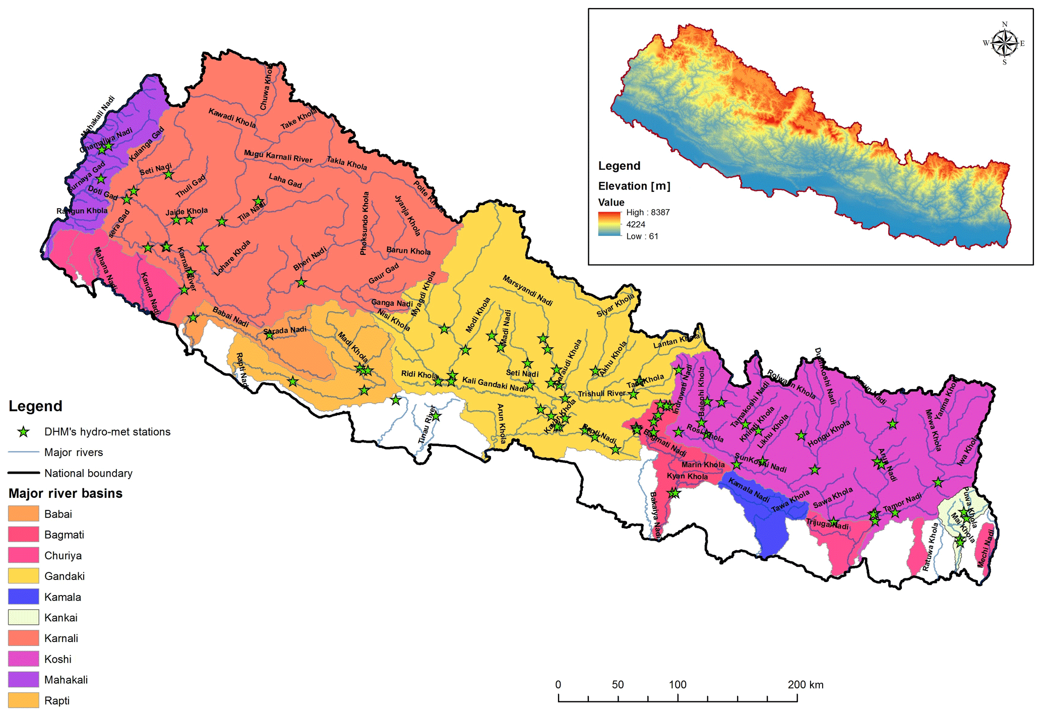
Figure 1Map of Nepal showing main rivers, locations of DHM-owned river gauges, and river catchments.
Nepal has three distinct types of rivers: (i) big perennial rivers, e.g. the Koshi River, the Narayani River, the Karnali River, and the Mahakali River – these rivers are mostly fed by the glaciers and snowmelt in the Himalayas and flow down to India through the lower hills and Terai plains of Nepal; (ii) perennial rivers fed by rainfall, originating from the middle mountains of Nepal that flow down to the lower plains of Nepal and India – these kinds of rivers flow with very high variation between the dry and rainy seasons; (iii) torrents or streams – these rivers originate from the Siwalik hills and are fed by the monsoon rains from June to September, drying up after the rainy season (Bhandari et al., 2018). Monitoring stations are located on the first two types of rivers (Fig. 1).
Flash floods in small intermittent streams have become an increasing concern in recent years with an increase in the occurrence of these destructive flash floods that carry lots of debris, raise river bed levels, and breach into settlements (Bhandari et al., 2018). Most of these streams do not currently have government-owned monitoring stations, although there are some initiatives to set up community-managed monitoring stations on these streams (e.g. International Centre for Integrated Mountain Development (ICIMOD) and Mercy Corps).
3.1 Established EWS
Nepal's EWS has developed from a simple “watch and warn” approach (e.g. using raised towers, sirens, and traffic light signals) to an automated telemetry system (Fig. 2) which gives from as little as 30 min to as many as 6 h of warning, depending on distance from the gauge reader (Practical Action, 2016).
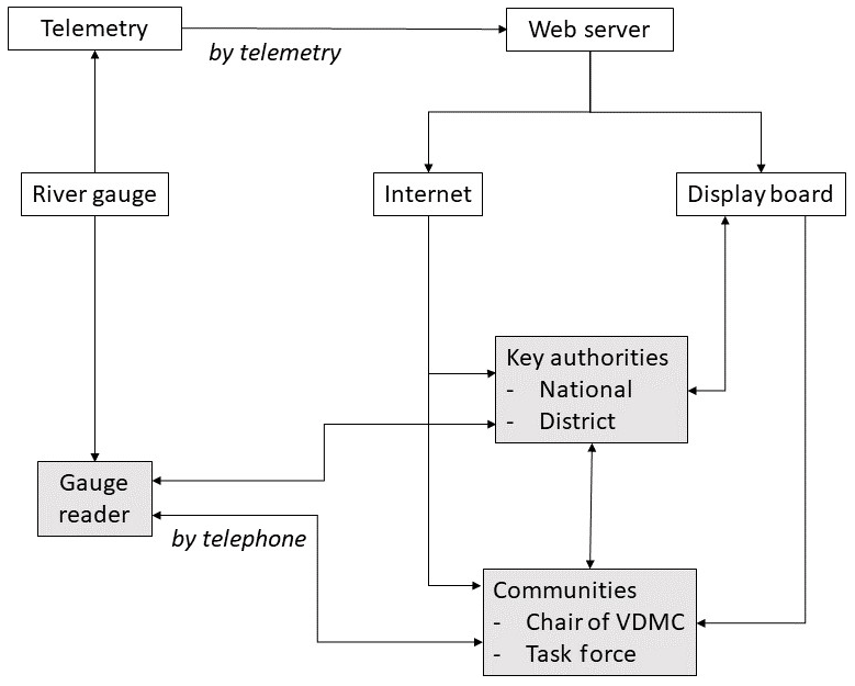
Figure 2Early warning communication chain including telemetry system and actors (in grey) (from Practical Action, 2016).
A telemetry-based early warning system is the main EWS in operation, based on real-time monitoring of water level and rainfall at the upstream catchment of flood-prone areas (Fig. 2). This simple EWS provides a short lead time of 30 min to 6 h based on the travel time of the flood wave from the monitoring station to the location of villages and community members. These monitoring stations are located on main rivers (Fig. 1). If the river level passes the threshold of danger level upstream, national and district authorities and key community members are alerted (Fig. 2).
The basic EWS relies on real-time monitoring of river data, through a combination of manual river gauge reading and automated river gauges. Redundancy has been an important element of the EWS, ensuring that if one channel for river monitoring (or dissemination) fails, there are other options (ISET et al., 2015). When water levels upstream exceed pre-determined danger thresholds, a warning is triggered, which is communicated through a variety of top-down and bottom-up mechanisms (Figs. 2 and 3). Digital and top-down communication includes digital display boards in district authority buildings, internet-based alerts and updates, and automatically triggered alarms at sub-national government level, each of which triggers pre-determined dissemination and response protocols. Bottom-up community-led dissemination includes telephone-based dissemination from gauge readers to local community responders, triggering in-person and community level alarms and alerts, e.g. via loudspeaker (Practical Action, 2016; Smith et al., 2017).
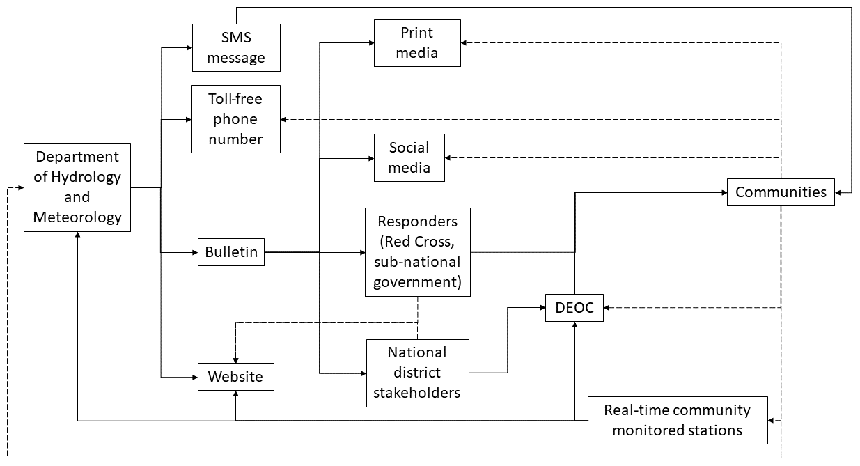
Figure 3Flows of forecast and early warning information in Nepal as of 2017 monsoon. Solid lines indicate actively “pushed” information; dashed lines indicate accessible “pulled” information.
Nepal has a variety of community-managed early warning systems, depending largely on manual gauge readers. ICIMOD, Mercy Corps, Practical Action, and other NGOs have helped install monitoring instrumentation in basins not (yet) covered by the national monitoring network, including in some of the small flash-flood-prone basins like Ratu Khola (Practical Action, 2016). At community level, volunteer gauge readers (“caretakers”) monitor river levels, passing manual readings to the Department of Hydrology and Meteorology (DHM) and local community members. These systems provide varying lead times of warning (1–6 h), with three levels: be careful; warning; danger. NGOs have helped build community response capability for early warning and early action across several river basins in Nepal. They have worked with communities to establish EWS task forces at community level, set up local disaster management institutions, and undertake evacuation drills, practicing response to early warnings (Smith et al., 2017).
National early warnings are issued by the Flood Forecasting Section of the Nepal DHM, the government agency formally mandated to issue early warnings (a team of about four people as of the 2017 monsoon). The Flood Forecasting Section of the DHM has an openly accessible website (http://www.hydrology.gov.np, last access: January 2020) containing real-time river and rainfall gauge data and flood forecasts, showing which river levels are rising or falling, and what their current warning level is (below warning, above warning, above danger level). A toll-free helpline (1155) is available for anyone to call to the DHM to ask for updates or information on flood risk. However, this number is not advertised widely due to limited capacity to deal with incoming queries. The number goes directly to two mobile phones owned by DHM and is answered by the small DHM team.
3.2 Recent innovations
In recent years, the EWS in Nepal has undergone rapid development, with a range of innovative pilot schemes introduced in the 2016, 2017, and 2018 monsoons (Fig. 4). These new initiatives have brought (a) innovations in forecasting; (b) innovations in dissemination; and (c) innovations in response capability (decision-making and pre-event plans).
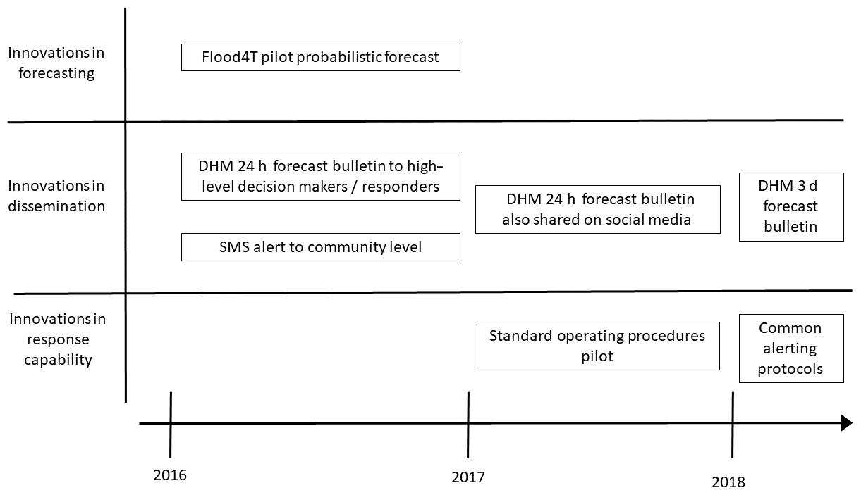
Many of these innovations have aimed to increase the lead time of early warnings, aiming to improve early action and reduce avoidable losses. For high-level decision makers such as the DHM and responders, increased lead time enables earlier warning and better preparedness for response. At community level, increased lead time enables more time for evacuation and protection of property and livelihoods, particularly important in cases where warnings are issued when people are working in the field, or during the night (Practical Action, 2016). A gender dimension is noted in Nepal, with vulnerable groups, often including women, expressing a desire for increased early warning lead time (Brown et al., 2019).
3.2.1 Innovations in forecasting
Global and regional hydrological and meteorological forecasts
Improvements in global and regional forecasting (both hydrological and meteorological) have increased the amount of information available for EWSs in Nepal. The DHM has been piloting application of a range of forecasts to enhance the flood early warning system in Nepal. These include the Global Flood Awareness System (GloFAS) developed by the European Commission and the European Centre for Medium-Range Weather Forecasts (ECMWF), which provides a 10 d rainfall forecast and a 15 d streamflow prediction (Fig. 5). The Regional Integrated Multi-Hazard Early Warning System (RIMES) for Asia and Africa provides three-day rainfall forecasts and three-day streamflow forecasts for three basins in Nepal updated daily (Fig. 5) (Uprety, 2018). The DHM is also in the process of developing their own three day meteorological forecast.
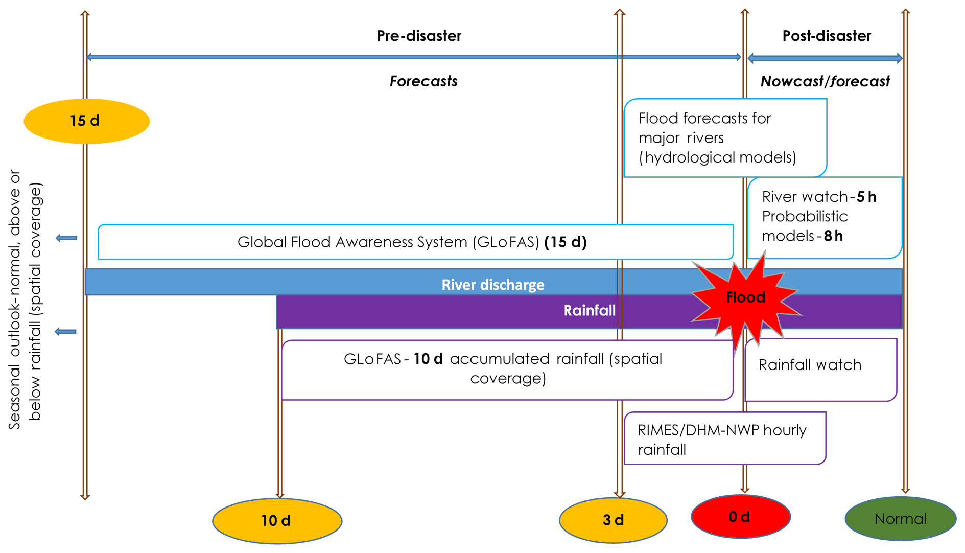
Figure 5Diagram of lead time of forecasts in Nepal. Pre-flood event forecasts provide 15, 10 and 3 d forecasts, with shorter term river level forecasts providing 5–8 h of early warning.
Low data probabilistic flood forecasting (Flood4T)
The DHM has been piloting a low data probabilistic approach to flood forecasting in partnership with Practical Action, Lancaster University, Waternumbers, and Zurich Insurance (Fig. 6). This has now been rolled out across major and minor river basins in Nepal, extending available lead time by up to an additional 5 h. These increased lead times for early warning and early action can be critical in fast-flowing mountainous rivers (Smith et al., 2017).
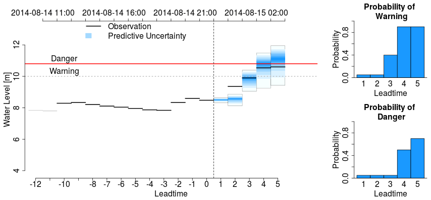
Figure 6Flood4T enhanced probabilistic flood forecast issued at 23:00 (local time) 14 August 2014. Panel (a) shows predictions of future water level (blue) for the next 5 h (observed levels at each time are shown in black). Panels (b) and (c) show the probability of crossing the respective warning levels in the next 5 h. Source: Smith et al. (2017).
3.2.2 Innovations in dissemination
In recent years, the DHM has been piloting an expanded range of methods for centralised top-down dissemination of early warning, including bulletins and mass SMS message dissemination to the general public (Practical Action, 2016).
A daily bulletin (see http://www.hydrology.gov.np) containing text-based information on flood hazards, highlighting river basins and districts at high risk of flooding, is produced in Nepali and sent via email to selected national, sub-national, and district level stakeholders (Fig. 3). These stakeholders include the Minister of Water Resources, Energy and Irrigation, Nepal police, National Emergency Operation Centre (NEOC), DHM regional and basin offices, Joint Secretary of Ministry of Home Affairs (MOHA), Director General of DHM, ICIMOD, Practical Action, Nepal Red Cross Society (NRCS), World Food Programme, Lutheran World Relief, United Nations Development Programme, Society of Hydrologist and Meteorologist, Water and Energy Commission Secretariat, Department For International Development, and to personnel in the flood forecasting section of the DHM. Since 2017, the bulletin is also being shared through the DHM website (http://www.hydrology.gov.np), Twitter (Nepal Flood Alert), and Facebook (Nepal Flood Alert).
Flood-prone areas across Nepal have been divided into 42 polygons (spatial units). When an area is at risk of flooding, the DHM is able to send targeted mass SMS messages via telecom providers to the mobile phones within that polygon (Fig. 3). These alerts are simple: “be alert”; “prepare to evacuate”; “evacuate now”. These warning messages are currently based on the simple real-time water level monitoring-based EWSs (with relatively low lead times – see previous section). There is currently no standardised language for the SMS message; messages can be in Nepali, English, or romanised Nepali. Each SMS (as of the 2017 monsoon) is written by the DHM Flood Forecasting Section manually and sent to telecom providers to send out SMS push messages (Sumit Dugar, personal communication, July 2017).
Prior to 2018, messaging for DHM bulletins and SMS alerts were crafted individually, as needed, by staff in the Flood Forecasting Section of the DHM. In order to automate the overall process of early warning dissemination, DHM piloted the common alerting protocol (CAP) in the 2018 monsoon with technical support from Practical Action. This will ultimately help to standardise the content of bulletins and SMS alerts and target them to stakeholders at all levels, including vulnerable communities, effectively and efficiently. As the availability of more complex forecasts increases, questions remain about the extent to which it would be appropriate to communicate uncertainty, or probability, to non-technical community level actors, an issue to be further explored in Nepal.
3.2.3 Innovations in response capability (decision-making and pre-event plans)
In the past couple of years the EWS in Nepal has evolved to better support pre-event decision-making and planning, helping decision makers understand and act upon more sophisticated and complex forecasts through decision support tools, such as standard operating procedures.
Standard operating procedures (SOPs) outline preparedness and early action protocols in response to weather and flood forecasts to help decision makers improve early action, protecting lives and livelihoods and reducing the human and economic costs of post-disaster response (IFRC, 2016). With support from the German Federal Foreign Office, the World Food Program (WFP) in Nepal is piloting Forecast Based Flood Preparedness (FBFP) in six districts of the mid- and far-western Terai in collaboration and partnership with the DHM, the NEOC, Practical Action, and ICIMOD (Uprety et al., 2018). In 2017, the FBFP pilot developed SOPs, working collaboratively with a range of stakeholders (humanitarian responders, the DHM, and community members). The SOPs were selected to correspond to a range of forecasts at different temporal stages in the lead-up to a flood event, identifying thresholds and triggers for specific early actions to be assigned to specific actors in a responsibility matrix. These SOPs were implemented in six flood-prone districts of West Nepal during the 2017 monsoon.
The scale and extent of flooding during the 2017 monsoon in Nepal was unusual and extensive; more than 41 000 houses were destroyed completely and another 151 000 were partially damaged across the country, displacing tens of thousands of people (Bhandari et al., 2018). Anecdotal evidence after the monsoon suggested the early warning systems on the major river basins saved numerous lives during the 2017 flood – despite the devastation only 12 lives were lost; in addition, the flooding was accurately predicted more than 10 d in advance by global flood and weather forecasts (Bhandari et al., 2018). However, there also appeared to be a gap between the information available and the early action taken on the ground (this was later supported by post-event analysis conducted by Bhandari et al., 2018, published after the data collection period for this paper).
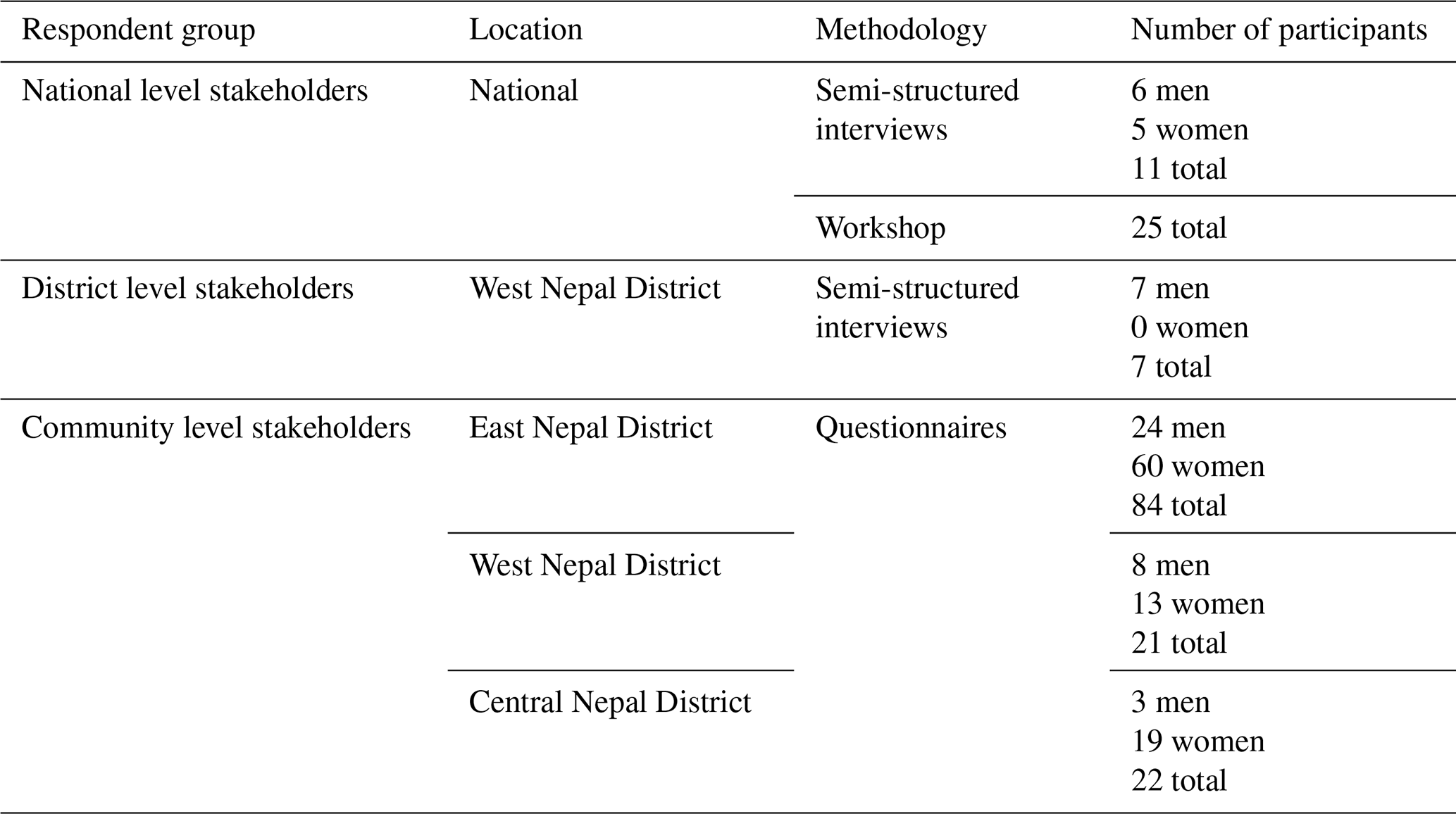
As such, research was undertaken after the 2017 monsoon to analyse how the early warning systems in Nepal operate, how well they incorporate complex forecasts, which stakeholders have access to (and understanding of) complex forecasts, and whether incorporation of more sophisticated forecasts (and uncertainties) enables improved early warning and early action. Data collection is summarised in Table 1.
Table 1Summary of participants and data collection methodology.
Qualitative data analysis throughout was conducted using the same codes, which emerged from the dataset itself. The data were coded in two stages, with an initial stage to identify codes across the dataset and then a subsequent recoding using the finalised codes. The final analyses are organised below by scale, focussing first on national-level, then sub-national level, and then community level.
4.1 Ethics
This study is based on key informant interviews (KIIs), a workshop held in Kathmandu, and a community questionnaire. This research involved community members, government officials, and representatives of non-governmental and civil society organisations. All participants were asked for their consent to participate in the research. Data were anonymised (community members) and pseudonymised (high-level or key informant stakeholders) and handled under the General Data Protection Regulation 2018. An ethical review was carried out for this research at King's College London.
4.2 National-level stakeholders
Semi-structured interviews were conducted with 11 national key stakeholders (six men, five women) from six organisations who disseminate or receive early warning information from the DHM. The interviews were framed around their experiences during the 2016–2017 monsoons to gauge their understanding of the early warning information, if and how they used the information, what decisions were made based on the information, and whether they communicated the information further. In particular, questions were aimed at how recent progressions in the EWSs had affected their understanding and ability to make decisions, including the piloting of the Flood4T probabilistic forecasts and SOPs. Feedback on successful progress and remaining challenges were gathered. Information on what additional facilitation or processes would be needed to communicate probabilistic information at community level effectively was also investigated. Sampling was purposive: interviewees were selected because of their role.
A national level workshop was held with 25 key stakeholders from 12 organisations, including the DHM, on the EWS and probabilistic communication in January 2018. The workshop was aimed at identifying any lessons learned or best practices for communicating forecast uncertainty in order to help share the gathered evidence to improve forecasting and EWSs in the future. Reflections and discussion points were recorded and later coded for analysis.
4.3 Key informant interviews at district level
Semi-structured interviews with seven key stakeholders in Nepal were conducted in the Bardiya District in West Nepal. The interviews were held with NGOs, District Emergency Operation Centres (DEOCs), and district DHM officers who receive DHM issued warnings or information. Again, the sampling was purposive. Interview data, which consisted of notes from the interviews, were coded thematically for analysis using simple codes that emerged from the data. The KIIs covered responses to specific types of warning information and also discussed the informants' perceptions of community awareness.
Respondents were from the local DHM office (1), DEOCs (2), and local NGOs (4). All of them were male, and all had been working in their current sector for more than a year: two for 5 to 15 years and two for more than 15 years. Their education levels varied from beyond high school to masters graduate level, and they ranged in age from 20 to 60.
4.4 Community level
Answers to qualitative and quantitative questionnaires were collected by research assistants using random sampling from 127 individuals at community level in East (Jhapa District), West (Bardiya and Kailali Districts), and Central (Nawalparasi District) Nepal. The questionnaires were designed to gather information on each participant's understanding of early warning messages and probabilistic information. The data were analysed using standard statistical tests. They were initially tested for normality using the Kolmogorov–Smirnov test. Most of the data were not normally distributed, and so non-parametric tests were used in the analysis. For categorical data, the chi-square test was used to test for differences by group. Ordinal and scalar data were analysed using the Mann–Whitney U test for differences between two groups, and the Kruskal–Wallis H non-parametric analysis of difference for more than two groups. Correlations were assessed using Spearman's correlation coefficient.
At community level there were 22 respondents in the central region, 21 in the western region, and 84 in the eastern region. The gender breakdown is not significantly different between the regions (χ2 not significant), and 92 of the 127 interviewees were women. The age distribution in the western region is skewed towards younger ages (21–30) while the other two regions both have modal values in the range 31–40. Most respondents live in kutcha (temporary mud) housing. In the central region, three respondents were in pucca (brick and cement) housing, and in the eastern region, 24 were in pucca housing. There were also small variations in household size between regions, with smaller households in the central region than in the other two regions. Over the whole dataset, there was a normal distribution with a mode at five to seven household members. Over the whole dataset, 74 % of respondents were members of community groups. Just over half (53 %) said that the male head of household migrates for work, and of these, 90 % migrate outside of Nepal.
In total, 94 % of community level respondents either owned a mobile phone themselves (54 %) or had one in their household (47 % of the latter said their spouses owned a phone). Disability affected 21 % of respondents. Education levels within the households were relatively low, with only 20 % having education beyond secondary school, and 34 % having only primary school education.
5.1 Findings relating to national level stakeholders
5.1.1 Complex forecasts
At national level there was strong support for the overall availability of flood forecast information, and a willingness to work with the DHM to improve it.
Representatives from the DHM described the tools that are being developed using both global (GloFAS) and regional (RIMES) systems, with catchment-based approaches. They also noted that numerical weather prediction based on global data is weak – it does not accurately predict the location or magnitude of the rainfall or river levels. NGO representatives were also sceptical about the magnitude of the predictions. Members of the local DHM office were not entirely sure how to use these tools, and would value training in this.
National stakeholders wanted the forecast to be categorised by impact – using probabilistic forecasts to provide warnings about impacts on livelihoods and assets and for preparedness, and deterministic forecasts to drive evacuation plans (except for in flash floods, where probabilistic forecasts are useful because they give more lead time).
5.1.2 Enhanced dissemination: DHM bulletin
The DHM 24 h forecast bulletin was widely regarded by other national stakeholders as important – and there were comments that it should be available at both district and community levels (via radio) as well as among existing recipients, and broadcasts increased to hourly intervals. In particular, the flood risk matrix and likelihoods (Fig. 7) had significant potential, particularly if they are developed as part of a “risk-based approach” (representative, UNDP).

Figure 7The flood risk matrix that is used across England, Scotland, and Wales to communicate the likelihood and potential impacts of flooding. Source: Flood Forecasting Centre.
Another suggestion involved including spatial information in the bulletin – again with a caveat about understanding of this information (which is backed up in the literature – e.g. Haynes et al., 2007). Various types of information that could be included were suggested (e.g. probability of ranges, percentage changes of event occurring, small area forecasts).
UNDP also made the point that historical data – particularly observational data – would be useful and would enable the development of decision-support tools, which are currently lacking. Some of this might be complicated by institutional staff turnover and capacity at the DHM in general. However, the DHM were praised for their use of social media.
National stakeholders also suggested that using colour codes and ranges of probabilities might simplify the forecast (see Fig. 7). They were aware of various tools in the public domain but felt that these are not adequately advertised: “NWP three-day forecast is out in the public domain; but few know how to get this” (Representative, LWR).
5.1.3 Communicating uncertainty to a high-level audience
The national stakeholders identified a number of high-level audiences who would benefit from extending the bulletin to include uncertainty information, including the hydro-meteorological community and government agencies (at various levels and in various fields). NGOs would also value this information, as would businesses.
National stakeholders suggested that the uncertainty could be communicated via spatial and temporal risk maps and using a simple matrix. It would be useful to have numerical values of both probabilities and uncertainties, as well as the area affected, at an hourly scale.
5.1.4 Communicating uncertainty in the forecasts to the public
While communication to the public was supported, particularly to inform certain industries, there were a wide range of opinions amongst national stakeholders on the suitability of different kinds of information for public consumption. These largely reflected different views about the education level that people have (or could be given via outreach campaigns). In general, the stakeholders felt that a major campaign of engagement with community members would be needed to help people both understand the information and act on it – again, the issue of acting on warnings was emphasised.
The national stakeholders were generally unsure about the ability of the public to understand probabilistic forecasts. They suggested that perhaps the system could be supplemented by voice messages that give probabilities, but were concerned about these being misinterpreted if trialled too soon.
There were differences of opinion too amongst national stakeholders on whether or not certain groups should receive the uncertainty information. Some respondents did not think that the media or the community should be informed, while others felt that, with education, they could be.
Communicate forecast uncertainty only if you can convince; then otherwise it is better not to communicate as it will lead to a false message. (Forecaster, DHM)
This quotation betrays a lack of confidence in the reliability of weather and flood forecasts and subsequent concern about false alarms and the breakdown of trust.
A representative from the army made the interesting point that government information (i.e. from an “official” source) may be viewed as more reliable and perhaps therefore more likely to be acted upon locally:
Need to provide information to local level as a forecast as early as possible; need to use latest technology tool from government level, because government information is more reliable for local community. (Representative, Nepal Army)
This point was backed up by LWR in the stakeholder interviews: information from the government is viewed as genuine. This could be important in thinking about integration with community-managed EWSs. Furthermore, some stakeholders were concerned that DHM were too conservative in their attitude to communicating with community members – particularly that they were reluctant to communicate uncertainties.
In general, the national workshops suggested that community members should be reached by SMS only for high-probability events, with messages in local languages. Simple or interactive voice messages would be useful, to support information available on websites, TV, and radio. This multi-media approach is likely to maximise the reach of the message. There was a major emphasis on training for community members so that they know what the messages mean and how they should respond to them.
5.1.5 Understanding community members
Throughout the national stakeholder interviews and workshop, there were various assumptions about how people view the risk:
Vulnerable (people) only believe what they see – we need to educate them. (LWR)
It is difficult for them (public) to decide based on probabilistic information, we need to be more specific. (DHM)
People don't have an idea of uncertainty; we have to train people (what actions to take) under certain range of certainties. (UNWFP)
There is a difficulty in using technical jargon; the citizen does not get this, and we cannot translate. (BBC Media Action)
Overall, these quotations and other comments in the dataset suggest a widespread concern among national stakeholders for training and education on several topics. One of these topics would be appreciating uncertainty and probability, and perhaps linking this directly to what actions should be taken at different levels of uncertainty or risk. Another would be emphasising that the forecasts go beyond experience or measurement and give scenarios about the future, so they should not wait until they can see physical evidence of their accuracy. From these statements, too, it is evident that this “education” should not be top-down but must involve listening to and working with the community members and intermediaries to translate information – which would also help the producers of information to move beyond technical jargon.
You have to be very honest and promote discussion in the community, to help them prepare themselves. (Representative, BBC Media Action)
5.1.6 Common alerting protocols
National stakeholders also emphasised the need for a common alerting protocol (CAP). This would provide consistency in terminology or colour codes for the warning and for communicating uncertainty.
5.2 Findings relating to sub-national stakeholders
5.2.1 Complex forecasts at sub-national level
Respondents at district level were all familiar with GloFAS probabilistic rainfall forecasts but do not currently receive them. Three out of the seven access the forecasts via the website. They struggle to understand the colour coding system, and one noted that they have issues with the geographical focus. Two mentioned understanding probabilities as an issue. Three of them mentioned using the forecasts to find out where it will rain. They felt it could be made more useful for them, and felt that the resolution was not very good for small-scale use. They also felt that it should be in Nepali. There was a strong call for training in how to use the information. None of the respondents had used the forecasts for making decisions.
District level respondents rated their understanding between 3 (two respondents) and 7 out of 10. There was a reasonable positive correlation here with level of education, though with only seven interviews this should be viewed with caution (R2=0.7).
Respondents at district level noted that they had seen GloFAS probabilistic flood warnings but had not been receiving it. Most of them could find it on the website, but they struggled to understand it. Two noted specifically that they found return periods hard to understand, and another two listed the figures in their entirety: “We are not technical people, so all of it”. Two did state that looking at the probability of floods was useful, and they appreciated the map format. Five felt it could be made more useful, and one that it might be able to be made more useful. None of them used the information in making decisions. They had been told about the forecasts in the SOP workshops, but they would like training in its use.
The self-assessment of understanding produced some interesting results for this set of figures. The assessment correlated negatively with age – the younger respondents at district level found it easier to understand (R2=0.5). Here, the highest rating was 6 out of 10, with the other six respondents scoring their understanding 2 to 4 out of 10.
All the respondents at district level were familiar with the RIMES 3 d rainfall forecasts, and six of them regularly receive it by email. They suggested that the colour bar could be improved and extended for extreme values. Two also mentioned that the resolution was poor, and one stated that real-time information is more useful. One also mentioned that it would be helpful if it was in Nepali time rather than Coordinated Universal Time. In general, they use the map to identify high intensity rainfall areas but would like it to be improved – both by improving the scale and by issuing it every 3 h rather than every 24 h. The spatial scale was the most emphasised issue with the forecast, although a need for training was also mentioned.
Four respondents at district level noted that they use this information frequently in decision-making, and the other three use it “sometimes”. They use it to warn stakeholders in the affected areas that there may be heavy rain in the next few days. Two also warn community members where they judge it appropriate. If they detect heavy, intense rainfall in their region, then they would take action. Two specifically noted that they would use this alongside the DHM bulletin, because this information is only a forecast. Another noted that “We just share based upon our interpretation but don't know if it's right or wrong” (local NGO).
All the respondents at district level rated their understanding of the RIMES forecasts at six or more, suggesting a reasonable level of confidence in using the information. There were no patterns with the demographic variables.
Five respondents at district level had seen information on short-term probabilistic early warning before (on a website), and two receive it regularly, but none use it for decision-making. They find the uncertainty band difficult to understand. They use it to assess what will happen in the next 3–5 h in relation to what has recently happened.
The respondents at district level mentioned that it would help to have some textual explanation of the figure – perhaps some simplified text. One mentioned that this was too technical for community use, and another stated that DHM prefers to use this information internally. Understanding was rated at 5 (three respondents) and 7 (one respondent – the most educated) out of 10.
5.2.2 Role of DHM bulletin
ICIMOD (a regional NGO) mentioned that their community-managed EWSs also share the DHM bulletin with some of their caretakers, which adds to community knowledge.
At district level, six of the respondents receive the bulletin twice daily during the monsoon, and the seventh used the DHM website instead of the bulletin. They only experienced difficulties accessing the bulletin when an internet outage occurred. All except one use this information to make decisions, and two specified that this would involve communicating with local offices. Most of them used the bulletin to identify rainfall and river information in real time, particularly looking for rivers in their vicinity – so looking for spatial features in the data. One commented that they struggled to find the spatial information easily, and others mentioned that some quantitative rainfall data would be useful. They were uncertain about how to interpret “low, medium, and high” levels of rainfall, and suggested that rough ranges for these categories should be given. One said the following:
We do not know the contribution of rainfall to river water, how much it rains and when river rises, it's all based upon judgement. We need scientific information in easy accessible format to understand this such that we know what is happening upstream and link to downstream. (Local NGO)
When taking decisions, the respondents at district level stated that they use the bulletin to look at how much rainfall there is, either using thresholds or looking at the general pattern over their particular area. They find the bulletin a significant aid in the decision-making process, and communicate it widely when their thresholds are reached, telling their respondents (other stakeholder or the public, depending on circumstances) the status of the rainfall and rivers. Four of them mentioned simplifying the information for the community level, and they use a full range of communication methods between them (social media, email, SMS, telephone).
In seeking to improve the bulletin, respondents at district level would like infographics and 24 h spatial and temporal information. They would also like better spatialised forecasts for local areas with more specificity – for example, by district rather than just “East, West, Central” – and indications of whether rivers are rising or falling, preferably at basin level and also for the flash-flood areas. All of the respondents were keen to work with the DHM to improve the bulletin and its communication. Two of them emphasised the importance of national-level DHM working with the local-level DHM offices.
In self-assessing their understanding of the bulletin, most respondents at district level said that they had a reasonable understanding (6 or 7 out of 10). One said 8 out of 10 and another 9 out of 10. There were no obvious patterns here (in relation to demographics of the respondents).
5.2.3 Standard operating procedures
The SOPs were trialled in the 2017 monsoon season for the first time. Only two respondents at district level had used the SOPs to take action in advance of and in response to a flood. Prior to the introduction of SOPs, six respondents reported they used DHM bulletins, and four used both DHM and RIMES for early preparedness actions and emergency response. However, these actions were not as intensive and elaborative as those defined in the piloted SOPs.
The district stakeholders are now accessing more forecast information from different sources since the introduction of SOPs, but they still regard the DHM bulletin as the most authentic one for informing action.
Respondents at district level commented that they struggle to make the forecasts actionable, and some also struggled with probability. Two of them noted that the responsibility matrix is particularly useful. They use the documents particularly to find out who is responsible for what but also noted that the procedures are evolving and long, and hard to get used to. They would like the SOPs to be adaptive, and short. It would also be useful to empower the local actors, such as local NGOs, CBOs, village committees, and households, to take action: this issue was raised several times because there was a feeling that local actors lack the resources to use the SOPs effectively.
Two respondents at district level said that they sometimes use the SOPs in decision-making, but that they need more time to better understand the SOPs. One said it has been integrated into their District Preparedness and Response Plans (DPRP). The respondents generally felt that the SOPs need more time to be properly understood and integrated. One suggested that the thresholds should be changed, based on the 2017 experience – this fits with the need to make the SOPs adaptive to circumstances. They also suggested, again, the need for training in understanding the forecasts and emphasised that accurate forecasts would be useful:
DHM needs to provide regular forecasts with longer lead time and accuracy but we need training to understand probabilities and uncertainties. (District level NGO)
There was also emphasis on the need for time for community members to get sensitised to this information:
Yes we can use it but people won't evacuate three days earlier. For them it must be raining and river water must enter their community; only then will they evacuate. So SOP is good but change in thinking of people will take time. (DEOC/local NGO)
This last point is interesting: it suggests that the long-term mentality of flood risk management in Nepal is reactive and focussed on real-time event evolution. The availability of forecasts is relatively new, and incorporating this information in local actions will take a culture shift.
Understanding of the SOPs was rated between 4 and 6 out of 10 (five respondents assessed their understanding as 6, and the others 5 and 4). This perhaps represents the novelty of the concept, the length of the document and the fact that it is still evolving – all factors mentioned by respondents.
There was also a comment that the available information is not problematic in itself, but the “flow of information” (for example, in the 2017 monsoon) was unreliable in spite of piloted SOPs.
5.2.4 Communicating uncertainty in the forecasts to the public
Stakeholders representing NGOs had different views regarding the communication of uncertainty to the public, and were more in favour of this approach.
Please provide efficient, understandable and accurate information of flood and rainfall (during peak monsoon) to the community through electronic media (especially radio) on very regular (3-hourly intervals) of time. (Representative, Lutheran World Relief)
User-specific information; multiple channels of communication need to be deployed; people centric. (Representative, ICIMOD)
Forecast uncertainties message should be communicated through different media along with forecast information, but it should be in easily understandable term/words/languages to everybody. (Representative, UN WFP)
This suggests, perhaps, that NGO practitioners were particularly interested in empowering the public to understand the forecasts:
Use maximum number of available options to make forecast information and to educate all stakeholders and recipients; Use risk matrix approach to communicate the uncertainties. (Representative, Practical Action)
For effective response, the forecast uncertainties should be communicated giving the probabilistic figure (in % uncertainty) but together with this information, the community members should be given awareness programmes to act/react to this information in an understandable way and timely manner. (Representative, ICIMOD)
However, the stakeholder interviews also cautioned against excessive communication of uncertainty as well. Representatives from ICIMOD, for example, suggested that “Communicating uncertainties is not necessarily important and useful at the community level”. They also suggested that perhaps probabilities are better than actual levels, expressing some scepticism with the quality of predictions from GloFAS. This balance issue between communicating uncertainty and the fear of false alarms or misunderstandings is consistent with the anxieties of scientists in other related fields, where uncertainty is sometimes perceived as undermining science (Eiser et al., 2012).
Another important point was that, as well as giving information about probabilities, information about actions to be taken is important:
While issuing flood forecast, it is better to issue forecast water level along with uncertainty range and action to be taken considering the flood level and its uncertainty. (Representative, PAC)
The BBC Media Action team emphasised that they could aid the communication of flood warnings more widely, and that a key aspect of this could be the provision of a “dashboard” of material ready for communication. This would link to the CAPs being developed for piloting in the 2018 monsoon, and alerts could be sent to journalists with adequate lead time. They also emphasised that the information should be “factual, i.e. what you can do, what is the best shelter, what elevation you can go to”.
5.3 Findings relating to community level stakeholders
5.3.1 Community access to and understanding of SMS early warnings
Community level respondents were asked if they had seen the SMS text message warnings before – 33 % had done, most of them directly (note that 56 % did not answer this question) (see Fig. 8). Of those who were asked (N=46), 40 % found the SMS very hard to understand, and 57 % rated their understanding as 5 out of 10 or less (Fig. 9). However, 30 % thought it was very easy to understand.
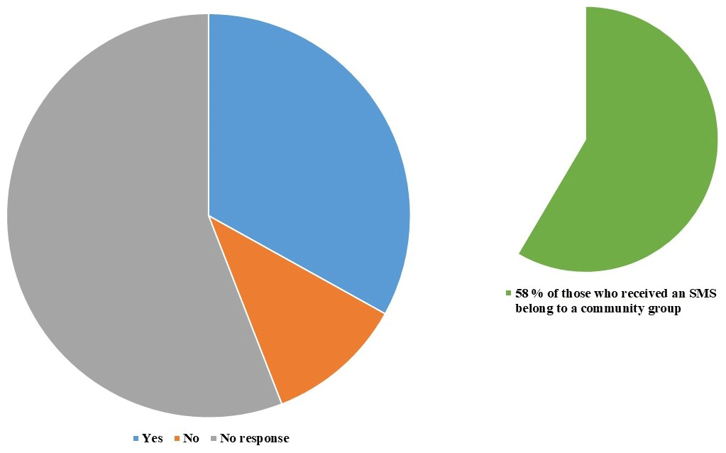
Figure 8Percentage of community participants who have received an SMS text message warning; 58 % of those who responded “yes” belong to a community group.

Figure 9Number of responses to the question: “On a scale of 1–10, how well do you understand the warning”, divided by gender. Responses closer to 10 indicate better understanding.
A local representative of Lutheran World Relief mentioned relying on DHM's SMS system (in addition to the bulletin) but noted that there are some issues with the reliability of the mobile phones in practice.
Looking in more detail at the dataset, some patterns emerge.
The community level respondents who were members of community groups were more likely to have seen the warning (χ2=10.6, p<0.01) (Fig. 8). People from the Dalit ethnic group and associated lower socio-economic status were much less likely to have received it at all.
Men were significantly more likely to understand the message well (U=99.5, p<0.01) (Fig. 9). Older people were significantly less likely to understand the message well (, p<0.05).
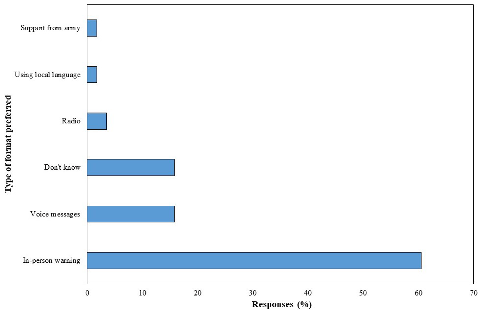
In general, most community level respondents would like the information to be presented differently (52 %), and 61 % would prefer an in-person warning (Fig. 10). A further 17 % would have liked a voice message. This is consistent with low levels of literacy and a strongly cohesive community in which the personal source of communication is important.
5.3.2 Community responses to SMS early warning
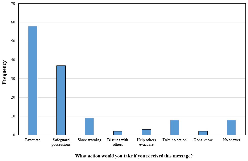
Community level respondents were also asked about their likely actions on receiving a SMS push warning notification message. Figure 11 shows that while most would evacuate, a significant number would not. Indeed, when asked for the likelihood of taking these actions, 46 % said that they would be very unlikely to act, and only 21 % said that they would be very likely to act. When probed further, 56 % said that it would be very hard for them to act. Several reasons were given for this, the most prominent being illiteracy (27 %) and difficulty making decisions (16 %).
There were significant differences by region in whether or not people were willing and able to act on receiving an SMS. People in the eastern region were significantly less likely to act (H=11.4, p<0.01) and felt that it would be harder to act (H=17.3, p<0.001) (Fig. 12). There was also some variability in ability to act that could be explained by ethnicity, with Dalit and Janajati ethnic groups particularly unlikely to be able to act (H=12.3, p<0.05). Older people were less likely to act (, p<0.05) and less able to act (, p<0.001).

Figure 12Likelihood of taking action based on warning message on a scale of 1–10, divided by district; responses closer to 10 indicate greater likelihood of action.
Finally, both central and western regions would prefer the information to be presented differently and in voice message format, while more people in the east were happy with the format, but those who sought improvements tended to favour in-person warning.
6.1 Nepal's EWS: gaps and challenges
Recent developments in weather and flood forecasting have increased the availability of information relevant to the flood early warning system in Nepal. However, whilst the quantity and quality of information has increased, it is apparent that not all stakeholders are aware of, have access to, understand or act on this information. This section will review the Nepal EWS in terms of the four core and three cross-cutting elements of an EWS.
6.1.1 Risk knowledge
There is substantial awareness at national and district level of the bulletin as a source of information. There still remain barriers to national and district level stakeholders using the wide variety of forecast information available in the public domain, including a lack of awareness of the information, and difficulty understanding and interpreting the technical information for decision-making. However, the focus should be on improving the bulletin to help these non-technical decision makers to better understand and take action, rather than prioritising significant investment in improving their understanding of the range of forecast and supplementary information available.
The differences in community perceptions and requests for improvement of warning information between study sites is likely to reflect people's understanding, knowledge, and familiarity with the early warning system. For example, community respondents in the east are less familiar and experienced with the more recent system and less knowledgeable about the potential improvement options available to them; they are mostly happy with the warning format, would prefer more in-person communication, and are less likely to react to warning. In comparison, the flood early warning system in the West and Central Nepal study sites are well established and community respondents have a longer history of receiving early warnings. As a result, their responses reflect more appropriate reactions to receiving warnings and more critical assessment of the type and format of messaging, requesting more innovative forms of messaging and more clarity in the content.
6.1.2 Monitoring and warning
In terms of monitoring and warning, challenges remain related to (i) improving forecasting accuracy, (ii) improving monitoring, (iii) improving lead time, and (iv) introducing impact-based forecasts.
There needs to be improvements in the spatial resolution and magnitude accuracy of both meteorological and hydrological forecasts in order to be able improve early warning and early action.
EWS accuracy in smaller rivers is constrained by a lack of monitoring stations on intermittent smaller rivers. Community members based on those rivers are therefore not able to take early actions to save lives and livelihoods. Challenges relate to a lack of monitoring stations, a lack of investment in monitoring infrastructure, and a lack of maintenance of instrumentation purchased by multiple actors for multiple short-term projects.
Innovations such as low data probabilistic forecasting (Flood4T) offer an opportunity to increase early warning lead time beyond the timeframe permitted through warning systems based on real-time monitoring of water levels upstream. Flood events in 2013 and 2014 have shown that the available lead time provided by water level monitoring-based systems is just enough to save lives but not livelihoods (Smith et al., 2017), undermining development gains and reinforcing vulnerability to the impacts of flooding. In order to increase lead time, saving lives and livelihoods, more sophisticated forecasts like Flood4T need to be integrated into forecast-based early action.
Whilst there is interest in impact-based forecasting from decision-makers, this is not currently in place in Nepal.
6.1.3 Dissemination and communication
Dissemination and communication challenges relate to (i) communicating complex forecasts to intermediaries and decision makers at national and sub-national level, (ii) communicating more complex information at community level, and (iii) ensuring a bottom-up needs-based approach to ensuring the information communicated meets the needs of diverse user groups.
National and sub-national decision makers
Most of the district level actors make their decisions on the basis of the DHM bulletin, sometimes also informed by RIMES. DHM is understandably reluctant and cautious about providing any additional information due to the lack of confidence in the reliability of weather and flood forecasts and subsequent concern about false alarms and the breakdown of trust – an issue frequently encountered in decision-making under uncertainty (Eiser et al., 2012). There is a balance that needs to be struck between the demand for more information from sub-national government authorities and NGOs, and the accuracy and reliability of forecast information and associated uncertainty in current forecast capacity. Communicating the uncertainty within forecasts is a key issue which will require careful thought and consideration in terms of what, how, and who to communicate it to, including best practice such as communicating flood impacts and likelihood through a risk matrix.
The bulletin provided by DHM is the main source of information for most district level decision makers. This existing source of information currently has fairly high levels of trust from the recipients; however, the content could be improved to make it easier to understand and use to make decisions. Decision makers at national and local level would like to have baseline rainfall for their specific basins so that they can compare this with real-time data. There was also a demand for greater spatial and temporal resolution. This suggests further engagement is needed around the limitations of forecasts and scientific capability. The stakeholders interviewed are very keen to work with DHM on improving the processes within the EWS. This would be an important step as it will involve knowledge exchange in both directions.
The KIIs suggest that if probabilistic forecasts are communicated to stakeholders, they should also have some training on these data, and an accompanying textual summary of the forecast to aid their interpretation. In general, they embrace quantitative forecasts (rather than vague qualitative ones). In the future, it would be advantageous to advance the forecasts to include impact-based forecasting to aid decision-making. However, this will require more investment to implement.
The DHM daily bulletin needs to be improved, standardised, tested, and tailored with end users, providing more visual and easy-to-understand information. A decision-making tool that combines all available data into one online platform to be condensed into the bulletin and uses a simple risk matrix to visualise risk could be a good next step. This bulletin information and decision-making tool could be easily integrated with SOPs so that actions are already decided before an alert is issued. Community members themselves need to be engaged and involved in the development of these systems – this has been shown to improve uptake and ability to act (Fakhruddin et al., 2015; Macherera and Chimbari, 2016).
Community level
At community level, relatively few people were able to understand the SMS warnings effectively. This requires further improvement and tailoring of information, particularly for all receivers to address challenges such as literacy levels, language barriers, and access to mobile SMS. These issues are not, however, purely down to the specific issue of flood warnings but are much wider development issues in Nepal, and reinforce the need for development work to improve literacy and income generation in these regions. The fact that many respondents felt unable to act on the information suggests that social empowerment is relatively low in these areas. This may be exacerbated by the extensive economic migration of the male members of the households, which decreases family cohesion and creates challenges for those left behind.
There were some suggestions to provide voice messaging or radio access to warning information and some participants suggested using a colour coding system. Whilst a voice messaging system would address literacy and language challenges, the advocacy work to enable this through telecom providers and the funding and capacity of the central government to set this system up is unlikely to be an achievable goal in the short term. However, in the meantime, there is potential to use radio shows to provide longer-term information on flooding and preparedness, provide longer lead forecast information specific to local areas,and provide advice on actions to take based on forecast and impact-based forecast information.
There was significant discussion on whether to communicate complex probabilistic forecast information at community level. Data suggest that it should be communicated to allow longer lead time for preparation of community members at risk to save lives and livelihoods. However, this type of information would require training and better tailoring of information for the end users, taking into consideration issues around access, literacy, and language. There also remains a question as to what lead time of probabilistic information is communicated at community level (8 h, 24 h, 3 d, and 10 d) and how to deal with associated increasing uncertainty in forecasts as the lead time increases. DHM were very conservative in their attitude to communicating at community level, particularly around communicating uncertainty information. This is an important point: trust goes both ways (Donovan et al., 2014) and communication problems may arise if scientists and decision-makers are unwilling to trust community members. The main solution here is for those in positions of authority to engage with and listen to those at community level (Pidgeon and Fischhoff, 2011).
User-driven communication
Producers and users of flood early warning information should engage in a closer and more effective two-way interaction, in order to ensure producers understand the needs, capabilities, and challenges of key users, including vulnerable groups with least access to national stakeholders. As Nepal governance frameworks and structures evolve, community-oriented organisations supporting the EWS (including NGOs like Practical Action) can help ensure mechanisms are in place to ensure the needs of the most vulnerable are being centred in decisions on what warning messages to produce and disseminate. Feedback mechanisms are important to ensuring the dissemination and communication approach evolves over time, aligning with the information needs of diverse groups.
The recent advancement into using social media to communicate forecast and warning information also requires more careful tailoring of the information before releasing to the public. The current system duplicates technical bulletin information and posts it to Twitter and Facebook. Instead, the language, content, and type of information could be tailored for example, providing in lay person terminology and maps with simpler risk matrixes. Again, these could be developed in collaboration with those at community level.
6.2 Response capability
Ensuring uptake and action based on forecast and warning information is essential to reach the last mile of the EWS. Response capability is critical in ensuring the improved forecasts and early warning system result in improved action. In this area challenges remain in terms of (i) decision support protocols in response to enhanced forecasts at national and sub-national decision maker level, and (ii) effective decision support protocols (and practice thereof) in response to enhanced forecasts at community level.
Current initiatives such as the SOPs can be used to link warnings to actions but are still in the piloting stage. As the SOPs for forecast-based flood preparedness are currently being operationalised, there were varying levels of familiarity with them among stakeholders interviewed. As of the 2017 monsoon, the SOPs were developed to district level and need further development to be actionable at municipal or community level. SOPs at sub-national and community level need to be developed such that local actors can own them and operationalise them within the local context. Merely integrating SOPs into the DPRP as an annex is not adding value. In Phase 2 of the WFP Forecast Based Flood Preparedness project, there are plans to align them and make them contingent within the main body of DPRP. There are also plans to conduct training on forecasts and EWS, where DRR focal persons of districts and flood-prone municipalities for 19 Terai districts will be trained on how these globally and regionally available forecasts can be accessed, understood, and interpreted.
Community members are only just becoming familiar with SMS alerts (which have been piloted for two monsoons in some areas). Tailoring ongoing engagement with community members to increase familiarity, alongside radio programmes, could help to raise awareness and understanding of the system. Workshops to develop agreed appropriate responses to various warning messages before the monsoon, and training and evacuation drills to practice those responses, will be useful methods to ensure uptake and embed appropriate action based on warnings at community level.
Common alerting protocols have been developed and were piloted in the 2018 monsoon, with a particular focus on the phrasing of the early warning SMS message. A continual feedback loop with community members receiving the warning information via SMS after each monsoon should be maintained to ensure the information is accessible, understandable, and used.
6.3 Cross cutting elements of EWS (capacity building, governance, gender, and social inclusion)
As the central body responsible for the flood early warning system, the DHM has access to, awareness of, and the technical level of training to understand all available information. They are the main funnel and source of information for most national and local decision makers, providing daily bulletins and sending out warnings.
One of the main barriers and challenges to developments and improvements of forecast information and the EWS in Nepal is the lack of capacity of the DHM. In 2017, the DHM flood forecasting department consisted of four people in the central office. The capacity of DHM to generate location-specific reliable forecast information and warnings in order to more effectively operationalise SOPs is still low. The capacity of district and local stakeholders to understand forecast information and probabilities also needs to be developed through various training and capacity building activities – their anxieties about understanding this information is consistent with other studies on probabilistic reasoning (Doyle et al., 2014). However, people are open to receiving this information if they can understand it (Fakhruddin et al., 2015).
There are many technical actors supporting the DHM on the EWS at the national scale (e.g. RIMES, ICIMOD, UNDP, PA, MC, WFP, LWR, World Bank), and at the international scale (e.g. UK Met, ECMWF, IMD). The recent rapid developments in Nepal's EWS has been the result of multiple ongoing pilots and initiatives to improve the system from both a top-down and bottom-up approach. Going forward, these initiatives need to be capitalised on and brought together in a more holistic way to build on existing initiatives, avoid duplication of efforts, and ensure sustainability and ownership by the community.
There have been recent changes in the governance structure in Nepal, affecting the DRR and response responsibilities within the country. As of the 2018 monsoon, most of the local government and municipal levels have yet to form operation centres for disaster management, thereby impeding the formal flow of forecast information from DHM through to municipal authorities. When local emergency operation centres for disaster management form, they will likely improve the flow of forecast information through to community level. This will help to operationalise early action protocols at field level.
The reorganisation of the DRR governance structure in 2017 raises questions as to how the federal–municipal government roles and responsibilities will affect the EWS and sharing of information. Going forward, the municipal government authorities will have greater say in disseminating information at community level. If this is the case, coordination between federal and municipal authorities will be key, and provision of understandable flood forecast information for municipalities to act upon will be essential. The new government structure could provide an entry point going forward to take stock and develop a step-by-step integrated plan to improve the EWS over a longer timescale, bringing together supporting organisations and institutions to work together, and tailoring information for the municipality to act on.
Findings from a recent study into gender and EWSs underscored the importance of a gender transformative approach to the ability of an EWS to function effectively to the last mile (Brown et al., 2019). As steps are taken to translate enhanced forecasts into enhanced early warning and early action, a concerted effort is needed to ensure the EWS delivers for women and other marginalised groups, and that communities are not viewed as a homogenous stakeholder but that the diversity of needs, capacities, priorities, and challenges within communities are recognised and responded to in EWS delivery.
People in Nepal are threatened by a number of hazards including floods. Simple EWSs have delivered significant gains but are based upon simple forecasts with limited accuracy, limited coverage, and low lead times for response; this is an issue that particularly affects vulnerable and marginalised groups, including women and children. In the past few years Nepal has started to pilot a range of innovations to improve forecasting, dissemination, communication, and decision-making, aimed at improving early action (and reducing avoidable losses). These innovations offer significant opportunities but simultaneously pose challenges on how complex forecasts can be understood, accessed, and acted upon by diverse actors. The availability and utilisation of simple and complex flood forecast information in Nepal, their integration into dissemination and decision support tools were reviewed, and their impact on improving early action to increase the resilience of vulnerable communities to flooding was considered. Results from this research suggest that as Nepal continues to advance in hydro-meteorological forecasting capabilities, improving the spatial and temporal accuracy of forecasts, efforts are simultaneously needed to ensure these forecasts are effectively translated (both into Nepali and into accessible terminology) and disseminated. Questions remain about the extent to which uncertainty can and should be communicated at community level. Nepal has a lot of experience to share, and is also well positioned to learn from countries with more experience, for example from those that use decision support tools. Further efforts are needed to put local and community needs at the centre of the EWS, including the needs of those with the least power and voice. Two-way collaboration between hydro-meteorological and intermediary actors, and active involvement of users including women and other vulnerable groups, is vital in developing an EWS which builds resilience.
Data are available upon request to the lead author.
Conceptualisation and methodology were the work of MB. Formal analysis was carried out by AD. Data were collected by PS, MU, SD, DG, and MC. MB and AD wrote the original draft. SB was also involved in writing and made a significant contribution to the paper. All authors reviewed and edited the paper.
The authors declare that they have no conflict of interest.
We would like to thank the Z Zurich Foundation for funding provided as part of the Zurich Flood Resilience Alliance, and the enumerators and Practical Action Nepal staff who collected the data at community level and performed the key informant interviews at sub-national level.
This research has been supported by the Z Zurich Foundation (Zurich Flood Resilience Alliance).
This paper was edited by Tiziana Lanza and reviewed by Carolina Garcia and one anonymous referee.
Bell, H. M. and Tobin, G. A.: Efficient and effective? The 100-year flood in the communication and perception of flood risk, Environ. Hazards-UK, 7, 302–311, https://doi.org/10.1016/j.envhaz.2007.08.004, 2007.
Beven, K., Lamb, R., Leedal, D., and Hunter, N.: Communicating uncertainty in flood inundation mapping: a case study, Int. J. River Basin Manag., 13, 285–295, https://doi.org/10.1080/15715124.2014.917318, 2015.
Bhandari, D., Uprety, M., Ghimire, G., Kumal, B., Pokharel L., and Khadka P.: Nepal flood 2017: Wake up call for effective preparedness and response, Practical Action, Rugby, UK, 5 pp., 2018.
Brown, S., Budimir, M., Sneddon, A., Lau, D., Shakya, P., and Crawford, S.: Gender Transformative Early Warning Systems: Experience from Nepal and Peru, Practical Action, Rugby, UK, 21 pp., 2019.
Bruen, M., Krahe, P., Zappa, M., Olsson, J., Vehvilainen, B., Kok, K., and Daamen, K.: Visualizing flood forecasting uncertainty: some current European EPS platforms – COST731 working group 3, Atmos. Sci. Lett., 11, 92–99, https://doi.org/10.1002/asl.258, 2010.
Budimir, M. and Brown, S.: Communicating extreme weather event attribution: Research from India and Kenya: Full report, Practical Action Consulting, Rugby, UK, 16–76, 2017.
Budimir, M., Brown, S., and Dugar, S.: Communicating risk information and early warnings: bridging the gap between science and practice, Youth Science-Policy Interface Publication: Special Edition, Disaster Risk Reduction: a road of opportunities, 13–18, available at: https://www.preventionweb.net/go/53923 (last access: January 2020), 2017.
Cloke, H. and Pappenberger, F.: Ensemble flood forecasting: a review, J. Hydrol., 375, 613–626, https://doi.org/10.1016/j.jhydrol.2009.06.005, 2009.
Cools, J., Innocenti, D., and O'Brien, S.: Lessons from flood early warning systems, Environ. Sci. Policy, 58, 117–122, https://doi.org/10.1016/j.envsci.2016.01.006, 2016.
Demeritt, D., Nobert, S., Cloke, H., and Pappenberger, F.: Challenges in communicating and using ensembles in operational flood forecasting, Meteorol. Appl., 17, 209–222, https://doi.org/10.1002/met.194, 2010.
Demeritt, D., Nobert, S., Cloke, H. L., and Pappenberger, F.: The European Flood Alert System and the communication, perception, and use of ensemble predictions for operational flood risk management, Hydrol. Process., 27, 147–157, https://doi.org/10.1002/hyp.9419, 2013.
Donovan, A., Eiser, J. R., and Sparks, R. S. J.: Scientists' views about lay perceptions of volcanic hazard and risk, J. Appl. Volcanol., 3, https://doi.org/10.1186/s13617-014-0015-5, 2014.
Donovan, A., Eiser, J. R., and Sparks, R. S. J.: Expert opinion and probabilistic volcanic risk assessment, J. Risk Res., 20, 693–710, https://doi.org/10.1080/13669877.2015.1115425, 2015.
Doyle, E. E., McClure, J., Johnston, D. M., and Paton, D.: Communicating likelihoods and probabilities in forecasts of volcanic eruptions, J. Volcanol. Geoth. Res., 272, 1–15, https://doi.org/10.1016/j.jvolgeores.2013.12.006, 2014.
Eiser, J. R., Bostrom, A., Burton, I., Johnston, D. M., McClure, J., Paton, D., Van Der Pligt, J., and White, M. P.: Risk interpretation and action: A conceptual framework for responses to natural hazards, Int. J. Disaster Risk Re., 1, 5–16, https://doi.org/10.1016/j.ijdrr.2012.05.002, 2012.
Fakhruddin, S., Kawasaki, A., and Babel, M. S.: Community responses to flood early warning system: Case study in Kaijuri Union, Bangladesh, Int. J. Disaster Risk Re., 14, 323–331, https://doi.org/10.1016/j.ijdrr.2015.08.004, 2015.
Faulkner, H., Parker, D., Green, C., and Beven, K.: Developing a translational discourse to communicate uncertainty in flood risk between science and the practitioner, Ambio, 36, 692–704, https://doi.org/10.1579/0044-7447(2007)36[692:DATDTC]2.0.CO;2, 2007.
Gigerenzer, G., Hertwig, R., Broek, E. V. D., Fasolo, B., and Katsikopoulos, K. V.: “A 30 % chance of rain tomorrow”: How does the public understand probabilistic weather forecasts?, Risk Anal., 25, 623–629, https://doi.org/10.1111/j.1539-6924.2005.00608.x, 2005.
Gigerenzer, G., Gaissmaier, W., Kurz-Milcke, E., Schwartz, L. M., and Woloshin, S.: Helping doctors and patients make sense of health statistics, Psychol. Sci. Publ. Int., 8, 53–96, https://doi.org/10.1111/j.1539-6053.2008.00033.x, 2007.
Hagemeier-Klose, M. and Wagner, K.: Evaluation of flood hazard maps in print and web mapping services as information tools in flood risk communication, Nat. Hazards Earth Syst. Sci., 9, 563–574, https://doi.org/10.5194/nhess-9-563-2009, 2009.
Haynes, K., Barclay, J., and Pidgeon, N.: Volcanic hazard communication using maps: An evaluation of their effectiveness, Bull. Volcanol., 70, 123–138, https://doi.org/10.1007/s00445-007-0124-7, 2007.
IFRC: Manual for forecast based financing: Standard Operating Procedures for Forecast-Based Financing, International Federation of the Red Cross, available at: http://www.climatecentre.org/downloads/files/06_Standard_Operating_Procedures_For_Forecast_Based_Financing.pdf (last access: 20 November 2018), 2016.
ISET, ISET-N, Practical Action and Zurich: Urgent case for recovery: what we can learn from the August 2014 Karnali River floods in Nepal?, Zurich, Switzerland, 31 pp., 2015.
Keller, C., Siegrist, M., and Gutscher, H.: The role of the affect and availability heuristics in risk communication, Risk Anal., 26, 631–639, https://doi.org/10.1111/j.1539-6924.2006.00773.x, 2006.
Kelman, I. and Glantz, M.: Early Warning Systems Defined, in: Reducing Disaster: Early Warning Systems For Climate Change, edited by: Singh, A. and Zommers, Z., 89–108, Dordrecht, Springer Netherlands, https://doi.org/10.1007/978-94-017-8598-3_5, 2014.
Macherera, M. and Chimbari, M. J.: A review of studies on community based early warning systems, Jàmbá, J. Disaster Risk Stud., 8, 1–11, https://doi.org/10.4102/jamba.v8i1.206, 2016.
Merz, B., Thieken, A., and Gocht, M.: Flood risk mapping at the local scale: concepts and challenges, in: Flood risk management in Europe: Innovation in Policy and Practice, edited by: Begum, S., Stive, M. J. F., and Hall, J. W., Springer, Dordrecht, the Netherlands, 231–251, https://doi.org/10.1007/978-1-4020-4200-3_13, 2007.
Mileti, D. S. and Sorensen, J. H.: Communication of emergency public warnings: A social science perspective and state-of-the-art assessment, Oak Ridge National Lab., TN, USA, 71–83, 1990.
Morss, R. E., Demuth, J. L., and Lazo, J. K.: Communicating uncertainty in weather forecasts: a survey of the U.S. public, Weather Forecast., 23, 974–991, https://doi.org/10.1175/2008WAF2007088.1, 2008.
Moser, S. C.: Communicating climate change: history, challenges, processes and future directions, WIREs Clim. Change, 1, 31–53, https://doi.org/10.1002/wcc.11, 2010.
NCVST (Nepal Climate Vulnerability Study Team): Vulnerability through the Eyes of Vulnerable: Climate Change Induced Uncertainties and Nepal's Development Predicaments, Nepal Climate Vulnerability Study Team, ISET-International, Kathmandu, Nepal, 9–30, 2009.
Pappenberger, F., Stephens, E., Thielen, J., Salamon, P., Demeritt, D., Andel, S. J., Wetterhall, F., and Alfieri, L.: Visualizing probabilistic flood forecast information: expert preferences and perceptions of best practice in uncertainty communication, Hydrol. Process., 27, 132–146, https://doi.org/10.1002/hyp.9253, 2013.
Paton, D.: Risk communication and natural hazard mitigation: how trust influences its effectiveness, Int. J. Global Environ., 8, 2–16, https://doi.org/10.1504/IJGENVI.2008.017256, 2008.
Pidgeon, N. and Fischhoff, B.: The role of social and decision sciences in communicating uncertain climate risks, Nat. Clim. Change, 1, 35–41, https://doi.org/10.1038/nclimate1080, 2011.
Practical Action: Flood Early Warning Systems in Practice: experiences of Nepal, Practical Action, Kathmandu, Nepal, 2016.
Rogers, D. and Tsirkunov, V.: Costs and benefits of early warning systems: Global Assessment Report, World Bank, 1–16, available at: https://www.preventionweb.net/english/hyogo/gar/2011/en/bgdocs/Rogers_&_Tsirkunov_2011.pdf (last access: 11 March 2020), 2011.
Samaddar, S., Misra, B., and Tatano, H.: Flood Risk Awareness and Preparedness: The Role of Trust in Information Sources, in: 2012 IEEE International Conference on Systems, Man, and Cybernetics (SMC), 3099–3104, Seoul, Korea (South), IEEE, https://doi.org/10.1109/ICSMC.2012.6378267, 2012.
Scienseed: Communicating climate change and biodiversity to policy makers, Bern Convention (Council of Europe), Madrid, Spain, 2–22, 2016.
Segoni, S., Rosi, A., Fanti, R., Gallucci, A., Monni, A., and Casagli, N.: A Regional-Scale Landslide Warning System Based on 20 Years of Operational Experience, Water, 10, 1297, https://doi.org/10.3390/w10101297, 2018.
Smith, P. J., Brown, S., and Dugar, S.: Community-based early warning systems for flood risk mitigation in Nepal, Nat. Hazards Earth Syst. Sci., 17, 423–437, https://doi.org/10.5194/nhess-17-423-2017, 2017.
Sorensen, J. H.: Hazard Warning Systems: Review of 20 Years of Progress, Nat. Hazards Rev., 1, 119–125, https://doi.org/10.1061/(ASCE)1527-6988(2000)1:2(119), 2000.
Star, S. L. and Griesemer, J. R.: Institutional Ecology, “Translations” and Boundary Objects: Amateurs and Professionals in Berkeley's Museum of Vertebrate Zoology, 1907–39, Soc. Stud. Sci., 19, 387–420, https://doi.org/10.1177/030631289019003001, 1989.
Thieken, A. H., Kreibich, H., Müller, M., and Merz, B.: Coping with floods: preparedness, response and recovery of flood-affected residents in Germany in 2002, Hydrolog. Sci. J., 52, 1016–1037, https://doi.org/10.1623/hysj.52.5.1016, 2007.
UNISDR: Developing Early Warning Systems: A Checklist, available at: http://www.unisdr.org/2006/ppew/info-resources/ewc3/checklist/English.pdf (last access: 12 November 2018), 2006.
UNISDR: Global Assessment of Risk 2015, available at: https://www.preventionweb.net/english/hyogo/gar/2015/en/home/index.html (last access: 12 November 2018), 2015.
Uprety, M.: Moving towards Forecast Based Flood Preparedness in Nepal: Linking Science of Predictions to Preparedness Actions, Piloting Forecast Based Financing (FbF) In Nepal, ResearchGate, https://doi.org/10.13140/RG.2.2.21044.71043, 2018.
Uprety, M., Gautam, D., Shakya, P., Dugar, S., Neupane, S., Kanel, D., Kshetri, M., Kharbuja, R., Parajuli, B., Sharma, R., and Acharya, S.: Moving towards Forecast Based Flood Preparedness in Nepal: Linking Science of Predictions to Preparedness Actions, Geophys. Res. Abstr., EGU2018-7393, EGU General Assembly 2018, Vienna, Austria, 2018.
Visschers, V. H., Meertens, R. M., Passchier, W. W., and De Vries, N. N.: Probability information in risk communication: a review of the research literature, Risk Anal., 29, 267–287, https://doi.org/10.1111/j.1539-6924.2008.01137.x, 2009.
Wachinger, G., Renn, O., Begg, C., and Kuhlicke, C.: The risk perception paradox – implications for governance and communication of natural hazards, Risk Anal., 33, 1049–1065, https://doi.org/10.1111/j.1539-6924.2012.01942.x, 2013.
Wilkinson, E., Budimir, M., Ahmed, A. K., and Ouma, G.: Climate information and services in BRACED countries, Resilience Intel, available at: https://www.odi.org/sites/odi.org.uk/files/odi-assets/publications-opinion-files/10128.pdf (last access: 11 March 2020), 2015.
WMO: Guidelines on communicating forecast uncertainty, WMO/TDNo. 1422, Geneva, 2008.