the Creative Commons Attribution 4.0 License.
the Creative Commons Attribution 4.0 License.
 | 13 Aug 2021
Virtual field trips as a tool for indirect geomorphological experience: a case study from the southeastern part of the Gulf of Corinth, Greece
Anna Karkani
Giannis Saitis
Evangelos Spyrou
Field trips are an essential part for geoscience students, as the field is intrinsic for understanding what they are taught in the classroom. Yet, distance learning has never been more necessary than today. Despite their significance in the students' education, field trips cannot be performed under the present conditions with the COVID-19 pandemic. Educators are called to find, use and evolve various tools in order to offer students quality education, with an effort to eliminate the drawbacks of the lack of physical contact and “live” field work. Virtual field trips are one such tool through which one can virtually see any place on the globe by means of a computer, tablet, or even mobile phone, without physically visiting it. In this paper, we present the results of a virtual field trip developed for students following the Geomorphology course of the Faculty of Geology and Geoenvironment, National and Kapodistrian University of Athens; it can, however, be used from other universities with similar courses not only in Greece but also in other countries as well. The purpose of this study is the evaluation of virtual field trips, both as an alternative to and/or substitute for in situ field work and as a means of preparation for live field trips, by taking into consideration the students' views through an anonymous questionnaire. Our findings suggest that virtual field trips are useful for geoscience students, and they provide a good alternative during restriction periods, and although they can under no circumstances substitute real field trips, they can be a valuable additional tool when preparing for a live field trip.
- Article
(12485 KB) - Full-text XML
- BibTeX
- EndNote


Field trips are an essential part of a geologist's education. They are very helpful in understanding the geological processes that have taken place in a study area (e.g. Hurst, 1997). They offer both trainees and educators the ability to communicate to each other, co-operate and develop a team spirit (e.g. Clark, 1996). In the field, one can recognize several geological structures and landforms and comprehend the processes that have led to their formation (e.g. Hurst, 1997).
Virtual field trips are an alternative way to study an area. It is a tool via which one can virtually see any point of interest rather than physically visiting it (e.g. Stainfield et al., 2000; Carmichael and Tscholl, 2011). It is much more than simply presenting images and slides. One can view photos, videos, and satellite images, as well as from different aspects, both in two and three dimensions. Additionally, in this way, any place on the globe can be visited, its size is theoretically unlimited, and it can safely be stored on any device. Virtual field trips are accessible from almost any place, meaning that people from different countries can attend them simultaneously (Stainfield et al., 2000), and they are more necessary now than ever before, given the COVID-19 pandemic conditions.
It is an easy way to both see and learn about any place of interest; understand the principles of geology, tectonics, geomorphology, and so on; and explain these principles to a student or pupil, i.e. to use as a teaching method. Even if it is very difficult or impossible for one to visit a place in person, one can see almost every point of interest via certain computer programs, such as ArcGIS and Google Earth, as if they were actually there. In addition, this tool is very easy to use, and it is accessible from any device with an internet connection, such as a personal computer, a tablet or a mobile phone (Çalışkan, 2011); it may, therefore, be used in the classroom, in an office or even from home.
Additionally, virtual field trips are also useful when it comes to health aspects or situations where it is forbidden to visit a place, and they are a valuable tool for disabled students, who are unable to visit many areas (Hurst, 1997; Gilley et al., 2015). They are particularly useful when the said place is very far away and/or not accessible (Hurst, 1997). For instance, it is very difficult for students of the Mediterranean countries to visit countries in northern Europe not to mention Africa or America. Via this tool, however, they can virtually visit these countries without actually being there.
Virtual field trips are also useful when certain sites to be studied cannot be visited, for safety, time or weather reasons (Çalışkan, 2011; Behrendt and Franklin, 2014; Jacobson et al., 2009). Virtual field trips are interactive and give students the opportunity to explore sites of interest themselves (e.g. Stainfield et al., 2000), as well as present their own work, if related to these sites, as opposed, for instance, to a mere slide show presentation, where one does not have this ability.
Even though they do not substitute the actual field work, they offer a valuable indirect field experience, including the chance to see places, landmarks and geological formations that are not easily accessible; to understand the geological evolution of a study area; to construct geological and geomorphological maps; and much more. Furthermore, virtual field trips can contain links of other auxiliary material, such as papers, maps or field guides, thus giving students the ability to further study an area or site of interest (e.g. Stainfield et al., 2000). And what is more, not only are they very helpful when it comes to performing a field trip from a distance but they can also be of paramount significance when planning an actual field trip as well. Upon study of an area's geological and geomorphological evolution, this tool can be used in order to prepare for deciding which sites are to be visited for sample collection, measurements of tectonic and stratigraphical characteristics, observation of specific landforms, and so on (Stainfield et al., 2000; Cliffe, 2017), as well as for focusing on more practical issues in the field.
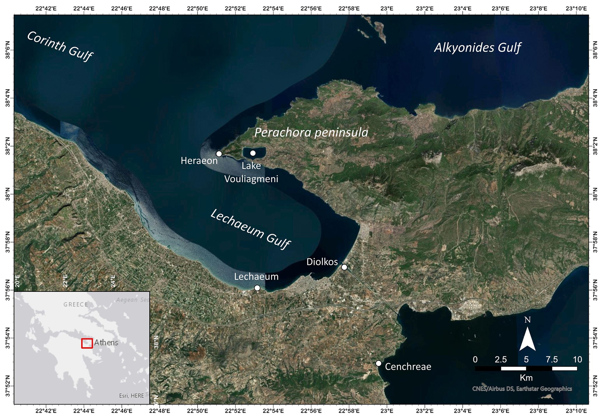
Figure 1Location of the sites discussed in the text. Inset map shows the location of the study area (red box) (created using ArcGIS Pro).
Every year, the Faculty of Geology and Geoenvironment of the National and Kapodistrian University of Athens (NKUA) organizes one field trip for every main course. These field trips are mandatory and free for the students, and they take place in various sites in Greece. For the course of Geomorphology, the field trip normally takes place in the Corinthian gulf (Fig. 1). However, the restrictions due to the COVID-19 pandemic did not allow for its actualization. To address this issue, we created a virtual field trip to the same sites that would normally be visited through the Google Earth platform, in order to aid the students to understand the principles of the course.
This paper focuses on the said virtual field trip. Initially developed as an alternative to the actual field trip that was thwarted due to the COVID-19 pandemic, our goal was to showcase the significance of virtual field trips via this virtual excursion. The main purpose of this work is to evaluate virtual field trips and to evaluate the extent that they can be used as an alternative to real field work, i.e. to what extent they can aid students to comprehend the fundamentals of a course or discipline, especially in situations where visiting an area is not feasible.
The virtual field trip addresses topics such as coastal geomorphology, Holocene relative sea-level changes and sea-level indicators, palaeogeographic evolution, morphotectonics, and palaeo-earthquakes. For the field trip design, bibliographical references were studied on the geological, geomorphological, tectonic and archaeological characteristics of the study area. Additionally, topographical, geological and other maps, as well as satellite images, were studied. The individual sites of the field trip were visited and documented through aerial photography, photographs and videos.
For a complete overview of the field trip, a field trip guide was authored, providing information about the wider area and each of the sites individually. The collected data were imported into ArcGIS software for data analysis and the development of thematic maps. The visualization of this virtual field trip was accomplished through the web platform of Google Earth, through which it is possible to virtually visit and study the landforms of the area, as well as study their relationship to the ancient anthropogenic interventions. Within the Google Earth platform, the main sites were primarily designed with a brief overview text for its main characteristics, which is accompanied with photographic and video material from field work and educational field trips in the area. Because each site contains different features for further analysis, for each site a number of sub-topics were designed in the platform. These are introduced in the platform as placemarks, that can be further enriched with text, photographic material, links, 3D views, etc. Therefore, each main site is first introduced with its location and general information, and then each different topic is presented with text, photographic and video material.
In total, 134 third-year students from the Faculty of Geology and Geoenvironment participated in the virtual field trip. It was initially presented to the students, who also interacted with the platform to complete a post-field-trip exercise. Upon completion, an anonymous questionnaire was distributed to the students in order to evaluate the virtual field trip in terms of their expectations and its usefulness. Overall, the evaluation from students was accomplished through the anonymous questionnaire, which was a self-evaluation; through a post-field-trip exercise; and through the final semester exams of the course.
The Gulf of Corinth is among the most tectonically active regions of Greece (e.g. Moretti et al., 2003; Gaki-Papanastassiou et al., 2007; Jolivet et al., 2013; Charalampakis et al., 2014; Lazos et al., 2020). It lies in the central part of Greece and segregates the Peloponnese, to the south, and Central Greece, to the north. Along its vast scientific significance apropos structural geology and stratigraphy, there are several areas with a vast interest regarding geomorphology, tectonics, relative sea-level changes and geoarchaeology (e.g. Gaki-Papanastassiou et al., 2007; Koukouvelas et al., 2017; Gawthorpe et al., 2018; Zhong et al., 2018; de Gelder et al., 2019; Emmanouilidis et al., 2020), making the area ideal for students to understand coastal geomorphological processes in a tectonically active area.
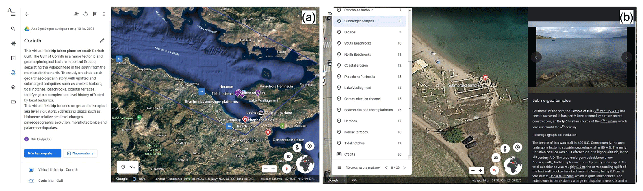
Figure 2(a, b) Examples of the virtual field trip developed on the Google Earth platform. © Google Earth 2021.
The designed virtual field trip can be found at https://earth.google.com/web/data=Mj8KPQo7CiExbm81R3 AwaldGREYyNUFxQXpuREFzZzlsUGNuWjBpNXcSFgoUMDU0NjBGMUE3MzE0RkEyMDNBOEU (Evelpidou et al., 2021) and consists of five sites: Lechaeum, Cenchreae, Diolkos, Lake Vouliagmeni and Heraeon. For each site, the web platform contains geomorphological and geo-archaeological information, as well as its evolution from antiquity to the present day, concerning both the tectonic conditions and its ancient history (Fig. 2).
3.1 Lechaeum
Ancient Corinth had two harbours: Lechaeum on the Corinthian gulf and Cenchreae on the Saronic Gulf. Lechaeum (Lechaion or Lecheae) was an artificial harbour of the Archaic period and is estimated to have been constructed in the 6th century BCE (Rothaus, 1995; Stiros et al., 1996). This site was chosen so that students could comprehend the geomorphic processes that have affected the area, both marine, i.e. changes in the sea level over the centuries, and terrestrial ones, i.e. the increased sediment yield due to both erosion processes and human interventions, which resulted in deepening of the ancient harbour (Morhange et al., 2012). In other words, the students would be able to comprehend its palaeogeographical evolution, as well as the relationship between tectonics and sea-level changes, and the contribution of geo-archaeological indicators and core sampling for the palaeogeographical reconstruction of a site (Fig. 3).
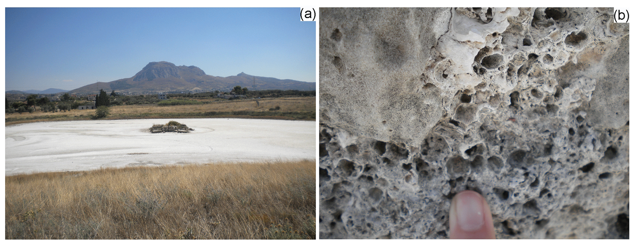
Figure 3(a) Part of the main silted harbour in Lechaeum, in the middle of which a rectangular structure is visible. Coring samples in this area revealed that tectonic uplift in combination with the location of the harbour in a serpentine depression were the primary factors for its abandonment (Morhange et al., 2012). (b) Closer view of the structure where uplifted Balanus perforatus fossils in growth position suggest a biological sea level at +1.2 m, with the age of the uplift at 375 ± 120 cal BCE (Morhange et al., 2012).
The Lechaeum harbour is characterized by a peculiar helical geometry, resembling a natural channel (Morhange et al., 2012). In the area of Lechaeum, beachrocks can be observed, partly covering a construction (probably warehouses of the ancient port), dating back to the Classical period (490–323 BCE), meaning that it formed before 2400 BP. The fact that the beachrocks have covered the ancient construction probably indicates a subsidence of the area, followed by the formation of the beachrocks and eventually the uplift of the area (Stiros et al., 1996; Morhange et al., 2012).
3.2 Cenchreae
Cenchreae (Kenchreai or Kechries) was the eastern harbour of ancient Corinth, located northeast of the Isthmus of Corinth. It was a natural harbour, as opposed to Lechaeum. Cenchreae is surrounded by three main seismic sources, namely the Cenchreae, Loutraki and Aghios Vasileios faults, which have the potential of causing a subsidence of the area, as it is located on the hanging-wall block (Papanikolaou and Roberts, 2011). This site is a characteristic example of an area where tectonic control is intense. Although limited in surface, one can observe both tectonic subsidence and uplift. The reason why this site was chosen is for the students to understand how the said tectonic movements cannot only affect but also determine the geomorphological evolution of an area. Moreover, prominence could be given to the significance of archaeological information in the palaeogeographical evolution of an area. Southeast of Cenchreae harbour, the temple of Isis has been discovered, built in 400 BCE. It has partly been covered by a more recent construction, an early Christian church of the 4th century. The temple of Isis is located at a lower altitude than the early Christian basilica, and the two constructions are currently located below sea level. After the temple of Isis was built, consequently the area was submerged, and the early Christian basilica was built at a higher altitude. The fact that the early Christian basilica is submerged as well indicates that the area has undergone subsidence anew. The total subsidence of the area is roughly 2.5 m, while the corresponding uplift of the foot-wall block, where Lechaeum is found, is 0.7 cm. The subsidence of Cenchreae is due to the Oneia fault zone (Maroukian et al., 1994).
3.3 Diolkos
Diolkos was a paved road used for transporting ships from the Corinthian gulf to the Saronic Gulf, i.e. between Lechaeum and Cenchreae harbours and vice versa, via a wheeled vehicle, where the ships were moored, once emptied of their cargo (Fig. 4a). It was constructed in the 6th century BCE. Its width was 3.5 to 6 m, and its length reached 8 km (Koutsouba and Nakas, 2009).
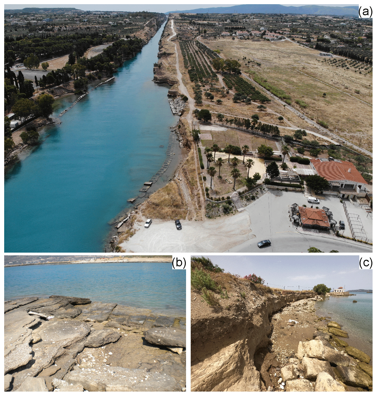
Figure 4(a) A panoramic view of the western part of the isthmus. Diolkos can be seen on the right. (b) The younger beachrock is visible covering part of Diolkos paved road. According to Pirazzoli et al. (2012), two different subsidence phases and an intermediate uplift can be distinguished. (c) The area of Diolkos suffers from intense coastal erosion, and a large part of Diolkos has been destroyed due to erosion, while the coast is under a continuous coastal retreat mainly due to the waves generated by large ships.
The broader area is characterized by the presence of beachrock formations. In Poseidonia, at the exit of the gulf's channel towards the Peloponnese, Diolkos remnants overlie a coarse beachrock. Beachrock fragments were used for the paving of the western part of Diolkos, meaning that the formation, or at least its last phase, is newer than the construction of Diolkos. In the same part of Diolkos, a fine beachrock, dipping to the northeast, covers the pavement and the older, coarse beachrock.
In this site, students can be familiarized with coastal morphodynamic processes and the recognition of previous coastal events, due to changes in the sea level and human interventions, as reflected in coastal features such as beachrocks. Issues of coastal erosion and its documentation are also addressed at this stop, discussing methods and techniques to monitor the phenomenon as well as possible protection measures. Furthermore, the students can deepen their knowledge on relative dating methods, combining archaeology and geomorphology.
3.4 Lake Vouliagmeni
Lake Vouliagmeni (or Lake Heraeon) is a lagoon in Perachora Peninsula (Fig. 5), formed as a karst cavity, and is separated from the sea via an isthmus with a minimum width of 8–10 m. According to Gaki-Papanastassiou et al. (1997), in the broader area, beachrocks have been found at a maximum altitude of +3 m, forming four levels (+3, +2, +1 and +0.4 m). The ones at +1 and +0.4 m are wider and cover a significant part of the coastal zone, whereas the ones at +3 and +2 m are only found locally. It is worth mentioning that along the lake's coast, lacustrine beachrocks have been found at an altitude of 1.4–1.6 m, underlying the Early Helladic settlement, which indicates that these beachrocks are older than the settlement (> 3200 BCE) (Gaki-Papanastassiou et al., 1997).

Figure 5Aerial view of Lake Vouliagmeni, formed as a karst cavity. On the bottom part of the image, the artificial channel is visible, constructed a century ago, connecting the lake with the sea. According to Stiros (1995), the level of the lake corresponded to the sea level, even in antiquity.
Some of the most intriguing landforms of this site are the lacustrine beachrocks, which are very rare features. Their observation can help the students to understand their formation processes better. During the live field trip, they would have the ability to view, study and create geomorphological maps as well. The geomorphological mapping is a very important aspect of the field work. Yet, it could not be performed virtually.
3.5 Heraeon
The small harbour of Heraeon is located at the far western edge of Perachora Peninsula, to the west of Lake Vouliagmeni, where remnants of the temple of Hera have been found. In Perachora Peninsula, there are at least three uplifted Pleistocene marine terraces at 6.5–13, 25–28 and 45 m (Fig. 6a). Several authors (e.g. Vita-Finzi, 1993; Pirazzoli et al., 1994; Dia et al., 1997; Leeder et al., 2005) have stated that the peninsula has undergone constant uplift from Late Quaternary to Holocene, with a mean uplift rate of the area of 0.2 mm yr−1 for the last 220 000 years. Additionally, in the area, remnants of uplifted tidal notches have been found in Mesozoic carbonate cliffs, at altitudes of +3.2 ± 0.2, +2.6 ± 0.2, +1.7 ± 0.2 and +1.1 ± 0.2 m (Pirazzoli et al., 1994) (Fig. 6b, c).
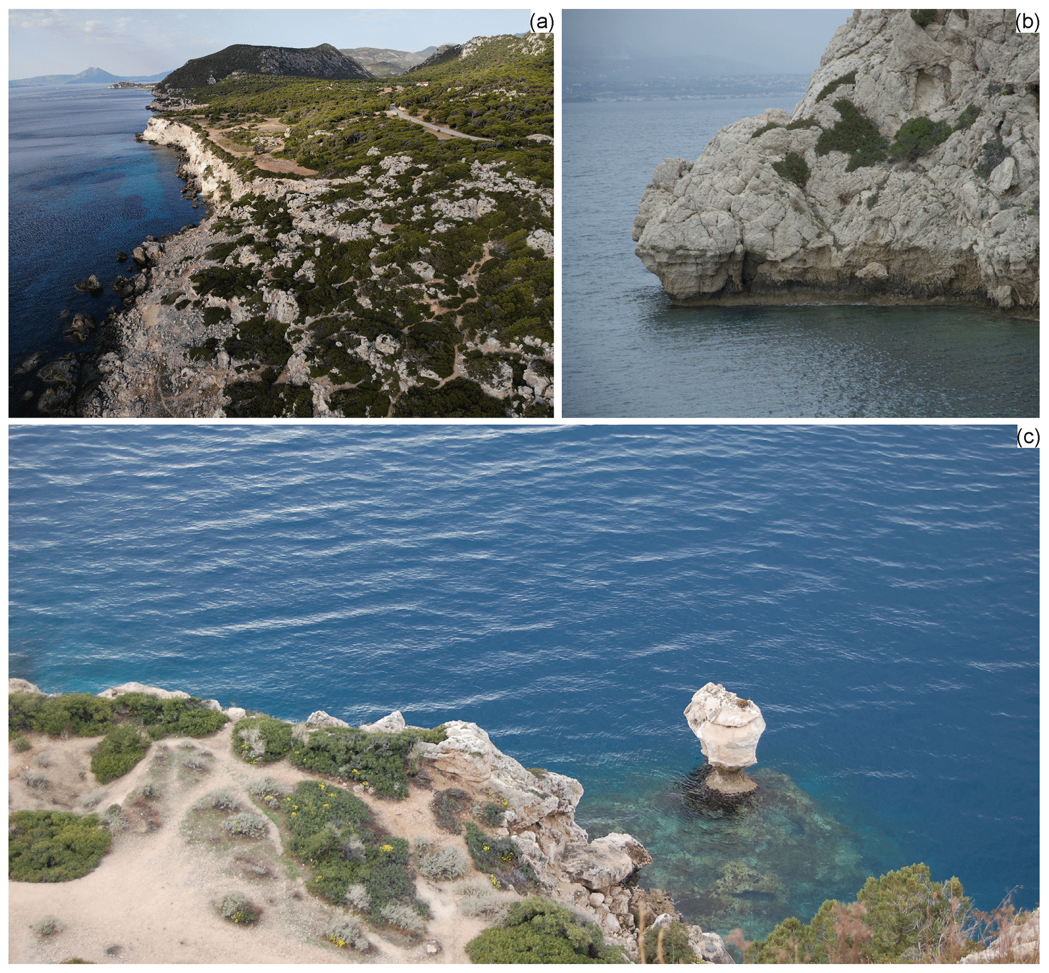
Figure 6Morphotectonic indicators in Perachora Peninsula, revealing an uplifting regime in the area from Late Quaternary to Holocene, in the form of (a) Pleistocene marine terrace at about 20–25 m, which was dated at about 128 ± 3 ka, based on a sample of Cladochora caespitosa (Vita-Finzi, 1993). (b) Multiple remains of uplifted tidal notches were studied by Pirazzoli et al. (1994) at altitudes of +3.2 ± 0.2, +2.6 ± 0.2, +1.7 ± 0.2 and +1.1 ± 0.2 m, documenting uplift events since 440–4320 BCE. (c) Characteristic mushroom-shaped rock, with an uplifted tidal notch, about 150 m to the east of (b) (Pirazzoli et al., 1994).
In this site, students are better acquainted with the morphotectonic evolution of coastal areas, based on sea-level indicators, both geomorphological, such as marine notches and terraces, and biological. In addition, emphasis is given to various dating methods and consequently to the rates of relative sea-level change.
The anonymous questionnaire was filled out by 51 students from the Faculty of Geology and Geoenvironment (NKUA), who follow the course of Geomorphology (Fig. 7). About 82 % of the students who attended the virtual field trip had not attended another virtual field trip before. And 80 % of them would attend one such field trip again, even when the restrictions due to the pandemic were abrogated, both for educational reasons and in order to prepare themselves for an actual field trip. The main reasons were the ability to “visit” remote areas and view satellite images, the ease of their usage, the saving of time and the ability to panoramically view a site; 78 % stated that they would prefer to use virtual field trips instead of a PowerPoint presentation, for instance, in order to educate other trainees.
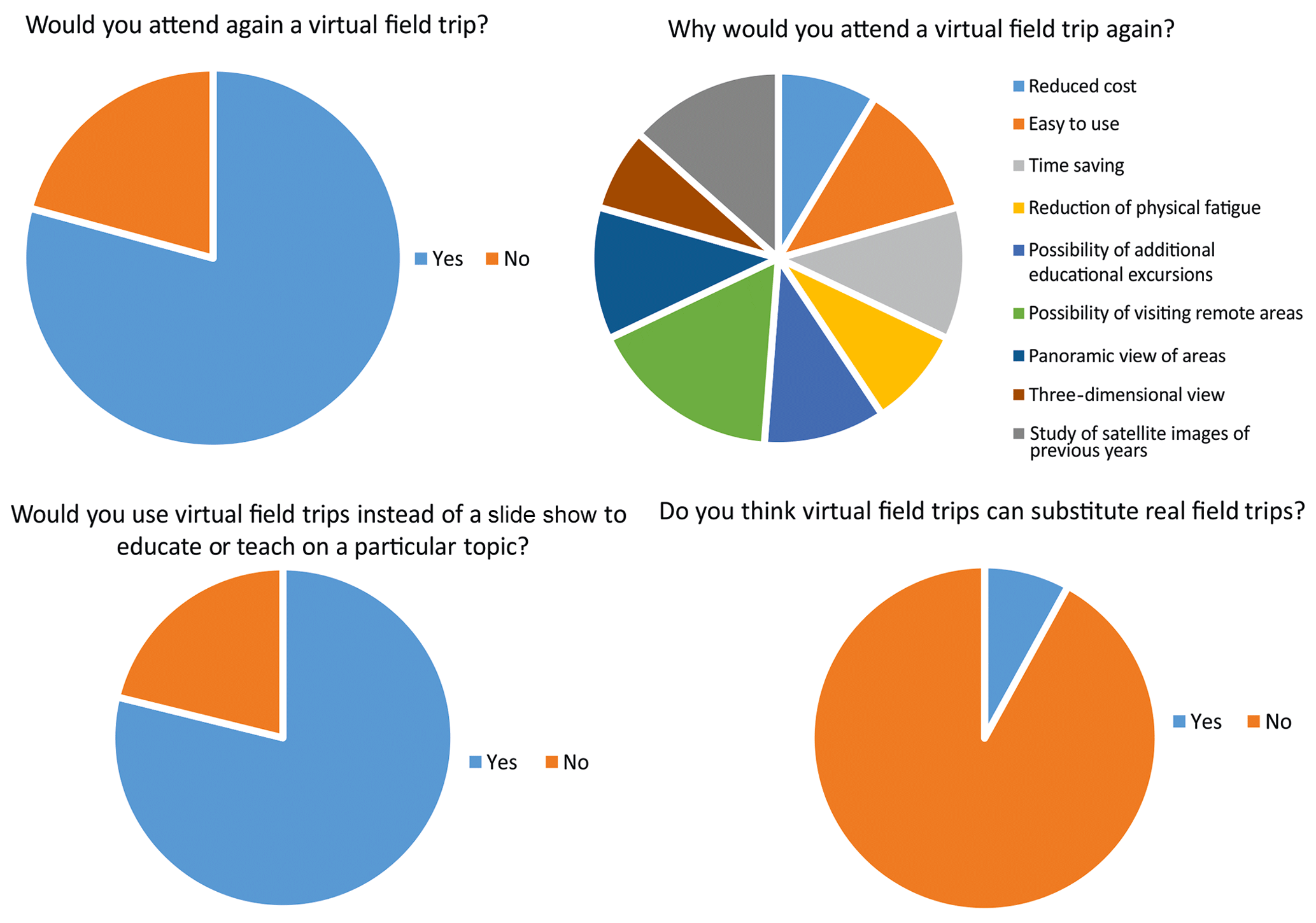
Figure 7Representative pie charts on the students' responses. The students were asked to select an answer amongst a list of choices.
Approximately 90 % of the students stated that it offered them useful information about the studied sites. Three-quarters (75 %) declared that the means of this field trip was satisfactory, given the pandemic conditions.
However, more than 88 % of the students stated that a virtual field trip cannot substitute an actual one. Amongst these students, 49 % mentioned the restrictions of virtual field trips in comparison to actual field work. For more than half (56 % among the 88 %), the most important drawback of virtual field work is the inability to observe geological structures and landforms with their own eyes. According to them, through virtual field trips one cannot improve their observation skills as a geologist or geology student, whereas one cannot observe a site from different viewpoints in contrary to live field work. Additionally, through an online platform, one cannot view and/or recognize a landform or feature in detail, especially one that is relatively small in size. Among the students who considered that a virtual field trip cannot substitute an actual one, 32 % considered another restriction of virtual field trips to be the decreased interaction with other students, educators and nature; through virtual field work, they cannot collect rock and other samples nor feel or touch the rocks and other geological features.
In terms of students' evaluation, about 80 % of students were aided in the understanding of the fundamentals of the course of Geomorphology, based on self-evaluation. Further evaluation of the students was accomplished through a post-field-trip exercise and the final semester exams of the course, where a high percentage of students answered successfully. The final semester exams of the course included questions relevant to the virtual field trip content, coastal landforms, geo-archaeological sea-level indicators, and geochronological methods and their applications.
The purpose of this virtual field trip was for geoscience students to understand the geological and geomorphological processes that have formed the relief of the studied sites, both endogenous, i.e. tectonic uplift and subsidence, and exogenous, i.e. erosion, deposition, biological activity, etc. In its entirety, this virtual field trip aimed to aid trainees in recognizing several coastal landforms, understanding their formation processes, and identifying several geo-archaeological sea-level indicators as well as understanding the recent evolution of the individual studied sites based on their observations. In addition, we intended to help our students understand the most common geochronological methods and their applications.
What is more, the usage of the Google Earth platform could give the students the ability to view the sites of interest in three dimensions and from different aspects, thus aiding the understanding of their spatial arrangement. Moreover, this virtual field trip aimed for the students' familiarization with geological and geomorphological maps, as well as satellite images.
According to the students' answers to the questionnaire and their comments, they were aided by this virtual field trip and the provided multimedia material. Most students obtained useful information about the virtually visited sites, and they understood better the principles of the course of Geomorphology, as well as other geological courses. What is more, most of the students would attend and/or create virtual field trips, even after the restrictions due to the COVID-19 pandemic have been abrogated, not only in order to prepare themselves for in situ educational field trips or field research but also as a means of education as well.
Virtual field trips have not been shown to be effective in achieving student outcomes and as such should not be used to replace field experiences. A characteristic answer from the questionnaire states that “Virtual field trips are effective as supplementary of live fieldwork, but they can never substitute the realistic conditions and the direct interaction with the field and nature”. However, given that they offer the students interactivity in comparison to traditional passive learning methods that can be used in the classroom (e.g. Ramasundaram et al., 2005; Cliffe, 2017), they can be used as a means of preparation for actual field work, concerning both the sites to be visited and the students' obligations when they visit them. Moreover, virtual field trips are very useful in visiting remote areas and/or sites that are not accessible (Stainfield et al., 2000), and they are a valuable tool for disabled students, who are unable to visit many areas (Hurst, 1997; Gilley et al., 2015). What is more, existing field work can be improved by means of a virtual field trip, as the same sites can easily be visited anew, and more observations can be made. Existing field work can be improved with better before-hand preparation for panoramic observations and for revisiting complex sites or locations.
Yet, as helpful and useful as they can be, virtual field trips do have certain drawbacks in comparison to actual field trips that are worth mentioning. These drawbacks do not concern solely academic students but all education levels, such as pupils (e.g. Spicer and Stratford, 2011; Mead et al., 2019). Initially, educational field trips and scientific field work pose a unique experience to both trainees and educators, as they have the ability to communicate to each other in the flesh and to co-operate and develop a team spirit (e.g. Clark, 1996). Additionally, understanding the fundamentals of any course in the field is highly aided by the contribution of the students' senses. These senses do not refer solely to seeing and observing landforms but include sound, smell, touch and even taste. Virtual trips deprive the students of these types of interactions with each other, with the educators, with nature and with the landscape (e.g. Çalışkan, 2011; Han, 2020).
What is more, for the vast majority of students and especially geoscience ones, actual field trips are far more beneficial in recognizing geological structures and landforms and understanding their formation processes as well as their significance in geological surveys (e.g. Hurst, 1997). Within a few hours in the field, one can learn and comprehend much more than during a significant amount of time in the classroom. And it should be mentioned that what is taught in the field is far more likely to be remembered than in the classroom. For instance, it has already been mentioned that one of the purposes of this field trip was to aid students to view and use geomorphological maps and create their own ones. Yet, this could not be performed through the virtual version of the trip, as high-accuracy aerial photos and stereoscopical observations would be needed. Even though this can be improved in the near future, small-scale landforms, stratigraphic boundaries and other features could not be observed well, as their scale is not large enough to be distinguished with the used platform. However, other means for the design of virtual field trips, such as 360∘ videos have the possibility to improve certain aspects of such an activity, offering a more detailed view on particular geomorphological features.
Virtual field trips can supplement the physical fieldwork and are a succor in any field trip and/or field work, offering both students and educators/researchers the ability to prepare themselves. According to the student responses, the designed virtual field trip achieved its goal, as they improved their understanding of the course of Geomorphology, and they were satisfied by attending a virtual field trip, given the pandemic conditions. Virtual field trips can be a useful tool for additional field work in places with difficult access, for people with mobility problems, for improving existing field work with better before-hand preparation, for panoramic observations and for revisiting complex sites or locations.
Yet, under no circumstances can they substitute actual field trips. The students' interactions with each other, the educators and nature are essential in the effectiveness of a field trip, and this is only the case when this trip is physical. It is also worth noting that the feedback of geoscience students is essential to improve virtual field trips and create more inclusive activities.
The virtual field-trip was designed on the web version of Google Earth, which is freely available.
No other datasets than those presented in the cited articles have been used for the virtual field-trip design. Results from the anonymous questionnaires are available from the authors upon request. The virtual field trip is freely available at the following link: https://earth.google.com/web/data=Mj8K PQo7CiExbm81R3AwaldGREYyNUFxQXpuREFzZzlsUGNuWj BpNXcSFgoUMDU0NjBGMUE3MzE0RkEyMDNBOEU (Evelpidou et al., 2021).
NE conceived and directed the project. NE, ES, GS and AK contributed to the design of the virtual field trip. NE, AK, GS and ES contributed to the analysis of the results and the writing of the paper.
The authors declare that they have no conflict of interest.
Publisher’s note: Copernicus Publications remains neutral with regard to jurisdictional claims in published maps and institutional affiliations.
This article is part of the special issue “Virtual geoscience education resources”. It is not associated with a conference.
We would like to thank Efthimios Karymbalis and one anonymous referee, whose comments improved an earlier version of this article.
This paper was edited by Marlene Villeneuve and reviewed by Efthimios Karymbalis and one anonymous referee.
Behrendt, M. and Franklin, T.: A review of research on school field trips and their value in education, Int. J. Environ. Sci. Educ., 9, 235–245, 2014.
Çalışkan, O.: Virtual field trips in education of earth and environmental sciences, Proc. Soc. Behv, 15, 3239–3243, 2011.
Carmichael, P. and Tscholl, M.: Cases, simulacra and semantic web technologies, J. Comput. Assist. Lear., 29, 31–42, https://doi.org/10.1111/j.1365-2729.2011.00459.x, 2011.
Charalampakis, M., Lykousis, V., Sakellariou D., Papatheodorou, G., and Ferentinos, G.: The tectono-sedimentary evolution of the Lechaion Gulf, the south eastern branch of the Corinth graben, Greece, Mar. Geol., 351, 58–75, 2014.
Clark, D.: The changing national context of fieldwork in geography, J. Geogr. Higher Educ., 20, 385–391, 1996.
Cliffe, A. D.: A review of the benefits and drawbacks to virtual field guides in today's Geoscience higher education environment, Int. J. Educ. Tech. Higher Educ., 14, 28, https://doi.org/10.1186/s41239-017-0066-x, 2017.
de Gelder, G., Fernández-Blanco, D., Melnick, D., Duclaux, G., Bell, R. E., Jara-Muñoz, J., Armijo, R., and Lacassin, R.: Lithospheric flexure and rheology determined by climate cycle markers in the Corinth Rift, Sci. Rep., 9, 4260, https://doi.org/10.1038/s41598-018-36377-1, 2019.
Dia, A. N., Cohen, A. S., O'Nions, R. K., and Jackson, J. A.: Rates of uplift investigated through 230Th dating in the Gulf of Corinth (Greece), Chem. Geol., 138, 171–184, 1997.
Emmanouilidis, A., Unkel, I., Triantaphyllou, M., and Avramidis, P.: Late-Holocene coastal depositional environments and climate changes in the Gulf of Corinth, Greece, Holocene, 30, 77–89, 2020.
Evelpidou, N., Karkani, A., Saitis, G., Spyrou, E., and Lykouropoulos, M.: Virtual fieldtrip – Corinth, Google Earth, https://earth.google.com/web/data=Mj8KPQo7CiExbm81R3A waldGREYyNUFxQXpuREFzZzlsUGNuWjBpNXcSFgoUM DU0NjBGMUE3MzE0RkEyMDNBOEU, last access: 2 August 2021.
Gaki-Papanastassiou, K., Papanastassiou, D., and Maroukian, H.: Recent Uplift Rates at Perachora Peninsula, East Gulf of Corinth, Greece, based on Geomorphological – Archaeological Evidence and Radiocarbon Dates, Hellenic Journal of Geosciences, 42, 45–56, 1997.
Gaki-Papanastassiou, K., Papanastassiou, D., and Maroukian, H.: Recent uplift rates at Perachora peninsula east Gulf of Corinth, Greece, based on Geomorphological – Archaeological evidence and radiocarbon dates, Hell. J. Geosci., 42, 1–12, 2007.
Gawthorpe, R. L. Leeder, M. R., Kranis, H., Skourtsos, E., Andrews, J. E., Henstra, G. A., Mack, G. H., Muravchik, M., Turner, J. A., and Stamatakis, M.: Tectono-sedimentary evolution of the Plio-Pleistocene Corinth rift, Greece, Basin Res., 30, 448–479, 2018.
Gilley, B., Atchison, C., Feig, A., and Stokes, A.: Impact of inclusive field trips, Nat. Geosci., 8, 579–580, https://doi.org/10.1038/ngeo2500, 2015.
Han, I.: Immersive virtual field trips in education: A mixed-methods study on elementary students' presence and perceived learning, Brit. J. Educ. Tech., 51, 420–435, 2020.
Hurst, S. D.: Use of “virtual” field trips in teaching introductory geology, Comp. Geosci., 24, 653–658, 1997.
Jacobson, A. R., Mitello, R., and Baveye, P. C.: Development of computer-assisted virtual field trips to support multi-disciplinary learning, Comp. Educ., 52, 571–580, 2009.
Jolivet, L., Faccenna, C., Huet, B., Labrousse, L., Le Pourhiet, L., Lacombe, O., Lecomte, E., Burov, E., Denèle, Y., Brun, J. P., Philippon, M., Paul, A., Salaün, G., Karabulut, H., Piromallo, C., Monié, P., Gueydan, F., Okay, A. I., Oberhänsli, R., Pourteau, A., Augier, R., Gadenne, L., and Driussi, O.: Aegean tectonics: Strain localisation, slab tearing and trench retreat, Tectonophysics, 597–598, 1–33, 2013.
Koukouvelas, I. K., Zygouri, V., Papadopoulos, G. A., and Verroios, S.: Holocene record of slip-predictable earthquakes on the Kenchreai Fault, Gulf of Corinth, Greece, J. Struct. Geol., 94, 258–274, 2017.
Koutsouba, D. and Nakas, G.: Diolkos: a significant engineering structure of Antiquity, National Conference “Corinthia and the Northeast Peloponnesus”, 26–29 March 2009, Loutraki, Greece, 2009 (in Greek).
Lazos, I., Chatzipetros, A., Pavlides, S., Pikridas, C., and Bitharis, S.: Tectonic crustal deformation of Corinth gulf, Greece, based on primary geodetic data, Acta Geodyn. Geomater., 17, 413–424, 2020.
Leeder, M. R., Portman, C., Andrews, J. E., Collier, R. E. L., Finch, E., Gawthorpe, R. L., McNeill, L. C., Perez-Arlucea, M., and Rowe, P.: Normal faulting and crustal deformation, Alkyonides Gulf and Perachora peninsula, eastern Gulf of Corinth rift basin, Greece, J. Geol. Soc. Lond., 162, 549–561, 2005.
Maroukian, H., Gaki-Papanastassiou, K., and Papanastassiou, D.: Coastal changes in Corinthia, Greece, in: RES MARITIMAE: Cyprus and the Eastern Mediterranean from Prehistory to Late Antiquity, edited by: Swiny, S., Hohlfelder, R. L., and Wylde Swiny, H., Scholars Press, Atlanta, Georgia, USA, 217–226, 1994.
Mead, C., Buxner, S., Bruce, G., Taylor, W., Semken, S., and Anbar, A. D.: Immersive, interactive virtual field trips promote science learning, J. Geosci. Educ., 67, 131–142, https://doi.org/10.1080/10899995.2019.1565285, 2019.
Moretti, I., Sakellariou, D., Lykousis, V., and Micarelli, L.: The Gulf of Corinth: an active half graben?, J. Geodyn., 36, 323–340, 2003.
Morhange, C., Pirazzoli, P., Evelpidou, N., and Marriner, N.: Late Holocene Tectonic Uplift and the Silting Up of Lechaion, the Western Harbor of Ancient Corinth, Greece, Geoarchaeology, 27, 278–283, 2012.
Papanikolaou, I. and Roberts, G.: Stop 5: Submerged harbor and temple at Kechriai, in: Active Tectonics and Earthquake Geology of the Perachora Peninsula and the Area of the Isthmus, Corinth Gulf, Greece, edited by: Roberts, G., Papanikolaou, I., Vött, A., Pantosti, D., and Hadler, H., The Natural Hazards Laboratory, National and Kapodistrian University of Athens, Athens, Greece, 66–70, 2011.
Pirazzoli, P., Evelpidou, N., and Mourtzas, N.: Stop 3 Diolkos: Geomorphological evidence, in: Fieldtrip guide: Sea level indicators in south Corinth Gulf, edited by: Pirazzoli, P., Evelpidou, N., Stamatakis, M., and Tziligkaki, E., Athens, Greece, 26–27, 2012.
Pirazzoli, P. A., Stiros, S. C., Arnold, M., Laborel, J., Laborel-Deguen, F., and Papageorgiou, S.: Episodic uplift deduced from Holocene shorelines in the Perachora Peninsula, Corinth area, Greece, Tectonophysics, 229, 201–209, 1994.
Ramasundaram, V., Grunwald, S., Mangeot, A., Comerford, N. B., and Bliss, C. M.: Development of an environmental virtual field laboratory, Comp. Educ., 45, 21–34, 2005.
Rothaus, R.: Lechaion, western port of Corinth: a preliminary archaeology and history, Oxford J. Archaeol., 14, 293–306, 1995.
Spicer, J. I. and Stratford, J.: Student perceptions of a virtual field trip to replace a real field trip, J. Comput. Assist. Lear., 17, 345–354, 2011.
Stainfield, J., Fisher, P., Ford, B., and Solem, M.: International Virtual Field Trips: a new direction?, J. Geogr. Higher Educ., 24, 255–262, 2000.
Stiros, S., Pirazzoli, P., Rothaus, R., Papageorgiou, S., Laborel, J., and Arnold, M.: On the date of construction of Lechaion, western harbour of Corinth, Greece, Geoarchaeology, 11, 251–263, 1996.
Stiros, S. C.: Palaeogeographic reconstruction of the Heraion-Vouliagmeni Lake coast since Early Helladic times, Annu. Br. Sch. Athens, 90, 17–21, 1995.
Vita-Finzi, C.: Evaluating the Quaternary uplift in Greece and Cyprus, in: Magmatic Processes and Plate tectonics, edited by: Prichard, H. M., Alabaster, T., Harris, N. B. W., and Neary, C. R., Special Publication of the Geological Society, 76, 417–424, 1993.
Zhong, X., Escalona, A., Sverdrup, E., and Bukta, K. E.: Impact of fault evolution in Gilbert-type fan deltas in the Evrostini area, south-central Gulf of Corinth, Greece, Mar. Petrol. Geol., 95, 82–99, 2018.