the Creative Commons Attribution 4.0 License.
the Creative Commons Attribution 4.0 License.
 | 04 Sep 2020
Boundary|Time|Surface: assessing a meeting of art and geology through an ephemeral sculptural work
Sydney A. Lancaster
John W. F. Waldron
Boundary|Time|Surface was an ephemeral, site-specific sculpture created to draw attention to the construction of social, political, scientific, and aesthetic boundaries that divide the Earth; one such practice is the scientific subdivision of geologic time. The sculpture comprised a 150 m fence along the international stratotype separating Ordovician from Cambrian strata in Gros Morne National Park, Canada. The fence was constructed by hand within 1 d, on a falling tide, from materials found on site, with minimal environmental impact. During the following tidal cycles, it was dismantled by wave and tide action. This cycle of construction and destruction was documented with time-lapse photography and video and brought to the public through exhibitions, public talks, and a book. Exhibitions derived from the documentation of ephemeral works function as translations of the original experience. In this case, they provided opportunities for public interaction with media that served both as aesthetic objects and as sources of information about the site's geological and sociopolitical history. We assess the role of the installation, and its documentation, in drawing public attention to boundaries, and examine responses including attendance records and written visitor comments as indications of the viewers' engagement with the concepts presented. Of several thousand visitors to exhibitions, 418 written comments reflected the viewers' engagement with both the location and the underlying concepts. Both the original installation and the subsequent work allowed audiences to explore human understanding and acquisition of knowledge about the Earth and how world-views inform the process of scientific inquiry.
- Article
(22812 KB) - Full-text XML
-
Supplement
(8483 KB) - BibTeX
- EndNote


Geologists and artists have taken different approaches to documenting features of the Earth and have communicated these approaches to largely different segments of the population. Geology has as its basis the establishment of limits and boundaries within the Earth. Pioneers of geology defined the periods of the geologic timescale with the intent to represent natural chapters in Earth history; from their colonialist perspective, it was anticipated that these would have global application. Since the mid-20th century, stratigraphers have attempted to resolve the resulting gaps and overlaps created by this assumption by establishing international stratotypes. One such stratotype is located on the west coast of the large island known as Ktaqamkuk by the indigenous Mi'kmaq, Terre-Neuve by its early French settlers, and Newfoundland (NL) by its Anglophone population within the political structure of modern Canada. It is situated at Green Point in Gros Morne National Park, a location that receives several thousand visitors annually; despite the site's popularity, visitors struggle to grasp its geological significance.
An outdoor ephemeral art installation, Boundary|Time|Surface, provided a brief, site-specific opportunity for viewers to contemplate the enormity of geological time and the fragile and arbitrary nature of human-defined boundaries. The installation was followed by a series of exhibitions, talks, and a book aimed at bringing it to a larger audience with interests in both artistic and scientific endeavours. We here describe and evaluate the ways in which the project has informed our respective practices and how the reach of the original ephemeral work has been, and continues to be, extended so as to inform a larger audience.
“Earth art”, “land art”, and “environmental art” describe a range of approaches to art making, from major, permanent interventions in the landscape to extremely ephemeral activities. In the United States, this style of art making was pioneered by Robert Smithson, whose Spiral Jetty (1970) incorporated over 6000 t of basalt and earth moved from industrial wasteland on the shore of Great Salt Lake to form a spiral in the lake's water that measured 4.4 m by 460 m (The Art Story, 2015). As a work that responded directly to the geology and specific details of the landscape (Smithson, 1996), Spiral Jetty also had an unexpected relationship to the growing awareness of anthropogenic environmental change; the installation was submerged due to rising lake levels in 1972 and subsequently re-emerged, covered with a layer of evaporite deposits, during lake-level fall in 2002 (Casey, 2005; Hopkins, 2000). More explicitly connected with the phenomena studied by Earth science is James Turrell's Roden Crater (begun in 1972), a massive structure of connecting rooms and tunnels built into an extinct volcanic cinder cone in the Painted Desert in northern Arizona, USA (Cook, 2010). This artwork has thus far included the movement of ∼106 m3 of earth. When completed, the project is planned to contain 21 viewing spaces and six tunnels, a temple-like space allowing visitors to experience celestial events (Fredricksen, 2002; Turrell, 2020).
An alternative land art tradition arose in the UK. One of the earliest practitioners in this tradition, Richard Long, has been characterized as a “walking artist”. Beginning in the 1960s, Long created a series of artworks based on multiday walks through the landscape (Dapena-Tretter, 2014) and the documentation of these journeys in photographs, maps, and text works – a process with some parallels in geological mapping as practitioners thereof have long been expected to walk long distances over rugged ground during the collection of geological data. Long also works in site-specific sculptural installations, often using natural materials found on location in the landscape (Long, 2020). Likewise, Scottish artist Andy Goldsworthy has created site-responsive works of various sizes throughout his career. Many of his artworks are made from ephemeral, organic materials (Tufnell, 2006); the natural life cycle of the materials at hand is intrinsic to the work itself, as is its eventual disappearance (Gooding, 2002; The Art Story, 2018). Several of Goldsworthy's projects have involved explicit reference to Earth science phenomena (Lubow, 2005). One work, created from driftwood on the shores of the Bay of Fundy in Nova Scotia, Canada, evoked hydrological phenomena that occur in the bay itself (Goldsworthy, 2000). Goldsworthy has also created a number of works that echo the shape of meandering rivers; these have been carved out of sediment or snow or drawn on a range of surfaces with water (Goldsworthy, 2000).
Artistic creations such as these help to bring awareness of the phenomena studied by Earth scientists to an audience that would not otherwise undertake formal training in geology or related subjects and introduce metaphorical and symbolic ways of thinking about the Earth that are different from those employed by scientists and science students. Thus, work of this type offers opportunities to bridge the worlds of scientific research, artistic practice, and the general public by offering visual imagery and material objects that refer to natural processes and scientific concepts in ways that can provoke new connections and a deeper understanding of perspectives on the natural world.
Boundaries reflect a common human desire for a sense of permanence in the world; humans retain a psychological and emotional attachment to the notion that both ideas and objects, such as fences and borders, are in some way permanent (Nail, 2016) despite a range of indications to the contrary. Boundaries are perceived as enduring marks made by humanity that simultaneously prove our importance in the history of the planet and assure us that there are fixed points upon which we can feel assured of ongoing security outside the passage of time and (sometimes dramatic) sociopolitical change (Wood, 2019).
Individuals speak colloquially of “crossing the line”, “drawing a line in the sand” or even “invading personal space” to mark various limits and points of transgression. So, too, social and political entities create borders, erect boundary markers, and declare and define limits that identify places, things, and people and, thus, privilege certain ways of knowing over others. Both the container and information therein are subjective creations expressing power relations in physical and temporal space (Zeller, 2000).
Boundary|Time|Surface was created, drawing on the UK land art tradition, as an intervention within a specific landscape to address these ideas. Undertaking this project itself represented a challenging of disciplinary boundaries and discipline-specific modes of thinking. Both the artist and the scientist had a desire to come to the project as “equal but different” in their expertise and in their approaches to the planning and execution of the original sculptural installation and subsequent elements of the project. This positioning of our roles and respective disciplines was an active choice; the product of several extended discussions in which each participant explored their assumptions about the work within the other collaborator's discipline. As such, these discussions could be described as “boundary-work” (Gieryn, 1995; Rödder, 2017). We were concerned with establishing common ground, both in terminology and in the approach to the work to be undertaken, as the initial installation project was an extended time commitment and physically demanding. As such, we were self-selecting for co-production of the work at this stage (Rödder, 2017).
Ephemeral artworks such as Boundary|Time|Surface have limitations in their reach. We understood that to communicate our “findings” for this project we had to rely upon various methods of documentation, both as lasting records of our works' existence and as tools to extend the reach of the original project. These included a series of exhibitions, public talks, and a limited-edition artist book.
The recognition that strata record a succession of events in geological history was a product of Renaissance natural philosophy (e.g. Steno, 1669). An important proponent of the relationship between strata and time was James Hutton (Hutton, 1788), who implied that the landscape in which he lived could be divided according to the succession of the underlying rock units in Earth history. Hutton saw this geological evidence of ongoing processes as part of a larger human-centred system “… particularly adapted to the purpose of man, who inhabits all its climates, who measures its extent, and determines its productions at his pleasure” (Hutton, 1788). However, this subdivision was not realized until the early 19th century in the work of William Smith, who produced what was arguably the first geological map (Smith, 1815; Winchester, 2002). Smith marked the outcrop extent of strata in different colours, separated by boundaries drawn on a map of the landscape.
The challenge of extending Smith's paradigm to the remaining unmapped areas of Britain was taken up by a number of 19th century geologists, notably Adam Sedgwick and Roderick Murchison, whose work on the geology of Wales and the Welsh borders (Sedgwick and Murchison, 1836) established the Silurian and Cambrian systems, respectively, in the Welsh borders and in the central parts of the Welsh basin. Charles Lapworth (1879) proposed the establishment of the Ordovician system, broadly encompassing the strata overlapped by Sedgwick and Murchison, between an unconformity at the base of the Arenig Series and another unconformity at the base of the Llandovery Series.
At the time, the periods of the geological timescale were regarded as natural chapters in a cohesive Earth history separated by major upheavals and even global catastrophes. Perhaps informed by colonialist perspectives prevalent at the time (Chandna, 2009; Harrison, 2005; Zeller, 2000), early geologists expected the boundaries defined in Europe to be traceable all over the world. As a result, many of the boundaries introduced in the early 19th century were placed either at unconformities (with the unsatisfactory result that a span of geologic time was unrepresented at the boundary) or at major facies changes (with the result that faunal changes represented environmental, local events rather than global, evolutionary changes). For example, the original boundary between the Silurian and Devonian systems in England and Wales marks the highest occurrence of graptolites, a group of planktonic marine fossils, where conditions changed from marine to largely non-marine (Sedgwick and Murchison, 1839). By 1960, however, it was clear that graptolites persisted in central Europe and North America well after their disappearance in Britain (Becker et al., 2012), and rocks were being characterized as Silurian in these locations that were clearly younger than Devonian rocks in the area of the original definition.
The gaps and overlaps in the geological timescale continued to cause controversy in stratigraphy into the 20th century. These difficulties led to the introduction of the idea of “stratotypes” (e.g. Hedberg, 1976), i.e. designated localities where units are formally defined and with which other sections of strata can be correlated. This approach separates the business of definition of a unit, which is (ideally) done once, from the business of correlation, which is subject to uncertainty, because of the incompleteness of both the geological record and the data collected by geologists. The selection of stratotypes is arbitrary in principle, but in practice it is conditioned by geological significance, historical precedence, and the correlation criteria that are to be used. Thus, stratotypes for units that represent geologic time need to be placed in successions of strata that contain markers that have a wide global distribution and record changes that are as synchronous as possible (typically the first appearance of a new species of marine planktonic or nektonic fossils). Typically, they are placed in sections that have been intensively studied.
The first of the boundaries to be addressed was the Silurian–Devonian boundary, redefined at Klonk in what is now the Czech Republic (Martinsson, 1977), at a younger position in a continuous succession of graptolite-bearing shale. Debate over the choice of other stratotypes marking the boundaries between Phanerozoic systems continued through the succeeding decades of the 20th century; most of them have now been defined by the International Commission on Stratigraphy (ICS; e.g. Gradstein et al., 2012). In some cases, such as the Cretaceous–Paleogene boundary, the traditionally identified horizon marks a sudden global change that is easily correlated worldwide. In other cases, such as the Permian–Triassic and Ordovician–Silurian boundaries, major global change occurs over an interval within which correlation is challenging. For pragmatic reasons, the Permian–Triassic boundary stratotype at Meishan, China, was placed in an interval with cosmopolitan fossils, marking the first recovery from a major extinction event colloquially termed the “great dying” (Ogg, 2012). Similarly, the Ordovician–Silurian boundary at Dob's Linn in Scotland is placed in black shales with abundant, well-described graptolites somewhat above an interval of grey beds, lacking abundant graptolites, that records the “Hirnantian event” of global change to biotas (Cooper et al., 2012; Melchin et al., 2012).
While Lapworth's Cambrian–Ordovician boundary was placed at a local unconformity within the successions of North Wales, 20th century opinion (e.g. Bassett and Dean, 1982) favoured a somewhat lower position at or close to the first appearance of planktonic graptolites. Subsequently, conodonts were found to be more cosmopolitan in their distribution and came to be favoured over graptolites for use in defining the boundary. A succession of fossiliferous Cambrian to Ordovician slope sedimentary rocks formed on the margin of the Paleozoic Iapetus Ocean, namely the Cow Head Group, is exposed on the west coast of Newfoundland–Terre-Neuve–Ktaqamkuk in Canada (Fig. 1a). The succession was initially mapped at Cow Head by Whittington and Kindle (1963), who showed that it spanned the Cambrian–Ordovician boundary. Correlation between the multiple sections along the coast was achieved by James and Stevens (1986) who identified a section at Green Point (Fig. 1b), in Gros Morne National Park, as the most distal part of the slope succession. The succession contains fossils from four different fossil groups that are useful for correlation, namely conodonts, trilobites, graptolites, and radiolarians. The international Global Boundary Stratotype Section and Point (GSSP) for the Cambrian–Ordovician boundary was defined at Green Point in 2001 at the base of the Iapetognathus fluctivagus conodont biozone in the middle of bed 23 of Cooper et al. (2001). This was the location chosen by us for Boundary|Time|Surface.
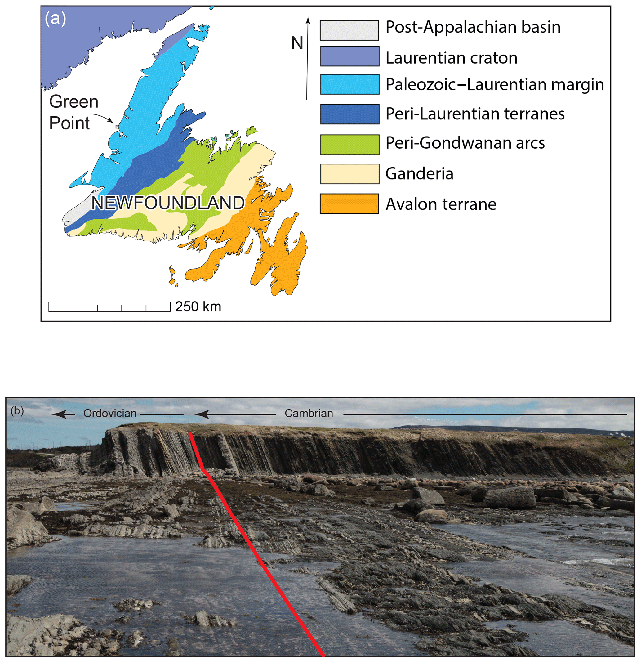
Figure 1(a) Main tectonic subdivisions of Newfoundland, showing the location of Green Point stratotype (based on Lacombe et al., 2019). Coastline made with Natural Earth Data: free vector and raster map data at http://naturalearthdata.com/ (last access: 17 February 2020). (b) View of the cliff at Green Point, Gros Morne National Park, Newfoundland, Canada, at low tide. Red line indicates Cambrian–Ordovician boundary (middle of bed 23), as defined by Cooper et al. (2001).
The Europe-centred development of geological science is illustrated by a map of the worldwide distribution of type areas and stratotypes (Fig. 2a–b). The original 19th century sites where periods of the geological timescale were defined are heavily concentrated in Europe and immediately adjoining areas. Many of the boundaries between these periods were subsequently redefined by the ICS at GSSPs. These sites function as reference points with which other places on the planet are correlated so that Earth scientists can better understand whether changes that took place in the distant past were local or global in scope. At first glance, this process seems relatively straightforward; a point is chosen based on a set of criteria, and the boundary is set. But this is not the case. If the GSSPs were chosen purely on the basis of features intrinsic to the rocks – namely, the excellence of the outcrop and its potential for correlation – an even distribution of GSSPs over the land surfaces of the Earth might be expected. The actual distribution, though more dispersed than that of 19th-century-type areas, still shows a strong bias towards European locations. The reasons for this become apparent when the arguments for the establishment of GSSPs are examined (Gradstein et al., 2012). In many cases, the final choice of a GSSP was made between fiercely contested candidates, each supported by a national scientific community centred in a political territory. Thus, a combination of objective and subjective influences came into play in determining the locations of these boundaries: the weight of evidence, interpretation of information, and sociopolitical influences contributed to each decision. Thus, Green Point was one of several places that could have been chosen for this particular boundary stratotype. As such, this place embodies the nexus of many aspects of the human pursuit of knowledge – and the selectivity with which that knowledge is related and used.
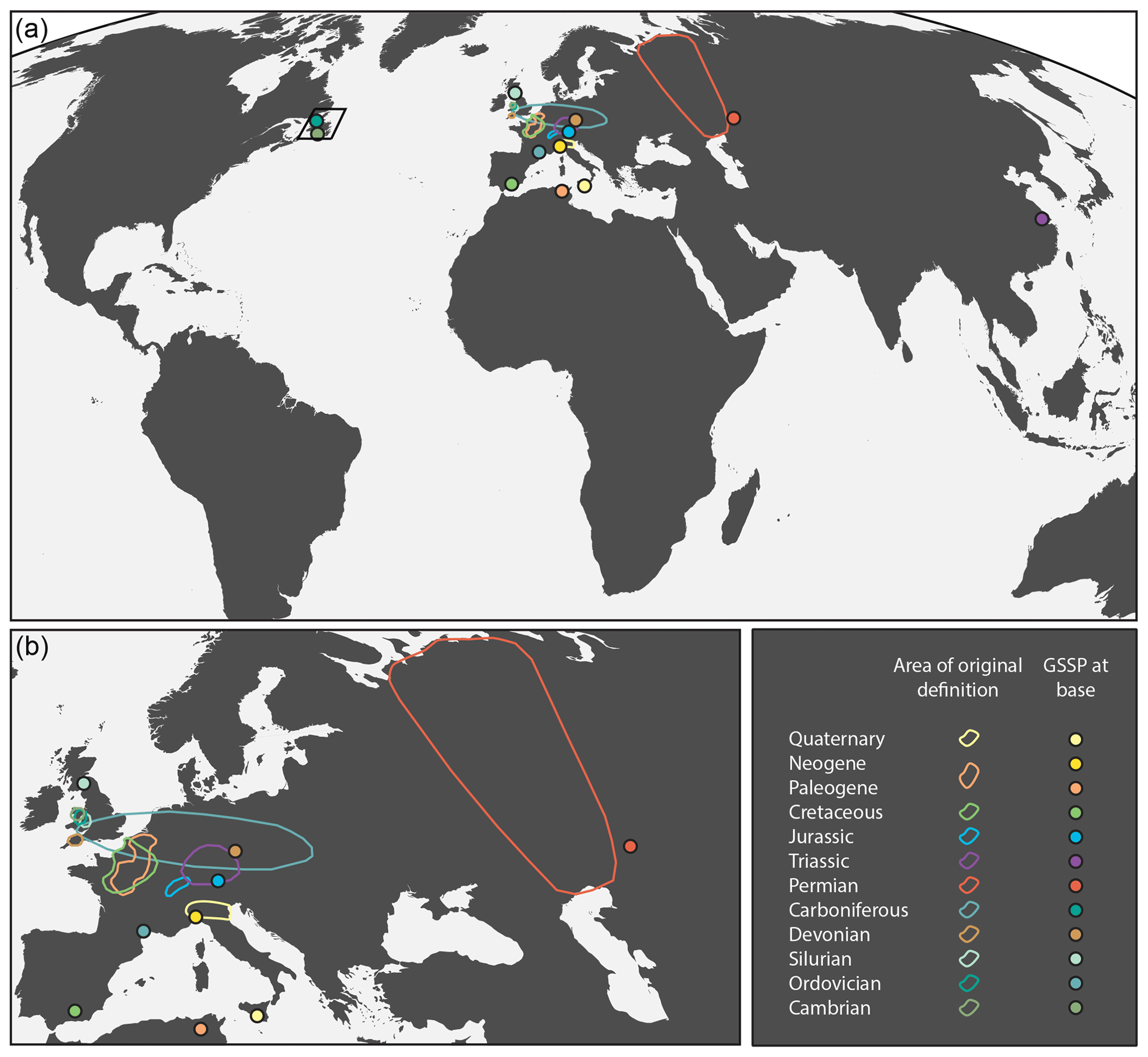
Figure 2(a) Global location of 19th century definition areas of systems in the geological timescale compared with boundary stratotypes defined and proposed by the International Commission on Stratigraphy (ICS) (Gradstein et al., 2012). Box encloses the area of Fig. 1a. Molleweide projection; ICS colour scheme for stratigraphic units. (b) Enlarged portion of (a) showing the concentration of definition areas and stratotypes in Europe. Coastline made with Natural Earth Data: free vector and raster map data at http://naturalearthdata.com/ (last access: 17 February 2020).
3.1 Preparation
Boundary|Time|Surface was developed and executed during a 5 week artist's residency (Art in the Park) at Gros Morne National Park in 2014. As this artwork was being created in a Canadian National Park, it was particularly important to minimize any potential environmental impact that the work's creation might have. We used only natural materials found on or close to the site. This was an active decision appropriate to both the Parks Canada mandate and regulations and to the underlying approach to the work.
The initial task in preparing for the installation was establishing the location of the Cambrian–Ordovician (C–O) boundary at Green Point as per the description in Cooper, Nowlan, and Williams' (2001) paper. Having established the location of bed 23 – designated as the Cambrian–Ordovician boundary – we traced the bed out onto the wave-cut platform to the low-water mark in order to establish the extent of the work. The boundary horizon lies in a succession of rhythmically bedded shale and fine-grained limestone and is not marked by any major facies or lithological change, although spectacular limestone conglomerate beds occur both above and below. Once the physical site and dimensions had been established, the authors spent 3 weeks gathering materials for the creation of the work. A total of 52 driftwood logs and poles were collected at Green Cove, ∼320 m from Green Point, and carried to a designated collection site at Green Point. These included both naturally weathered small tree trunks and poles that bore evidence, in the form of nails and dressed surfaces, of former use in the fishing industry; uses may have included wharves, fish flakes (structures for drying fish), and other artefacts. Approximately 450 cobbles, weighing between 2 and 10 kg, were gathered by hand from the shoreline at Green Point and dispersed in cairns at roughly equal intervals along bed 23. These cairns of stones would be the basic support for the upright driftwood poles, to form a “fence” along the C–O boundary.
3.2 Installation day
The work was created over a single 4 h period during the falling tide on 22 June 2014, beginning at 09:30 local time (LT). A total of eight people collaborated in the construction of the work, namely Lancaster, Waldron, and additional volunteers. When complete, the work was ∼150 m long, and the poles, spaced ∼3 m apart, ranged from ∼1.8 to ∼2.4 m high. Low tide occurred at 12:57 LT. The work was completed at approximately this time, with the installation of the most seaward of the 52 poles (Fig. 3a), and was observed by the installation team and visitors to the site over the course of the day. The constructed “fence” of poles separating the Cambrian and Ordovician systems, and drawing attention to the boundary, made a striking visual impact in the otherwise rather uniform landscape of strata on either side of the boundary (Fig. 3b). Evidence of the work's existence remained at the site for approximately 48 h; 34 poles had been felled by the incoming tide by sunset on 22 June 2014, five remained standing on the morning of 23 June, and one remained on 24 June.
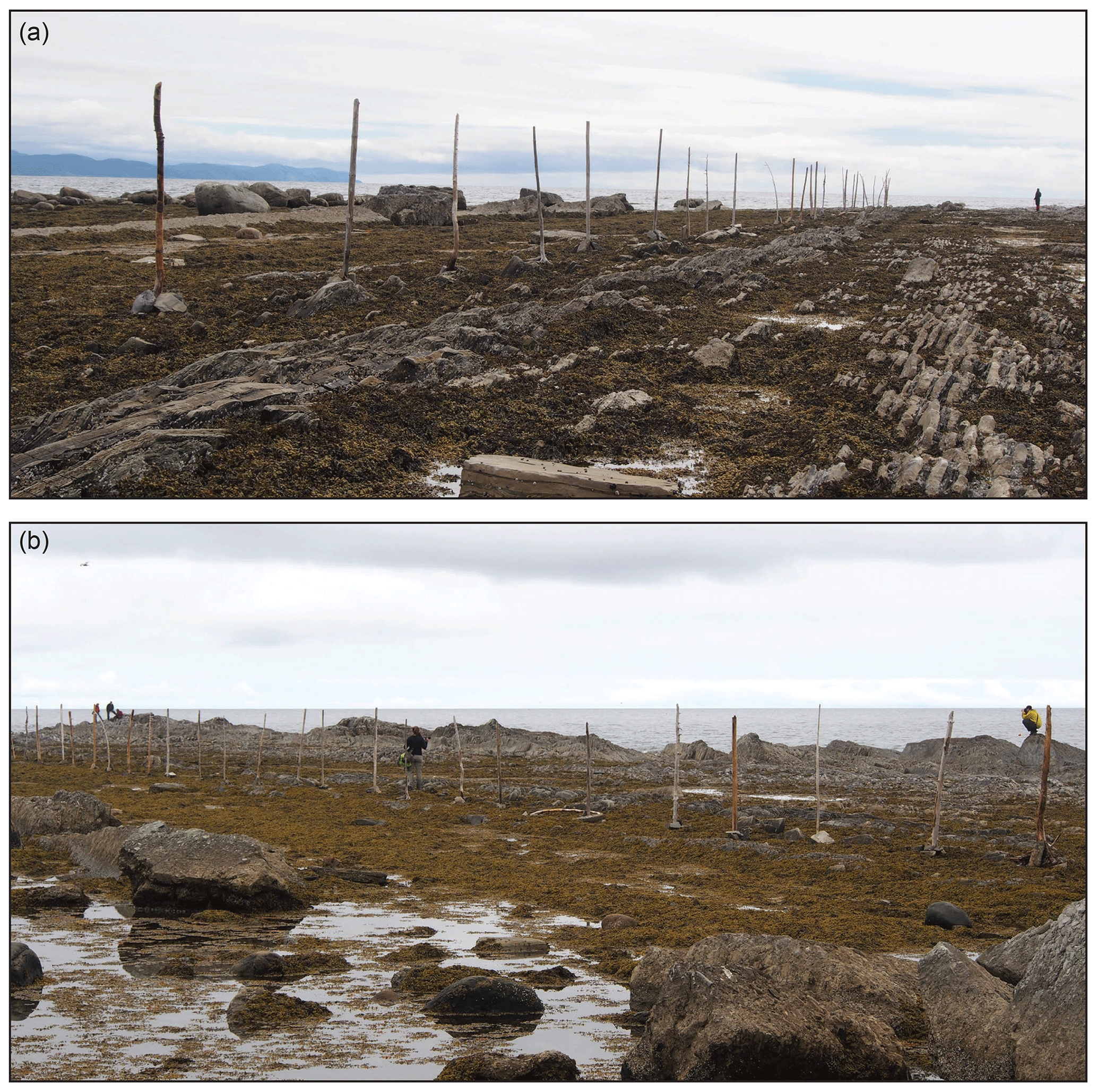
Figure 3Completed installation viewed at low tide. (a) Completed Boundary|Time|Surface installation; artist for scale. (b) View of completed Boundary|Time|Surface installation with viewers engaging with the work.
3.3 Documentation of the installation
The installation was documented in a time-lapse photographic sequence, video, and individual still photographs over the course of the construction day from before the beginning of construction until last daylight at ∼21:00 LT. The time-lapse sequence was recorded from the shoreline near to the location of the first pole installed; it comprises 4023 images taken at 10 s intervals and represents the most complete documentation of the installation process (Fig. 4a–h). Video was captured from two cameras; one was positioned on the clifftop (Fig. 5), and one was hand held. In addition, Lancaster used a head-mounted video camera to capture the installation from an installer's point of view over the course of the 4 h installation period (Fig. 6a–d). Video captured by Lancaster also recorded discussions between Lancaster, Waldron, and the volunteers regarding the process of construction as it pertained to the geology of the area and various choices and complications that arose over the course of building the work. Over 400 still photographs of the work, from various vantage points, were also captured over the course of the day and also on the following morning from the clifftop to record the remains of the installation after the high-tide cycle of the previous night. The cliff face, wave-cut platform, and surrounding landscape were also extensively documented in video and still photographs in the days both before and after the installation was created; this documentation included approximately 2 h of raw video and an additional 550 still images. See Appendix A for a full list of all equipment used in documenting the work.

Figure 4Samples from time-lapse sequence of photographs taken at 10 s intervals during the construction and dissolution of the installation. (a) Site immediately before installation began. (b) Start of installation on falling tide. (c) Towards the end of the installation. (d) Completed installation near low tide. (e–h) Afternoon and evening dissolution of the sculpture during rising tide.
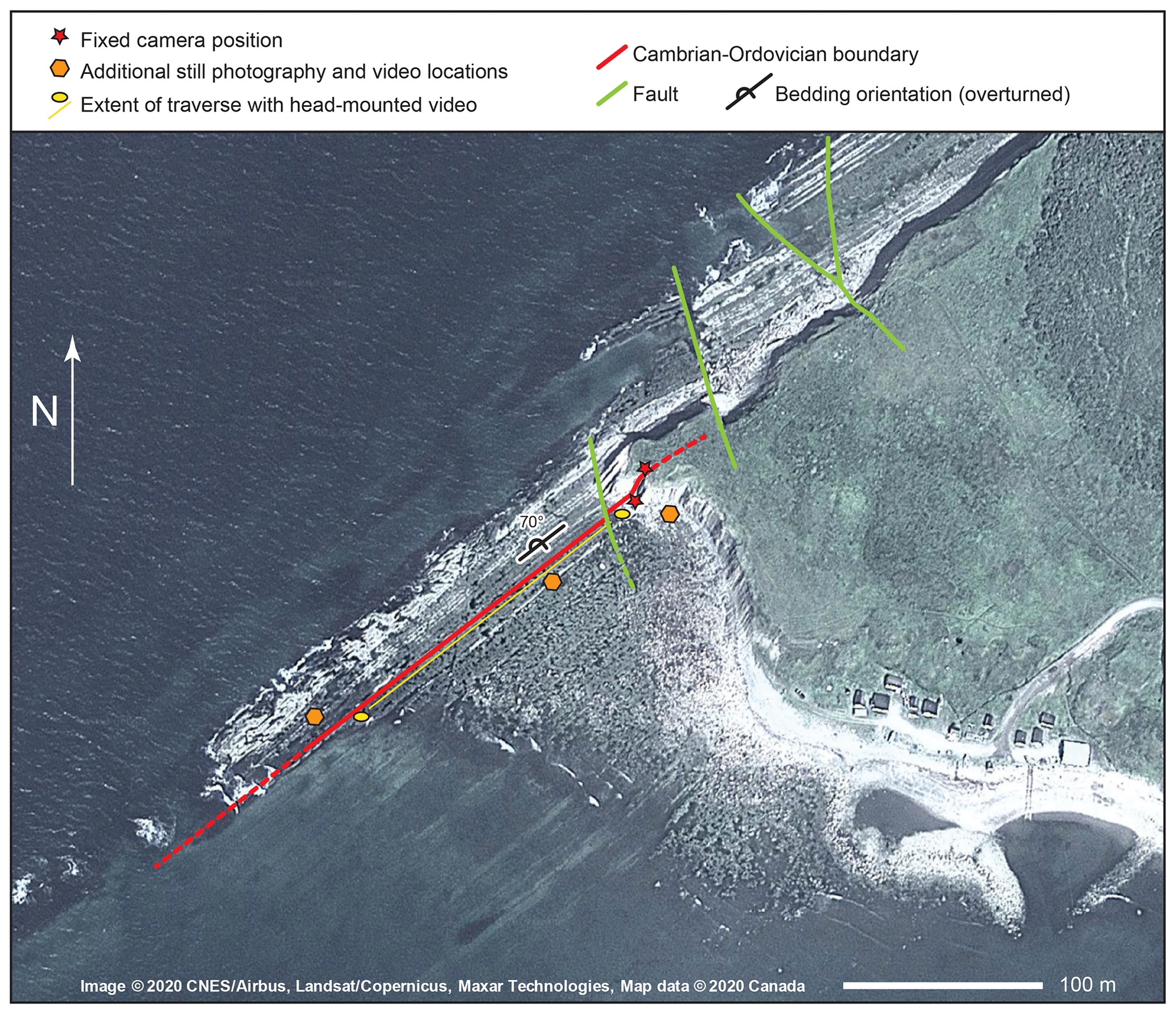
Figure 5Satellite view of Green Point stratotype area showing the location of the installation and recording locations. Imagery: © 2020 CNES/Airbus, Landsat/Copernicus, and Maxar Technologies. Map data: © 2020 Canada.
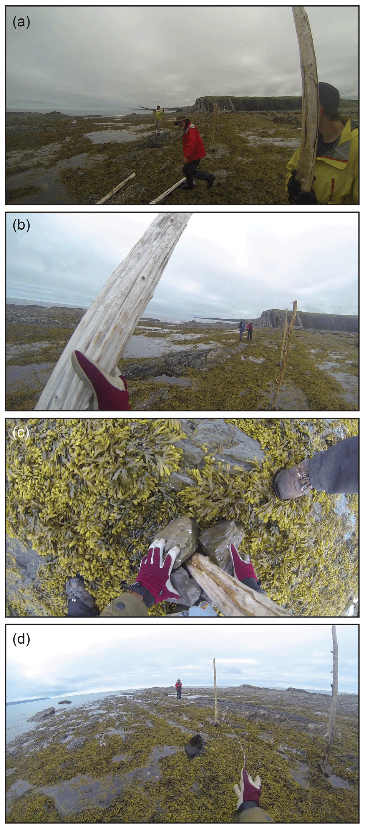
Figure 6(a–d) Still images from GoPro™ – first author's head-mounted camera – taken during the installation process.
3.4 Related site-specific work
After the construction and destruction of the main installation, there was an opportunity to create smaller site-specific works at and around the Cambrian–Ordovician boundary stratotype. The principal materials for these came from a rock material that contrasted with the limestone and fissile shale that forms the bedrock at Green Point. This material was pencil slate from a location further inland within Gros Morne National Park where the deformation of Ordovician shale has imparted a fabric – slaty cleavage – causing the rock to split most easily along planes at a high angle to the original bedding while still retaining some of its bedding-parallel fissility. As a result, the rock splits into pencil-like rods, which were used to build smaller-scale sculptures along the Cambrian–Ordovician boundary. These were documented photographically and formed an addition to the published work. Examples are shown in Fig. 7a–c.

Figure 7(a–b) Examples of pencil slate sculptures built on the Cambrian–Ordovician boundary after the main Boundary|Time|Surface installation. (c) Construction of sculptures; artist for scale.
When creating site-specific ephemeral artworks, finding ways to increase the audience is an immediate and ongoing challenge. There is no way to replicate the original work; part of its impact is the direct relationship of the artwork to its location in the environment. Moreover, the original installation may no longer exist in a recognizable form, thus eliminating a tangible reference point for a viewer to seek out a personal experience. The documentation of the work complicates reception further as it is by its nature an “edited version” of what once existed. These records are captured from particular vantage points and, thus, can never convey the entire experience of the original installation nor its complete context. Consequently, using the documentation of site-specific work to increase the audience for an ephemeral work amounts to an act of translation. Despite these limitations, however, the presentation of this project in a range of contexts has offered a variety of opportunities to stimulate reflection and the transmission of ideas and information that are not immediately available to the viewer at the site of the original. In particular, the collected visual materials allow the simultaneous presentation of different types of information and scales of time, providing opportunities for the viewer to create connections between ideas and images and to contemplate those connections at their own pace (O'Rourke, 2016). For this project, the authors have employed gallery exhibitions, talks, and a book.
4.1 Gallery exhibitions
Two exhibitions of work arising from the original installation project have been completed at the time of writing; one in Newfoundland, Canada, and one in Alberta, Canada. The Newfoundland exhibition took place in the Gros Morne National Park Discovery Centre, a facility incorporating an art gallery and a series of exhibits about the natural environment and history of the park itself. For this exhibition, we designed a brief introductory panel (Fig. 8a) and two didactic panels in English and French (Fig. 8b; Fig. S1 in the Supplement), appropriate to the museum setting, to outline the history and scientific significance of the Green Point section. The second exhibition took place in the Art Gallery of St. Albert, Alberta. For the art gallery setting, only the brief introductory panel was used.
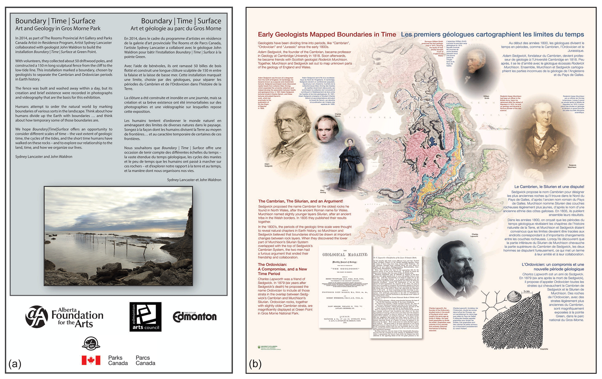
Figure 8(a) Introductory panel for exhibitions. (b) One of two didactic panels created by the authors, using their own work and images in the public domain, for use in Discovery Centre exhibition. Larger versions and sources are provided in the Supplement. Additional imagery and French translation were provided by Parks Canada.
For gallery presentations of Boundary|Time|Surface, it was vital that work derived from the documentation of the original installation conveyed a sense of different scales of time evident in the site in as many ways as possible; video was an ideal tool for addressing this concern. Multi-panel video installations were developed that incorporated several clips, with some shot in “real time”, some in time-lapse, and some in slow motion. In these installations, time operates at different scales on different screens, emphasizing the experience of scales of time simultaneously present at the original site, namely clock time, the diurnal cycle, the tide cycle, human historical time, and geological time. The presentation of the main video works as projection-mapped multi-panel installations also emphasized shifts in physical scale and referred to the spatial, sculptural nature of both the landscape and the installation itself. Video clips ranged from long-distance shots, incorporating large sections of the beach and cliff, to close-up segments as the incoming tide covered the lens of the camera, revealing the range of aquatic life below the surface. In each exhibition, the video installation was remapped to the specific gallery environment, further reinforcing the specificity of experience in both the original site and in the gallery (Fig. 9a).
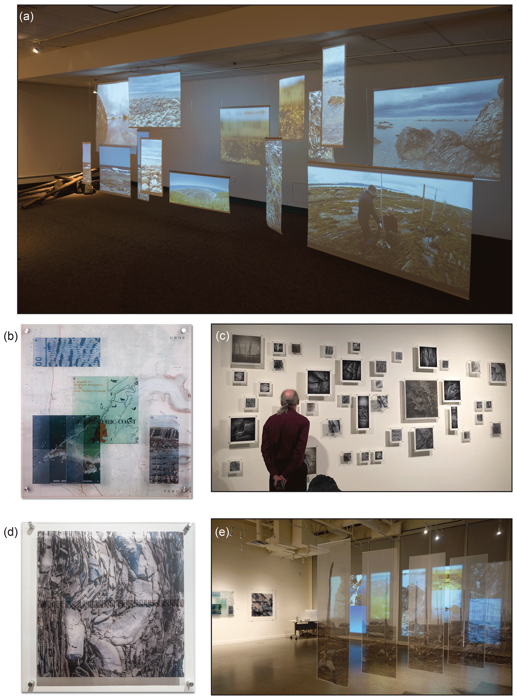
Figure 9Mounted exhibition in gallery setting. (a) Discovery Centre gallery exhibition view showing the projection-mapped video installation with driftwood logs and beach cobbles in the background. (b) “The Historic Coast” – multilayer gel-transfer print work showing a topographical map, enlarged seismic profile, photo of Green Point cliff, satellite image of Green Point, historical book cover, and images of conodont teeth (). (c) View of photo-based print installation showing levels of transparency in the work. (d) “167 Lifetimes” – gel-transfer print work showing enlarged detail of bedded limestone and shale in outcrop at Green Point, NL; glass paint was used to create 167 tick marks across the image, each representing one 80-year human lifespan (). (e) Art Gallery of St. Albert; exhibition view showing silk organza panels, video installation, and print works in the background.
Photographs and gel-transfer prints of photos, maps, and text were used to suggest the range of information that has been gathered about Green Point over time. These different ways of understanding the place – a seismic reflection profile shot in the adjacent Gulf of Saint Lawrence, stratigraphic columns of the cliff surface, Google Maps, topographic maps, images of conodont fossils, and photos of the landscape – are discrete methods of interrogating the significance of the site but each method taken in isolation provides only an imperfect understanding. As in the video, these printed images explored and disrupted both physical and temporal scales; images of the landscape and cliff face were presented on a range of semitransparent and transparent media in both panoramic and close-cropped formats, and the scales of the images were not correlated to each other or to a base map (Fig. 9b–c). For example, a work titled 167 Lifetimes (Fig. 9d) presented an enlarged image of shale and limestone beds on the shore, which were 10–12 cm across in outcrop; the printed image is a ∼76 cm square and has a series of 167 tick marks drawn over it in glass paint. Each tick mark represents one 80-year human lifespan; the total duration – about 13 000 years – is our rough estimate of the length of time it would have taken for these beds to be deposited, based on the stratigraphic work of James and Stevens (1986) and the timescale of Cooper et al. (2012).
A multi-panel installation printed on translucent silk panels allowed viewer interaction; this work presented a photograph of the original installation of driftwood poles divided into sections and presented in 3D space, allowing enough room for visitors to walk between the panels. The intention of this work was two-fold: first, to provide an opportunity for the gallery visitor to connect to the experience of walking along and between the line of poles at Green Point and, second, to emphasize the ephemeral nature of the original installation and, by extension, that of all human-made borders and boundaries. The lightweight silk organza offers transparency and movement, suggesting a mirage or dream that the viewer can pass through (Fig. 9e).
4.2 Public presentations
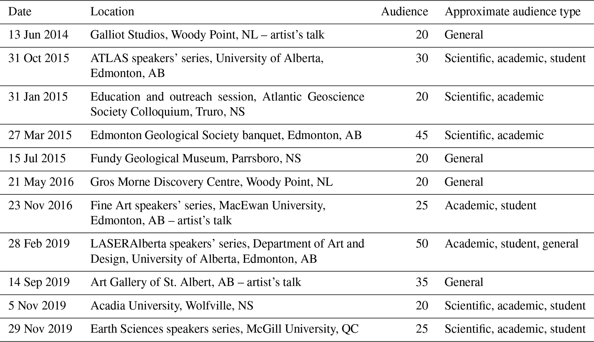
Another means of extending the reach of the project has been through slide- and video-enhanced talks to a wide range of audiences. In addition to the poster presentation at the European Geosciences Union in 2015, in the last 6 years Lancaster and Waldron have given 11 presentations in total on Boundary|Time|Surface: four to general audiences in Newfoundland, Nova Scotia, and Alberta and seven to scientific and/or academic audiences in Alberta, Nova Scotia, Newfoundland, and Québec. Audiences ranged in size between roughly 20 and 35 for each of the general audience presentations and between 25 and 50 for the scientific and/or academic audiences (see Table 1). Questions received at the public presentations indicated a high level of interest and engagement from both artists and scientists.
Table 1Presentations by date and location. Note: NL – Newfoundland; AB – Alberta; NS – Nova Scotia; QC – Québec.
4.3 Book: Boundary|Time|Surface – a record of change
In addition to talks and exhibitions, a limited-edition book on the project was published in 2019 to coincide with the second gallery exhibition of work derived from the original project. The print run was limited to 200 copies, signed and numbered, printed in full colour. Boundary|Time|Surface – a record of change (Lancaster and Waldron, 2019) contains essays on the project from art historian and curator Melinda Pinfold (2019), an essay from Waldron (2019) on the history of geology, and an essay and poetry from Lancaster (2019b, a) reflecting on her development and execution of the project. In addition, the book presents a wide range of visual material, including photographs of Green Point, the original Boundary|Time|Surface installation, and work presented in galleries. The book is held in private collections in Alberta, Nova Scotia, Newfoundland, Québec, and two copies are stored with the national Library and Archives of Canada. Remaining copies of the book are available internationally via Lancaster's website, through the Art Gallery of Alberta gift shop, and the Atlantic Geoscience Society.
5.1 Exhibition attendance and feedback
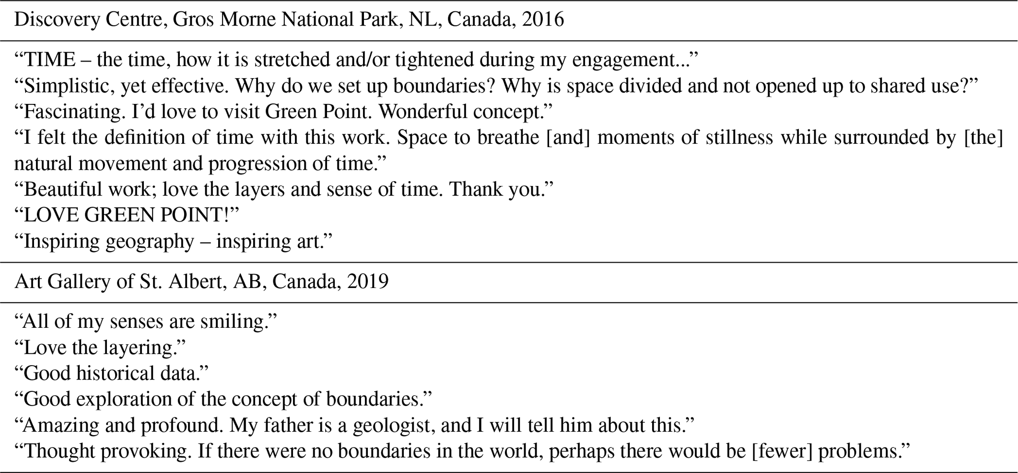
Overall attendance at the Discovery Centre from 20 May 2016 to 10 October 2016 was 34 787 people; while no separate attendance records were kept specifically for the art gallery at the Parks Canada Discovery Centre, Parks Canada assumes that the overall visitor numbers for a season reflect exhibition visits as well (R. Hingston, Parks Canada, personal communication, 2019). A total of 390 people signed the guest book left in the gallery (see Fig. S2 in the Supplement). The highest proportion of visitors were Canadian and included individuals from all provinces and two of the three territories. There were a number of visitors from several states in the USA and several from western European countries including France, Switzerland, Austria, Spain, and England. There were also visitors from Australia, New Zealand, British Virgin Islands, Thailand, and China. Comments were positive but tended to be of a general nature, in part due to the limited space afforded for recording responses to the exhibition. Nonetheless, there were some comments that indicated that people spent time with the exhibition and were responding to the more abstract ideas presented therein (Table 2).
For the second exhibition of work, at the Art Gallery of St. Albert in the City of St. Albert, Alberta, approximately 1000 people visited the exhibition between 5 September and 2 November 2019; an additional 150 attended the opening reception. Response to the exhibition was positive, and the curator noted that:
Any gallery patrons who had previously visited Gros Morne National Park instantly recognized it as the site of your works. Many visitors enjoyed the blending of art and science in your exhibition and spent a long time engaging with the various elements of your immersive exhibition. (J. Willson, Art Gallery of St. Albert, personal communication, 2019)
There were 28 entries in the Art Gallery of St. Albert guest book (see Fig. S2 in the Supplement); several of these corroborated the curator's comments and reflected the viewers' engagement with both Green Point and the underlying concepts, in particular with the concept of time as embodied in the work (Table 2).
5.2 Perspectives on art–science relationships
Boundary|Time|Surface attempted to convey ideas about science and art, and their relationship, to a wider, nonspecialist public. For the collaborators, this ongoing dialogue resulted in a stronger understanding of their respective disciplines overall and their individual approaches to communicating ideas. Beginning with early discussions between the collaborators, the project spurred the creation of a series of works of the type that Bowker and Starr (1999) have described as “boundary objects” which can inhabit our respective disciplines and satisfy both of them simultaneously. In this sense, Boundary|Time|Surface has enriched our respective understanding of each others' disciplines and allowed us to create something more than we could each do alone to contribute to the dissemination of ideas about the Earth, time, and humanity's relationship with the planet. Boundary|Time|Surface spoke to each disciplinary context in a legible and meaningful way, “without fitting so well as to be naturalized” within each of them (Loveless, 2019).
Table 2Examples of visitor responses to exhibitions at the Discovery Centre, Gros Morne National Park, NL, Canada, and the Art Gallery of St. Albert, AB, Canada. Complete visitor responses are listed in the Supplement.
Both the original installation and the subsequently developed work allowed audiences to explore the ways in which humans understood and acquired knowledge about this place and how a particular world-view always informs a process of inquiry (Bachelard, 1994), even if it remains unacknowledged. Furthermore, the exhibition environment, in particular, offered the opportunity for contemplative reflection, allowing viewers the physical and mental space to consider their own assumptions and those of others in relation to time and their role on the planet. The original work, and the various methods of communicating the experience of its brief existence, is an ongoing project to destabilize the fantasy that humans are somehow separate from the Earth (Boetzkes, 2010), its systems and timescale – and the notion that borders, boundaries, and other forms of territoriality are somehow permanent.
Gros Morne National Park – and Green Point in particular – lends itself perfectly to integrating artistic expression with scientific understanding of the natural world. The locale afforded the opportunity not only to create a large sculptural installation with immediate visual and metaphorical impact but also to make work that blurred the boundaries of artistic and scientific practice in a tangible way, both for the authors and for a wider public.
Visitors to the site were able to engage with both the scientific and artistic aims of the project on a number of levels simultaneously, as they had a tangible, visual “anchor” for the underlying ideas. Extending the reach of the original installation through public talks, the development of gallery presentations of new work, and the publication of a book has allowed Boundary|Time|Surface to be experienced in a number of different ways by much larger numbers of people since its initial creation. Using a range of strategies to convey both scientific and sociopolitical concepts associated with the original ephemeral installation has provided multiple entry points for a wider audience to appreciate the geology and history of Green Point and geology as a human endeavour. Furthermore, the temporal quality of work derived from the original installation invites viewers to consider the different scales of time present in the original site and, by extension, provides an opportunity to contemplate the human concept of time in relation to our actions on the planet vis á vis the scale of geological time.
| – Canon EOS 5D Mark II digital camera; Canon EF 24–105 mm zoom lens |
| – Hähnel Giga T Pro II 2.4 GHz wireless timer remote (attached to Canon 5D camera for time-lapse photography). |
| – GoPro Hero 4 silver video camera with head mount |
| – Olympus E-M5 digital camera; Olympus Zuiko, 12–50 mm lens |
| – Olympus E-500 digital camera; Olympus Zuiko, 40–150 mm lens |
All data used in this study are available in the Appendices and in the Supplement.
The supplement related to this article is available online at: https://doi.org/10.5194/gc-3-249-2020-supplement.
SAL created the artistic content and wrote the sections of the text describing these aspects. JWFW wrote the sections on stratigraphy and history of geology. Both authors collaborated in the editing of this paper, descriptions of their contributions to the project, and diagram preparation.
As a professional artist, SAL has an interest in the sale of the works derived from the project and described in this paper.
This article is part of the special issue “Five years of Earth sciences and art at the EGU (2015–2019)”. It is not associated with a conference.
The authors wish to thank the Art in the Park artists' residency program for the opportunity to create the original installation, and Rob Hingston, Munju Ravindra, Kirsten Oravec, Fred Sheppard, and many other Parks Canada staff for their assistance in making the project a success. Thanks also goes to the volunteers for their efforts and enthusiasm, particularly Michael Burzynski, Ryan Lacombe, Lisa Liu, Anne Marceau, Renée Martin, and Shawna White, who assisted in the construction of the installation at Green Point. We thank Tiziana Lanza for the opportunity to write this contribution, and we are extremely grateful for the comments of Tim Fedak, Matthew Stiller-Reeve, Graham Young, and Simone Rödder, which led to significant improvements in the paper.
The 2014 Residency travel costs were supported by the Edmonton Arts Council CIP Travel (grant no. 582322-1141), and in-kind accommodation for the residency was provided by Parks Canada. The artist stipend was provided through Art in the Park Program administered by The Rooms Provincial Art Gallery, St. John's, NL, from funds provided by the Canada Council for the Arts, and the creation of the artwork for exhibition was supported by the Alberta Foundation for Arts Individual Project (grant no. AFA-VIPG-14-037598). The design, printing, and publication of the book Boundary|Time|Surface – a record of change was funded by the Alberta Foundation for the Arts Individual Project (grant no. AFA-VIPG-14-075244).
This paper was edited by Angela Saraò and reviewed by Tim Fedak, Graham Young, and Simone Rödder.
Bachelard, G.: The Poetics of Space, Beacon Press, Boston, 1994.
Bassett, M. G. and Dean, W. T. (Eds.): The Cambrian–Ordovician Boundary: Sections, Fossil Distributions, and Correlations, Geological Series. National Museum of Wales, Cardiff, 1982.
Becker, R. T., Gradstein, F. M., and Hammer, O.: The Devonian Period, in: The Geological Timescale 2012, edited by: Gradstein, F. M., Ogg, J. G., Schmitz, M., and Ogg, G., 559–601, Elsevier, Amsterdam, Boston, 2012.
Boetzkes, A.: The Ethics of Earth Art, University of Minnesota Press, Minneapolis, 2010.
Bowker, G. and Starr, S. L.: Sorting Things Out: Classification and its Consequences, MIT University Press, Cambridge MA, 1999.
Casey, E. S.: Earth Mapping: Artists Reshaping Landscape, University of Minnesota Press, Minneapolis, 2005.
Chandna, M.: Spatial Boundaries And The Colonial Project, Cornell University, 13 October, available at: https://ecommons.cornell.edu/handle/1813/13953 (last access: 11 January 2020), 2009.
Cook, E.: James Turrell and Roden Crate Introduction, Roden Crater Art Vis. James Turrell 1978 – Year Proj, available at: https://www.lasersol.com/art/turrell/rc_intro.html (last access: 11 January 2020), 2010.
Cooper, R. A., Nowlan, G. S., and Williams, S. H.: Global Stratotype Section and Point for base of the Ordovician System, Episodes, 24, 19–28, 2001.
Cooper, R. A., Sadler, P. M., Hammer, O., and Gradstein, F. M.: The Ordovician Period, in: The Geologic Time Scale 2012, edited by: Gradstein, F. M., Ogg, J. G., Schmidtz, M., and Ogg, G., 489–523, Elsevier, Amsterdam, 2012.
Dapena-Tretter, A.: Richard Long's Passage as Line: Measuring Toward the Horizon, Iowa, J. Cult. Stud., 15, 103–116, 2014.
Fredricksen, E.: Roden Crater, Archit. AIA J., 91, 90–97, 2002.
Gieryn, T. F.: The Boundaries of Science, in: Handbook of Science and Technology Studies, edited by: Jasanoff, S., Markle, G. E., Petersen, J. C., and Pinch, T., 393–443, SAGE Publications, Inc., Thousand Oaks, CA, 1995.
Goldsworthy, A.: Time, Abrams, New York, 2000.
Gooding, M.: Artists Land Nature, Abrams, Cameron Books, New York, 2002.
Gradstein, F. M., Ogg, J. G., Schmitz, M. and Ogg, G. (Eds.): A Geologic Time Scale 2012, Elsevier, Amsterdam, 2012.
Harrison, M.: Science and the British Empire, ISIS, 96, 56–63, 2005.
Hedberg, H. D. (Ed.): International stratigraphic guide: a guide to stratigraphic classification, terminology, and procedure, Wiley, New York, 1976.
Hopkins, D.: After Modern Art 1945–2000, Oxford UP, Oxford, 2000.
Hutton, J.: Theory of the Earth, Trans. R. Soc. Edinb., 1, 209–305, 1788.
James, N. P. and Stevens, R. K.: Stratigraphy and correlation of the Cambro–Ordovician Cow Head Group, Western Newfoundland, Geological Survey of Canada, Ottawa, https://doi.org/10.4095/125053, 1986.
Lacombe, R. A., Waldron, J. W. F., Williams, S. H., and Harris, N. B.: Mélanges and disrupted rocks at the leading edge of the Humber Arm Allochthon, W. Newfoundland Appalachians: deformation under high fluid pressure, Gondwana Res., 74, 216–236, 2019.
Lancaster, S. A.: Strata, in: Boundary|Time|Surface: a Record of Change, edited by: Lancaster, S. A. and Waldron, J. W. F., 46–50, Arts and Heritage Foundation, St. Albert, 2019a.
Lancaster, S. A.: Toeing the Line: Borders and other Ephemeral Beasts, in: Boundary|Time|Surface: a Record of Change, edited by: Lancaster, S. A. and Waldron, J. W. F., 12–24, Arts and Heritage Foundation, St. Albert, 2019b.
Lancaster, S. A. and Waldron, J. W. F.: Boundary|Time|Surface – a record of change, Arts and Heritage Foundation, St. Albert, 2019.
Lapworth, C.: On the Tripartite Classification of the Lower Palaeozoic Rocks, Geol. Mag. New Ser., 6, 1–15, 1879.
Long, R.: Documentary Gallery, Richard Long Off, available at: http://www.richardlong.org/documentary.html, last access: 11 January 2020.
Loveless, N.: How to Make At at the End of the World: a Manifesto for Research-Creation, Duke University Press, Durham and London, 2019.
Lubow, A.: 35 Who Made a Difference: Andy Goldsworthy, Smithson. Mag., available at: https://www.smithsonianmag.com/arts-culture/35-who-made-a-difference-andy-goldsworthy-114067437/ (last access: 11 January 2020), 2005.
Martinsson, A.: The Silurian–Devonian boundary: final report of the Committee of the Siluro–Devonian Boundary within IUGS Commission on Stratigraphy and a state of the art report for Project Ecostratigraphy, 1977.
Melchin, M. J., Sadler, P. M., Cramer, B. D., Cooper, R. A., Gradstein, F. M., and Hammer, O.: The Silurian Period, in: The Geologic Time Scale, edited by: Gradstein, F. M., Ogg, J. G., Schmidtz, M., and Ogg, G., 525–558, Elsevier, Amsterdam, Boston, 2012. location.
Nail, T.: Theory of the Border, Oxford UP, Oxford, 2016.
Ogg, J. G.: The Triassic period, in: The Geologic Time Scale, edited by: Gradstein, F. M., Ogg, J. G., Schmidtz, M., and Ogg, G., 681–730, Elsevier, Amsterdam, Boston, 2012.
O'Rourke, K.: Walking and Mapping: artists as Cartographers, MIT Press, Cambridge, MA, 2016.
Pinfold, M.: Now is the boundary between the past and the future, in: Boundary|Time|Surface: a Record of Change, edited by: Lancaster, S. A. and Waldron, J. W. F., 2–10, Arts and Heritage Foundation, St. Albert, 2019.
Rödder, S.: The Climate of Science–Art and the Art–Science of the Climate: Meeting Points, Boundary Objects and Boundary Work, Minerva, 55, 93–1166, https://doi.org/10.1007/s11024-016-9312-y, 2017.
Sedgwick, A. and Murchison, R. I.: On the Silurian and Cambrian systems, exhibiting the order in which the older sedimentary strata succeed each other in England and Wales?: Report of the British Association for the Advancement of Science (5th), 1836, Transactions of the sections (Geology), 59–61, Br. Assoc. Adv. Sci. Trans. Sect. Geol., 5, 59–61, 1836.
Sedgwick, A. and Murchison, R. I.: Stratification of the older stratified deposits of Devonshire and Cornwall, Philos. Mag., Series 3, 14, 241–260, 1839.
Smith, W.: A Delineation of the Strata of England and Wales with Part of Scotland, available at: https://upload.wikimedia.org/wikipedia/commons/2/2a/Geological_map_-_William_Smith%2C_1815_-_BL.jpg (last access: 22 June 2019), 1815.
Smithson, R.: “Spiral Jetty” Earthwork Sculpture, Rozel Point, Great Salt Lake Utah, US, 1970.
Smithson, R.: Robert Smithson: The Collected Writings, edited by: Flam, J., University of California Press, Berkeley, 1996.
Steno, N.: De solido intra solidum naturaliter contento dissertationis prodromus, Accademia della Crusca, Florence, 1669.
The Art Story, C.: Earth Art Movement Overview and Analysis, Art Story – Mod. Art Insight, available at: https://www.theartstory.org/movement/earth-art/ (last access: 14 January 2020), 2015.
The Art Story, C.: Andy Goldsworthy Sculptures, Bio, Ideas, Art Story, available at: https://www.theartstory.org/artist/goldsworthy-andy/ (last access: 11 January 2020), 2018.
Tufnell, B.: Land Art, Tate Publishing, London, 2006.
Turrell, J.: Roden Crater, Roden Crater, available at: http://rodencrater.com/about/, last access: 11 January 2020.
Waldron, J. W. F.: Time, geology, and Green Point, in: Boundary|Time|Surface: a Record of Change, edited by: Lancaster, S. A. and Waldron, J. W. F., 26–44, Arts and Heritage Foundation, St. Albert, 2019.
Whittington, H. B. and Kindle, C. H.: Cambrian and Ordovician stratigraphy of Western Newfoundland, in: North Atlantic: Geology and Continental drift, edited by: Kay, M., 12, 655–664, 1963.
Winchester, S.: The map that changed the world: William Smith and the birth of modern geology, Perennial, New York, NY, 2002.
Wood, D.: Deep Time, Dark Times: On Being Geologically Human, Fordham UP, New York, 2019.
Zeller, S.: The Colonial World as Geological Metaphor: Strata(gems) of Empire in Victorian Canada, Osiris, 15, 85–107, 2000.
- Abstract
- Introduction
- Geological background
- Boundary|Time|Surface: implementation of the installation
- Outreach and communication activities
- Discussion
- Conclusions
- Appendix A: List of equipment
- Data availability
- Author contributions
- Competing interests
- Special issue statement
- Acknowledgements
- Financial support
- Review statement
- References
- Supplement